Technology & Systems Intelligence

Technology and systems intelligence examine how advanced analytical tools and digital technologies can enhance our understanding of complex systems. Technologies such as artificial intelligence, machine learning, sensor networks, and large-scale data analytics are increasingly used to analyze environmental, economic, and social systems.

Systems intelligence emphasizes the ability to integrate data, models, and human expertise in order to interpret complex patterns and support informed decision-making. Rather than replacing human judgment, these technologies augment the capacity of researchers and institutions to detect trends, simulate outcomes, and evaluate policy interventions.

As digital technologies become more deeply integrated into governance and sustainability research, the challenge lies in deploying them responsibly. Effective systems intelligence requires transparency, accountability, and careful integration with ethical and institutional frameworks.

Basin-scale watershed monitoring diagram showing mountain headwaters, rivers, wetlands, stream gauges, groundwater wells, telemetry links, data platforms, hydrological analytics, and governance review.

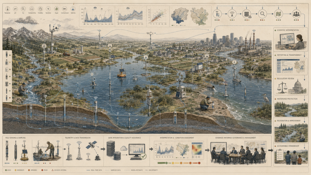
River and Watershed Monitoring Networks: Basin-Scale Monitoring and Hydrological Accountability

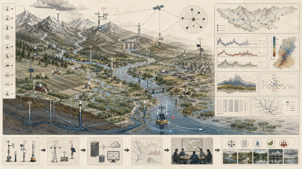
River and watershed monitoring networks make hydrological systems visible across entire basins, from mountain headwaters to downstream floodplains. Stream gauges, rain gauges, weather stations, water-quality probes, groundwater wells, reservoir sensors, buoy platforms, telemetry masts, solar-powered field nodes, and satellite links help track how water moves through rivers, wetlands, farms, towns, infrastructure, and ecosystems. This article examines how basin-scale monitoring connects flow, water quality, groundwater conditions, precipitation, storage, risk signals, and downstream impacts into a shared evidence system. Watershed accountability depends on more than isolated measurements; it requires reliable observation, data integration, uncertainty awareness, institutional review, and stewardship decisions across the whole basin. By linking hydrological evidence to governance, river and watershed monitoring supports water security, ecological protection, flood preparedness, and public responsibility.

Water quality monitoring diagram showing river sensors, sampling stations, telemetry links, laboratory testing, data platforms, condition assessment, and aquatic governance pathways.

Water Quality Monitoring Systems: Sensors, Sampling, and Aquatic Governance

Water quality monitoring systems connect field sensing, sampling, laboratory evidence, and aquatic governance into a shared framework for protecting rivers, wetlands, groundwater, and downstream ecosystems. Sensors and sampling stations measure temperature, pH, dissolved oxygen, conductivity, turbidity, nutrients, algae, contaminants, salinity, flow conditions, and groundwater signals across landscapes shaped by agriculture, urban infrastructure, industry, restoration, and ecological change. This article examines how water quality evidence becomes meaningful when it is supported by telemetry, sampling protocols, laboratory analysis, quality assurance, uncertainty assessment, data integration, public reporting, and regulatory review. Effective monitoring is not only about detecting pollution; it is about linking aquatic condition to stewardship, watershed protection, restoration priorities, compliance, and public accountability. By connecting measurement to governance, water quality monitoring supports healthier aquatic systems and more responsible environmental decision-making.

Climate early warning systems diagram showing satellites, weather stations, hazard forecasts, risk maps, alert pathways, emergency coordination, and protective action.

Climate Early Warning Systems: Forecasts, Risk, and Protective Lead Time

Climate early warning systems turn forecasts into protective lead time. Satellites, radar, weather stations, ocean buoys, river gauges, soil sensors, climate models, forecast ensembles, risk maps, and communication networks help detect hazards before they become disasters. This article examines how early warning systems connect climate observation, hazard forecasting, exposure analysis, vulnerability assessment, alert thresholds, emergency coordination, public communication, evacuation planning, sheltering, infrastructure protection, and community response. Effective warning depends not only on technical prediction, but on trust, accessibility, institutional capacity, and timely action. By linking forecasts to risk assessment and protective decisions, climate early warning systems help communities prepare for floods, storms, heat, drought, wildfire, coastal hazards, and extreme rainfall while strengthening resilience, accountability, and climate adaptation.

Restrained atmospheric monitoring diagram showing satellites, radar, weather balloons, surface stations, ocean buoys, telemetry, models, forecasts, uncertainty, and decision-support pathways.

Weather Sensing and Atmospheric Data Systems

Weather sensing and atmospheric data systems turn distributed observations into atmospheric intelligence. Satellites, radar, radiosondes, aircraft, drones, surface weather stations, rain gauges, wind profilers, lightning sensors, ocean buoys, air-quality instruments, and hydrologic sensors collect evidence across mountains, coastlines, cities, farms, oceans, and river basins. This article examines how atmospheric data becomes useful through telemetry, quality control, data assimilation, numerical weather prediction, nowcasting, forecast uncertainty, alert thresholds, institutional review, and decision-support pathways. Weather sensing is not only about measuring current conditions; it is about producing reliable evidence for aviation safety, marine operations, agriculture, flood preparedness, heat risk, air quality, infrastructure management, and community protection. By linking observation to modeling and action, atmospheric data systems support clearer forecasts, better decisions, and more accountable public safety.

Restrained climate monitoring diagram showing satellites, cryosphere stations, weather stations, ocean buoys, flux towers, river gauges, climate indicators, long-term trend records, and environmental decision-support pathways.

Climate Monitoring Systems and Environmental Observation

Climate monitoring systems turn long-term environmental observation into evidence for understanding planetary change. Satellites, weather stations, ocean buoys, glacier monitors, flux towers, river gauges, soil sensors, biodiversity observations, aircraft, radiosondes, and atmospheric instruments measure conditions across atmosphere, land, ocean, cryosphere, ecosystems, and human settlements. This article examines how climate evidence becomes useful through telemetry, harmonization, quality control, climate data records, trend detection, attribution, uncertainty assessment, reporting, and archival stewardship. Climate monitoring is not only about tracking warming; it connects temperature, precipitation, sea level, ocean heat, greenhouse gases, vegetation change, wildfire smoke, soil moisture, river discharge, biodiversity condition, and carbon-cycle signals to public decision-making. By linking observation to accountability, climate monitoring supports adaptation, risk assessment, infrastructure planning, ecological stewardship, and climate governance.

Air quality monitoring systems diagram showing urban sensors, fixed stations, mobile labs, satellites, pollutant plumes, exposure maps, data workflows, and atmospheric governance pathways.

Air Quality Monitoring Systems: Sensors, Networks, and Atmospheric Governance

Air quality monitoring systems turn atmospheric measurements into evidence for public health, environmental accountability, and atmospheric governance. Fixed stations, roadside monitors, rooftop sensors, low-cost nodes, mobile laboratories, drones, satellites, meteorological towers, lidar systems, and profiler networks help track particulate matter, ozone, nitrogen dioxide, sulfur dioxide, carbon monoxide, volatile organic compounds, black carbon, wind flows, inversion layers, pollutant plumes, and exposure gradients. This article examines how air quality evidence becomes meaningful through calibration, data quality checks, uncertainty assessment, exposure mapping, forecasting, public reporting, technical review, and regulatory oversight. Air monitoring is not only about detecting pollution; it is about linking atmospheric conditions to health protection, emissions accountability, urban planning, environmental justice, community awareness, and responsible stewardship of shared air.

Layered edge infrastructure network connecting sensors, industrial devices, gateways, cloud systems, monitoring dashboards, and governance checkpoints.

Standards, Interoperability, and Governance in Edge Infrastructure

Standards, interoperability, and governance in edge infrastructure determine whether heterogeneous devices, gateways, APIs, data models, runtimes, and control planes can operate as a coherent distributed system. Edge environments rarely remain uniform; they combine vendors, protocols, networks, device generations, and management platforms across long operational lifecycles. Standards help define shared expectations, but interoperability only becomes durable when systems preserve meaning across interfaces, data flows, security baselines, and lifecycle transitions. Governance turns those technical relationships into accountable practice by defining versioning rules, support boundaries, decision rights, security expectations, and responsibilities for change. In embedded and edge systems, infrastructure becomes dependable not simply when components connect, but when they remain understandable, portable, secure, supportable, and governable as the system evolves.

Edge device fleet management system showing cloud updates, secure provisioning, monitoring, rollback, and decommissioning across connected industrial devices.

Device Lifecycle Management and Over-the-Air Updating

Device lifecycle management and over-the-air updating determine whether embedded and edge devices remain trustworthy after deployment. Devices do not stay static: they acquire identities, credentials, configurations, software dependencies, policy bindings, update histories, and support obligations across long operational lives. OTA updating is therefore more than remote software delivery. It is a governed process of targeting, compatibility checking, validation, rollout, rollback, recovery, monitoring, and retirement. Strong lifecycle architecture ensures that devices can be provisioned securely, grouped accurately, updated safely, verified continuously, recovered after failure, and decommissioned before unsupported components become systemic risks. In edge infrastructure, lifecycle management is one of the central disciplines that keeps distributed physical-digital systems patchable, observable, recoverable, and accountable.

Secure edge computing architecture showing local data processing, protected devices, filtered data flows, and privacy controls before limited cloud transmission.

Privacy and Local Data Processing at the Edge

Privacy and local data processing at the edge determine whether embedded systems reduce exposure or simply relocate risk. Edge devices often handle intimate, persistent, and person-revealing signals such as audio, video, biometrics, occupancy, location, and behavioral patterns. Processing data locally can reduce unnecessary transfer to centralized platforms, but privacy is not guaranteed by on-device computation alone. Engineers must design the full data lifecycle: what is collected, transformed, retained, linked, logged, disclosed, and governed. Strong privacy-preserving edge systems minimize raw collection, transform data before transfer, limit retention, reduce linkability, document disclosure, and make privacy behavior testable through schemas, policies, manifests, and validation workflows. In edge infrastructure, privacy becomes credible only when local processing measurably changes what data are exposed, for how long, and to whom.

Scroll to Top