
Last Updated May 14, 2026
Air quality monitoring systems are socio-technical observational infrastructures used to measure atmospheric pollutants, interpret their spatial and temporal dynamics, and support public health, environmental governance, and collective decision-making under conditions of uncertainty. They combine sensing technologies, regulatory stations, calibration regimes, telemetry networks, atmospheric models, geospatial platforms, data governance practices, public communication systems, and community-based evidence infrastructures in order to transform air pollution from an often invisible and unevenly distributed hazard into measurable evidence. In this sense, air quality monitoring is not merely the technical act of reading concentrations from instruments. It is the design of an atmospheric evidence system: a structured way of knowing polluted air well enough to compare places, detect change, evaluate interventions, communicate risk, and justify action.
Air pollution illustrates with unusual clarity why environmental monitoring must be understood as a systems problem rather than a narrow measurement task. Pollutants move through dynamic atmospheric processes; concentrations vary across minutes, neighborhoods, seasons, and meteorological conditions; exposure burdens are distributed unequally across populations; and the interpretation of air quality depends not only on sensors, but on siting decisions, calibration, maintenance, data processing, thresholds, models, metadata, uncertainty communication, and institutions. A reading does not speak for itself. It becomes meaningful only within a wider observational architecture that links pollutant measurement to atmospheric context, analytical interpretation, health relevance, public communication, and governance response.
Modern air quality monitoring systems therefore sit at the intersection of atmospheric science, public health surveillance, sensor engineering, urban governance, environmental justice, and data systems design. They support regulatory compliance, epidemiological research, industrial oversight, urban planning, community monitoring, early warning, wildfire-smoke response, climate-related atmospheric analysis, and sustainability strategy. They also shape what becomes visible to institutions and publics. Where monitors are placed, which pollutants are prioritized, how data quality is defined, and how uncertainty is communicated all influence which atmospheric harms can be recognized, governed, and contested. Air quality monitoring is thus both scientific infrastructure and civic infrastructure: it measures atmospheric conditions while also helping determine what societies are willing and able to know about polluted air.
Main Library
Publications
Article Map
Environmental Monitoring
Related Topic
Data Systems
Related Topic
Risk & Resilience
Related Topic
Earth Systems
Air quality monitoring is where atmospheric measurement becomes public-health evidence and civic accountability. It asks not only whether pollutant concentrations can be measured, but whether the resulting evidence can be trusted, compared, interpreted, communicated, and used to reduce harm. The central question is not simply whether air quality data exist. It is whether the monitoring system can make atmospheric risk visible at the scales where people breathe, institutions govern, and environmental burdens accumulate.
Engineering Problem
The engineering problem is how to design air quality monitoring systems that can transform spatially uneven, chemically complex, temporally variable atmospheric signals into trustworthy evidence for health protection, environmental regulation, community accountability, and public decision-making. Air quality monitoring is not only a sensor-deployment problem. It is a full-chain evidence problem involving pollutant selection, instrument technology, siting, calibration, quality control, meteorological context, data transmission, exposure interpretation, threshold logic, public communication, governance, and corrective action.
This problem is difficult because pollutant concentrations are not stable properties of places. They vary with source activity, traffic flows, combustion, industrial operations, wildfire smoke, atmospheric chemistry, inversion conditions, wind direction, humidity, boundary-layer height, topography, building form, and time of day. A monitor at one location can reveal important information while missing nearby exposure gradients. A dense low-cost network can reveal spatial patterns while introducing calibration and drift challenges. A regulatory station can provide highly defensible continuity while failing to capture block-scale hotspots. A satellite product can provide regional context while needing surface validation and careful interpretation.
Weak air quality monitoring treats pollutant measurement as the endpoint. Strong air quality monitoring treats measurement as one layer in an atmospheric evidence chain. It asks whether measurements are representative, calibrated, quality-checked, temporally complete, meteorologically contextualized, interoperable, interpretable, health-relevant, spatially fair, and connected to response. The decisive question is not simply whether pollutant data are available. It is whether the monitoring architecture can support defensible claims about atmospheric risk and unequal exposure.
| Engineering Tension | Why It Matters | Required Evidence |
|---|---|---|
| Measurement precision versus spatial coverage | Reference-grade monitors provide defensible measurements but may be sparse; lower-cost sensors increase density but require stronger validation. | Instrument class, calibration status, collocation results, network-density audit |
| Concentration measurement versus exposure inference | Ambient concentration at a fixed point does not directly equal what people inhale across daily movement and indoor-outdoor transitions. | Exposure model, mobility context, indoor-outdoor caveat, population-at-risk layer |
| Continuity versus hotspot detection | Long-term fixed-site records support trend analysis, while mobile and dense networks reveal micro-scale variation. | Fixed-site record, mobile transects, hotspot map, temporal-comparability note |
| Sensor volume versus data quality | Large sensor networks can create false confidence if drift, humidity effects, cross-sensitivity, or missing metadata are ignored. | QC flags, drift test, humidity correction, sensor metadata, maintenance log |
| Public simplicity versus scientific uncertainty | Air quality indices and dashboards must be understandable without hiding uncertainty, pollutant-specific differences, or vulnerable-population risks. | AQI method, uncertainty note, pollutant-specific dashboard, health communication review |
| Regulatory adequacy versus environmental justice | A network can satisfy formal reporting needs while missing localized burdens near roads, ports, warehouses, industrial corridors, or power facilities. | Equity audit, siting rationale, community-monitoring integration, hotspot assessment |
| Atmospheric measurement versus governance response | Monitoring creates value only when evidence can support warnings, enforcement, planning, intervention, or public accountability. | Decision log, response protocol, advisory rules, intervention evaluation record |
The practical question is therefore: can the system produce air-quality evidence that is accurate enough, spatially meaningful enough, timely enough, and legitimate enough to support public-health and governance decisions?
Reference Architecture
A practical air quality monitoring architecture can be understood as an end-to-end atmospheric evidence system. The exact implementation may include regulatory reference stations, supplemental sensors, mobile monitoring vehicles, community monitoring devices, satellite products, meteorological stations, emissions inventories, telemetry systems, calibration workflows, data-quality pipelines, exposure models, dashboards, public alert systems, regulatory reporting databases, and governance logs. The responsibilities remain consistent: define the monitoring purpose, observe pollutants, preserve metadata, calibrate instruments, transmit data, validate measurements, integrate context, analyze risk, communicate meaning, support action, and review performance.
| Layer | Engineering Role | Primary Risk | Evidence Artifact |
|---|---|---|---|
| Monitoring objective layer | Defines pollutants, geography, time scale, public-health use, regulatory use, community use, and decision horizon. | Systems are designed around available sensors rather than evidence needs. | Air quality monitoring objective manifest, pollutant rationale, decision-use statement |
| Network design layer | Determines station locations, sensor density, platform mix, hotspot coverage, and equity-sensitive siting. | Monitoring design hides spatial inequalities or overrepresents convenient sites. | Siting rationale, network map, environmental justice coverage audit |
| Observation layer | Measures pollutant concentrations and supporting meteorological variables through fixed, mobile, distributed, and remote systems. | Readings are treated as comparable despite different instruments and contexts. | Sensor registry, pollutant observation records, platform metadata |
| Calibration and validation layer | Maintains reference traceability, collocation results, sensor correction, drift detection, and cross-platform comparability. | Sensor error or drift is mistaken for atmospheric change. | Calibration log, collocation study, validation report, drift record |
| Quality-control layer | Screens for missingness, sensor failure, humidity effects, outliers, cross-sensitivity, and temporal inconsistency. | Faulty data enter public communication or policy evaluation. | QC policy, flag table, data completeness report, review queue |
| Context and modeling layer | Integrates meteorology, source context, emissions data, dispersion models, land use, population, and exposure indicators. | Concentration values are interpreted without atmospheric or social context. | Meteorological context table, exposure layer, source-context file, model card |
| Communication and decision layer | Translates pollutant evidence into dashboards, indices, alerts, reports, advisories, enforcement, and planning decisions. | Public messages oversimplify, understate, or misrepresent risk. | Dashboard spec, AQI method, alert protocol, decision log |
| Governance and learning layer | Reviews monitoring performance, equity, uncertainty, public access, intervention effects, and corrective actions. | Monitoring systems reproduce blind spots while appearing authoritative. | Governance log, equity audit, intervention evaluation, public evidence package |
This architecture makes clear that air quality monitoring is not only atmospheric measurement. It is the stewardship of public evidence about atmospheric harm.
Implementation Pattern
A rigorous air quality monitoring implementation begins with the monitoring question. Regulatory compliance, community exposure mapping, wildfire-smoke advisories, industrial oversight, near-road pollution analysis, school siting, public-health surveillance, long-term trend assessment, environmental justice review, and air-quality forecasting do not require identical architectures. Each implies different pollutants, instruments, siting rules, time scales, validation methods, communication pathways, and governance responsibilities.
| Artifact | Purpose | Suggested Format |
|---|---|---|
| Air quality monitoring objective manifest | Defines pollutant targets, geography, population, monitoring purpose, time scale, and decision use. | YAML, Markdown, architecture decision record |
| Sensor and platform registry | Stores instrument type, owner, location, pollutants, method, update frequency, operational status, and valid-use limits. | CSV, SQL table, GeoJSON |
| Siting and network-design rationale | Documents why monitors were placed where they were and what exposure questions they can or cannot answer. | Markdown, GIS layer, audit memo |
| Pollutant observation records | Stores concentration values, units, timestamps, platform IDs, QC flags, and meteorological context. | CSV, Parquet, SQL table, time-series database |
| Calibration and collocation log | Tracks reference comparison, sensor correction, drift, field validation, and instrument maintenance. | CSV, Markdown, calibration database |
| Quality-control policy | Defines completeness checks, range checks, drift checks, humidity correction, outlier flags, and exclusion rules. | YAML, SQL rule table, technical note |
| Exposure and equity layer | Links pollutant data to population, vulnerability, schools, hospitals, roads, industrial sites, and environmental justice indicators. | CSV, GeoJSON, SQL table |
| Dashboard and alert specification | Defines public communication logic, thresholds, index methods, map layers, caveats, and advisory rules. | Markdown, JSON, product spec |
| Intervention and decision log | Tracks how monitoring evidence informs advisories, enforcement, planning, mitigation, or public-health action. | CSV, SQL table, governance log |
| Public evidence package | Documents data sources, limitations, uncertainty, coverage, calibration, and valid-use caveats for public claims. | Markdown, HTML, PDF, data-release note |
The implementation goal is to make air-quality claims reconstructable. A user should be able to move from a public alert, map, regulatory report, community claim, or intervention evaluation back to the sensors, calibration records, QC flags, siting rationale, exposure assumptions, thresholds, uncertainty statements, and governance decisions that produced it.
Research-Grade Framing: Air Quality Monitoring as Atmospheric Evidence Infrastructure
A research-grade account of air quality monitoring begins by treating it as atmospheric evidence infrastructure rather than as a technical inventory of instruments. Air quality monitoring organizes how polluted air becomes knowable, comparable, and governable. It determines which pollutants are observed, which neighborhoods become visible, what time scales are emphasized, how uncertainty is handled, how exposure is inferred, and how atmospheric evidence becomes credible enough to support health communication, regulation, planning, and public claims.
This framing matters because polluted air is not evenly distributed and not always perceptible. Many pollutants are invisible, episodic, chemically reactive, and spatially heterogeneous. Their harms may accumulate slowly, spike during events, or concentrate near infrastructure and industrial systems. Monitoring therefore has an epistemic role: it makes atmospheric harm visible where ordinary perception and coarse averages may fail. But monitoring also has a governance role: it determines whether that visibility can be used to protect health, enforce standards, evaluate interventions, and contest unequal exposure.
Air quality monitoring is therefore not neutral in a simple sense. It is a designed visibility regime. A sparse regional network produces one kind of air-quality reality. A dense neighborhood network produces another. A system focused on annual averages makes chronic exposure visible, while a system focused on short-term spikes reveals episodic hazard. A system that integrates community monitoring may reveal burdens missed by official networks, but it also needs transparent validation to withstand public and regulatory scrutiny. The strongest systems are those that make their own assumptions inspectable.
| Limited Pattern | Stronger Pattern | Why the Shift Matters |
|---|---|---|
| Deploy sensors and collect readings | Design an evidence chain linking pollutant measurement to calibration, context, exposure, communication, and action | Prevents data availability from being mistaken for usable evidence. |
| Report city-wide averages | Analyze spatial gradients, hotspots, vulnerable populations, and exposure inequality | Air pollution burdens are often highly localized. |
| Use low-cost sensors without validation | Pair distributed sensing with collocation, correction, metadata, and uncertainty communication | Supports spatial visibility without sacrificing credibility. |
| Treat AQI as the whole story | Connect indices to pollutant-specific data, vulnerable-population guidance, uncertainty, and source context | Public simplicity should not erase scientific nuance. |
| Separate monitoring from governance | Trace how evidence informs advisories, enforcement, intervention, planning, and accountability | Monitoring should support action, not only observation. |
| Assume formal networks are spatially fair | Audit siting, network density, environmental justice coverage, and community data integration | Monitoring can reproduce inequality if design choices remain unexamined. |
The central research question is not “How many air quality measurements exist?” but “What kinds of atmospheric harm can this monitoring system make visible, with what accuracy, spatial fairness, health relevance, and accountability?”
Formal Model: Concentration, Exposure, Coverage, Calibration, and Evidence Quality
A useful formal model separates concentration, exposure, population vulnerability, spatial coverage, temporal completeness, calibration quality, data completeness, uncertainty communication, and governance readiness. Let \(C_{p,t}\) represent pollutant concentration for pollutant \(p\) at time \(t\), \(E_i\) exposure for population or individual \(i\), \(T_i\) time spent in microenvironment \(i\), \(C_i\) concentration in that microenvironment, \(M_c\) monitor coverage, \(D_c\) data completeness, \(K_q\) calibration quality, \(Q_c\) quality-control completeness, \(U_c\) uncertainty communication, and \(G_r\) governance readiness.
E = \sum_i C_i \times T_i
\]
Interpretation: Exposure depends on pollutant concentration across the places and time periods where people actually spend time, not on a single ambient concentration alone.
C_{\mathrm{mean}} =
\frac{1}{n}\sum_{t=1}^{n} C_t
\]
Interpretation: Mean concentration summarizes monitored values over a defined averaging period. The averaging window must match the health, regulatory, or communication purpose.
D_{\mathrm{complete}} =
\frac{N_{\mathrm{valid}}}{N_{\mathrm{expected}}}
\]
Interpretation: Data completeness measures the share of expected observations that pass validity requirements.
C_{\mathrm{network}} =
\frac{A_{\mathrm{represented}}}{A_{\mathrm{target}}}
\]
Interpretation: Network coverage compares the monitored or represented area against the intended target domain, while recognizing that air pollution may vary at finer scales than area alone can capture.
Q_{\mathrm{air\ evidence}} =
w_1K_q +
w_2D_c +
w_3S_c +
w_4T_c +
w_5M_x +
w_6E_r +
w_7U_c +
w_8G_r
\]
Interpretation: Air-quality evidence depends on calibration quality, data completeness, spatial coverage, temporal coverage, meteorological context, exposure relevance, uncertainty communication, and governance readiness.
This formal structure protects against a common mistake in air quality monitoring: treating pollutant readings as if they automatically represented exposure, risk, or governance adequacy. Air-quality evidence becomes stronger when concentration, calibration, coverage, context, exposure, uncertainty, and governance are evaluated together.
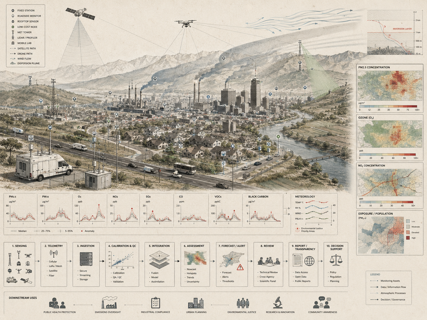
What Are Air Quality Monitoring Systems?
Air quality monitoring systems are integrated observational systems designed to detect, record, interpret, and communicate the condition of the atmosphere with respect to pollutant concentrations and related environmental variables. They include the instruments that sense pollutants, the physical sites or platforms that host those instruments, the telemetry systems that transmit records, the calibration and quality-control routines that make measurements defensible, and the analytical frameworks that convert atmospheric signals into environmental intelligence.
These systems may include reference-grade regulatory monitoring stations; supplemental and lower-cost distributed sensor networks; mobile monitoring platforms mounted on vehicles, bicycles, drones, or carried by individuals; satellite and remote sensing systems used to infer large-scale atmospheric conditions; meteorological sensors that provide context for pollutant transport and transformation; and data platforms, air quality indices, dashboards, alert systems, regulatory repositories, and modeling environments. EPA’s Air Quality System functions as a major repository for U.S. ambient air quality data used in assessments, designations, modeling, and reporting, while AirNow communicates current and forecast air quality information through the Air Quality Index. OpenAQ provides a global open-access platform for harmonized ambient air quality data, and international programmes such as WMO Global Atmosphere Watch and UNEP GEMS Air support broader atmospheric-composition and air-quality monitoring capacity.
The purpose of these systems is not only to collect measurements, but to create a reliable basis for interpretation across time and space. Polluted air is often invisible, transient, chemically complex, and spatially uneven. It cannot be governed effectively through anecdote or impression alone. Air quality monitoring systems make atmospheric conditions legible by embedding measurement within protocols of calibration, comparison, interpretation, communication, and public accountability. They are therefore better understood as observational infrastructures than as isolated devices.
| Monitoring Form | Primary Question | Typical Evidence | Main Risk |
|---|---|---|---|
| Reference-grade regulatory monitoring | Are pollutant concentrations meeting formal standards or guideline-relevant thresholds? | Validated instruments, audited sites, regulatory methods, long-term records | Spatially sparse stations may miss localized exposure gradients. |
| Supplemental sensor networks | How do pollutant concentrations vary across neighborhoods, corridors, or microenvironments? | Lower-cost sensors, collocation results, dense spatial data, correction models | Sensor drift, humidity effects, and cross-sensitivity can undermine credibility. |
| Mobile monitoring | Where are hotspots, gradients, and localized exposure patterns concentrated? | Vehicle, bicycle, drone, or handheld transects with georeferenced measurements | Short sampling windows may be mistaken for stable spatial patterns. |
| Remote sensing | What regional or transboundary atmospheric patterns are visible from above? | Satellite retrievals, aerosol optical depth, trace-gas products, plume mapping | Remote products require validation and may not resolve local exposure. |
| Community monitoring | Which local concerns, lived exposure patterns, and under-monitored burdens need visibility? | Community sensor networks, participatory data, local siting knowledge, advocacy records | Evidence can be dismissed if validation and uncertainty are not documented. |
| Integrated decision-support platforms | How can observations, models, health thresholds, maps, and alerts inform action? | Dashboards, AQI feeds, exposure maps, forecasts, public advisories | Communication may oversimplify or hide pollutant-specific uncertainty. |
This broader systems view connects air quality monitoring to weather sensing, environmental sensor networks, remote sensing, edge computing, environmental data platforms, and climate early warning. Each contributes to the wider task of making environmental conditions measurable, comparable, and actionable.
Why Air Quality Monitoring Matters
Air quality monitoring matters because air pollution is at once an environmental, epidemiological, infrastructural, and political problem. Pollutant concentrations shift with emissions, traffic, combustion sources, industrial activity, wildfire smoke, topography, seasonal cycles, atmospheric chemistry, and weather. The result is a dynamic field of risk in which conditions can vary substantially between regions, within cities, and even between adjacent streets. Monitoring creates the empirical basis needed to detect those variations and distinguish routine atmospheric fluctuation from dangerous or persistent pollution burdens.
Without monitoring, harmful conditions may remain statistically obscured, geographically underrepresented, or institutionally ignored. Long-term monitoring establishes baselines and trends. High-frequency observation reveals episodic events. Spatially distributed networks expose local hotspots that city-wide averages may conceal. This matters not only for environmental management, but also for public health. The World Health Organization’s global air quality guidelines address particulate matter, ozone, nitrogen dioxide, sulfur dioxide, and carbon monoxide, and air-quality communication systems such as the AQI translate pollutant evidence into public-health guidance. But exposure cannot be estimated meaningfully without observational systems capable of tracking pollutant concentrations across time and place.
Monitoring also matters because air quality is never only about air. It is entangled with transport systems, land use, industrial siting, energy policy, building conditions, wildfire management, climate change, housing, labor, schools, hospitals, and social inequality. Air quality monitoring systems provide one of the few mechanisms through which these cross-domain interactions can be rendered measurable. They allow institutions to assess interventions, issue advisories, guide regulation, support research, and confront the uneven geography of environmental risk.
| Need | Monitoring Contribution | Risk Without Strong Monitoring |
|---|---|---|
| Public-health protection | Supports advisories, AQI communication, exposure reduction, and vulnerable-population guidance. | People encounter harmful air without timely or understandable risk information. |
| Regulatory compliance | Provides defensible records for standards, designations, reporting, and enforcement. | Pollution control depends on incomplete or weakly documented evidence. |
| Hotspot detection | Reveals localized burdens near roads, ports, industrial corridors, warehouses, and combustion sources. | Area-wide averages conceal intense neighborhood-scale exposure. |
| Environmental justice | Documents uneven exposure and supports community claims, policy review, and corrective action. | Marginalized communities remain under-observed and under-protected. |
| Intervention evaluation | Assesses whether traffic, energy, industrial, planning, or emissions policies reduce concentrations. | Policy success or failure becomes difficult to measure. |
| Wildfire and episodic response | Supports short-term warnings and public guidance during smoke, inversions, dust, or industrial events. | Acute exposure events are detected too late or communicated poorly. |
| Public accountability | Creates evidence that can be inspected, shared, challenged, and used in public debate. | Atmospheric harm remains invisible or contestable without empirical grounding. |
Air quality monitoring matters because clean air is experienced locally, governed institutionally, and measured through systems. Where the systems are weak, the harm can remain invisible.
Air Quality Monitoring as Epistemic and Governance Infrastructure
A rigorous understanding of air quality monitoring requires moving beyond the idea that monitoring simply collects data. Monitoring systems are epistemic infrastructures: they organize how atmospheric knowledge is produced, stabilized, and made authoritative. They determine what counts as evidence, which forms of variation are detectable, what kinds of uncertainty are tolerated, and which spatial or temporal scales become administratively visible.
This epistemic role has direct governance implications. Regulatory thresholds, compliance determinations, health advisories, zoning decisions, transport interventions, wildfire-smoke guidance, industrial permitting, school exposure concerns, and environmental justice claims all depend on monitoring architectures that define where and how pollutant concentrations are observed. A monitor placed near a roadway tells a different story than a monitor placed farther from traffic. A sparse regional network produces a different visibility regime than a dense neighborhood-scale network. A system optimized for annual averages will illuminate different dynamics than one designed to capture short-lived pollution spikes.
Air quality monitoring systems are therefore not neutral windows onto atmospheric reality. They are designed arrangements of instruments, standards, models, communication protocols, and institutions. Good systems improve environmental visibility, comparability, and accountability. Weak systems can obscure local burdens, understate episodic risk, or create false confidence in coarse averages. To monitor air well is not simply to deploy sensors. It is to design an observational regime adequate to the environmental, institutional, and ethical stakes of polluted air.
| Monitoring Choice | What Becomes More Visible | What May Remain Less Visible |
|---|---|---|
| Regional reference stations | Long-term regulatory trends, compliance records, broad background conditions. | Street-level gradients, localized industrial exposure, neighborhood hotspots. |
| Dense low-cost sensor networks | Fine-grained spatial variation, community concerns, local events. | Reference-grade comparability if calibration and validation are weak. |
| Mobile monitoring | Roadway gradients, industrial plumes, block-scale variation, transient hotspots. | Long-term temporal comparability without repeat sampling design. |
| Satellite observation | Regional patterns, wildfire plumes, transboundary transport, large-scale aerosols. | Near-surface exposure and local microenvironments without ground validation. |
| AQI communication | Publicly understandable health-risk categories and action guidance. | Pollutant-specific detail, uncertainty, and local exposure inequality. |
| Community monitoring | Lived exposure concerns, under-monitored places, and local accountability. | Formal legitimacy if methods, metadata, and uncertainty are not transparent. |
Air quality monitoring is powerful because it turns invisible atmospheric harm into evidence. It is risky when the design of that evidence system hides the people and places most exposed.
Core Pollutants and Measurement Targets
Air quality monitoring systems are typically organized around pollutants with established relevance to public health, ecosystems, atmospheric chemistry, or climate interactions. These pollutants may be measured directly, inferred from correlated signals, retrieved from remote sensing, or interpreted through a combination of sensing and modeling approaches. Their significance depends on concentration, duration, chemical behavior, exposure pathways, vulnerable populations, and context.
| Pollutant / Indicator | Why It Matters | Monitoring Challenge | Interpretive Context |
|---|---|---|---|
| PM2.5 | Fine particles penetrate deeply into the respiratory system and are strongly associated with serious health burdens. | Particle composition, humidity effects, wildfire smoke, sensor correction, and source mixture complexity. | Long-term exposure, short-term spikes, wildfire smoke, combustion sources, indoor-outdoor exchange. |
| PM10 | Coarser particles affect respiratory health and are relevant to dust, roads, construction, agriculture, and industrial activity. | Local resuspension, meteorology, and spatially uneven sources. | Dust events, construction corridors, roadways, dryland conditions, occupational settings. |
| Ozone (O3) | A secondary pollutant formed through photochemical reactions involving precursor emissions and sunlight. | Not emitted directly; depends on NOx, VOCs, sunlight, heat, transport, and chemistry. | Regional formation, heat events, photochemical smog, downwind exposure. |
| Nitrogen dioxide (NO2) | Closely associated with combustion, traffic, industrial activity, and respiratory risk. | Sharp near-road gradients and temporal variability. | Traffic corridors, ports, freight networks, combustion sources, street canyons. |
| Sulfur dioxide (SO2) | Linked to fossil fuel combustion, shipping, industrial operations, and certain point sources. | Plume behavior and source-proximate variation. | Industrial corridors, power generation, shipping, volcanic events in some regions. |
| Carbon monoxide (CO) | Produced by incomplete combustion and important in traffic, fire, and enclosed or semi-enclosed exposure contexts. | Spatial and source-specific variation; health relevance depends on exposure context. | Transport, combustion, wildfire smoke, parking structures, indoor-outdoor interaction. |
| Volatile organic compounds (VOCs) | Direct pollutants and precursors in ozone and secondary aerosol formation. | Diverse chemical species, source complexity, instrument specificity, and sampling methods. | Industrial emissions, solvents, fuels, vegetation, indoor sources, photochemistry. |
| Black carbon and aerosol indicators | Important for combustion-source tracking, exposure inequality, and climate-forcing connections. | Measurement method differences and source attribution complexity. | Diesel corridors, biomass burning, urban combustion, climate-air interactions. |
Pollutant monitoring is not analytically meaningful in isolation. Concentrations must be interpreted alongside meteorological variables such as wind speed, wind direction, humidity, temperature, precipitation, atmospheric stability, boundary-layer height, and solar radiation. Pollutants move, transform, disperse, and accumulate within atmospheric systems. Air quality monitoring is therefore best understood as atmospheric systems observation rather than simple pollutant counting.
Key Analytical Distinctions
Monitoring is not the same as exposure assessment. Monitoring systems measure environmental concentrations at particular locations, intervals, and scales. Exposure assessment asks how those concentrations relate to what people actually inhale across daily movement, indoor-outdoor transitions, occupational settings, transportation corridors, housing conditions, or cumulative vulnerability. Monitoring informs exposure assessment, but does not by itself resolve it.
Concentration measurement is not the same as source attribution. A monitor can identify elevated pollutant levels without fully determining which sources produced them. Source attribution may require emissions inventories, chemical speciation, dispersion modeling, receptor modeling, wind-field analysis, comparative siting, or repeated sampling. Monitoring often reveals that a problem exists before it definitively explains why it exists.
Monitoring is not identical to forecasting. Monitoring measures present or past atmospheric conditions. Forecasting attempts to estimate future conditions using models, meteorological data, historical patterns, and real-time inputs. The two functions are related, but they serve different decision purposes and involve different uncertainties.
Measurement uncertainty is not the same as policy uncertainty. A monitoring system may produce technically acceptable measurements while policymakers remain uncertain about which interventions are most effective or politically feasible. Conversely, policy goals may be clear while the observational system remains too sparse or noisy to support confident action. Air governance must often operate across both forms of uncertainty at once.
Fixed-site, mobile, and remote monitoring generate different kinds of knowledge. Fixed stations provide continuity and comparability. Mobile systems provide spatial granularity. Remote sensing provides broad context. Community sensors can reveal local concern and fill visibility gaps. Each mode has distinct strengths, limitations, and interpretive roles. Robust monitoring architectures usually emerge from integration rather than reliance on a single observational form.
| Distinction | Why It Matters | Design Implication |
|---|---|---|
| Monitoring versus exposure assessment | Ambient measurements do not automatically represent human exposure. | Link concentration records to population, mobility, indoor-outdoor, and vulnerability context. |
| Measurement versus source attribution | Elevated concentrations do not automatically identify source responsibility. | Use emissions inventories, meteorology, chemical speciation, and source-oriented design. |
| Monitoring versus forecasting | Observed conditions and predicted conditions have different uncertainty structures. | Separate real-time measurements, forecast products, warning logic, and valid-use caveats. |
| Regulatory monitoring versus community monitoring | Formal defensibility and local visibility often require different network designs. | Integrate reference-grade anchors with validated supplemental networks where appropriate. |
| Sensor count versus evidence quality | Dense networks can be misleading without calibration, metadata, and QC. | Track collocation, drift, completeness, correction method, and uncertainty. |
| AQI communication versus pollutant-specific evidence | Indices simplify public messaging but can hide pollutant-specific details. | Pair public index values with pollutant data, caveats, and vulnerable-population guidance. |
These distinctions prevent air quality monitoring from being reduced to dashboards or sensors. The system’s purpose is to produce trustworthy atmospheric evidence that can support health protection, public accountability, and environmental action.
System Architecture: From Sensor to Decision
Air quality monitoring systems usually function as layered observational architectures that connect field measurement to institutional interpretation and action. Pollutants are measured through fixed monitors, distributed sensors, mobile platforms, or remote sensing systems. Signals are sampled, digitized, time-stamped, georeferenced, and transmitted through telemetry infrastructures. Measurements are associated with platform metadata, siting context, meteorological conditions, calibration history, and quality-control flags. Processing pipelines clean, correct, validate, aggregate, and align measurements with reference standards. Analytical systems identify trends, anomalies, exceedances, hotspots, and exposure gradients. Communication systems translate evidence into dashboards, air quality indices, alerts, maps, reports, and advisories. Agencies, researchers, communities, and decision-makers then use the information for enforcement, public health, planning, intervention, and evaluation.
| Stage | Transformation | Failure Risk |
|---|---|---|
| Atmospheric process | Emissions, chemistry, meteorology, and transport create pollutant fields. | The monitoring design does not match the pollutant behavior or decision question. |
| Observation | Fixed, mobile, distributed, or remote systems measure pollutant-related signals. | Instrument readings are overgeneralized beyond their valid-use context. |
| Acquisition | Signals are digitized, timestamped, georeferenced, and linked to platform metadata. | Measurements lose interpretability without timing, location, or instrument context. |
| Transmission | Data move through wired, cellular, radio, satellite, or hybrid telemetry systems. | Latency, outage, or incomplete reporting weakens real-time use. |
| Calibration and QC | Measurements are corrected, validated, flagged, compared, and screened for quality. | Bad data are communicated, or valid extreme events are wrongly rejected. |
| Contextualization | Meteorology, land use, population, source proximity, and vulnerability data are integrated. | Concentrations are interpreted without exposure or atmospheric context. |
| Analysis | Systems detect trends, anomalies, exceedances, hotspots, exposure gradients, and intervention effects. | Statistics hide uncertainty, missingness, or representativeness limits. |
| Communication and action | Evidence becomes dashboards, indices, alerts, reports, enforcement, planning, and public-health guidance. | Data are visible but not actionable, trusted, or equitably interpreted. |
This architecture reveals why technically sophisticated sensors can still produce weak monitoring outcomes. Poor siting, inconsistent maintenance, limited contextual data, opaque processing pipelines, inadequate interpretive frameworks, or inaccessible public communication can all degrade the system. Air quality monitoring succeeds when the full chain from measurement to communication is coherent, transparent, and fit for purpose.
Monitoring Technologies and Network Types
Air quality monitoring technologies vary in precision, scale, cost, latency, spatial density, and intended use. Their differences are not merely technical; they reflect distinct observational logics and institutional purposes.
Reference-grade regulatory stations are designed for high reliability, comparability, and formal decision use. They generally operate under standardized siting requirements, validated instrumentation, established quality-assurance routines, and regulatory reporting protocols. Their strength lies in producing defensible measurements for compliance, trend analysis, and public reporting over long periods.
Research monitoring networks are often optimized for scientific questions that extend beyond compliance, such as atmospheric chemistry, transport dynamics, source differentiation, aerosol composition, exposure pathways, or model evaluation. These systems may combine high-quality instruments with experimental designs that prioritize causal inference or process understanding.
Community and supplemental sensor networks often rely on lower-cost devices to improve spatial coverage, reveal neighborhood-scale variation, and make air pollution more publicly visible. These networks are especially important where official monitoring is sparse, but their value depends heavily on validation, calibration, contextual interpretation, and transparent communication about limitations. EPA’s Air Sensor Toolbox provides authoritative guidance on performance, evaluation, and appropriate use of air sensor technologies.
Mobile monitoring platforms mounted on vehicles, bicycles, drones, or personal devices capture high-resolution spatial variability that fixed stations may miss. They are particularly useful for identifying near-road exposures, industrial gradients, port and freight corridors, warehouse clusters, and localized hotspots, though they require careful repeat sampling and contextual interpretation.
Remote sensing systems provide broad spatial perspective and can illuminate regional patterns, transboundary transport, wildfire plumes, dust events, and large-scale aerosol dynamics. However, remotely sensed products usually require integration with ground-based observations for validation and local interpretability. They do not replace surface monitoring so much as extend its observational reach.
| Technology / Network Type | Primary Strength | Best Use | Main Limitation |
|---|---|---|---|
| Reference-grade station | Defensible, standardized, long-term measurement. | Regulatory reporting, trend analysis, compliance assessment, public records. | Sparse networks may miss local hotspots. |
| Supplemental low-cost sensor | Higher spatial density and lower deployment cost. | Community monitoring, hotspot screening, neighborhood-scale mapping. | Requires collocation, correction, drift management, and uncertainty caveats. |
| Mobile platform | Fine-grained spatial mapping. | Near-road gradients, industrial plumes, port corridors, urban microenvironments. | Temporal comparability requires repeat sampling design. |
| Satellite product | Regional and transboundary atmospheric visibility. | Wildfire smoke, dust, aerosol patterns, trace-gas context, data-sparse regions. | Surface exposure and local concentration require ground validation. |
| Meteorological co-monitoring | Explains transport, dispersion, chemistry, and accumulation. | Source interpretation, plume tracking, forecasting, inversion analysis. | Often under-integrated into public dashboards. |
| Integrated data platform | Combines observations, models, maps, alerts, and decision workflows. | Public communication, agency workflows, intervention evaluation. | Can hide method differences if provenance is weak. |
The strongest air quality monitoring systems are usually hybrid systems. Fixed reference stations provide continuity; distributed sensors increase spatial density; mobile platforms map micro-variation; satellite systems expand scale; and meteorological data explain atmospheric behavior. Together these modes create a layered picture of polluted air that no single instrument class can provide on its own.
Calibration, Validation, and Data Quality
Data quality is one of the defining challenges of air quality monitoring because atmospheric measurements are shaped by instrument design, chemical interference, environmental conditions, maintenance practices, site characteristics, and processing choices. Low-cost sensors may exhibit drift, humidity sensitivity, temperature effects, cross-sensitivity, nonlinear response, or pollutant-specific performance differences. Even reference systems require routine calibration, auditing, maintenance, and procedural consistency to preserve comparability.
For this reason, calibration and validation are not peripheral technical tasks. They are constitutive elements of the monitoring system itself. A network cannot be treated as trustworthy merely because it is dense or technologically novel. Good monitoring requires initial calibration, recalibration over time, collocation with reference instruments where feasible, instrument drift detection, fault management, data completeness review, temporal representativeness assessment, cross-sensitivity testing, siting documentation, metadata preservation, and transparent processing workflows.
A research-grade treatment must also stress that data quality is inseparable from interpretive quality. Measurements may be technically sound but analytically misleading if used at inappropriate time scales, interpreted without meteorological context, or communicated without clear uncertainty boundaries. The aim is not maximal data volume, but trustworthy atmospheric evidence that remains legible across scientific, regulatory, and civic contexts.
| Practice | Purpose | Evidence Artifact | Failure Risk |
|---|---|---|---|
| Reference collocation | Compares sensor behavior against a trusted reference system. | Collocation report, correction model, performance summary. | Low-cost sensor values are used without known accuracy limits. |
| Calibration and recalibration | Maintains measurement comparability over time. | Calibration log, maintenance record, instrument history. | Sensor drift is mistaken for changing air quality. |
| Completeness review | Ensures the record is adequate for time-window analysis or public reporting. | Expected versus valid observation report. | Missing data hide events or bias averages. |
| Environmental correction | Addresses humidity, temperature, and co-pollutant effects. | Correction method, validation dataset, caveat statement. | Meteorological artifacts appear as pollutant changes. |
| Siting documentation | Clarifies what environment the monitor represents. | Siting rationale, source-proximity note, photos, metadata. | Readings are overgeneralized beyond their spatial context. |
| QC flagging | Separates valid, suspect, provisional, corrected, and excluded observations. | QC policy, flag table, audit trail. | Users cannot distinguish trustworthy from questionable data. |
| Uncertainty communication | Explains limits of instruments, models, coverage, and interpretation. | Public caveat, uncertainty statement, valid-use note. | Maps and dashboards appear more certain than the evidence supports. |
Air quality data become trustworthy when quality practices are visible. A monitoring network that cannot explain its calibration, QC, siting, and uncertainty is not yet a robust evidence system.
Analytics, Forecasting, and Decision Support
Air quality monitoring systems increasingly function not only as measurement systems but as analytical and decision-support systems. Once collected and quality-checked, observations can be integrated into geospatial dashboards, atmospheric dispersion models, chemical transport models, trend analyses, exposure estimates, warning systems, and intervention assessment frameworks.
These analytical uses may include identifying recurring hotspots and spatial inequalities; detecting exceedances, anomalies, and episodic pollution events; estimating population exposure patterns and vulnerability burdens; supporting source interpretation through combined observational and modeling methods; evaluating interventions such as traffic restrictions, emissions controls, clean-port strategies, industrial permitting, zoning changes, or building filtration guidance; supporting short-term forecasting during wildfire smoke, inversions, dust storms, or heat-related ozone episodes; and integrating air monitoring with broader environmental intelligence systems.
Decision support depends on translation. Raw concentrations may be scientifically meaningful yet difficult for non-specialists to interpret. Air quality indices, maps, advisories, and dashboards convert atmospheric measurements into operational signals for governments, schools, hospitals, workers, households, and the public. This translation is not trivial. Oversimplification can obscure uncertainty; over-technical presentation can limit usefulness. Good systems communicate risk in ways that are both scientifically responsible and socially actionable.
| Use Case | Monitoring Input | Decision Output | Evidence Risk |
|---|---|---|---|
| AQI and public advisories | Validated pollutant concentrations and forecast guidance. | Health-risk categories, outdoor activity guidance, alerts. | Index values can hide pollutant-specific or vulnerable-population detail. |
| Hotspot mapping | Dense sensors, mobile monitoring, reference anchors, geospatial context. | Priority locations for mitigation, enforcement, or further study. | Short sampling periods can be overinterpreted. |
| Wildfire-smoke response | PM2.5 sensors, satellite plumes, meteorology, forecasts. | Public-health guidance, school decisions, sheltering and filtration advice. | Rapidly changing smoke fields can outpace sparse networks. |
| Regulatory review | Reference-grade monitoring records and data-quality documentation. | Compliance determinations, designations, reporting, enforcement review. | Formal networks may not represent local exposure burdens. |
| Environmental justice assessment | Pollutant maps, population vulnerability, source proximity, community data. | Equity review, mitigation prioritization, public accountability. | Weak validation can allow real burdens to be dismissed. |
| Intervention evaluation | Before-after records, source context, meteorology, control comparison. | Assessment of traffic, industrial, energy, or planning interventions. | Weather and background trends may be mistaken for policy effects. |
From a systems perspective, monitoring becomes most valuable when it is connected to choices: how to warn, where to intervene, which communities to prioritize, and whether an environmental strategy is working.
Governance, Equity, and the Politics of Visibility
Air quality monitoring is unavoidably political because it structures environmental visibility. Decisions about where monitors are located, which pollutants are emphasized, what averaging periods are used, and how results are communicated all influence whose exposure becomes visible and whose remains statistically marginalized. A sparse city-wide network may suggest acceptable averages while masking severe burdens near roads, ports, warehouses, industrial corridors, freight routes, airports, power plants, or other concentrated sources.
This makes air quality monitoring central to environmental justice. Pollution burdens are often distributed unequally across neighborhoods shaped by historical disinvestment, industrial zoning, highway construction, housing discrimination, labor exposure, transport infrastructure, or weak regulatory protection. Monitoring systems that lack spatial granularity may understate those inequalities. More distributed monitoring, when carefully validated and interpreted, can reveal patterns of localized harm that official networks may miss.
There is also a politics of interpretation. Monitoring data can be used to justify enforcement, support community advocacy, guide public-health advisories, or frame policy debate. But data can also be contested through arguments about uncertainty, representativeness, or causation. Strong monitoring systems therefore require both technical credibility and institutional legitimacy. They must be transparent about limitations while still producing actionable evidence. In this sense, the purpose of monitoring is not only to measure pollution, but to make atmospheric harm governable and publicly discussable.
| Dimension | Governance Question | Evidence Needed | Failure Risk |
|---|---|---|---|
| Siting equity | Are monitors located where exposure burdens are likely to occur? | Siting rationale, source-proximity map, vulnerability layer. | Networks underrepresent high-burden communities. |
| Pollutant prioritization | Are monitored pollutants aligned with local sources and health concerns? | Emissions inventory, community concerns, pollutant rationale. | Important pollutants remain unmeasured or invisible. |
| Data accessibility | Can communities, researchers, and institutions access usable data? | Open data feed, documentation, license, API, plain-language guidance. | Evidence exists but remains inaccessible or technically unusable. |
| Interpretive legitimacy | Are methods transparent enough to withstand public scrutiny? | Calibration records, QC flags, uncertainty statements, public evidence package. | Monitoring claims are dismissed or misused. |
| Community participation | Are local knowledge and community monitoring integrated responsibly? | Participatory design record, validation workflow, community review notes. | Community evidence is excluded or tokenized. |
| Action accountability | Does monitoring lead to mitigation, enforcement, planning, or health protection? | Decision log, intervention record, follow-up monitoring, public response tracker. | Monitoring documents harm without changing conditions. |
Open-data initiatives matter in this context because visibility, access, and comparability are not only technical questions but public ones. Systems that are difficult to access or interpret can reinforce institutional asymmetries in who gets to know what about polluted air.
Future Directions
The future of air quality monitoring lies in deeper integration across scales, technologies, and institutional functions. Lower-cost sensing is increasing spatial resolution. Edge computation is enabling more distributed and responsive deployments. Mobile and wearable monitoring are expanding fine-grained mapping of urban exposure. Satellite observation continues to improve regional visibility. Data platforms increasingly combine regulatory, community, meteorological, satellite, and modeled information into unified analytical environments.
Yet the most important future challenge is not simply technical expansion. It is building monitoring systems that are interoperable, explainable, validated, and useful across public health, climate, planning, infrastructure, labor, education, and governance domains. Future systems will need to support not only pollutant detection, but also uncertainty communication, source interpretation, exposure estimation, equity analysis, wildfire response, neighborhood-scale decision-making, and long-horizon trend assessment. They will need stronger connections to environmental dashboards, resilience systems, emergency warning infrastructures, air-quality management plans, and broader sustainability governance.
Artificial intelligence and machine learning will increasingly affect sensor correction, anomaly detection, source interpretation, data fusion, plume mapping, exposure estimation, and forecasting. These tools may improve pattern recognition and operational speed, but they also increase the need for provenance, validation, bias review, uncertainty communication, and governance. A fast model trained on uneven monitoring data can reproduce observational inequality at computational speed.
Air quality monitoring is therefore evolving from a specialized environmental function into a foundational component of urban, regional, and public-health intelligence. As atmospheric risks become more entangled with wildfire, heat, traffic, industrial transition, indoor air, energy systems, and climate adaptation, the ability to monitor air quality well will increasingly shape how societies define environmental responsibility, protect health, and govern ecological change.
Deployment Readiness Gate
Before an air quality monitoring system is used for public alerts, regulatory reporting, community exposure claims, environmental justice assessment, intervention evaluation, public-health guidance, or planning decisions, it should pass a deployment readiness gate. This gate should test whether the system is pollutant-appropriate, spatially meaningful, calibrated, quality-controlled, meteorologically contextualized, exposure-aware, uncertainty-transparent, and governance-aligned.
| Readiness Area | Required Question | Pass Evidence |
|---|---|---|
| Purpose readiness | Does the system define pollutant targets, geography, population, time scale, monitoring purpose, and decision use? | Monitoring objective manifest, pollutant rationale, decision-use statement |
| Network readiness | Are monitor locations, platform types, sensor density, and hotspot-coverage decisions justified? | Siting rationale, network map, platform registry, coverage audit |
| Calibration readiness | Are reference comparisons, collocation studies, correction models, and recalibration routines documented? | Calibration log, collocation report, validation record |
| Quality-control readiness | Are data completeness, drift, humidity, cross-sensitivity, outliers, and sensor faults handled? | QC policy, flag table, completeness report, maintenance log |
| Context readiness | Are meteorology, source proximity, land use, and temporal patterns integrated into interpretation? | Meteorological table, source-context layer, model card |
| Exposure readiness | Can concentration data be interpreted in relation to people, places, vulnerability, and microenvironments? | Exposure layer, population-at-risk table, vulnerable-population caveat |
| Communication readiness | Are dashboards, AQI outputs, alerts, maps, and reports clear, accurate, and uncertainty-aware? | Dashboard specification, alert protocol, public evidence package |
| Equity readiness | Are high-burden communities, near-source exposure zones, and under-monitored areas represented? | Environmental justice audit, siting equity review, community-monitoring integration plan |
| Governance readiness | Are data stewardship, public access, intervention review, uncertainty, and corrective actions documented? | Governance log, open-data policy, intervention evaluation, corrective-action tracker |
This readiness gate prevents air quality monitoring from being treated as complete merely because sensors or dashboards exist. The stronger standard is whether the system can produce credible, spatially meaningful, health-relevant, and publicly accountable atmospheric evidence.
Data and Configuration Artifacts
A reproducible air-quality monitoring workflow should include explicit artifacts for objectives, sensors, siting, observations, calibration, quality control, meteorology, exposure, communication, intervention, equity, and governance. These artifacts make air-quality claims auditable rather than hidden inside dashboards, maps, device feeds, or public statements.
| Artifact | Purpose | Suggested Path |
|---|---|---|
| Air quality monitoring objective manifest | Defines pollutant targets, geography, population, time scale, monitoring purpose, and decision use. | config/air_quality_monitoring_objective.yml |
| Sensor and platform registry | Stores instrument class, owner, location, pollutant targets, method, update frequency, and valid-use caveats. | data/air_quality_sensor_registry.csv |
| Siting and network rationale | Documents why monitors were placed where they were and which exposure questions they support. | docs/siting_network_rationale.md |
| Pollutant observation records | Stores concentration values, units, timestamps, platform IDs, QC flags, and observation context. | data/pollutant_observation_records.csv |
| Calibration and collocation log | Tracks reference comparison, correction models, drift review, maintenance, and validation status. | data/calibration_collocation_log.csv |
| Quality-control flag table | Documents missingness, outliers, drift, humidity correction, cross-sensitivity, and exclusion rules. | data/air_quality_qc_flags.csv |
| Meteorological context table | Links pollutant observations to wind, humidity, temperature, stability, and dispersion conditions. | data/meteorological_context.csv |
| Exposure and equity layer | Links monitoring data to population, vulnerability, schools, hospitals, roads, industry, and source proximity. | data/exposure_equity_layer.csv |
| Dashboard and alert specification | Defines public communication, AQI logic, thresholds, maps, caveats, and advisory rules. | docs/dashboard_alert_specification.md |
| Governance and intervention log | Tracks decisions, advisories, enforcement, mitigation, public access, and corrective actions. | data/air_quality_governance_log.csv |
These artifacts turn air quality monitoring into a reproducible atmospheric evidence system rather than a loose collection of sensors, dashboards, and public claims.
Mathematical Lens: Concentration, Exposure, Coverage, Calibration, and Evidence Quality
Several simple metrics can help evaluate air-quality monitoring readiness. These metrics are not substitutes for atmospheric chemistry, regulatory methods, epidemiology, or environmental justice analysis, but they make evidence quality more inspectable.
E = \sum_i C_i \times T_i
\]
Interpretation: Exposure depends on pollutant concentration across the places and time periods where people actually spend time, not on a single ambient measurement alone.
C_{\mathrm{mean}} =
\frac{1}{n}\sum_{t=1}^{n} C_t
\]
Interpretation: Mean concentration summarizes pollutant values over a defined averaging period. The averaging period must be explicit.
D_{\mathrm{complete}} =
\frac{N_{\mathrm{valid}}}{N_{\mathrm{expected}}}
\]
Interpretation: Data completeness measures the share of expected observations that pass validity requirements.
C_{\mathrm{network}} =
\frac{A_{\mathrm{represented}}}{A_{\mathrm{target}}}
\]
Interpretation: Network coverage compares the monitored or represented area against the intended target domain, while recognizing that near-source gradients may require finer spatial analysis.
Q_{\mathrm{air\ evidence}} =
w_1K_q +
w_2D_c +
w_3S_c +
w_4T_c +
w_5M_x +
w_6E_r +
w_7U_c +
w_8G_r
\]
Interpretation: Air-quality evidence depends on calibration quality, data completeness, spatial coverage, temporal coverage, meteorological context, exposure relevance, uncertainty communication, and governance readiness.
These measures evaluate air quality monitoring as an atmospheric evidence system. They ask whether pollutant measurements are calibrated, complete, spatially meaningful, temporally adequate, meteorologically contextualized, exposure-relevant, uncertainty-aware, and governance-ready enough to support the claim being made.
Python Workflow: Air Quality Monitoring Readiness and Evidence-Quality Scoring
A Python workflow can demonstrate how air quality monitoring programs might be evaluated for calibration quality, data completeness, spatial coverage, temporal coverage, meteorological context, exposure relevance, uncertainty communication, and governance readiness. The purpose is not to create a universal air-quality score, but to make evidence-quality dimensions visible.
from dataclasses import dataclass
from typing import List
import pandas as pd

@dataclass
class AirQualityMonitoringProgram:
    program_id: str
    monitoring_purpose: str
    geography: str
    pollutant_focus: str
    calibration_quality: float
    data_completeness: float
    spatial_coverage: float
    temporal_coverage: float
    meteorological_context: float
    exposure_relevance: float
    uncertainty_communication: float
    governance_readiness: float
    high_stakes_use: bool

def air_evidence_quality(program: AirQualityMonitoringProgram) -> float:
    return (
        0.15 * program.calibration_quality +
        0.14 * program.data_completeness +
        0.13 * program.spatial_coverage +
        0.12 * program.temporal_coverage +
        0.12 * program.meteorological_context +
        0.13 * program.exposure_relevance +
        0.10 * program.uncertainty_communication +
        0.11 * program.governance_readiness
    )

def classify_review_priority(program: AirQualityMonitoringProgram, score: float) -> str:
    if program.high_stakes_use and program.calibration_quality < 0.75:
        return "high_stakes_calibration_review"
    if program.data_completeness < 0.75:
        return "data_completeness_review"
    if program.spatial_coverage < 0.70:
        return "spatial_coverage_review"
    if program.temporal_coverage < 0.75:
        return "temporal_coverage_review"
    if program.meteorological_context < 0.70:
        return "meteorological_context_review"
    if program.exposure_relevance < 0.70:
        return "exposure_relevance_review"
    if program.uncertainty_communication < 0.75:
        return "uncertainty_communication_review"
    if program.governance_readiness < 0.75:
        return "governance_readiness_review"
    if score < 0.75:
        return "air_evidence_quality_review"
    return "routine_monitoring"

programs: List[AirQualityMonitoringProgram] = [
    AirQualityMonitoringProgram(
        "reference-regulatory-network",
        "compliance_and_long_term_trends",
        "regional_air_district",
        "PM2.5_O3_NO2_SO2_CO",
        0.92,
        0.88,
        0.70,
        0.86,
        0.78,
        0.72,
        0.82,
        0.86,
        True,
    ),
    AirQualityMonitoringProgram(
        "community-sensor-network",
        "neighborhood_hotspot_visibility",
        "near_road_and_industrial_corridors",
        "PM2.5_NO2",
        0.72,
        0.80,
        0.86,
        0.78,
        0.72,
        0.82,
        0.74,
        0.76,
        True,
    ),
    AirQualityMonitoringProgram(
        "mobile-monitoring-program",
        "spatial_gradient_mapping",
        "urban_freight_and_port_corridors",
        "NO2_black_carbon_PM2.5",
        0.78,
        0.70,
        0.88,
        0.66,
        0.76,
        0.84,
        0.72,
        0.74,
        True,
    ),
    AirQualityMonitoringProgram(
        "wildfire-smoke-monitoring",
        "public_health_advisory",
        "regional_smoke_exposure_zone",
        "PM2.5",
        0.80,
        0.76,
        0.74,
        0.82,
        0.84,
        0.76,
        0.78,
        0.80,
        True,
    ),
]

records = []
for program in programs:
    score = air_evidence_quality(program)
    records.append({
        "program_id": program.program_id,
        "monitoring_purpose": program.monitoring_purpose,
        "geography": program.geography,
        "pollutant_focus": program.pollutant_focus,
        "calibration_quality": program.calibration_quality,
        "data_completeness": program.data_completeness,
        "spatial_coverage": program.spatial_coverage,
        "temporal_coverage": program.temporal_coverage,
        "meteorological_context": program.meteorological_context,
        "exposure_relevance": program.exposure_relevance,
        "uncertainty_communication": program.uncertainty_communication,
        "governance_readiness": program.governance_readiness,
        "air_evidence_quality": round(score, 3),
        "review_priority": classify_review_priority(program, score),
    })

df = pd.DataFrame(records)
print(df.sort_values(["review_priority", "air_evidence_quality"]))
This workflow treats air quality monitoring programs as atmospheric evidence systems. A program is not ready merely because it has sensors, maps, or pollutant readings. It must preserve enough evidence about calibration, completeness, coverage, meteorological context, exposure relevance, uncertainty, and governance to support the intended claim.
R Workflow: Air Quality Monitoring Coverage, Exposure, and Governance Review
An R workflow can support air-quality governance by summarizing readiness across regulatory, community, mobile, wildfire-smoke, and integrated decision-support monitoring programs. This is useful for monitoring-network audits, public evidence packages, environmental justice review, intervention assessment, and dashboard governance.
library(dplyr)
library(readr)

air_programs <- tribble(
  ~program_id, ~monitoring_purpose, ~geography, ~pollutant_focus, ~calibration_quality, ~data_completeness, ~spatial_coverage, ~temporal_coverage, ~meteorological_context, ~exposure_relevance, ~uncertainty_communication, ~governance_readiness, ~high_stakes_use,
  "reference-regulatory-network", "compliance_and_long_term_trends", "regional_air_district", "PM2.5_O3_NO2_SO2_CO", 0.92, 0.88, 0.70, 0.86, 0.78, 0.72, 0.82, 0.86, TRUE,
  "community-sensor-network", "neighborhood_hotspot_visibility", "near_road_and_industrial_corridors", "PM2.5_NO2", 0.72, 0.80, 0.86, 0.78, 0.72, 0.82, 0.74, 0.76, TRUE,
  "mobile-monitoring-program", "spatial_gradient_mapping", "urban_freight_and_port_corridors", "NO2_black_carbon_PM2.5", 0.78, 0.70, 0.88, 0.66, 0.76, 0.84, 0.72, 0.74, TRUE,
  "wildfire-smoke-monitoring", "public_health_advisory", "regional_smoke_exposure_zone", "PM2.5", 0.80, 0.76, 0.74, 0.82, 0.84, 0.76, 0.78, 0.80, TRUE
)

air_quality_summary <- air_programs %>%
  mutate(
    air_evidence_quality = round(
      0.15 * calibration_quality +
      0.14 * data_completeness +
      0.13 * spatial_coverage +
      0.12 * temporal_coverage +
      0.12 * meteorological_context +
      0.13 * exposure_relevance +
      0.10 * uncertainty_communication +
      0.11 * governance_readiness,
      3
    ),
    review_priority = case_when(
      high_stakes_use & calibration_quality < 0.75 ~ "high_stakes_calibration_review",
      data_completeness < 0.75 ~ "data_completeness_review",
      spatial_coverage < 0.70 ~ "spatial_coverage_review",
      temporal_coverage < 0.75 ~ "temporal_coverage_review",
      meteorological_context < 0.70 ~ "meteorological_context_review",
      exposure_relevance < 0.70 ~ "exposure_relevance_review",
      uncertainty_communication < 0.75 ~ "uncertainty_communication_review",
      governance_readiness < 0.75 ~ "governance_readiness_review",
      air_evidence_quality < 0.75 ~ "air_evidence_quality_review", TRUE ~ "routine_monitoring" ) ) %>%
  arrange(review_priority, air_evidence_quality)

print(air_quality_summary)

write_csv(
  air_quality_summary,
  "outputs/air_quality_monitoring_readiness_summary.csv"
)
The R workflow emphasizes that air-quality monitoring review should account for calibration quality, data completeness, spatial coverage, temporal coverage, meteorological context, exposure relevance, uncertainty communication, and governance. These dimensions help prevent monitoring systems from being judged by sensor count or dashboard availability alone.
Systems Code: Sensors, Pollutants, Calibration, Exposure, Dashboards, and Governance Logs
Air quality monitoring depends on full-stack atmospheric data systems. The stack includes sensor registries, pollutant observation records, calibration logs, collocation datasets, quality-control flags, telemetry records, meteorological context, exposure layers, equity audits, dashboard specifications, AQI or alert rules, public evidence packages, intervention logs, and governance records. A serious companion repository should therefore include both analytical workflows and systems-code scaffolding.
| Language / Tool | Role in Companion Repository | Example Use |
|---|---|---|
| Python | Readiness scoring, QC review, calibration triage, exposure-linking, hotspot screening, and governance summaries | Air-quality evidence-quality scoring and review prioritization |
| R | Monitoring summaries, trend tables, exposure and equity reports, and public evidence outputs | Reporting-ready air-quality governance tables |
| SQL | Sensor registries, pollutant observations, calibration logs, QC flags, exposure layers, and intervention records | Auditable air-quality monitoring database schema |
| GeoJSON | Station locations, mobile routes, hotspot zones, environmental justice areas, and source proximity | Spatial registry for monitoring coverage and exposure context |
| TypeScript | Dashboard and platform data models | Sensor cards, AQI panels, map layers, alert cards, and uncertainty views |
| Go | Lightweight monitoring-status endpoint | Expose sensor, calibration, QC, telemetry, and dashboard readiness |
| Rust | Safe validation CLI for pollutant records and sensor metadata | Validate timestamps, pollutant codes, units, platform IDs, and QC flags |
| C / C++ | Low-level sensor-record and bounded queue examples | Demonstrate embedded air sensor records and alert-event queues |
| Shell scripts | Reproducible directory, validation, and export workflows | One-command scaffold validation and output generation |
This breadth is appropriate because air quality monitoring is not only pollutant sensing. It is evidence infrastructure spanning atmospheric observation, calibration, public health, environmental justice, communication, intervention, and governance.
GitHub Repository
A companion repository for this article should translate the air-quality monitoring framework into reproducible technical scaffolding. The repository should include air-quality monitoring objective manifests, sensor registries, pollutant observation records, calibration and collocation logs, quality-control flags, meteorological context tables, exposure and equity layers, readiness scoring workflows, SQL schemas, dashboard data types, and governance records.
Testing and Validation
Testing air quality monitoring systems requires more than confirming that pollutant readings exist. It requires validating sensor metadata, siting rationale, calibration status, collocation results, data completeness, unit consistency, timestamps, telemetry health, quality-control flags, meteorological context, exposure relevance, dashboard logic, public communication, and governance records. A system can appear data-rich while producing weak evidence if its measurements are poorly calibrated, weakly contextualized, spatially biased, or disconnected from public-health and governance needs.
| Test Type | Purpose | Example Test |
|---|---|---|
| Sensor metadata test | Ensure instrument class, pollutant target, location, owner, method, and valid-use caveats are documented. | Validate sensor registry fields. |
| Siting test | Ensure monitor placement matches regulatory, community, hotspot, or exposure purpose. | Review siting rationale and source-proximity context. |
| Calibration test | Ensure instruments are compared, corrected, or caveated against appropriate standards. | Review calibration and collocation log. |
| Data completeness test | Ensure the record is adequate for the intended averaging period or public claim. | Calculate valid observations versus expected observations. |
| Quality-control test | Ensure drift, outliers, cross-sensitivity, humidity effects, and faulty readings are flagged. | Run QC rules and inspect flag distributions. |
| Meteorological context test | Ensure pollutant interpretation includes wind, humidity, temperature, and dispersion conditions where relevant. | Join pollutant records with meteorological context table. |
| Exposure relevance test | Ensure concentration data are interpreted with population, vulnerability, and microenvironment caveats. | Review exposure and equity layers. |
| Dashboard and alert test | Ensure public communication matches thresholds, pollutant data, caveats, and vulnerable-population guidance. | Review dashboard specification and alert protocol. |
| Equity test | Ensure high-burden and under-monitored communities are represented or explicitly caveated. | Review environmental justice coverage audit. |
| Governance test | Ensure decisions, interventions, public claims, uncertainty, and corrective actions are documented. | Review governance and intervention logs. |
Validation should test the monitoring system as an atmospheric evidence chain. The decisive question is not whether a pollutant reading was recorded, but whether it can support the health, regulatory, exposure, or equity claim being made.
Operational Signals and Air-Quality Monitoring Observability
Air quality monitoring systems must observe themselves. A system that measures polluted air but cannot report sensor health, calibration status, telemetry completeness, data freshness, QC status, spatial coverage, exposure relevance, dashboard status, uncertainty, and governance ownership is operationally fragile. Monitoring-system observability should track both pollutant evidence and monitoring-chain health.
| Signal | Why It Matters | Failure Indicator |
|---|---|---|
| Sensor health | Determines whether monitors are active, maintained, and physically capable of valid measurement. | Outage, stale device metadata, maintenance overdue, sensor fault. |
| Calibration status | Determines whether measurements remain comparable and defensible. | Expired calibration, missing collocation, uncorrected drift. |
| Telemetry completeness | Determines whether expected records are arriving on time. | Missing readings, delayed reports, communication outage. |
| Data completeness | Determines whether averaging periods, trends, or public statements are valid. | Too few valid observations for the claim being made. |
| QC status | Determines whether readings are valid, suspect, corrected, provisional, or excluded. | Unflagged outliers, excessive missingness, unclear correction logic. |
| Meteorological context | Determines whether pollutant patterns can be interpreted atmospherically. | No wind, humidity, temperature, or dispersion context for concentration changes. |
| Coverage equity | Determines whether high-burden places are visible in the network. | Near-road, industrial, port, warehouse, or marginalized communities remain under-monitored. |
| Public communication status | Determines whether evidence is translated into useful and responsible public guidance. | Dashboard outage, stale AQI, missing caveats, inaccessible language. |
| Governance closure | Determines whether findings lead to action, review, or correction. | Monitoring reveals harm but no owner, deadline, intervention, or public response exists. |
Operational observability protects air quality monitoring from silent evidence degradation. It helps ensure that the appearance of atmospheric visibility does not outlast the quality and accountability of the monitoring system beneath it.
Engineer and Researcher Checklist
- Define pollutant targets, geography, monitoring purpose, time scale, population relevance, and decision use before selecting instruments.
- Distinguish concentration monitoring, exposure assessment, source attribution, forecasting, AQI communication, and intervention evaluation.
- Document sensor type, owner, location, pollutant method, update frequency, calibration status, and valid-use caveats.
- Preserve siting rationale, source proximity, meteorological context, and environmental justice coverage assumptions.
- Use reference collocation, calibration logs, drift checks, and maintenance records to support measurement credibility.
- Track data completeness, missingness, telemetry health, outliers, cross-sensitivity, humidity effects, and QC flags.
- Pair pollutant measurements with meteorological data where transport, dispersion, chemistry, or smoke movement matters.
- Link monitoring data to exposure-relevant layers such as population, schools, hospitals, roads, industrial sources, and vulnerability.
- Use dashboards, AQI outputs, maps, and alerts carefully, with pollutant-specific caveats and vulnerable-population guidance.
- Audit whether monitoring networks represent high-burden communities and localized exposure gradients.
- Distinguish regulatory-grade, supplemental, mobile, satellite, and community monitoring data in public claims.
- Use governance logs to track public advisories, enforcement, intervention evaluation, open-data responsibilities, and corrective actions.
Where This Fits in the Series
This article connects Environmental Monitoring Systems to weather sensing, climate monitoring, environmental sensor networks, edge computing, remote sensing, environmental data platforms, public-health risk, and environmental justice. It sits at the atmospheric health and governance layer of the series: the point where pollutant measurement becomes evidence about exposure, inequality, public communication, and institutional responsibility.
Within the broader series, this article provides the air-quality monitoring framework that supports weather sensing and atmospheric data systems, climate monitoring systems and environmental observation, environmental sensor networks, edge computing in environmental monitoring, environmental data platforms and decision support systems, environmental analytics and monitoring dashboards, monitoring environmental risk and resilience, remote sensing systems in environmental monitoring, and climate early warning systems. Its role is to show that air-quality intelligence does not emerge from sensors alone. It emerges from calibration, siting, atmospheric context, exposure interpretation, uncertainty, equity, and governance.
Related articles
- Environmental Monitoring Systems
- Climate Monitoring Systems and Environmental Observation
- Weather Sensing and Atmospheric Data Systems
- Climate Early Warning Systems
- Environmental Sensor Networks
- Edge Computing in Environmental Monitoring
- Environmental Data Platforms and Decision Support Systems
- Environmental Analytics and Monitoring Dashboards
- Monitoring Environmental Risk and Resilience
- Remote Sensing Systems in Environmental Monitoring
Further reading
- World Health Organization (2021) WHO global air quality guidelines: particulate matter (PM2.5 and PM10), ozone, nitrogen dioxide, sulfur dioxide and carbon monoxide. Available at: https://www.who.int/publications/i/item/9789240034228
- United States Environmental Protection Agency (2026) Air Sensor Toolbox. Available at: https://www.epa.gov/air-sensor-toolbox
- United States Environmental Protection Agency (2026) Air Quality System. Available at: https://www.epa.gov/aqs
- United States Environmental Protection Agency (2026) AirData: Air Quality Data Collected at Outdoor Monitors Across the US. Available at: https://www.epa.gov/outdoor-air-quality-data
- AirNow (2026) Air Quality Index (AQI) Basics. Available at: https://www.airnow.gov/aqi/aqi-basics
- World Meteorological Organization (2026) Global Atmosphere Watch Programme. Available at: https://wmo.int/site/knowledge-hub/programmes-and-initiatives/global-atmosphere-watch-programme-gaw
- World Meteorological Organization (2026) Global Atmosphere Watch monitors the pulse of the planet. Available at: https://wmo.int/media/news/global-atmosphere-watch-monitors-pulse-of-planet
- United Nations Environment Programme (2026) GEMS Air. Available at: https://www.unep.org/topics/environment-under-review/gems-air
- United Nations Environment Programme (2026) Monitoring air quality. Available at: https://www.unep.org/topics/air/monitoring-air-quality/monitoring-air-quality
- European Environment Agency (2025) Air quality status report 2025. Available at: https://www.eea.europa.eu/en/analysis/publications/air-quality-status-report-2025
- European Environment Agency (2026) Air pollution. Available at: https://www.eea.europa.eu/en/topics/in-depth/air-pollution
- OpenAQ (2026) OpenAQ Data Platform: Providing Air Quality Data. Available at: https://openaq.org/about/initiatives/openaq-data-platform/
- OpenAQ (2026) Platform overview. Available at: https://openaq.org/platform/
References
- AirNow (2026) Air Quality Index (AQI) Basics. Available at: https://www.airnow.gov/aqi/aqi-basics (Accessed: 14 May 2026).
- European Environment Agency (2025) Air quality status report 2025. Available at: https://www.eea.europa.eu/en/analysis/publications/air-quality-status-report-2025 (Accessed: 14 May 2026).
- European Environment Agency (2026) Air pollution. Available at: https://www.eea.europa.eu/en/topics/in-depth/air-pollution (Accessed: 14 May 2026).
- OpenAQ (2026) OpenAQ Data Platform: Providing Air Quality Data. Available at: https://openaq.org/about/initiatives/openaq-data-platform/ (Accessed: 14 May 2026).
- OpenAQ (2026) Platform overview. Available at: https://openaq.org/platform/ (Accessed: 14 May 2026).
- United Nations Environment Programme (2026) GEMS Air. Available at: https://www.unep.org/topics/environment-under-review/gems-air (Accessed: 14 May 2026).
- United Nations Environment Programme (2026) Monitoring air quality. Available at: https://www.unep.org/topics/air/monitoring-air-quality/monitoring-air-quality (Accessed: 14 May 2026).
- United States Environmental Protection Agency (2026) Air Quality System. Available at: https://www.epa.gov/aqs (Accessed: 14 May 2026).
- United States Environmental Protection Agency (2026) Air Sensor Toolbox. Available at: https://www.epa.gov/air-sensor-toolbox (Accessed: 14 May 2026).
- United States Environmental Protection Agency (2026) AirData: Air Quality Data Collected at Outdoor Monitors Across the US. Available at: https://www.epa.gov/outdoor-air-quality-data (Accessed: 14 May 2026).
- World Health Organization (2021) WHO global air quality guidelines: particulate matter (PM2.5 and PM10), ozone, nitrogen dioxide, sulfur dioxide and carbon monoxide. Geneva: World Health Organization. Available at: https://www.who.int/publications/i/item/9789240034228 (Accessed: 14 May 2026).
- World Meteorological Organization (2026) Global Atmosphere Watch Programme. Available at: https://wmo.int/site/knowledge-hub/programmes-and-initiatives/global-atmosphere-watch-programme-gaw (Accessed: 14 May 2026).
- World Meteorological Organization (2026) Global Atmosphere Watch monitors the pulse of the planet. Available at: https://wmo.int/media/news/global-atmosphere-watch-monitors-pulse-of-planet (Accessed: 14 May 2026).