
Last Updated May 14, 2026
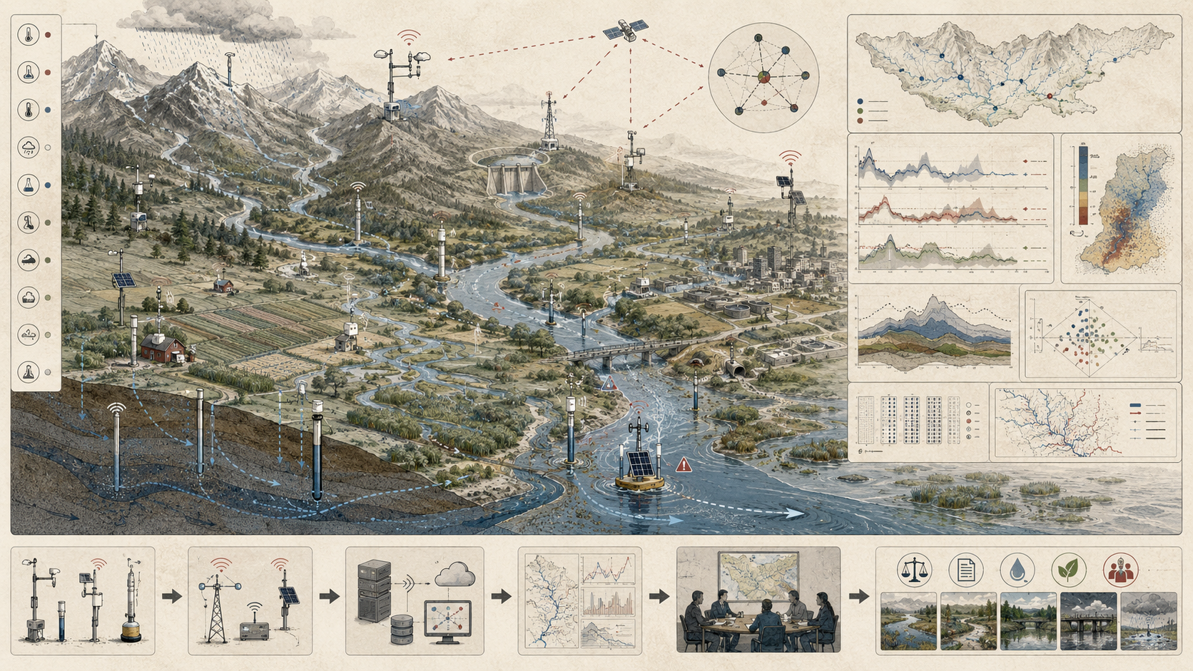
River and watershed monitoring networks are distributed socio-technical infrastructures through which connected drainage systems become measurable, interpretable, and governable across space, time, and scale. They combine streamgages, water-quality stations, ecological assessment sites, precipitation networks, groundwater observations, telemetry, geospatial analysis, remote sensing, hydrological models, and basin-scale interpretive frameworks in order to understand how water, sediment, nutrients, contaminants, heat, habitat condition, and ecological change move through river systems. In this sense, watershed monitoring is not simply the placement of instruments at multiple locations. It is the disciplined construction of basin visibility: a way of making a branching hydrological system legible enough to support flood and drought management, water allocation, ecological stewardship, pollution control, infrastructure planning, and long-horizon watershed governance.
River basins pose a distinctive observational challenge because they are both connected and unequal. Conditions measured at one point rarely belong only to that point. Upstream rainfall, land use, withdrawals, groundwater exchange, channel alteration, reservoir operations, tributary inputs, riparian disturbance, wastewater discharges, agricultural runoff, and ecological change all shape what appears downstream. Yet not every tributary can be instrumented, not every event can be captured, and not every sub-basin is equally monitored. Watershed monitoring is therefore always a problem of selective visibility. A network does not observe the whole basin in any exhaustive sense; it creates a strategically partial picture from which basin-scale inferences become possible.
This is why river monitoring is fundamentally more than site-based measurement. It is a problem of topology, transport, representativeness, temporal continuity, and institutional coordination. The meaning of a station depends on its position in a branching network, on what lies upstream, on how flows and materials travel through the basin, and on what other sites make comparison possible. A basin can appear well observed while still containing major blind spots in ungauged headwaters, event-driven tributaries, groundwater-connected reaches, floodplain exchange zones, or politically fragmented jurisdictions. The deeper value of watershed monitoring lies not in the number of instruments deployed, but in whether the network is structured well enough to turn hydrological connectivity into actionable knowledge.
Main Library
Publications
Article Map
Environmental Monitoring
Related Topic
Data Systems
Related Topic
Risk & Resilience
Related Topic
Intelligent Infrastructure
Watershed monitoring is where distributed environmental observation becomes basin intelligence. It asks not only whether a stream reach, gauge, or water-quality station has data, but whether those data are positioned within a network that can explain upstream contribution, downstream consequence, event timing, cumulative load, ecological response, and governance responsibility. The central question is not simply whether a basin has monitoring sites. It is whether the network can transform connected water movement into defensible watershed knowledge.
Engineering Problem
The engineering problem is how to design river and watershed monitoring networks that can transform distributed, uneven, temporally variable observations into defensible knowledge about basin behavior. A watershed is not a single observation point. It is a connected drainage system composed of headwaters, tributaries, main stems, floodplains, wetlands, aquifers, reservoirs, engineered drainage, land uses, withdrawals, returns, and ecological communities. Monitoring must therefore represent both local condition and network relation.
This problem is difficult because river systems integrate processes across space. A downstream station may reveal cumulative basin response but conceal source attribution. A tributary station may isolate a sub-basin but miss downstream transformation. A water-quality sample may reveal concentration but not transported load without flow. A telemetered gauge may update continuously but remain poorly representative of ungauged headwaters, storm-event pulses, floodplain exchange, or groundwater-connected pathways. A network is only useful if its topology, metadata, sampling design, telemetry, and analytical methods align with the basin questions being asked.
Weak watershed monitoring treats sites as isolated measurement points. Strong watershed monitoring treats sites as nodes in a hydrological graph. It asks which upstream areas each station represents, which pathways remain unobserved, how tributary signals accumulate, where storage delays or transforms transport, how event timing is captured, how concentration becomes load, how ecological condition responds, and how basin-scale evidence supports management across jurisdictional boundaries.
| Engineering Tension | Why It Matters | Required Evidence |
|---|---|---|
| Site measurement versus network inference | A station produces local evidence, but watershed decisions require upstream–downstream reasoning. | Node registry, topology graph, upstream area, confluence relationships |
| Outlet integration versus source attribution | Basin outlets quantify cumulative export but often cannot identify internal source areas. | Paired sites, tributary coverage, sub-basin attribution design |
| Concentration versus load | Water-quality concentration alone does not show mass transport without flow. | Flow records, sample timing, load estimation method, uncertainty statement |
| Continuous telemetry versus representativeness | Real-time data can still miss crucial unmonitored tributaries, event pulses, or ecological responses. | Coverage audit, event-capture assessment, representativeness review |
| Hydrological boundaries versus administrative boundaries | Basins cross jurisdictions even when monitoring programs and budgets do not. | Data-sharing agreements, transboundary protocols, shared metadata standards |
| Long-term continuity versus emerging pressures | Trend stations preserve continuity, but new land-use, climate, and infrastructure pressures may appear elsewhere. | Legacy-station review, pressure-layer analysis, network adaptation log |
| Network density versus sustainability | Dense networks improve visibility but increase cost, maintenance, and data-management burden. | Design rationale, priority tiers, maintenance plan, funding model |
The practical question is therefore: does the monitoring network support the basin-scale inference being made, or does it merely provide a collection of local readings that appear more complete than they are?
Reference Architecture
A practical watershed monitoring architecture can be understood as a basin-scale evidence system. The exact implementation may include streamgages, stage sensors, discharge measurements, water-quality sondes, grab samples, sediment monitoring, nutrient sampling, ecological assessment sites, biological indicators, precipitation networks, snow observations, groundwater wells, reservoir data, telemetry systems, geospatial layers, hydrological models, public dashboards, data portals, and governance workflows. The responsibilities remain consistent: observe, contextualize, transmit, validate, integrate, infer, decide, document, and revise.
| Layer | Engineering Role | Primary Risk | Evidence Artifact |
|---|---|---|---|
| Objective and basin layer | Defines watershed boundary, sub-basins, decision use, target variables, time horizon, and governance purpose. | Monitoring is designed around available stations rather than watershed questions. | Watershed objective manifest, basin boundary, decision-use statement |
| Topology and network layer | Represents headwaters, tributaries, confluences, main stems, outlets, reservoirs, groundwater connections, and monitoring nodes. | Stations are interpreted without hydrological relation. | Network graph, node registry, upstream-area table, confluence matrix |
| Observation layer | Measures stage, discharge, quality, sediment, nutrients, temperature, habitat, ecology, rainfall, snow, groundwater, and management context. | Important basin processes are under-observed or observed at the wrong temporal scale. | Sensor registry, sampling protocol, ecological site registry, driver matrix |
| Telemetry and data layer | Moves data into operational and analytical systems while preserving timestamps, units, station status, and quality flags. | Data arrive without enough metadata, quality, or continuity to support inference. | Telemetry log, data-quality flags, completeness report, archive metadata |
| Validation and QA/QC layer | Checks station health, rating relations, sensor drift, sampling integrity, missingness, and plausibility. | Faulty or biased data become basin-scale conclusions. | QA/QC policy, maintenance log, rating review, sample validation record |
| Integration and analytics layer | Combines flow, quality, ecology, meteorology, land use, groundwater, and basin topology to estimate trends, loads, sources, and risks. | Point observations are aggregated without transport or uncertainty logic. | Load model card, trend analysis, source-attribution workflow, uncertainty statement |
| Decision and governance layer | Connects basin evidence to flood, drought, restoration, pollution, allocation, habitat, infrastructure, and transboundary decisions. | Monitoring becomes technically informative but institutionally disconnected. | Decision log, watershed plan, data-sharing agreement, governance record |
This architecture makes clear that watershed monitoring is not only environmental measurement. It is the management of an evidence chain from distributed basin observations to basin-scale judgment and accountability.
Implementation Pattern
A rigorous watershed monitoring implementation begins with the basin question being supported. Flood forecasting, drought planning, nutrient-load reduction, habitat restoration, reservoir operations, water allocation, temperature management, sediment control, groundwater–surface-water exchange, and ecological condition assessment do not require identical network designs. Each purpose implies different site locations, variables, sampling frequencies, telemetry needs, QA/QC procedures, historical continuity requirements, and analytical methods.
| Artifact | Purpose | Suggested Format |
|---|---|---|
| Watershed objective manifest | Defines basin boundary, monitoring purpose, target variables, decision use, agencies, and time horizon. | YAML, Markdown, architecture decision record |
| Basin topology graph | Represents stream network structure, confluences, upstream areas, outlets, and monitoring-node relationships. | Graph file, GeoJSON, SQL tables, network edge list |
| Monitoring node registry | Stores station ID, location, site type, variables, agency, upstream area, drainage position, and continuity status. | CSV, SQL table, geospatial registry |
| Hydrological driver matrix | Links basin processes such as runoff, groundwater exchange, reservoir operations, land use, and precipitation to observed variables. | CSV, Markdown table, model configuration |
| Water-quality and load records | Stores concentration, discharge, sampling method, load estimates, event flags, and uncertainty. | CSV, Parquet, SQL table, time-series database |
| Ecological assessment registry | Stores habitat, biotic, temperature, geomorphic, and biological response information. | CSV, SQL table, field protocol archive |
| Telemetry and station-health log | Tracks expected data, received data, latency, outages, stale data, sensor status, and maintenance. | CSV, observability export, time-series health table |
| Representativeness audit | Identifies ungauged tributaries, under-sampled headwaters, event gaps, and political or historical station biases. | CSV, GIS layer, audit memo |
| Governance and data-sharing log | Tracks data ownership, standards, revision history, cross-agency exchange, caveats, and public evidence. | CSV, Markdown, SQL table, policy record |
The implementation goal is to make watershed conclusions reconstructable. A user should be able to move from a basin claim — about nutrient loads, low-flow stress, flood response, restoration benefit, sediment transport, source attribution, or ecological condition — back to the monitoring nodes, flow records, samples, topology, telemetry, assumptions, and governance rules that produced it.
Research-Grade Framing: Watershed Monitoring as Basin-Scale Knowledge Infrastructure
A research-grade account of river and watershed monitoring begins by treating monitoring networks as basin-scale knowledge infrastructure rather than as a collection of stations. These networks determine which tributaries become visible, which reaches are continuously observed, which events are captured, how upstream–downstream relationships are interpreted, how basin exports are quantified, and how evidence can be shared across institutions. They shape not merely what is measured, but what kinds of watershed claims become possible.
This role is epistemically demanding because river basins are not self-evident systems. Their boundaries are hydrological rather than administrative. Their most consequential processes are often distributed, delayed, cumulative, and event-sensitive. Responses depend on nested sub-basins, pathway connectivity, residence time, storage effects, groundwater exchange, land-use history, infrastructure, and interactions among climate, hydrology, geomorphology, and ecology. Monitoring networks create the observational scaffolding through which basin function can be interpreted rather than guessed.
This knowledge is always selective. No network sees everything. Site placement reflects funding histories, institutional priorities, accessibility, flood risk, bridge locations, political boundaries, long-term record value, and historical precedent as much as pure scientific logic. Watershed monitoring therefore produces patterned visibility rather than total visibility. Some pathways become legible; others remain weakly observed. This is why network design is not a neutral technical matter. It shapes what kinds of basin problems can be detected, attributed, and governed.
| Limited Pattern | Stronger Pattern | Why the Shift Matters |
|---|---|---|
| Collect measurements at many sites | Design a topology-aware network for basin-scale inference | Prevents station count from being mistaken for network quality. |
| Track river condition locally | Connect local condition to upstream drivers and downstream consequence | Transforms observations into watershed diagnosis. |
| Report concentration values | Estimate loads, fluxes, event contributions, and cumulative exports | Links water quality to transported material and basin impact. |
| Maintain legacy stations | Balance long-term continuity with emerging basin pressures | Protects trend analysis while adapting to new risks. |
| Publish data separately by agency | Use interoperable data sharing and common metadata for basin governance | Reduces institutional fragmentation across hydrologically connected systems. |
| Analyze observed places only | Explicitly audit ungauged, under-sampled, and politically invisible areas | Improves representativeness and hydrological accountability. |
The central research question is not “How many watershed stations exist?” but “What kind of basin knowledge does the network produce, at what scale, with what blind spots, and for what governance purpose?”
Formal Model: Topology, Load, Representativeness, and Basin Evidence Quality
A useful formal model separates monitoring nodes, basin topology, discharge, concentration, load, upstream contribution, residence time, network coverage, temporal continuity, representativeness, interoperability, and governance readiness. Let \(G = (V,E)\) represent the river network graph, where monitoring nodes are a subset \(V_m \subseteq V\), \(Q\) represents discharge, \(C\) concentration, \(L\) load, \(A_u\) upstream contributing area, \(T_c\) temporal continuity, \(R_n\) representativeness, \(I_d\) interoperability, and \(G_r\) governance readiness.
G = (V, E)
\]
Interpretation: A watershed can be represented as a graph of river reaches, tributaries, confluences, and monitoring nodes. Network structure shapes what can be inferred.
L(t) = C(t)Q(t)
\]
Interpretation: Instantaneous load is concentration multiplied by discharge. This distinguishes point condition from transported mass.
L_{\mathrm{event}} = \int_{t_0}^{t_1} C(t)Q(t)\,dt
\]
Interpretation: Event load integrates transported mass over time, which is critical for storm-driven nutrient, sediment, or contaminant pulses.
C_{\mathrm{coverage}} = \frac{A_{\mathrm{monitored}}}{A_{\mathrm{basin}}}
\]
Interpretation: Coverage ratio estimates how much of the basin is represented by monitoring nodes, while recognizing that area alone does not capture all representativeness concerns.
R_{\mathrm{network}} =
w_1C_{\mathrm{coverage}} +
w_2T_c +
w_3D_v +
w_4E_c +
w_5I_d +
w_6G_r
\]
Interpretation: Network readiness depends on coverage, temporal continuity, variable diversity, event capture, data interoperability, and governance readiness.
Q_{\mathrm{watershed\ evidence}} =
w_1C_g +
w_2C_q +
w_3C_e +
w_4R_n +
w_5T_c +
w_6E_c +
w_7U_c +
w_8I_d +
w_9G_r
\]
Interpretation: Watershed evidence quality depends on gauge coverage, water-quality coverage, ecological coverage, representativeness, temporal continuity, event capture, uncertainty communication, interoperability, and governance readiness.
This formal structure protects against a common mistake in watershed monitoring: treating an observed station as if it automatically represented a basin. Basin evidence becomes stronger when site position, topology, flow, transported load, temporal continuity, event capture, and governance are evaluated together.
What Are River and Watershed Monitoring Networks?
River and watershed monitoring networks are coordinated systems of observation distributed across a drainage basin in order to measure hydrological behavior, water quality, ecological condition, geomorphic change, and related environmental processes. They typically consist of multiple monitoring nodes positioned across headwaters, tributaries, main stems, floodplains, reservoirs, groundwater-connected zones, estuarine transitions, or managed infrastructure reaches, with each node contributing a partial but strategically important perspective on basin behavior.
These networks may include streamgages measuring stage, discharge, and flow variability; water-quality stations and real-time sensor platforms; ecological monitoring sites assessing habitat and aquatic biota; precipitation, meteorological, snowpack, and groundwater observations; telemetry, archives, dashboards, and geospatial analysis platforms; and network design frameworks determining site placement, density, continuity, and purpose. USGS water monitoring resources emphasize national observing networks, real-time water conditions, and future water-availability prediction. Federal Priority Streamgages are automated stations that monitor water conditions in streams and rivers, and the network has been re-prioritized to nearly 12,400 locations. WMO’s Hydrological Observing System supports hydrological data exchange and access across national, regional, and international levels. EPA’s watershed approach frames water-quality management around drainage areas and watershed-scale coordination.
The defining feature of a watershed monitoring network is relationality. A site is not meaningful in isolation. Its interpretive value depends on where it sits in the basin, what other sites surround it, which tributaries feed it, what storage or regulation lies upstream, and what management question the network is meant to answer. A downstream gauge may integrate large-scale basin behavior. A tributary site may isolate sub-basin contributions. A paired site above and below a confluence, reservoir, city, restoration reach, or discharge can reveal change across a specific influence. Watershed monitoring is therefore not merely multi-site measurement. It is networked inference over connected hydrological space.
| Monitoring Form | Primary Question | Typical Evidence | Main Risk |
|---|---|---|---|
| Streamflow monitoring | How much water is moving through the river network? | Stage, discharge, rating curves, hydrographs, flow duration | Flow is interpreted without basin topology, regulation, or tributary context. |
| Water-quality monitoring | What is the condition of water and what constituents are moving? | Nutrients, sediment, temperature, dissolved oxygen, conductivity, contaminants | Concentration is interpreted without flow, load, or event timing. |
| Ecological monitoring | How are aquatic habitats and organisms responding to basin pressures? | Macroinvertebrates, fish, habitat scores, riparian condition, thermal regime | Biological response is disconnected from hydrological and chemical drivers. |
| Meteorological and precipitation monitoring | What forcing conditions drive runoff, drought, flood, and transport? | Rainfall, snowpack, temperature, evapotranspiration, storm intensity | Channel response is interpreted without climate or storm context. |
| Groundwater and storage monitoring | How do aquifers, wetlands, reservoirs, and floodplains influence basin response? | Groundwater levels, reservoir storage, wetland stage, baseflow indicators | Surface-water monitoring misses delayed exchange and storage effects. |
| Network governance monitoring | Can data be shared, maintained, interpreted, and used across jurisdictions? | Data standards, agency agreements, metadata, public evidence records | Hydrological continuity is undermined by institutional fragmentation. |
River and watershed monitoring networks are therefore not just collections of water stations. They are structured systems for making basin connectivity empirically visible.
Why Watershed Monitoring Networks Matter
Watershed monitoring networks matter because river basins are systems of movement. Water does not remain where it falls. Sediment, nutrients, dissolved constituents, contaminants, heat, organisms, and hydrological impulses travel through tributaries, channels, aquifers, wetlands, reservoirs, floodplains, and estuaries. A flood pulse in one part of a basin can propagate downstream. A nutrient source in a sub-basin can become a downstream eutrophication problem. Land-use change in headwaters can alter sediment, temperature, and ecological condition far from its point of origin. Monitoring networks make these connected consequences observable.
They also matter because local observations without network context are often misleading. A single downstream site may detect altered flow, degraded quality, or ecological stress, yet reveal little about where the relevant upstream driver is located, whether multiple tributaries are involved, whether the signal is event-driven or chronic, or whether basin storage and retention are muting or amplifying transport. Conversely, a site that appears locally healthy may still sit within a basin whose cumulative export is ecologically damaging elsewhere. Basin-scale understanding requires comparison, topology, and transport logic that isolated sites cannot provide.
Watershed monitoring networks matter institutionally because many important water decisions are inherently basin decisions. Flood forecasting, drought planning, reservoir operations, water allocation, restoration targeting, habitat protection, pollution control, infrastructure design, source-water protection, and transboundary water coordination all depend on understanding conditions across connected catchments rather than within single administrative fragments. Where networks are strong, basins become more diagnosable and governable. Where they are weak, water governance is forced to operate through partial visibility and fragmented evidence.
| Need | Network Contribution | Risk Without Networked Monitoring |
|---|---|---|
| Flood forecasting | Tracks upstream rainfall, stage, discharge, rate of rise, storage, and downstream response. | Warnings rely on incomplete basin-state information. |
| Drought and low-flow management | Connects flow records, groundwater, storage, withdrawals, and ecological stress. | Water scarcity is interpreted through isolated sites rather than basin condition. |
| Pollution control | Identifies source areas, tributary contributions, loads, and downstream impacts. | Management focuses on visible sites while diffuse sources remain hidden. |
| Restoration targeting | Reveals where habitat, flow, water quality, and ecological response intersect. | Projects are selected without basin-scale diagnostic evidence. |
| Water allocation | Links available flow, withdrawals, return flows, seasonal patterns, and downstream obligations. | Allocation decisions rely on incomplete spatial and temporal evidence. |
| Ecological stewardship | Connects hydrological alteration, thermal regime, sediment, habitat, and biological response. | Ecological decline is treated as local rather than cumulative. |
| Transboundary governance | Creates shared evidence across jurisdictions, agencies, and political boundaries. | Fragmented data allow upstream–downstream accountability gaps. |
Watershed networks matter because rivers connect consequences across distance. Without networked observation, those consequences can remain politically and analytically fragmented even when they are hydrologically continuous.
Watershed Monitoring as Basin-Scale Knowledge Infrastructure
A true synthesis of river and watershed monitoring requires treating these networks as basin-scale knowledge infrastructures. They organize how a river system becomes knowable. They determine which tributaries are visible, which reaches are continuously observed, what forms of change can be detected, what temporal scales are preserved, and what sorts of claims can be made about basin condition with confidence.
This epistemic role matters because river basins are not self-evident systems. Their boundaries are hydrological rather than administrative. Their most consequential processes are often distributed and delayed. Their responses depend on nested sub-basins, pathway connectivity, event timing, storage effects, and interactions among climate, land use, infrastructure, groundwater, and ecology. Monitoring networks are what convert this complexity into a working map of evidence. They create the observational scaffolding through which basin function can be interpreted rather than guessed.
Yet this knowledge is always selective. No network sees everything. Site placement reflects funding histories, institutional priorities, accessibility, flood risk, political boundaries, existing infrastructure, and historical precedent as much as pure scientific logic. Watershed monitoring therefore produces patterned visibility rather than total visibility. Some pathways become legible; others remain weakly observed. This is why network design is not a neutral technical matter. It shapes what kinds of basin problems can be detected, attributed, and governed.
| Monitoring Choice | What Becomes More Visible | What May Remain Less Visible |
|---|---|---|
| Outlet-focused monitoring | Total basin export, integrated flow, downstream condition. | Internal source attribution, tributary differences, headwater change. |
| Dense tributary monitoring | Sub-basin contributions and comparative source areas. | Long-term outlet integration if continuity is weak. |
| Real-time gaging | Hydrological dynamics, floods, low flows, operational status. | Constituent transport, ecology, habitat, and unmonitored pathways. |
| Water-quality sampling | Chemical condition, pollution signals, constituent patterns. | Load and transport unless paired with flow and event timing. |
| Ecological assessment | Biological response, habitat condition, cumulative stress. | Hydrological and chemical mechanism unless paired with driver data. |
| Shared data portals | Cross-agency access and interoperability. | Local context, data lineage, and interpretation caveats if metadata are weak. |
Watershed monitoring is powerful because it turns a hidden topology of water movement into public evidence. It is risky when the network’s partial visibility is mistaken for complete basin knowledge.
Network Topology, Tributaries, and Selective Visibility
The logic of watershed monitoring begins with drainage topology. River systems are branching networks in which headwaters join tributaries, tributaries join larger main stems, and the combined basin eventually discharges into lakes, reservoirs, estuaries, or the sea. This branching structure means that monitoring design must account for confluences, stream order, drainage area, tributary hierarchy, pathway connectivity, and cumulative integration.
Topology matters because basin position changes interpretive meaning. Headwater stations may be useful for identifying source areas, reference conditions, or early ecological and hydrological disturbance. Mid-basin tributary stations can isolate land-use transitions, urban inputs, irrigation return flows, reservoir effects, wastewater discharges, or geomorphic changes. Main-stem stations reveal integrated basin response but often at the cost of diagnostic specificity. Outlet stations quantify export from the basin as a whole, yet cannot by themselves explain how internal basin processes produced the observed signal.
This is where selective visibility becomes central. A network that heavily instruments outlets but neglects headwaters may be strong on integration but weak on attribution. A network that monitors accessible tributaries while leaving remote sub-basins ungauged may over-represent certain forms of risk and under-represent others. A basin with many legacy stations may still lack coverage where contemporary pressures are emerging. Network topology therefore shapes not only what is measured, but what kinds of inference are possible.
| Network Position | Primary Value | Common Use | Key Limitation |
|---|---|---|---|
| Headwater station | Early source-area detection and reference-condition comparison. | Detect land-use change, thermal stress, ecological disturbance, sediment pulses. | May represent only a small area or specific headwater condition. |
| Tributary station | Sub-basin attribution and comparison. | Identify nutrient, sediment, flow, or temperature contributions by sub-basin. | May miss within-tributary heterogeneity and event pulses. |
| Confluence pair | Change detection across tributary joins, cities, reservoirs, or discharges. | Assess incremental contribution or effect of a specific basin feature. | Requires careful timing and flow-adjusted interpretation. |
| Main-stem station | Integrated river condition and downstream transport. | Flood tracking, low-flow stress, cumulative quality, basin-scale trend. | Weak source attribution without upstream network support. |
| Outlet station | Total basin export and downstream boundary condition. | Quantify basin loads, water balance, integrated response, interstate or estuarine delivery. | Cannot explain internal assembly of the signal alone. |
| Groundwater-connected reach | Baseflow, thermal buffering, delayed flow, and chemical exchange. | Interpret drought resilience, nutrient persistence, cold-water habitat, groundwater contamination. | Often under-observed compared with surface-channel sites. |
A watershed network becomes analytically strong when its topology supports the inference it is asked to make. Station density matters, but station relation matters more.
Key Analytical Distinctions
A monitoring site is not the same as a monitoring network. A site generates local evidence. A network allows basin-scale reasoning through spatial relation, comparison, cumulative integration, and topological interpretation.
Streamflow monitoring is not the same as watershed monitoring. Streamgages are foundational, but basin intelligence often also requires water-quality stations, ecological sites, precipitation and snow observations, groundwater information, land-use context, and governance metadata.
An outlet station is not the same as source diagnosis. Monitoring at the basin outlet can reveal aggregate export or integrated change, but it cannot by itself determine which tributary, sub-basin, pathway, or timing dynamic is responsible.
Concentration is not the same as load. Concentration describes condition at a point in time and space; load describes the mass transported through the network over time. In many basin decisions, the latter is more consequential.
Real-time visibility is not the same as representativeness. A telemetered station can update rapidly while still missing crucial tributaries, groundwater interactions, event pulses, or ecological responses elsewhere in the basin.
Administrative jurisdiction is not the same as watershed structure. River basins frequently cross legal, political, and institutional boundaries. Monitoring designed only within one administrative frame may underperform as basin observation.
| Distinction | Why It Matters | Design Implication |
|---|---|---|
| Site versus network | Local data do not automatically support basin inference. | Represent stations as connected nodes with upstream and downstream metadata. |
| Flow versus watershed condition | Discharge is foundational but does not capture chemistry, ecology, habitat, or governance. | Combine hydrometry with quality, ecology, meteorology, groundwater, and land-use context. |
| Outlet export versus source attribution | Total export does not identify internal source areas. | Use tributary stations, paired sites, and sub-basin load analysis. |
| Concentration versus load | Concentration without flow can misstate transported significance. | Pair water-quality sampling with discharge and event timing. |
| Real-time data versus representative data | Rapid updates can still be spatially biased. | Audit coverage, site placement, and under-sampled basin processes. |
| Administrative boundary versus basin boundary | Water crosses jurisdictions even when monitoring systems do not. | Use shared data standards, cross-boundary agreements, and basin-scale governance. |
These distinctions prevent watershed monitoring from being reduced to a map of stations. The system’s value lies in the relationship between observation, topology, transport, interpretation, and governance.
System Architecture: From Monitoring Nodes to Basin Intelligence
River and watershed monitoring networks operate as layered architectures that transform local observations into system-level understanding. Streamgages, quality stations, ecological sites, precipitation gauges, groundwater wells, reservoir records, and remote-sensing products collect partial evidence. Data are time-stamped, georeferenced, quality-checked, and linked to basin metadata such as drainage area, site type, stream order, regulation status, upstream land use, and connectivity. Network integration then interprets observations in relation to tributary hierarchy, confluences, storage elements, groundwater exchange, floodplains, and basin boundaries. Analytical workflows estimate trends, loads, thresholds, ecological responses, anomalies, basin exports, and source contributions. Agencies and stakeholders use the resulting basin intelligence for forecasting, planning, restoration, allocation, pollution control, and governance.
| Stage | Transformation | Failure Risk |
|---|---|---|
| Basin process | Water, sediment, nutrients, heat, organisms, and contaminants move through connected pathways. | The selected monitoring variables do not represent the process of concern. |
| Node observation | Stations and sampling sites capture local evidence. | Sites are poorly placed, sparse, or biased toward accessible locations. |
| Metadata and topology | Observations are linked to drainage area, upstream land use, confluences, site type, and network position. | Data are interpreted without hydrological relation. |
| Telemetry and archiving | Data move into operational, analytical, and public systems. | Missingness, stale data, or weak metadata reduce trust and reuse. |
| Validation and QA/QC | Records are checked for plausibility, drift, rating status, sample integrity, and event completeness. | Bad data become basin-scale conclusions. |
| Network integration | Local records are interpreted across upstream–downstream structure and sub-basin comparison. | Stations remain isolated rather than becoming network evidence. |
| Analysis and inference | Trends, loads, source areas, ecological responses, and basin exports are estimated. | Inference exceeds what the network can support. |
| Decision and governance | Evidence supports flood, drought, restoration, pollution, allocation, and transboundary decisions. | Monitoring remains informational but not accountable to basin governance. |
This layered structure highlights a central truth: basin intelligence does not emerge automatically from having many sites. It emerges when sites are connected through hydrological reasoning. A network becomes powerful when its topology, metadata, and interpretive framework are strong enough to transform distributed observations into coherent understanding of basin function.
Core Network Elements: Flow, Quality, Ecology, and Context
Streamgages provide the hydrological backbone. They measure stage, discharge, and temporal flow behavior, enabling interpretation of flood peaks, low-flow stress, water availability, transport potential, and long-term hydrologic change. Their value depends on station placement, rating relations, continuity, telemetry, maintenance, and the degree to which the monitored point represents the reach or sub-basin being interpreted.
Water-quality stations extend networks from water movement to water condition. When colocated with flow stations, they allow concentration data to be interpreted alongside hydrological regime and, where possible, converted into loads or export estimates. This is crucial because constituent significance often depends on transport, not only point value. Nutrients, sediment, temperature, dissolved oxygen, conductivity, and contaminants are all more meaningful when interpreted through flow, season, event timing, and upstream source context.
Ecological assessment sites contribute evidence about biological condition, habitat integrity, and aquatic response to cumulative pressures. They help reveal basin impairment that may not be evident from chemistry or hydrometry alone. Biological monitoring can register chronic stress, altered thermal regime, habitat fragmentation, sedimentation, flow alteration, and cumulative land-use effects.
Precipitation, snow, meteorological, and groundwater observations provide crucial context for basin response. Storm intensity, snowmelt timing, evapotranspiration conditions, groundwater connectivity, reservoir operations, and antecedent moisture all shape river behavior in ways that channel-only monitoring cannot fully capture. The strongest watershed networks are multi-dimensional because basin condition is multi-dimensional.
| Element | Primary Role | Evidence Needed | Failure Mode |
|---|---|---|---|
| Streamgage | Measures stage, discharge, hydrograph dynamics, and flow regime. | Station metadata, rating curve, drainage area, telemetry status, maintenance log. | Flow data are interpreted without rating uncertainty or basin context. |
| Water-quality station | Measures chemical, physical, and thermal water condition. | Sampling method, parameter list, detection limits, QA/QC flags, flow linkage. | Concentration is reported without load or event interpretation. |
| Ecological site | Assesses habitat, biological response, and cumulative ecological condition. | Protocol, taxa, habitat score, reach context, season, disturbance history. | Biological condition is disconnected from hydrological drivers. |
| Meteorological and precipitation station | Measures hydrological forcing and basin climate context. | Rainfall intensity, accumulation, snow, temperature, evapotranspiration. | River response is analyzed without storm or climate forcing. |
| Groundwater observation | Tracks baseflow, aquifer exchange, drought storage, and delayed pathways. | Well level, aquifer context, stream connection, sampling continuity. | Surface flow is treated as isolated from subsurface storage. |
| Reservoir and infrastructure record | Documents managed storage, releases, withdrawals, returns, and regulation. | Storage, release schedule, gate status, withdrawal and return records. | Regulated flow is interpreted as natural basin behavior. |
| Geospatial basin layer | Links stations to land use, drainage area, soils, geology, slopes, and communities. | GIS layers, basin boundaries, sub-basin maps, land-cover history. | Monitoring lacks spatial explanatory context. |
Flow regime, constituent transport, habitat condition, geomorphic adjustment, and ecological response are not separate domains in the river itself. They are analytically separate because observation must simplify a coupled system. A strong watershed network reconnects them.
Fluxes, Loads, Residence Time, and Upstream–Downstream Inference
River and watershed networks become especially powerful when they move beyond static point condition to questions of movement. Concentration at a site indicates local status at a moment. Load indicates how much material is being transported through the network over time. Export describes what leaves a sub-basin or the basin as a whole. These are different analytical objects, and many watershed decisions depend more on the latter two than on the first alone.
This matters because rivers are transport systems. A moderate concentration under high discharge can produce a substantial load. A high concentration under low discharge may signal local stress but limited basin export. Residence time, storage, channel retention, wetland buffering, floodplain exchange, reservoir trapping, groundwater exchange, and biogeochemical transformation can all alter what moves, what is delayed, and what is retained. Basin monitoring therefore needs to ask not only “what is the value here?” but “what is moving, when, at what magnitude, through which pathway, and with what downstream consequence?”
Upstream–downstream inference depends on this transport logic. Paired sites can reveal changes across tributary confluences, urban corridors, reservoir transitions, abstraction zones, wastewater discharges, irrigation return flows, or restoration reaches. Tributary monitoring can identify which sub-basins contribute the greatest nutrient, sediment, thermal, or contaminant burden. Outlet monitoring can quantify total basin export, while internal stations explain how that export is assembled. Monitoring becomes most intellectually powerful when it can connect point condition, pathway movement, and cumulative basin consequence in one interpretive frame.
| Concept | Meaning | Network Requirement | Interpretive Risk |
|---|---|---|---|
| Concentration | Amount of a constituent per unit volume at a site and time. | Water-quality sampling, sensor calibration, QA/QC metadata. | High or low values are overinterpreted without flow context. |
| Discharge | Volume of water moving through a channel per unit time. | Streamgage, rating curve, stage-discharge relation, uncertainty. | Rating shifts or regulation are ignored. |
| Instantaneous load | Mass transported at a point in time. | Concentration and discharge paired in time. | Misalignment between sample timing and flow produces bias. |
| Event load | Total transported mass during a storm, flood, pulse, or management event. | High-frequency sampling or defensible interpolation across the event. | Routine sampling misses short-duration peaks. |
| Basin export | Material or water leaving a sub-basin or basin outlet over time. | Outlet monitoring, flow-weighted estimates, uncertainty communication. | Export is quantified without internal source attribution. |
| Residence time | Time water or material spends in channels, reservoirs, wetlands, or aquifers. | Storage context, tracer or model information, flow regime. | Transport is assumed instantaneous when retention or transformation is important. |
Flux thinking shifts watershed monitoring from static condition reporting toward dynamic basin accountability. It shows not only what water is like at a site, but what the river system is carrying, storing, transforming, and exporting.
Blind Spots, Representativeness, and Network Design Tradeoffs
One of the central challenges in watershed monitoring is that no network can observe every tributary, spring, floodplain, discharge, headwater, ditch, groundwater pathway, wetland, reservoir inlet, storm drain, or ecological response. Networks therefore balance density, continuity, cost, accessibility, maintenance burden, historical value, and decision purpose. Every such balance creates blind spots.
Ungauged tributaries are one persistent issue. Small headwaters and intermittent channels can contribute sediment, nutrients, flash response, thermal stress, or ecological signals out of proportion to their size, yet remain weakly monitored. Event undercapture is another major problem. Storm-driven loads, floodplain exchange, contaminant pulses, and geomorphic shifts may occur during short windows that routine schedules miss. Historical bias in site placement can also distort representativeness, since many networks reflect legacy funding, accessible bridges, administrative convenience, or long-established stations rather than contemporary basin pressures.
Nonstationarity further complicates design. Land use changes, climatic shifts, altered snow regimes, urban expansion, wildfire, channel adjustment, groundwater depletion, reservoir operations, and infrastructure modifications can all change basin behavior over time. A network once considered adequate may become less representative under new conditions. Transboundary basins add another challenge: data density, standards, and continuity may change abruptly across institutional borders even when the river system itself is continuous.
| Blind Spot or Tradeoff | How It Appears | Why It Matters | Mitigation |
|---|---|---|---|
| Ungauged headwaters | Small tributaries lack flow, quality, or ecological monitoring. | Source areas and rapid-response pathways remain invisible. | Rotating surveys, low-cost sensors, priority sub-basin screening. |
| Event undercapture | Routine sampling misses storms, pulses, floods, or first-flush events. | Loads and ecological stress can be severely underestimated. | Event-triggered sampling, autosamplers, high-frequency sensors. |
| Legacy station bias | Networks reflect historical convenience rather than current pressure. | Emerging land-use or climate risks remain under-observed. | Periodic network design review and pressure-layer overlays. |
| Groundwater disconnection | Surface-water sites lack aquifer and baseflow context. | Drought, temperature, nutrient, and contaminant persistence may be misread. | Groundwater wells, baseflow separation, paired groundwater–surface-water sites. |
| Ecological lag | Biological response changes more slowly or differently than chemistry or flow. | Restoration or degradation may be overclaimed from short-term signals. | Long-term ecological monitoring and habitat-context integration. |
| Transboundary discontinuity | Data standards, station density, or access change across jurisdictions. | Hydrological continuity is broken by institutional fragmentation. | Interoperable data standards, shared portals, basin agreements. |
| Cost and maintenance burden | Dense networks become difficult to sustain. | Data continuity and quality degrade over time. | Priority tiers, maintenance planning, public evidence justification. |
Representativeness is never a settled property of a network. It is an ongoing design and governance question. A network is strong not because it observes everything, but because it is explicit about what it can see, what it cannot see, and what kinds of inference its topology supports or limits.
Governance, Data Sharing, and Hydrological Accountability
River and watershed monitoring networks are governance infrastructures as much as technical ones. They often cross jurisdictions, depend on multiple agencies and funding streams, and require shared standards and data exchange to support basin-scale decisions. This institutional dimension matters because river systems are hydrologically continuous while governance is often fragmented.
Fragmented monitoring produces fragmented governance. If one jurisdiction measures flood risk, another measures water quality, a third tracks ecological condition, and a fourth lacks durable observation altogether, then basin-scale management becomes uneven not because the river is discontinuous, but because evidence is discontinuous. Upstream impacts may remain politically invisible downstream when the network does not capture their pathways clearly enough. Likewise, restoration or regulation may focus on monitored locations while neglecting poorly observed tributaries that drive cumulative basin outcomes.
This is why watershed monitoring should be understood as an infrastructure of hydrological accountability. Strong networks create shared evidence across administrative boundaries. They make it harder for basin degradation to remain localized in rhetoric while distributed in reality. Weak networks, by contrast, often protect fragmentation rather than the watershed. WMO’s WHOS initiative is especially relevant to this challenge because it supports hydrological data exchange, access, and interoperability across national, regional, and international levels.
| Governance Responsibility | Question | Evidence |
|---|---|---|
| Network design governance | Who decides which tributaries, reaches, variables, and communities are monitored? | Network design rationale, coverage audit, public priority statement |
| Data-quality governance | How are missingness, rating uncertainty, sensor drift, sample quality, and outliers handled? | QA/QC policy, station maintenance log, validation record |
| Interoperability governance | Can agencies and users discover, access, combine, and interpret hydrological data? | Metadata standard, API documentation, data-sharing agreement |
| Threshold and target governance | Who defines water-quality targets, ecological benchmarks, flood stages, and flow objectives? | Threshold registry, stakeholder process, revision history |
| Source-attribution governance | How are upstream contributions, diffuse sources, and cumulative impacts attributed fairly? | Load model card, sub-basin analysis, uncertainty statement |
| Transboundary governance | How are basin-scale data shared across legal and political boundaries? | Cross-jurisdiction agreement, shared portal, harmonized methods |
| Public accountability | Can watershed claims be inspected, contested, and revised? | Public evidence package, governance log, caveat statement |
Governance is how watershed monitoring remains meaningful after data leave the field. Without governance, networks may generate measurements without building shared basin responsibility.
Future Directions
The future of river and watershed monitoring networks lies in deeper integration across hydrometry, water quality, ecological assessment, meteorological inputs, groundwater context, infrastructure operations, and remote sensing, supported by stronger telemetry, interoperable data systems, and basin-scale analytical platforms. The strategic opportunity is not only to add more sites, but to build smarter networks: networks that are topologically informed, event-sensitive, diagnostically useful, and institutionally durable.
Artificial intelligence, sensor networks, satellite products, high-frequency water-quality monitoring, digital twins, graph analytics, and integrated watershed models will likely expand the ability to detect patterns across large basins. But these tools will also make network governance more important. If models infer source contributions, load trends, ecological risk, or restoration effects from partial data, the system must preserve station metadata, topology, calibration, event coverage, uncertainty, model version, and valid-use limits. Otherwise advanced analytics may amplify old blind spots under new technical language.
The deeper challenge is representational and political as much as technical. Future systems will need to better capture ungauged tributaries, nonstationary basin behavior, compound extremes, groundwater–surface-water interactions, event-driven transport, ecological lag, and transboundary discontinuities while preserving long-term continuity for trend analysis. They will also need to integrate flow, constituent transport, ecological condition, geomorphic change, and human infrastructure into more coherent basin intelligence.
River basins are not automatically visible as systems. Without monitoring networks, upstream–downstream relationships remain partly hidden, loads and pathway effects remain ambiguous, and basin governance remains vulnerable to fragmentation and selective attention. Where networks are strong, the watershed becomes more observable, more diagnosable, and more governable. Where networks are weak, uncertainty often shelters diffuse impact and institutional evasion. In that sense, river and watershed monitoring networks are not merely technical supports for water management. They are infrastructures of basin accountability.
Deployment Readiness Gate
Before a river or watershed monitoring network is used for flood forecasting, drought planning, nutrient-load reduction, ecological assessment, restoration targeting, water allocation, transboundary negotiation, source-water protection, or public environmental claims, it should pass a deployment readiness gate. This gate should test whether the network is topologically coherent, representative, temporally adequate, interoperable, uncertainty-aware, and governance-aligned.
| Readiness Area | Required Question | Pass Evidence |
|---|---|---|
| Purpose readiness | Does the network define basin boundary, decision use, target variables, agencies, and time horizon? | Watershed objective manifest, decision-use statement, basin boundary file |
| Topology readiness | Are monitoring sites linked to tributaries, confluences, upstream areas, outlets, and managed infrastructure? | Basin topology graph, node registry, upstream-area table |
| Coverage readiness | Are headwaters, tributaries, main stems, outlets, groundwater connections, and high-pressure areas represented? | Coverage audit, blind-spot map, priority station list |
| Variable readiness | Are flow, quality, ecological, meteorological, groundwater, and land-use variables sufficient for the intended claim? | Variable matrix, monitoring protocol, driver linkage |
| Temporal readiness | Are sampling and telemetry frequencies adequate for trends, low-flow stress, storms, floods, or event loads? | Sampling plan, telemetry report, event-capture assessment |
| Validation readiness | Are rating curves, sensor drift, sample QA/QC, missingness, and station health managed? | QA/QC policy, station maintenance log, validation report |
| Inference readiness | Can the network support claims about loads, sources, trends, restoration effects, or basin exports? | Model card, uncertainty statement, source-attribution method |
| Interoperability readiness | Can data be discovered, shared, combined, and reused across agencies and jurisdictions? | Metadata standard, data portal, API or exchange agreement |
| Governance readiness | Are public accountability, caveats, cross-boundary coordination, funding, and revision responsibilities defined? | Governance log, public evidence package, data-sharing agreement |
This readiness gate prevents watershed monitoring from being treated as complete merely because stations exist. The stronger standard is whether the network can support defensible basin-scale inference and shared hydrological accountability.
Data and Configuration Artifacts
A reproducible watershed-monitoring workflow should include explicit artifacts for basin objectives, topology, monitoring nodes, hydrological drivers, telemetry, water quality, ecological assessment, load estimation, representativeness, data sharing, and governance. These artifacts make basin conclusions auditable rather than hidden inside dashboards, station lists, or isolated agency reports.
| Artifact | Purpose | Suggested Path |
|---|---|---|
| Watershed objective manifest | Defines basin boundary, purpose, decision use, variables, agencies, and time horizon. | config/watershed_objective.yml |
| Basin topology graph | Represents headwaters, tributaries, confluences, main stems, outlets, and monitoring nodes. | data/basin_topology_edges.csv |
| Monitoring node registry | Stores station ID, location, site type, variables, agency, upstream area, and continuity status. | data/monitoring_node_registry.csv |
| Hydrological driver matrix | Links precipitation, land use, groundwater, reservoir operations, and basin features to monitored variables. | data/hydrological_driver_matrix.csv |
| Telemetry and station-health records | Tracks expected data, received data, latency, stale records, outages, and maintenance. | data/telemetry_station_health.csv |
| Water-quality and load records | Stores concentration, discharge, load, event flags, sample method, and uncertainty. | data/water_quality_load_records.csv |
| Ecological assessment registry | Stores habitat, biological, thermal, geomorphic, and ecological response data. | data/ecological_assessment_registry.csv |
| Representativeness audit | Identifies ungauged tributaries, event undercapture, legacy station bias, and transboundary gaps. | data/representativeness_audit.csv |
| Watershed readiness scores | Assesses gauge coverage, quality coverage, ecological coverage, event capture, continuity, interoperability, and governance. | data/watershed_monitoring_readiness_scores.csv |
| Governance and data-sharing log | Tracks cross-agency agreements, caveats, revisions, standards, and public evidence decisions. | data/watershed_governance_log.csv |
These artifacts turn watershed monitoring into a reproducible basin evidence system rather than a loose collection of gauges, samples, maps, and agency datasets.
Mathematical Lens: Watershed Topology, Loads, Coverage, and Basin Evidence Quality
Several simple metrics can help evaluate watershed-monitoring readiness. These metrics are not substitutes for hydrological expertise, field validation, ecological interpretation, or local governance knowledge, but they make basin evidence quality more inspectable.
G = (V, E)
\]
Interpretation: A watershed can be represented as a graph of nodes and edges, where nodes may be confluences, monitoring stations, tributaries, reservoirs, or outlets, and edges represent hydrological connectivity.
L(t) = C(t)Q(t)
\]
Interpretation: Instantaneous load is concentration multiplied by discharge. This distinguishes water-quality condition from material transport.
L_{\mathrm{event}} = \int_{t_0}^{t_1} C(t)Q(t)\,dt
\]
Interpretation: Event load estimates the total mass transported during a storm, pulse, flood, or management-relevant period.
C_{\mathrm{coverage}} = \frac{A_{\mathrm{monitored}}}{A_{\mathrm{basin}}}
\]
Interpretation: Coverage ratio estimates the fraction of basin area represented by monitored sub-basins, while still requiring ecological, topological, and event-capture interpretation.
Q_{\mathrm{watershed\ evidence}} =
w_1C_g +
w_2C_q +
w_3C_e +
w_4R_n +
w_5T_c +
w_6E_c +
w_7U_c +
w_8I_d +
w_9G_r
\]
Interpretation: Watershed evidence quality depends on gauge coverage, water-quality coverage, ecological coverage, network representativeness, temporal continuity, event capture, uncertainty communication, interoperability, and governance readiness.
These measures evaluate watershed monitoring as a basin-scale evidence system. They ask whether the network can support the specific inference being made about water movement, material transport, ecological condition, or hydrological accountability.
Python Workflow: Watershed Monitoring Readiness and Basin Evidence Quality
A Python workflow can demonstrate how watershed networks might be evaluated for gauge coverage, water-quality coverage, ecological coverage, network representativeness, temporal continuity, event capture, uncertainty communication, data interoperability, and governance readiness. The purpose is not to create a universal score, but to make evidence-quality dimensions visible.
from dataclasses import dataclass
from typing import List
import pandas as pd

@dataclass
class WatershedMonitoringNetwork:
    network_id: str
    basin_context: str
    geography: str
    gauge_coverage: float
    water_quality_coverage: float
    ecological_coverage: float
    network_representativeness: float
    temporal_continuity: float
    event_capture: float
    uncertainty_communication: float
    interoperability: float
    governance_readiness: float
    high_stakes_use: bool

def watershed_evidence_quality(network: WatershedMonitoringNetwork) -> float:
    return (
        0.12 * network.gauge_coverage +
        0.12 * network.water_quality_coverage +
        0.10 * network.ecological_coverage +
        0.13 * network.network_representativeness +
        0.12 * network.temporal_continuity +
        0.12 * network.event_capture +
        0.09 * network.uncertainty_communication +
        0.10 * network.interoperability +
        0.10 * network.governance_readiness
    )

def classify_review_priority(network: WatershedMonitoringNetwork, score: float) -> str:
    if network.high_stakes_use and network.network_representativeness < 0.70:
        return "high_stakes_representativeness_review"
    if network.gauge_coverage < 0.70:
        return "gauge_coverage_review"
    if network.water_quality_coverage < 0.70:
        return "water_quality_coverage_review"
    if network.ecological_coverage < 0.65:
        return "ecological_coverage_review"
    if network.temporal_continuity < 0.70:
        return "temporal_continuity_review"
    if network.event_capture < 0.70:
        return "event_capture_review"
    if network.interoperability < 0.75:
        return "interoperability_review"
    if network.governance_readiness < 0.75:
        return "governance_readiness_review"
    if score < 0.75:
        return "watershed_evidence_quality_review"
    return "routine_monitoring"

networks: List[WatershedMonitoringNetwork] = [
    WatershedMonitoringNetwork(
        "mainstem-integrated-basin-network",
        "large_river_basin",
        "regional_watershed",
        0.84,
        0.78,
        0.72,
        0.80,
        0.86,
        0.76,
        0.78,
        0.82,
        0.84,
        True,
    ),
    WatershedMonitoringNetwork(
        "headwater-source-area-network",
        "headwater_tributaries",
        "upper_basin",
        0.68,
        0.72,
        0.70,
        0.66,
        0.74,
        0.64,
        0.72,
        0.70,
        0.72,
        True,
    ),
    WatershedMonitoringNetwork(
        "urban-tributary-load-network",
        "urbanizing_subbasins",
        "metro_watershed",
        0.72,
        0.80,
        0.62,
        0.70,
        0.78,
        0.82,
        0.76,
        0.74,
        0.76,
        True,
    ),
    WatershedMonitoringNetwork(
        "transboundary-data-sharing-network",
        "cross_jurisdictional_basin",
        "multi_agency_watershed",
        0.76,
        0.70,
        0.66,
        0.72,
        0.80,
        0.68,
        0.74,
        0.62,
        0.68,
        True,
    ),
]

records = []
for network in networks:
    score = watershed_evidence_quality(network)
    records.append({
        "network_id": network.network_id,
        "basin_context": network.basin_context,
        "geography": network.geography,
        "gauge_coverage": network.gauge_coverage,
        "water_quality_coverage": network.water_quality_coverage,
        "ecological_coverage": network.ecological_coverage,
        "network_representativeness": network.network_representativeness,
        "temporal_continuity": network.temporal_continuity,
        "event_capture": network.event_capture,
        "uncertainty_communication": network.uncertainty_communication,
        "interoperability": network.interoperability,
        "governance_readiness": network.governance_readiness,
        "watershed_evidence_quality": round(score, 3),
        "review_priority": classify_review_priority(network, score),
    })

df = pd.DataFrame(records)
print(df.sort_values(["review_priority", "watershed_evidence_quality"]))
This workflow treats watershed monitoring networks as evidence systems. A network is not ready merely because it has stations. It must preserve enough evidence about coverage, topology, continuity, event capture, interoperability, and governance to support the intended basin claim.
R Workflow: Watershed Network Reporting, Load Review, and Governance Readiness
An R workflow can support watershed-monitoring governance by summarizing readiness across basin networks, tributary networks, urban sub-basins, and transboundary data-sharing systems. This is useful for monitoring-program audits, watershed planning, public evidence packages, and network redesign.
library(dplyr)
library(readr)

watershed_networks <- tribble(
  ~network_id, ~basin_context, ~geography, ~gauge_coverage, ~water_quality_coverage, ~ecological_coverage, ~network_representativeness, ~temporal_continuity, ~event_capture, ~uncertainty_communication, ~interoperability, ~governance_readiness, ~high_stakes_use,
  "mainstem-integrated-basin-network", "large_river_basin", "regional_watershed", 0.84, 0.78, 0.72, 0.80, 0.86, 0.76, 0.78, 0.82, 0.84, TRUE,
  "headwater-source-area-network", "headwater_tributaries", "upper_basin", 0.68, 0.72, 0.70, 0.66, 0.74, 0.64, 0.72, 0.70, 0.72, TRUE,
  "urban-tributary-load-network", "urbanizing_subbasins", "metro_watershed", 0.72, 0.80, 0.62, 0.70, 0.78, 0.82, 0.76, 0.74, 0.76, TRUE,
  "transboundary-data-sharing-network", "cross_jurisdictional_basin", "multi_agency_watershed", 0.76, 0.70, 0.66, 0.72, 0.80, 0.68, 0.74, 0.62, 0.68, TRUE
)

watershed_summary <- watershed_networks %>%
  mutate(
    watershed_evidence_quality = round(
      0.12 * gauge_coverage +
      0.12 * water_quality_coverage +
      0.10 * ecological_coverage +
      0.13 * network_representativeness +
      0.12 * temporal_continuity +
      0.12 * event_capture +
      0.09 * uncertainty_communication +
      0.10 * interoperability +
      0.10 * governance_readiness,
      3
    ),
    review_priority = case_when(
      high_stakes_use & network_representativeness < 0.70 ~ "high_stakes_representativeness_review",
      gauge_coverage < 0.70 ~ "gauge_coverage_review",
      water_quality_coverage < 0.70 ~ "water_quality_coverage_review",
      ecological_coverage < 0.65 ~ "ecological_coverage_review",
      temporal_continuity < 0.70 ~ "temporal_continuity_review",
      event_capture < 0.70 ~ "event_capture_review",
      interoperability < 0.75 ~ "interoperability_review",
      governance_readiness < 0.75 ~ "governance_readiness_review",
      watershed_evidence_quality < 0.75 ~ "watershed_evidence_quality_review",
      TRUE ~ "routine_monitoring"
    )
  ) %>%
  arrange(review_priority, watershed_evidence_quality)

print(watershed_summary)

write_csv(
  watershed_summary,
  "outputs/watershed_monitoring_readiness_summary.csv"
)
The R workflow emphasizes that watershed-network review should account for gauge coverage, water-quality coverage, ecological coverage, network representativeness, temporal continuity, event capture, uncertainty communication, interoperability, and governance. These dimensions help prevent basin networks from being judged by station count alone.
Systems Code: Gauges, Tributaries, Loads, Telemetry, Network Graphs, and Governance Logs
River and watershed monitoring depends on full-stack hydrological and environmental data systems. The stack includes station registries, basin topology graphs, telemetry records, streamflow observations, water-quality tables, ecological assessments, load estimates, sensor-health logs, geospatial layers, event flags, data-sharing interfaces, dashboards, QA/QC rules, and governance logs. A serious companion repository should therefore include both analytical workflows and systems-code scaffolding.
| Language / Tool | Role in Companion Repository | Example Use |
|---|---|---|
| Python | Watershed readiness scoring, topology analysis, load calculation, telemetry checks, and representativeness review | Basin evidence-quality scoring and review prioritization |
| R | Monitoring-program summaries, load reporting, trend tables, and public evidence outputs | Watershed audit summaries and reporting-ready tables |
| SQL | Monitoring node registries, topology tables, flow records, quality records, ecological records, and governance logs | Auditable watershed-monitoring database schema |
| GeoJSON | Watershed boundaries, station locations, tributaries, sub-basins, and monitoring gaps | Spatial registry for basin monitoring networks |
| TypeScript | Dashboard and platform data models | Station cards, tributary graphs, load panels, coverage dashboards |
| Go | Lightweight watershed-network status endpoint | Expose node registry, telemetry, QA/QC, interoperability, and governance readiness |
| Rust | Safe validation CLI for station, topology, and observation records | Validate timestamps, station IDs, upstream nodes, units, and quality flags |
| C / C++ | Low-level monitoring-node and event-queue examples | Demonstrate embedded/edge monitoring records and bounded event buffers |
| Shell scripts | Reproducible directory, validation, and export workflows | One-command scaffold validation and output generation |
This breadth is appropriate because watershed monitoring is not only environmental measurement. It is evidence infrastructure spanning connected hydrology, data systems, geospatial analysis, monitoring design, institutional interoperability, and public accountability.
GitHub Repository
A companion repository for this article should translate the watershed-monitoring framework into reproducible technical scaffolding. The repository should include watershed objective manifests, basin topology graphs, monitoring node registries, hydrological driver matrices, telemetry and station-health records, water-quality and load records, ecological assessment registries, representativeness audits, readiness scoring workflows, SQL schemas, dashboard data types, and governance logs.
The companion repository provides reproducible examples for river and watershed monitoring networks, including basin topology, monitoring-node registries, streamflow and water-quality records, load estimation, telemetry completeness, ecological assessment metadata, representativeness audits, interoperability review, and multi-language systems examples for auditable basin-scale monitoring infrastructure.
Testing and Validation
Testing watershed monitoring networks requires more than confirming that stations exist or data are available. It requires validating topology, coverage, station metadata, telemetry completeness, rating status, sample QA/QC, load estimation methods, ecological protocols, event capture, interoperability, and governance workflows. A network can appear extensive while producing weak basin evidence if its stations are poorly related to the questions being asked.
| Test Type | Purpose | Example Test |
|---|---|---|
| Topology test | Ensure stations are correctly linked to tributaries, confluences, upstream areas, and outlets. | Validate node-edge relationships and upstream-area fields. |
| Coverage test | Ensure important headwaters, tributaries, main stems, outlets, and high-pressure areas are represented. | Compare station coverage with basin area, land use, flood risk, ecological value, and known stressors. |
| Telemetry test | Ensure expected observations arrive with acceptable latency and completeness. | Calculate received versus expected records and stale-data intervals. |
| Rating and discharge test | Ensure stage-discharge relations remain valid for streamflow and load calculations. | Review rating curves, high-flow uncertainty, and station maintenance records. |
| Water-quality QA/QC test | Ensure sample timing, units, detection limits, calibration, and quality flags are complete. | Validate sample metadata and sensor-calibration records. |
| Load-estimation test | Ensure concentration and discharge are paired appropriately for load calculations. | Audit sample-flow alignment and event interpolation assumptions. |
| Ecological protocol test | Ensure biological and habitat assessments are comparable through time and across sites. | Review method, season, taxa, reach length, and field protocol consistency. |
| Event-capture test | Ensure storms, floods, first-flush pulses, and low-flow stress periods are sufficiently observed. | Compare sampling frequency with event timing and hydrological thresholds. |
| Interoperability test | Ensure data can be discovered, combined, and interpreted across agencies. | Review metadata standards, APIs, file formats, and data-sharing agreements. |
| Governance test | Ensure public claims expose uncertainty, blind spots, methods, and ownership. | Review public evidence packages, caveats, and governance logs. |
Validation should test the monitoring network as a basin-scale evidence chain. The decisive question is not whether data exist, but whether those data can support the basin inference or management decision being made.
Operational Signals and Watershed-Monitoring Observability
Watershed monitoring networks must observe themselves. A system that monitors rivers but cannot report station health, telemetry completeness, rating status, missingness, sample quality, event capture, ecological protocol status, network coverage, interoperability, and governance caveats is operationally fragile. Monitoring-system observability should track both technical workflow health and basin evidence health.
| Signal | Why It Matters | Failure Indicator |
|---|---|---|
| Station health | Determines whether field readings remain current, plausible, and valid. | Flatline, drift, damaged station, missing maintenance record. |
| Telemetry completeness | Determines whether real-time or near-real-time records are sufficiently continuous. | Hidden gaps, stale readings, delayed data, outage periods. |
| Rating status | Determines whether stage and discharge can be interpreted reliably. | Outdated rating, high-flow uncertainty, unreviewed rating shift. |
| Sample integrity | Determines whether water-quality values are comparable and valid. | Missing units, detection limits, calibration data, or QA/QC flags. |
| Event capture | Determines whether storms, floods, pulses, and low-flow extremes are represented. | Routine schedule misses high-transport windows. |
| Ecological protocol status | Determines whether biological and habitat assessments are comparable. | Method changes or seasonal inconsistency without documentation. |
| Network representativeness | Determines whether monitored sites support basin-scale inference. | Ungauged headwaters, biased station placement, missing stressor zones. |
| Interoperability status | Determines whether agencies and users can share and reuse data. | Incompatible formats, missing metadata, restricted access, unclear lineage. |
| Public evidence readiness | Determines whether watershed claims can be interpreted and contested. | No uncertainty statement, no coverage caveat, no governance owner. |
Operational observability protects watershed monitoring from silent evidence degradation. It helps ensure that the appearance of basin visibility does not outlast the quality and accountability of the network beneath it.
Engineer and Researcher Checklist
- Define the watershed boundary, monitoring purpose, target variables, agencies, decision use, and time horizon before evaluating station adequacy.
- Represent monitoring sites as connected nodes in a basin topology rather than isolated points.
- Document station ID, location, drainage area, upstream land use, site type, monitored variables, agency, continuity status, and quality flags.
- Distinguish streamflow monitoring, water-quality monitoring, ecological monitoring, groundwater context, and watershed governance.
- Pair water-quality concentrations with discharge where load or export claims are being made.
- Use event-triggered or high-frequency sampling where storm loads, first flush, flood pulses, or contaminant spikes are important.
- Audit ungauged headwaters, under-sampled tributaries, groundwater-connected reaches, urbanizing sub-basins, and transboundary discontinuities.
- Maintain telemetry, station-health, rating-curve, sampling, and QA/QC records.
- Separate outlet-level basin export claims from internal source-attribution claims.
- Preserve long-term continuity while periodically reassessing network relevance under climate, land-use, and infrastructure change.
- Use interoperable metadata, data-sharing agreements, and public evidence packages for cross-agency basin governance.
- Expose uncertainty, blind spots, and valid-use limits whenever watershed data support public claims.
Where This Fits in the Series
This article connects Environmental Monitoring Systems to water quality monitoring, flood monitoring, smart water systems, soil monitoring, environmental data platforms, remote sensing, ecological observation, risk and resilience, and intelligent infrastructure. It sits at the basin-network layer of the series: the point where distributed monitoring nodes become an interpretable hydrological system.
Within the broader series, this article provides the network logic that supports water quality monitoring systems, flood monitoring systems and hydrological risk detection, smart water systems and environmental sensing, soil monitoring systems and agricultural sensing, environmental data platforms and decision support systems, environmental analytics and monitoring dashboards, monitoring environmental risk and resilience, IoT architectures for environmental monitoring, edge computing in environmental monitoring, and embedded monitoring devices for field observation. Its role is to show that environmental intelligence does not emerge from measurements alone. It emerges from the relationship among observation, topology, transport, representativeness, interoperability, and governance.
Related articles
- Environmental Monitoring Systems
- Water Quality Monitoring Systems
- Flood Monitoring Systems and Hydrological Risk Detection
- Smart Water Systems and Environmental Sensing
- Soil Monitoring Systems and Agricultural Sensing
- Environmental Data Platforms and Decision Support Systems
- Environmental Analytics and Monitoring Dashboards
- Monitoring Environmental Risk and Resilience
- IoT Architectures for Environmental Monitoring
- Edge Computing in Environmental Monitoring
Further reading
- U.S. Geological Survey (2025) Measuring and Monitoring Water. Available at: https://www.usgs.gov/mission-areas/water-resources/science/measuring-and-monitoring-water
- U.S. Geological Survey (2025) Federal Priority Streamgages. Available at: https://www.usgs.gov/mission-areas/water-resources/science/federal-priority-streamgages-fps
- U.S. Geological Survey (2026) Water Data for the Nation. Available at: https://waterdata.usgs.gov/
- U.S. Geological Survey (2026) National Water Dashboard. Available at: https://dashboard.waterdata.usgs.gov/
- U.S. Geological Survey (2026) Streamflow Monitoring. Available at: https://www.usgs.gov/programs/groundwater-and-streamflow-information-program/streamflow-monitoring
- World Meteorological Organization (2026) WMO Hydrological Observing System (WHOS). Available at: https://wmo.int/activities/wmo-hydrological-observing-system-whos
- World Meteorological Organization (2025) WMO Hydrological Observing System knowledge hub. Available at: https://wmo.int/site/knowledge-hub/programmes-and-initiatives/wmo-hydrological-observing-system-whos
- World Meteorological Organization (2024) The 5 Essential Elements of a Hydrological Monitoring Programme. Available at: https://wmo.int/media/magazine-article/5-essential-elements-of-hydrological-monitoring-programme
- U.S. Environmental Protection Agency (2026) Addressing Water Quality Challenges Using a Watershed Approach. Available at: https://www.epa.gov/nps/addressing-water-quality-challenges-using-watershed-approach
- U.S. Environmental Protection Agency (2026) Regional Monitoring Networks for Streams. Available at: https://www.epa.gov/rmn/regional-monitoring-networks-streams
- U.S. Environmental Protection Agency (2026) Healthy Watersheds Program. Available at: https://www.epa.gov/climate-change-water-sector/healthy-watersheds-program
References
- U.S. Environmental Protection Agency (2026) Addressing Water Quality Challenges Using a Watershed Approach. Available at: https://www.epa.gov/nps/addressing-water-quality-challenges-using-watershed-approach (Accessed: 14 May 2026).
- U.S. Environmental Protection Agency (2026) Healthy Watersheds Program. Available at: https://www.epa.gov/climate-change-water-sector/healthy-watersheds-program (Accessed: 14 May 2026).
- U.S. Environmental Protection Agency (2026) Regional Monitoring Networks for Streams. Available at: https://www.epa.gov/rmn/regional-monitoring-networks-streams (Accessed: 14 May 2026).
- U.S. Geological Survey (2025) Federal Priority Streamgages. Available at: https://www.usgs.gov/mission-areas/water-resources/science/federal-priority-streamgages-fps (Accessed: 14 May 2026).
- U.S. Geological Survey (2025) Measuring and Monitoring Water. Available at: https://www.usgs.gov/mission-areas/water-resources/science/measuring-and-monitoring-water (Accessed: 14 May 2026).
- U.S. Geological Survey (2026) National Water Dashboard. Available at: https://dashboard.waterdata.usgs.gov/ (Accessed: 14 May 2026).
- U.S. Geological Survey (2026) Streamflow Monitoring. Available at: https://www.usgs.gov/programs/groundwater-and-streamflow-information-program/streamflow-monitoring (Accessed: 14 May 2026).
- U.S. Geological Survey (2026) Water Data for the Nation. Available at: https://waterdata.usgs.gov/ (Accessed: 14 May 2026).
- World Meteorological Organization (2024) The 5 Essential Elements of a Hydrological Monitoring Programme. Available at: https://wmo.int/media/magazine-article/5-essential-elements-of-hydrological-monitoring-programme (Accessed: 14 May 2026).
- World Meteorological Organization (2026) WMO Hydrological Observing System (WHOS). Available at: https://wmo.int/activities/wmo-hydrological-observing-system-whos (Accessed: 14 May 2026).
- World Meteorological Organization (2025) WMO Hydrological Observing System knowledge hub. Available at: https://wmo.int/site/knowledge-hub/programmes-and-initiatives/wmo-hydrological-observing-system-whos (Accessed: 14 May 2026).