Environmental Monitoring Systems

Environmental monitoring systems collect and analyze data about ecological conditions to understand environmental change and support evidence-based decision-making. They rely on sensor networks, remote sensing technologies, embedded systems, satellite imagery, and data platforms to measure variables such as temperature, air quality, water quality, soil conditions, biodiversity indicators, and other signs of ecological stress.

As monitoring technologies become more precise and real time, they help researchers, policymakers, and institutions detect emerging risks, evaluate environmental interventions, track sustainability goals, and guide long-term stewardship. Environmental monitoring is essential to climate science, disaster risk management, biodiversity conservation, and sustainable resource management because it turns environmental conditions into actionable evidence.

Environmental edge computing architecture showing field sensors, local processing nodes, mesh networks, satellite links, anomaly detection, alerts, and monitoring operations.

Edge Computing in Environmental Monitoring: Local Processing, Resilience, and Real-Time Environmental Intelligence

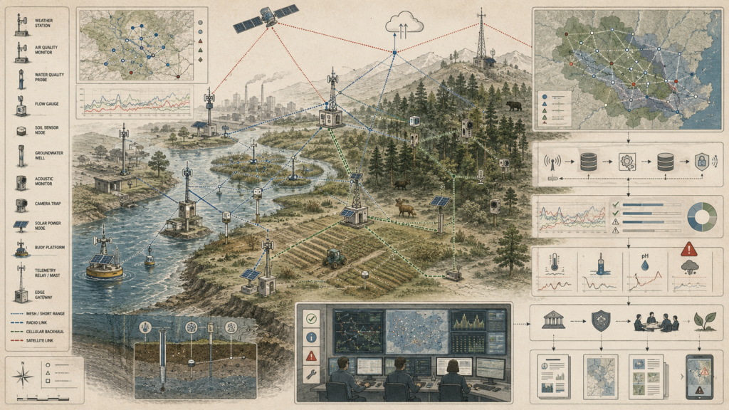
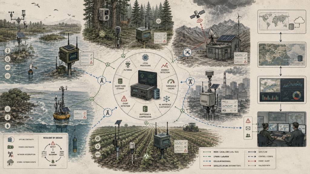
Edge computing makes environmental monitoring more resilient by moving computation closer to the environments being observed. Instead of sending every raw signal to distant platforms, field sensors, gateways, and rugged edge devices can filter data, detect anomalies, check thresholds, buffer records, assess device health, and issue local alerts in real time. This article examines how edge architectures support monitoring across rivers, wetlands, forests, farms, coasts, cities, and remote field stations where bandwidth, power, weather, and connectivity may be unreliable. Edge systems do not replace cloud platforms; they strengthen them by reducing latency, preserving continuity, prioritizing critical events, and supporting adaptive sampling. By linking local processing, resilient networks, environmental IoT, analytics, and decision support, edge computing turns distributed sensing into real-time environmental intelligence.

Embedded environmental monitoring devices deployed across field sites with sensors, probes, data logging, telemetry, device-health checks, and reliability indicators.

Embedded Monitoring Devices for Field Observation: Edge Sensing, Reliability, and Field Data Integrity

Embedded monitoring devices make field observation trustworthy by combining rugged sensing hardware with local processing, reliable power, telemetry, and data-integrity controls. Water-quality probes, soil sensors, weather stations, buoy systems, camera traps, acoustic monitors, and solar-powered field nodes must operate in harsh environments where moisture, sediment, heat, wildlife, battery limits, and intermittent connectivity can compromise evidence. This article examines how embedded devices support environmental monitoring through calibration, timestamping, sampling intervals, local logging, buffering, watchdog checks, power management, environmental sealing, telemetry status, and validation routines. Field data integrity depends not only on the sensor reading, but on the full embedded system that records, protects, checks, and transmits that observation. By linking edge sensing, device health, reliability engineering, and evidence quality, embedded monitoring devices become foundations for credible environmental intelligence.

Distributed environmental sensor network diagram showing weather stations, water probes, soil sensors, camera traps, telemetry links, dashboards, reporting pathways, and accountability systems.

Environmental Sensor Networks: Distributed Sensing, Telemetry, and Environmental Accountability

Environmental sensor networks make environmental conditions observable, traceable, and accountable across distributed landscapes. Weather stations, air-quality monitors, water-quality probes, flow gauges, soil sensors, groundwater wells, acoustic monitors, camera traps, buoys, solar-powered nodes, telemetry masts, and edge gateways collect signals from rivers, wetlands, forests, farms, coasts, cities, and remote field sites. This article examines how distributed sensing becomes environmental accountability when observations are connected through mesh links, radio telemetry, cellular backhaul, satellite relays, data-quality checks, threshold alerts, audit trails, operations review, and public reporting. Sensor networks are not valuable simply because they expand measurement; they matter when they produce reliable evidence that can support stewardship, compliance, restoration, early warning, maintenance, and institutional responsibility. By linking field observation to reviewable action, environmental sensor networks help turn ecological conditions into public knowledge.

Land use monitoring diagram showing satellite observation, landscape mosaics, land-cover classification, change detection, field validation, reporting, and accountability pathways.

Land Use Monitoring and Environmental Change Detection: Landscape Change, Classification, and Environmental Accountability

Land use monitoring makes landscape change visible, measurable, and accountable. Forest loss, wetland conversion, agricultural expansion, road building, industrial activity, peri-urban growth, restoration, and habitat fragmentation are not isolated visual changes; they are transformations in land systems that affect biodiversity, water, carbon, livelihoods, risk, and public responsibility. This article examines how satellite observation, aerial imagery, field validation, land-cover classification, temporal comparison, change matrices, false-color imagery, and disturbance mapping help detect where landscapes are changing and how quickly. Land use monitoring becomes environmentally meaningful when classification and change detection are connected to planning review, regulatory oversight, restoration priorities, compliance assessment, and public reporting. By linking landscape evidence to institutional accountability, environmental monitoring helps determine whether land transformation supports stewardship or accelerates ecological harm.

Ecosystem monitoring diagram showing habitats, species observations, field sensors, biodiversity plots, ecological indicators, data layers, restoration actions, and accountability pathways.

Ecosystem Monitoring and Ecological Observation: Condition, Function, and Ecological Accountability

Ecosystem monitoring makes ecological condition, function, and accountability visible across living systems. Forests, wetlands, rivers, grasslands, agricultural edges, coastal habitats, soils, species populations, and hydrologic flows are not separate observations; they are connected parts of ecological systems that change through disturbance, recovery, management, and climate pressure. This article examines how field stations, biodiversity plots, camera traps, acoustic sensors, water-quality probes, soil monitoring, transects, remote sensing, and field observation help assess habitat condition, species presence, ecosystem productivity, connectivity, thresholds, and resilience. Ecological observation becomes accountable when evidence is linked to conservation planning, restoration priorities, regulatory oversight, adaptive management, public reporting, and stewardship decisions. By connecting ecological data to reviewable action, ecosystem monitoring supports responsibility for the health and function of living systems.

Biodiversity monitoring diagram showing species observations, habitat sensors, field researchers, ecological indicators, conservation planning, restoration, and accountability pathways.

Biodiversity Monitoring Systems: Ecological Observation, Indicators, and Conservation Accountability

Biodiversity monitoring turns species observations into evidence for conservation accountability. Birds, mammals, amphibians, fish, insects, pollinators, plants, habitats, and ecological communities cannot be protected through isolated sightings alone; they require connected observation systems that track condition, distribution, abundance, movement, habitat quality, and change over time. This article examines how camera traps, acoustic sensors, transects, field surveys, water sampling, insect traps, remote sensing, ecological indicators, and geospatial analysis help assess biodiversity across forests, wetlands, rivers, grasslands, agricultural edges, and protected landscapes. Monitoring becomes meaningful when biodiversity evidence informs conservation planning, habitat restoration, protected-area management, policy review, adaptive management, and public reporting. By linking ecological observation to reviewable stewardship decisions, biodiversity monitoring helps make conservation responsibility measurable, transparent, and accountable.

Institutional soil monitoring diagram showing agricultural fields, soil profiles, field sensors, telemetry, satellite observation, data layers, and land stewardship pathways.

Soil Monitoring Systems and Agricultural Sensing

Soil monitoring systems connect agricultural sensing to soil health, field data integrity, and long-term land stewardship. Moisture probes, temperature sensors, pH and electrical conductivity instruments, nutrient sampling, weather stations, telemetry nodes, drone imagery, satellite observation, and field surveys help reveal what is happening above and below the soil surface. This article examines how soil profiles, root zones, organic matter, microbial activity, compaction, salinity, erosion risk, infiltration, crop stress, and groundwater conditions can be monitored as part of an integrated agricultural sensing architecture. Reliable soil intelligence depends on calibration, sampling design, metadata, validation, local buffering, remote sensing, and accountable interpretation. By linking embedded field devices, geospatial evidence, data-quality checks, and management decisions, soil monitoring supports agricultural resilience, restoration, environmental accountability, and responsible stewardship of productive land.

Smart water systems diagram showing rivers, reservoirs, treatment facilities, groundwater sensors, pipelines, telemetry networks, alerts, analytics, and adaptive water management.

Smart Water Systems and Environmental Sensing: Monitoring, Telemetry, and Adaptive Water Intelligence

Smart water systems transform water monitoring into adaptive intelligence across rivers, reservoirs, groundwater, wetlands, treatment facilities, irrigation networks, and urban infrastructure. Sensors, telemetry nodes, water-quality probes, level gauges, flow meters, pipeline monitors, and treatment controls help make water conditions visible across both ecological and engineered systems. This article examines how smart water architectures connect hydrologic observation, infrastructure oversight, analytics, alerts, and decision support to detect contamination, manage scarcity, monitor treatment performance, reduce losses, and respond to flood or drought risk. Water intelligence is not only about automation; it depends on data quality, interoperability, institutional coordination, and ecological awareness. By linking monitoring, telemetry, anomaly detection, governance review, and adaptive management, smart water systems support more resilient, accountable, and environmentally informed water stewardship.

Flood monitoring systems diagram showing rainfall radar, river gauges, reservoir sensors, groundwater wells, soil moisture, inundation maps, telemetry links, alerts, and coordinated flood response.

Flood Monitoring Systems and Hydrological Risk Detection

Flood monitoring systems turn hydrological signals into early evidence of risk. Rainfall radar, satellites, rain gauges, weather stations, river and stream gauges, reservoir sensors, soil-moisture probes, groundwater wells, stormwater monitors, pump stations, and telemetry networks help reveal how water moves through watersheds before, during, and after flood events. This article examines how flood intelligence depends on linking precipitation, runoff, infiltration, soil saturation, river stage, groundwater flow, infrastructure stress, inundation extent, thresholds, forecasts, and alerts. Effective flood monitoring is not only about detecting rising water; it is about creating actionable time for warning, coordination, evacuation, infrastructure protection, emergency response, and adaptive watershed management. By connecting hydrological observation to decision pathways, flood monitoring supports public safety, resilience, and accountable water stewardship.

Scroll to Top