
Last Updated May 14, 2026
Land use monitoring and environmental change detection are infrastructures of selective landscape visibility through which dynamic land systems become measurable, comparable, and governable across time and space. They combine satellite imagery, aerial observation, field reference data, time-series analysis, classification systems, validation frameworks, geospatial platforms, and policy-linked indicators in order to detect conversion, intensification, fragmentation, degradation, recovery, and shifting land condition. In this sense, land-use monitoring is not merely the production of maps. It is the disciplined construction of temporal evidence about how landscapes are transformed, how those transformations accumulate, and how they become administratively, scientifically, and politically real.
Land systems present a distinctive monitoring problem because they change through both abrupt transitions and slower cumulative processes. Forest can become cropland in a single clearing event, but it can also degrade through repeated disturbance, fragmentation, partial canopy loss, drought stress, fire, or selective harvest while still remaining nominally classified as forest. Cropland can intensify without changing broad category. Wetlands can be drained, compressed, disconnected, or hydrologically altered before disappearing from a map. Urbanization can occur through edge expansion, infill, road building, impervious-surface growth, and infrastructure spread rather than through one dramatic conversion. Effective land-use monitoring therefore depends not only on classification, but on temporal consistency, change logic, validation, uncertainty reporting, and the ability to distinguish genuine transformation from seasonal variation, sensor difference, atmospheric noise, and classification instability.
The deeper significance of land-use monitoring lies in the fact that it mediates between landscape reality and institutional claim. Carbon accounting, biodiversity protection, watershed management, land degradation assessment, restoration, agricultural governance, infrastructure planning, disaster risk reduction, and urban development increasingly depend on measurable evidence of land transformation. Yet the evidence produced by monitoring is always inferential. Landscapes do not present themselves directly as stable administrative categories. They are interpreted through classification systems, spectral signals, time-series models, reference samples, transition rules, accuracy assessments, and thresholds of change. Where monitoring is strong, land transformation becomes harder to obscure and easier to govern. Where it is weak, mapped stability can conceal environmental deterioration, and administrative categories can outlast ecological reality.
Main Library
Publications
Article Map
Environmental Monitoring
Related Topic
Remote Sensing
Related Topic
Data Systems
Related Topic
Risk & Resilience
Land-use monitoring is where environmental observation becomes historical landscape evidence. A single land-cover map records a surface at one moment; a monitoring system interprets change through time. It asks not only what a landscape appears to be, but how it has shifted, how reliable that interpretation is, what remains uncertain, and what public, scientific, or governance claim the evidence can support. The central question is not simply whether a classifier can assign categories. It is whether a monitoring system can distinguish landscape transformation from seasonal noise, classification error, sensor variation, and administrative simplification.
Engineering Problem
The engineering problem is how to design land-use monitoring systems that can detect meaningful landscape change while preserving temporal comparability, classification validity, spatial resolution, reference-data integrity, uncertainty visibility, and accountability for how land categories are translated into environmental claims. Land-change systems do not simply classify pixels. They construct change evidence by comparing observations across time, harmonizing sensors and seasons, distinguishing persistent transformation from transient variation, validating classifications against reference data, and linking mapped change to ecological, carbon, planning, or governance use.
This problem is difficult because landscapes do not change only by switching cleanly from one class to another. Forest degradation, wetland drying, cropland intensification, rangeland decline, urban infill, peri-urban expansion, mining disturbance, post-fire recovery, infrastructure fragmentation, soil exposure, and restoration trajectories often occur within or across categories in ways that a simple before-and-after map cannot fully represent. A land-cover class may remain stable while ecological condition changes. A spectral signal may shift because of drought, phenology, fire, flood, management, harvest, sensor geometry, atmospheric correction, or classification noise. A change map may look precise while still depending on uncertain class boundaries and validation assumptions.
Weak land-monitoring systems treat change detection as a visual difference between maps. Strong systems treat it as a disciplined evidence chain. They ask which categories are being used, whether land cover and land use are being conflated, how training and reference samples are selected, how cross-year consistency is protected, how uncertainty is reported, how condition change is detected, how fragmented landscapes are represented, how area estimates are corrected for map error, and whether the monitoring output can support the claim being made. The system succeeds only when mapped change, validation logic, and decision use remain aligned.
| Engineering Tension | Why It Matters | Required Evidence |
|---|---|---|
| Classification versus condition | Broad land-cover classes can remain stable while ecological function, canopy structure, moisture, or management intensity changes. | Condition indicators, spectral-change metrics, trajectory analysis, field validation |
| Resolution versus comparability | Higher spatial detail may reveal local change but complicate long-term comparison across sensors and products. | Resolution statement, harmonization method, sensor lineage, scale limits |
| Annual products versus seasonal dynamics | Land class may vary seasonally, especially in agriculture, wetlands, snow, drought, and disturbance contexts. | Seasonal window, phenology controls, compositing method, temporal caveats |
| Change detection versus change explanation | Detecting that change occurred does not establish why it occurred or what ecological consequence followed. | Driver context, ancillary data, field evidence, attribution caveat |
| Map area versus adjusted area | Pixel counts can be biased when classification error is not accounted for. | Accuracy assessment, reference sample, confusion matrix, area-adjustment method |
| Global consistency versus local meaning | Standard legends support comparison but may flatten locally important land-use and tenure realities. | Legend crosswalk, local interpretation notes, class-definition documentation |
| Monitoring visibility versus governance capacity | Seeing land transformation does not guarantee institutions can respond fairly or effectively. | Decision-use statement, reporting pathway, accountability log, public caveats |
The practical question is therefore: can the monitoring system distinguish meaningful land transformation from classification instability, and can it support the environmental claim attached to the map?
Reference Architecture
A practical land-use monitoring architecture can be understood as a time-series landscape evidence system. The exact implementation may include Landsat, Sentinel, aerial imagery, drone surveys, field plots, training samples, reference datasets, national land-cover products, global land-cover grids, classification models, change algorithms, spectral indices, fragmentation metrics, validation workflows, geospatial databases, dashboards, reporting systems, and policy indicators. The responsibilities remain consistent: observe, preprocess, classify, detect change, validate, estimate area, communicate uncertainty, link to decision use, and preserve evidence lineage.
| Layer | Engineering Role | Primary Risk | Evidence Artifact |
|---|---|---|---|
| Monitoring objective layer | Defines land process, geography, temporal horizon, class system, change question, and decision use. | Monitoring product optimized for map production rather than environmental accountability. | Monitoring objective manifest, decision-use statement, class legend |
| Observation layer | Acquires satellite, aerial, drone, or field observations with known spatial, spectral, and temporal properties. | Sensor differences, cloud, shadows, phenology, atmospheric effects, or acquisition gaps distort change. | Imagery inventory, acquisition log, sensor lineage, cloud mask |
| Preprocessing and harmonization layer | Corrects, masks, composites, aligns, and normalizes observations for comparison across time. | Apparent change is produced by processing differences rather than landscape transformation. | Preprocessing manifest, compositing method, harmonization notes |
| Classification layer | Assigns land-cover, land-use, or condition categories using rules, supervised learning, indices, or hybrid models. | Category confusion, class imbalance, weak training data, poor transfer across regions. | Classifier manifest, training data, class definitions, model card |
| Change-detection layer | Identifies transitions, disturbances, persistence, recovery, fragmentation, intensification, or condition shifts. | Seasonal variation, noise, and classification instability are mistaken for real change. | Change-rule registry, transition matrix, trajectory table |
| Validation and accuracy layer | Tests classification and change claims using independent reference data and uncertainty methods. | Maps appear precise while accuracy, bias, and uncertainty remain hidden. | Reference sample, confusion matrix, accuracy report, adjusted area estimate |
| Indicator and reporting layer | Converts land-change evidence into carbon, biodiversity, watershed, degradation, restoration, or planning indicators. | Indicators exceed the strength of the underlying classification and validation evidence. | Indicator specification, caveat statement, reporting methodology |
| Governance and accountability layer | Connects land-change evidence to public reporting, review, regulatory use, restoration claims, and dispute resolution. | Mapped categories become authoritative without transparent evidence lineage or public contestability. | Governance log, public evidence package, revision history |
This architecture makes clear that land-use monitoring is not only a remote-sensing task. It is an evidence infrastructure that depends on temporal design, classification discipline, validation, uncertainty communication, and governance.
Implementation Pattern
A rigorous land-monitoring implementation begins with the environmental and governance question. The correct approach depends on whether the system is meant to monitor deforestation, agricultural expansion, wetland loss, urban growth, impervious-surface change, land degradation, restoration, carbon flux, habitat fragmentation, watershed condition, wildfire recovery, drought stress, or compliance with land-management commitments. Each purpose implies different spatial resolution, temporal frequency, class definitions, validation needs, reference data, uncertainty reporting, and acceptable error.
| Artifact | Purpose | Suggested Format |
|---|---|---|
| Monitoring objective manifest | Defines monitored geography, land process, class system, temporal window, decision use, and evidence standard. | YAML, Markdown, architecture decision record |
| Land-class legend and crosswalk | Documents land-cover, land-use, condition, and reporting categories, including crosswalks across products. | CSV, JSON, controlled vocabulary |
| Imagery and observation inventory | Records source imagery, sensors, dates, cloud masks, preprocessing steps, and exclusions. | CSV, STAC catalog, geospatial metadata |
| Training and reference sample registry | Tracks sample locations, labels, source methods, temporal validity, and independence from training data. | CSV, GeoPackage, GeoJSON |
| Classification manifest | Documents model type, features, indices, training method, version, class imbalance handling, and intended use. | YAML, model card, notebook |
| Change-rule registry | Defines meaningful transitions, persistence rules, disturbance thresholds, recovery rules, and uncertainty flags. | CSV, YAML, transition table |
| Accuracy assessment package | Documents confusion matrix, user’s accuracy, producer’s accuracy, overall accuracy, uncertainty, and area adjustment. | CSV, report, notebook |
| Landscape metric outputs | Tracks fragmentation, patch size, edge density, impervious expansion, canopy loss, or recovery indicators. | CSV, raster, vector, notebook |
| Public evidence package | Explains methods, classes, uncertainty, limits, validation, and governance use for non-specialist interpretation. | Markdown, HTML, PDF, dashboard note |
| Governance and revision log | Records product updates, classification revisions, validation changes, reporting caveats, and disputed interpretations. | CSV, SQL table, changelog |
The implementation goal is to make landscape claims reconstructable. Users should be able to move from a reported land-change statistic back to the imagery, classification logic, reference data, validation method, transition rule, uncertainty statement, and decision context that produced it.
Research-Grade Framing: Land Monitoring as Landscape Knowledge Infrastructure
A research-grade account of land-use monitoring begins by treating it as landscape knowledge infrastructure rather than image processing alone. Monitoring systems determine which kinds of change become visible, which categories are recognized, how cross-year comparability is preserved, what counts as a significant transition, and which landscape transformations become reportable to planners, regulators, scientists, communities, and policymakers. In that sense, land monitoring organizes the conditions under which landscape change becomes knowable.
This role is epistemically difficult because landscapes are only partially observable in direct terms. Remote sensing reveals surface properties and their change, but the meaning of those changes depends on classification design, temporal context, ecological interpretation, field evidence, ownership and management context, and often ground reference. A spectral shift can indicate harvest, fire, drought stress, regrowth, conversion, flooding, drainage, mining, crop rotation, or classification ambiguity. A stable class label can conceal important change in management intensity or ecological condition. Monitoring therefore works through inference: repeated observations are translated into classes, transitions, trajectories, and condition signals that become intelligible enough for governance.
This inferential chain is not neutral. What is consistently classified and reported gains institutional weight. What remains difficult to observe, poorly validated, or weakly standardized may remain ecologically important yet administratively marginal. Land-use monitoring therefore does not simply reveal transformation. It helps determine which transformations become administratively real and which remain easier to overlook.
| Limited Pattern | Stronger Pattern | Why the Shift Matters |
|---|---|---|
| Produce a map | Construct a validated, time-consistent land-change evidence system | Prevents static cartography from being mistaken for monitoring. |
| Classify land cover | Distinguish cover, use, condition, management, disturbance, and recovery where needed | Prevents broad categories from hiding functional change. |
| Compare two dates | Analyze trajectories, persistence, repeated disturbance, and cumulative change | Captures gradual and episodic change that two-date comparison may miss. |
| Report pixel counts | Use validation, uncertainty, and area-adjusted estimates | Prevents classification error from becoming reporting error. |
| Publish land statistics | Preserve method, class definitions, confidence, validation, and caveats | Supports public accountability and contestability. |
| Treat land classes as reality | Treat classes as useful representations with boundaries and consequences | Protects ecological complexity from administrative simplification. |
The central research question is not “Can this system classify land?” but “What kind of landscape transformation does this monitoring system make visible, with what uncertainty, and for what governance purpose?”
Formal Model: Classification, Change, Validation, and Landscape Evidence Quality
A useful formal model separates classification accuracy, temporal consistency, change confidence, reference-data strength, condition sensitivity, fragmentation visibility, and reporting readiness. Let \(A_c\) represent classification accuracy, \(T_c\) temporal consistency, \(P_{\mathrm{change}}\) change confidence, \(V_r\) reference-data strength, \(S_{\mathrm{condition}}\) condition sensitivity, \(F_{\mathrm{fragmentation}}\) fragmentation visibility, \(U_c\) uncertainty communication, and \(R_g\) reporting/governance readiness. Land-change evidence quality depends on these dimensions together, not simply on a finished map.
A_{\mathrm{overall}} = \frac{N_{\mathrm{correctly\ classified}}}{N_{\mathrm{reference\ samples}}}
\]
Interpretation: Overall accuracy measures the share of reference samples correctly classified, but it should be interpreted alongside class-specific accuracy and sampling design.
C_{\mathrm{change}} = \frac{N_{\mathrm{validated\ change\ samples}}}{N_{\mathrm{detected\ change\ samples}}}
\]
Interpretation: Change confidence increases when detected change is supported by reference data, temporal logic, or independent evidence rather than by map differencing alone.
R_{\mathrm{persistence}} = \frac{N_{\mathrm{persistent\ change\ observations}}}{N_{\mathrm{change\ observations}}}
\]
Interpretation: Persistence ratio helps distinguish durable landscape transition from seasonal variation, temporary disturbance, or classification noise.
F_{\mathrm{edge}} = \frac{L_{\mathrm{class\ boundary}}}{A_{\mathrm{class}}}
\]
Interpretation: Edge density can be used as a simplified fragmentation indicator, showing how much class boundary exists relative to class area.
E_{\mathrm{area}} = \left|A_{\mathrm{map}} – A_{\mathrm{adjusted}}\right|
\]
Interpretation: Area-estimation error compares raw mapped area with accuracy-adjusted area, highlighting why pixel counts should not automatically be treated as truth.
Q_{\mathrm{land\ evidence}} = w_1A_c + w_2T_c + w_3P_{\mathrm{change}} + w_4V_r + w_5S_{\mathrm{condition}} + w_6F_{\mathrm{fragmentation}} + w_7U_c + w_8R_g
\]
Interpretation: Land evidence quality depends on classification accuracy, temporal consistency, validated change logic, reference data, condition sensitivity, fragmentation visibility, uncertainty communication, and governance readiness.
This formal structure protects against a common error in land monitoring: treating a mapped category as if it were the landscape itself. Land-monitoring evidence becomes stronger when classification, change detection, validation, uncertainty, and reporting purpose are evaluated together.
What Are Land Use Monitoring and Environmental Change Detection?
Land use monitoring refers to the repeated observation and interpretation of how land is occupied, managed, allocated, or transformed over time. Environmental change detection refers to the analytical process of identifying meaningful change in land cover, land use, land condition, landscape structure, or surface characteristics from sequential observations. Together, they form the observational basis for understanding how landscapes evolve under pressures such as urban expansion, agricultural intensification, forest loss, wildfire, drainage, mining, abandonment, restoration, infrastructure development, and climate stress.
Such systems may include satellite and aerial imagery, drone observations, field reference data, historical maps, time-series land-cover and land-change products, classification and change-detection algorithms, spectral indices, landscape metrics, ground validation, uncertainty assessment, and geospatial platforms for visualization, comparison, reporting, and governance. National systems such as Annual NLCD and land-change monitoring programs, global products such as ESA and Copernicus land-cover datasets, and cloud tools such as SEPAL all show how land observation increasingly depends on repeatable, scalable, and documented workflows rather than isolated mapping exercises.
The defining feature of land-use monitoring is temporal interpretation. A single map shows a landscape at one moment. Monitoring shows how that landscape changes, how quickly it changes, how change propagates through space, and whether observed shifts represent one-time transition, repeated disturbance, slow deterioration, intensification, fragmentation, or recovery. It is this temporal logic that transforms cartography into environmental evidence.
| Monitoring Form | Primary Question | Typical Evidence | Main Risk |
|---|---|---|---|
| Land-cover classification | What physical cover is present? | Forest, cropland, wetland, water, urban, grassland, barren, snow/ice classes | Surface cover is mistaken for land use or ecological condition. |
| Land-use interpretation | How is land managed or functionally used? | Agriculture, forestry, settlement, grazing, conservation, infrastructure, mining | Human purpose is inferred from surface appearance without supporting context. |
| Change detection | Where and when did land transition or disturbance occur? | Transition matrices, change maps, disturbance dates, before/after comparisons | Classification noise or seasonal variation is mistaken for durable change. |
| Condition monitoring | How is land functioning within a class? | Canopy density, vegetation index, impervious fraction, wetness, productivity, soil exposure | Stable classes conceal degradation, intensification, or recovery. |
| Trajectory analysis | What sequence of change has occurred over time? | Time series, disturbance/recovery paths, persistence ratios, change frequency | Complex histories are simplified into a single transition label. |
| Landscape-pattern analysis | How is land arranged spatially? | Patch size, edge density, fragmentation, connectivity, corridor metrics | Pattern is interpreted without ecological or social process context. |
Land-use monitoring is therefore more than surface mapping. It is a structured method for producing evidence about landscape transformation, persistence, degradation, recovery, and accountability.
Why Land Use Monitoring Matters
Land-use monitoring matters because land transformation is one of the clearest ways human systems reshape ecological and climatic conditions. Changes in forests, croplands, wetlands, settlements, rangelands, peatlands, coastlines, mines, transportation corridors, and infrastructure surfaces alter carbon storage, runoff, evapotranspiration, habitat continuity, soil exposure, heat balance, wildfire risk, flood behavior, biodiversity, and exposure to hazards. These changes matter not only because land classes shift, but because landscape function changes with them.
It also matters because not all land change is abrupt or visually obvious. A landscape may remain nominally agricultural while intensifying, drying, fragmenting, or degrading. A forest may remain mapped as forest while undergoing repeated harvest, fire, regrowth, pest disturbance, or canopy thinning. A wetland may remain delineated while hydrological condition erodes. A settlement may expand through small increments that collectively reshape water, heat, transport, and habitat. Monitoring is therefore necessary not only for detecting conversion, but for detecting transformations within categories that matter ecologically and politically even when class labels remain stable.
Monitoring additionally matters because land governance increasingly depends on measurable evidence. Carbon inventories, biodiversity strategies, watershed protection, climate reporting, restoration claims, land-degradation assessments, agricultural policy, urban planning, and infrastructure investment all require defensible information about land dynamics. Where monitoring is strong, claims about deforestation, restoration, cropland expansion, wetland loss, impervious growth, or degradation become more testable. Where it is weak, uncertainty can shield environmentally consequential change behind anecdote, fragmented jurisdiction, outdated land categories, or selective reporting.
| Need | Monitoring Contribution | Risk Without Monitoring |
|---|---|---|
| Carbon accounting | Tracks forest, cropland, grassland, wetland, settlement, and land-use-change patterns. | Carbon sinks and emissions from land conversion remain poorly estimated. |
| Biodiversity protection | Reveals habitat loss, fragmentation, degradation, and recovery trajectories. | Habitat decline can proceed beneath broad or outdated categories. |
| Watershed management | Links land cover, impervious surface, riparian condition, and runoff risk. | Land transformation is disconnected from water-quality and flood impacts. |
| Urban planning | Measures settlement expansion, infill, impervious growth, heat exposure, and infrastructure spread. | Incremental land conversion becomes normalized and undercounted. |
| Restoration evaluation | Assesses whether recovery claims are reflected in persistent landscape condition and trajectories. | Restoration claims become difficult to verify beyond project reports. |
| Land degradation assessment | Identifies declining cover, productivity, fragmentation, soil exposure, and disturbance recurrence. | Functional decline remains hidden behind stable class labels. |
| Public accountability | Makes land transformation visible enough for institutions, communities, and researchers to contest or verify claims. | Landscape change remains easier to minimize, dispute, or delay. |
Land-use monitoring matters because landscapes are long-lived public evidence systems. What happens to land can shape climate, water, habitat, livelihoods, and infrastructure for decades.
Land Monitoring as Landscape Knowledge Infrastructure
A deep understanding of land-use monitoring requires treating it as landscape knowledge infrastructure rather than as image processing alone. Monitoring systems determine which kinds of change become visible, which categories are recognized, how cross-year comparability is preserved, what counts as a significant transition, and which landscape transformations become reportable to planners, regulators, scientists, communities, and policymakers. In that sense, land monitoring organizes the conditions under which landscape change becomes knowable.
This role is epistemically difficult because landscapes are only partially observable in direct terms. Remote sensing reveals surface properties and their change, but the meaning of those changes depends on classification design, temporal context, ecological interpretation, and often ground reference. A spectral shift can indicate harvest, fire, drought stress, regrowth, conversion, flooding, drainage, bare-soil exposure, crop rotation, or classification ambiguity. A stable class label can conceal important change in management intensity or ecological condition. Monitoring therefore works through inference: repeated observations are translated into classes, transitions, trajectories, and condition signals that become intelligible enough for governance.
This inferential chain is not neutral. What is consistently classified and reported gains institutional weight. What remains difficult to observe, poorly validated, or weakly standardized may remain ecologically important yet administratively marginal. Land-use monitoring therefore does not simply reveal transformation. It helps determine which transformations become administratively real and which remain easier to overlook.
| Monitoring Choice | What Becomes More Visible | What May Remain Less Visible |
|---|---|---|
| Broad land-cover legend | National or global comparability across major classes. | Within-class degradation, local land-use meaning, management intensity. |
| Annual classification | Long-term trend, broad transition, and annual reporting. | Seasonal dynamics, short disturbance windows, temporary flooding or cropping cycles. |
| High-resolution imagery | Fine-grained urban growth, fragmentation, small clearings, riparian change. | Long historical continuity if comparable imagery is unavailable. |
| Spectral-change methods | Disturbance timing, vegetation loss, recovery, surface alteration. | Management, ownership, tenure, or social drivers of change. |
| Area-based reporting | National inventories, climate reporting, land-change summaries. | Spatial distribution, community exposure, ecological connectivity, patch structure. |
| Administrative reporting categories | Policy alignment, regulatory use, cross-jurisdictional accounting. | Ecological complexity and contested land meanings. |
Land monitoring is powerful because it gives landscapes a temporal record. It is risky when the record is mistaken for the full reality of land systems.
Land Use, Land Cover, Condition, and Change
Robust land monitoring requires distinguishing among several related but non-identical concepts. Land cover refers to the physical cover observed on the land surface, such as forest, cropland, water, grassland, wetland, snow, barren land, shrubland, or urban surfaces. It is often the most straightforward dimension to derive from remote sensing because it is closely tied to observable surface properties.
Land use refers more directly to the human purpose, management, allocation, or functional use of land, such as agriculture, forestry, settlement, conservation, grazing, mining, transportation, recreation, or infrastructure. Land use may align imperfectly with visible cover because similar covers can support different uses and similar uses can produce different covers depending on intensity, season, ownership, and management.
Land condition refers to the ecological or functional state of land within a class, including degradation, fragmentation, canopy thinning, productivity shifts, drying, soil exposure, altered hydrology, erosion, invasion, disturbance frequency, or recovery. Condition is often harder to monitor than cover because it is less directly reducible to one visible category.
Land change refers to transitions or trajectories across time, whether abrupt conversion, repeated disturbance, slow intensification, fragmentation, degradation, abandonment, restoration, regrowth, or recovery.
| Concept | Core Meaning | Common Evidence | Analytical Risk |
|---|---|---|---|
| Land cover | Physical surface cover visible or inferable from observation. | Satellite imagery, aerial imagery, spectral signatures, land-cover classes. | Surface appearance is treated as complete land meaning. |
| Land use | Human purpose, management, tenure, or function of land. | Administrative records, field data, land-management data, contextual interpretation. | Use is inferred from cover without enough social or management evidence. |
| Land condition | Ecological or functional state within or across classes. | Vegetation indices, canopy metrics, wetness, productivity, fragmentation, soil exposure. | Stable categories hide degradation or recovery. |
| Land change | Temporal transition, trajectory, disturbance, persistence, or recovery. | Time series, change maps, transition matrices, disturbance dates, trajectory classes. | Noise, phenology, or classification instability is mistaken for transformation. |
No single dimension is sufficient alone. Land cover can persist while condition erodes. Land use can intensify without an obvious class shift. Condition can deteriorate before a categorical transition is visible. Change can proceed through trajectory rather than abrupt conversion. Monitoring becomes strongest when it tracks not just what land is called, but how land is functioning, changing, and being used through time.
Key Analytical Distinctions
Land cover is not the same as land use. Surface appearance and human purpose may overlap, but they are not identical categories. Landscapes can be similar in cover while serving different uses, and similar uses can appear differently depending on management intensity, season, ecological context, and infrastructure.
Static mapping is not the same as monitoring. Monitoring requires repeated observation and temporal logic, not one-time classification. A single map shows pattern; monitoring reveals transformation.
Change detection is not the same as explanation. A monitoring system may identify that change occurred and when it occurred, yet still require additional contextual data to determine why it occurred and which drivers were responsible.
Classification certainty is not the same as ecological completeness. A highly consistent land-cover product can still miss degradation, fragmentation, intensification, hydrological change, or biodiversity decline that matters ecologically and politically.
Pattern is not the same as process. Remote sensing can reveal spatial arrangement and temporal surface change, but many land-system processes require interpretation through management, ecology, hydrology, climate, tenure, infrastructure, and field context.
Persistence is not the same as stability. A class label may remain constant while the landscape within that class becomes progressively thinner, simpler, drier, more fragmented, more disturbed, or less ecologically functional.
| Distinction | Why It Matters | Design Implication |
|---|---|---|
| Land-cover class versus ecological condition | Stable labels can conceal functional decline or recovery. | Add condition indicators, trajectory metrics, and validation samples. |
| Map comparison versus time-series monitoring | Two maps can show apparent change created by classification inconsistency. | Use temporal harmonization, persistence rules, and confidence flags. |
| Pixel count versus area estimate | Map error can bias raw area statistics. | Use reference samples and accuracy-adjusted area estimation. |
| Remote signal versus land-system driver | Spectral change does not automatically reveal cause. | Integrate field evidence, climate data, management context, and ancillary datasets. |
| Global legend versus local meaning | Global categories can erase local land-use complexity. | Use class crosswalks and local interpretive notes. |
| Monitoring visibility versus accountability | Mapped change does not automatically create institutional response. | Define reporting, review, public caveats, and governance pathways. |
These distinctions prevent land-use monitoring from being reduced to map production. The monitoring system is an evidentiary architecture, not merely a classification pipeline.
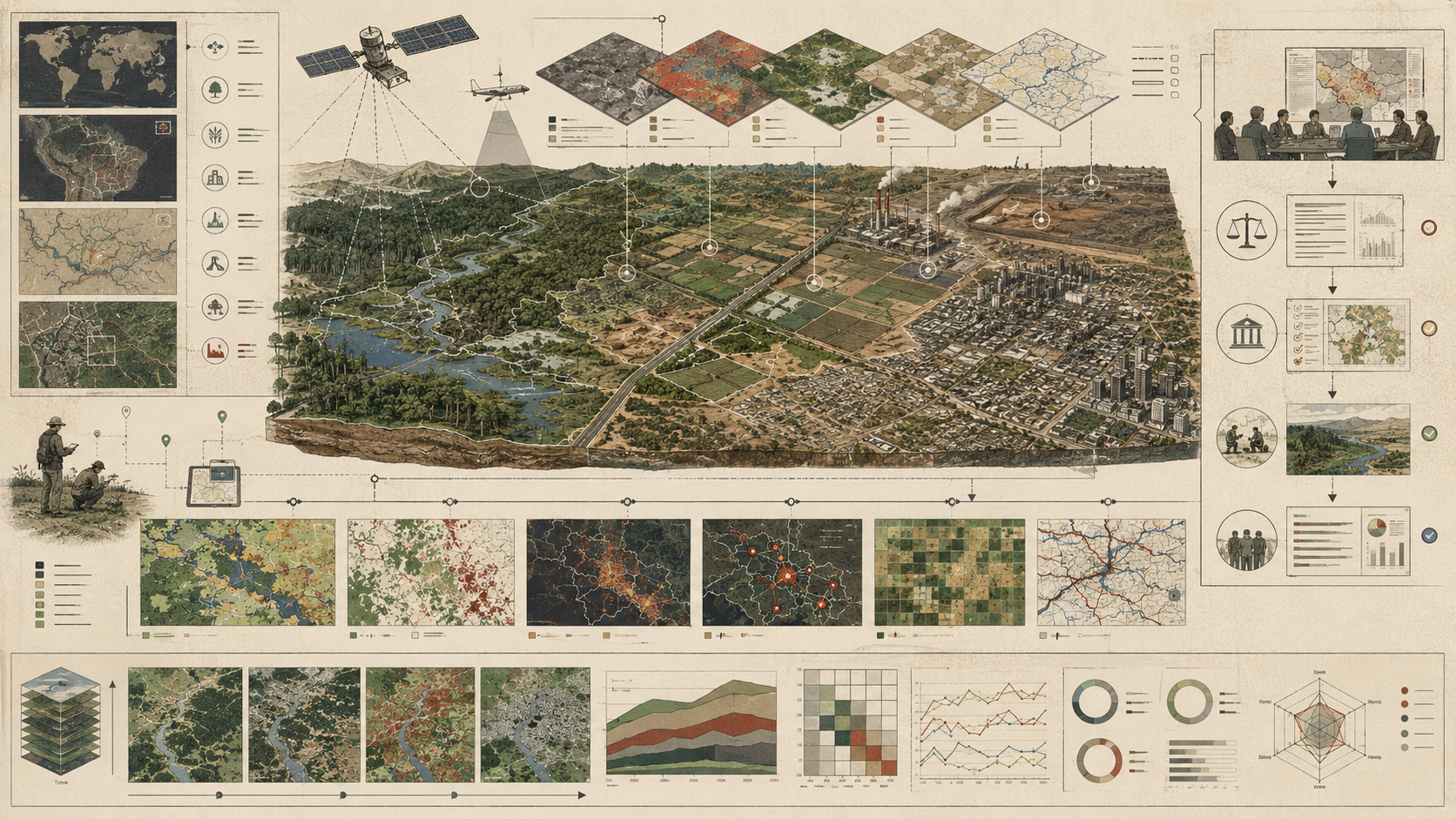
System Architecture: From Observation to Land-Change Intelligence
Land-use monitoring systems operate as layered architectures that transform repeated observations into interpretable land-change intelligence. Satellites, aircraft, drones, and ground systems collect repeated measurements of land surface characteristics. Imagery and ancillary data are time-stamped, georeferenced, masked, corrected, composited, and prepared for analysis. Algorithms, rule sets, and expert interpretation assign land classes or condition states. Time-series methods identify transitions, disturbances, persistence, and trajectories. Ground reference data and quality assessment constrain reliability and uncertainty. Analysts, agencies, communities, and policymakers then use results for inventories, planning, reporting, restoration, regulation, and governance.
| Stage | Transformation | Failure Risk |
|---|---|---|
| Landscape process | Land changes through conversion, disturbance, intensification, fragmentation, degradation, recovery, or management. | The selected variables fail to represent the process of concern. |
| Observation | Remote or field systems capture surface reflectance, structure, texture, condition, or reference labels. | Cloud, shadow, seasonality, sensor differences, missing acquisitions, or weak reference data. |
| Preprocessing | Data are corrected, masked, aligned, composited, normalized, and prepared for comparison. | Processing differences create apparent change. |
| Classification | Land classes, condition states, or disturbance labels are assigned. | Class confusion, poor training data, weak legend definitions, or regional transfer failure. |
| Change detection | Transitions, persistence, disturbance timing, recovery, and trajectories are identified. | Noise, phenology, temporary events, or map error are mistaken for durable transformation. |
| Validation | Independent reference data and accuracy methods test classification and change claims. | Outputs are reported without uncertainty, sample design, or class-specific accuracy. |
| Indicator production | Class and change outputs become carbon, biodiversity, degradation, watershed, or planning indicators. | Indicators exceed the evidence strength of the monitoring product. |
| Governance use | Monitoring outputs support reporting, regulation, restoration review, public communication, or accountability. | Categories become authoritative without transparency or contestability. |
This layered structure matters because land intelligence does not arise directly from imagery. It depends on classification systems, temporal harmonization, validation logic, and interpretive frameworks that turn repeated surface observations into claims about conversion, persistence, fragmentation, degradation, or recovery. Monitoring systems are therefore not just visual archives. They are interpretive machines for landscapes.
Remote Sensing, Time Series, and Ground Reference Data
Remote sensing is central to modern land-use monitoring because it enables repeated observation over large areas at consistent intervals. Long satellite archives make it possible to examine landscape trajectories across decades rather than isolated snapshots. Landsat is especially important because the NASA/USGS program provides the longest continuous space-based record of Earth’s land, and those data have been used to classify land cover, detect landscape change, and map the impacts of human activity on the environment. Annual NLCD builds on the Landsat record to provide long-term annual information about land cover and change across the United States, while USGS land-change programs frame land monitoring as the repeated assessment of land use, cover, and condition through time.
Global and regional land-cover systems extend this logic beyond one national context. Copernicus land-cover products provide global gridded classifications from satellite observations using FAO Land Cover Classification System classes and quality flags, while ESA’s Climate Change Initiative focuses on consistent global land-cover information for climate users. These products demonstrate an important principle: land-cover maps become more useful when they are paired with documentation, quality information, and consistent methodology rather than presented as self-explanatory images.
But remote sensing alone is not enough. Ground reference data remain essential because remote signals require calibration, validation, and local interpretation. A classifier may distinguish cropland from forest with high overall accuracy while still performing unevenly across ecotones, mixed landscapes, dynamic wetlands, post-disturbance forests, urban edges, or smallholder agricultural mosaics. Local field information helps determine whether observed change represents real transformation, temporary variation, management practice, or classification instability.
| Evidence Source | Contribution | Primary Limitation |
|---|---|---|
| Landsat time series | Long historical record for land-cover and land-change analysis. | Moderate spatial resolution, cloud and seasonal constraints, processing choices. |
| Sentinel imagery | Higher revisit frequency and strong complement to long-term archives. | Shorter historical record compared with Landsat. |
| Aerial or drone imagery | Fine spatial detail for local validation, restoration, urban, and ecological monitoring. | Limited coverage and comparability through time. |
| Ground reference data | Supports training, validation, accuracy assessment, and local interpretation. | Sampling bias, cost, temporal mismatch, and access constraints. |
| Administrative land records | Provides land-use, tenure, zoning, or management context. | May be outdated, incomplete, politically contested, or disconnected from cover. |
| Cloud geospatial platforms | Scale classification, change detection, area estimation, and reporting workflows. | Can obscure method choices if workflows are not documented and reproducible. |
The strongest monitoring systems combine remote sensing with ground reference, contextual data, and temporal logic. The problem is not simply to see more of the land surface, but to see enough of it consistently, interpretably, and honestly enough for change claims to be credible.
Change Trajectories, Fragmentation, and Environmental Signals
Environmental change detection is not merely the comparison of two dates. It is the interpretation of trajectories through time. A landscape may experience abrupt conversion, repeated disturbance, gradual intensification, fragmentation, decline in condition, recovery, or oscillation among states. Time-series systems are powerful precisely because they distinguish transient variation from sustained change and reveal the timing and sequencing of transformation.
This is especially important for fragmentation and degradation. Some environmental signals are not full class transitions but shifts in patch structure, connectivity, canopy dynamics, vegetation persistence, wetness, impervious fraction, or land-surface condition. A forest edge may advance without full forest loss; a wetland may shrink hydrologically before disappearing cartographically; a cropland system may intensify through repeated disturbance and irrigation changes while remaining classified as cropland; an urban area may expand through small impervious increments that do not register as a dramatic class transition in coarse products.
From a systems perspective, trajectories matter because environmental consequence often depends more on repeated and cumulative change than on one-time transition alone. Monitoring is strongest when it captures landscape history as process rather than land surface as a sequence of disconnected pictures.
| Trajectory Type | Example | Monitoring Signal | Accountability Question |
|---|---|---|---|
| Abrupt conversion | Forest to cropland, wetland to development, grassland to mine. | Class transition, spectral break, disturbance date. | Was the conversion permitted, reported, mitigated, or restored? |
| Repeated disturbance | Harvest cycles, fire recurrence, flood disturbance, grazing pressure. | Change frequency, disturbance sequence, recovery interval. | Is the landscape recovering or entering persistent disturbance? |
| Gradual degradation | Canopy thinning, soil exposure, wetland drying, rangeland decline. | Trend in condition index, productivity, wetness, or structure. | Does administrative stability conceal functional decline? |
| Fragmentation | Roads, edge growth, subdivision, small clearings. | Patch size, edge density, connectivity loss, corridor disruption. | Is habitat or landscape function being eroded without full conversion? |
| Intensification | More frequent cropping, irrigation change, infrastructure densification. | Phenology, disturbance frequency, impervious fraction, management signal. | Is land use changing while cover class remains stable? |
| Recovery or restoration | Reforestation, wetland restoration, mine reclamation, vegetation regrowth. | Persistent positive condition trajectory and class/structure recovery. | Does mapped recovery correspond to ecological recovery? |
Land-change monitoring becomes more credible when it records trajectories rather than only labels. A landscape’s history often matters as much as its current class.
Classification, Proxies, and the Limits of Representation
Land-use monitoring depends heavily on proxies. Surface reflectance, texture, phenology, thermal response, spatial configuration, vegetation indices, impervious fraction, wetness indices, canopy metrics, and other remotely observed properties are used to infer cover classes, condition shifts, or land-change events. This is unavoidable. Landscapes cannot be monitored comprehensively without indirect representation.
But proxies have limits. A land-cover class can be administratively stable while ecologically thin. A condition signal can suggest degradation without specifying mechanism. Fragmentation metrics can reveal pattern without fully resolving ecological effect. A spectral break can mark disturbance without identifying land-management driver. A map product can be highly useful for reporting while remaining only a partial representation of land-system reality. This is one of the deepest truths of land monitoring: landscapes always exceed their categories.
The task, then, is not to avoid proxies but to use them critically. Strong monitoring systems combine classes, change signals, condition metrics, reference data, and validation rather than mistaking any single layer for the landscape itself. They preserve an awareness that representation is selective and that administrative simplicity can sometimes be purchased at ecological cost.
| Proxy Signal | Possible Interpretation | Limit | Evidence Requirement |
|---|---|---|---|
| Vegetation index decline | Canopy loss, drought stress, harvest, fire, degradation, seasonal change. | Multiple processes can produce similar spectral response. | Time-series context, climate data, field reference, disturbance history. |
| Impervious-surface increase | Urban expansion, infrastructure growth, road development, land sealing. | Small increments may be difficult to validate or link to social impact. | High-resolution validation, planning context, watershed impact analysis. |
| Wetness change | Wetland drying, flooding, irrigation, drainage, seasonal moisture variation. | Hydrological meaning depends on season, climate, and landscape position. | Hydrological context, seasonal window, field or gauge data. |
| Patch fragmentation | Habitat fragmentation, edge expansion, connectivity loss. | Pattern does not automatically equal ecological effect. | Habitat model, species or ecosystem context, scale sensitivity. |
| Spectral break | Disturbance, clearing, fire, harvest, flooding, soil exposure. | Driver attribution remains uncertain without ancillary evidence. | Change date, field data, fire/harvest/flood records, local interpretation. |
| Class transition | Land-cover conversion or persistent management shift. | Transition can be produced by classification inconsistency. | Validation sample, confidence score, persistence rule, transition audit. |
Proxy variables are useful when they are treated as evidence with boundaries. They become dangerous when they are treated as direct knowledge of the whole landscape.
Classification Error, Temporal Consistency, and Uncertainty
One of the central challenges in land-use monitoring is uncertainty. Class boundaries can be ambiguous, seasonal variability can mimic change, sensors differ across time, training data can be biased, reference samples can be sparse, and algorithms may perform unevenly across regions and land systems. Accuracy is therefore never merely a one-time property of a map; it is an ongoing question of how stable classification and change logic remain through time.
Temporal consistency is especially important. A monitoring system can only support serious land-change analysis if its categories remain comparable across years and if its methods do not manufacture apparent change where none exists. Long-term land products are powerful not because they eliminate uncertainty, but because they manage it systematically through consistent rules, cross-year harmonization, documented processing, reference and validation data, confidence measures, and explicit quality information.
Strong monitoring systems therefore do not pretend uncertainty is absent. They expose it through validation, quality assessment, confidence flags, class-specific accuracy, uncertainty ranges, and careful interpretation of transition logic. This matters because land-governance claims can otherwise appear more certain than the evidence systems beneath them justify.
| Uncertainty Source | How It Enters the Evidence Chain | Mitigation |
|---|---|---|
| Class confusion | Similar spectral or structural signatures produce misclassification. | Class-specific validation, confusion matrix, improved reference data. |
| Seasonal variation | Phenology, flooding, snow, cropping, or drought mimic change. | Consistent seasonal windows, multi-date composites, temporal rules. |
| Sensor and processing differences | Observations differ due to sensor, atmospheric correction, resolution, or preprocessing. | Harmonization, preprocessing manifest, sensor lineage documentation. |
| Reference-data bias | Training or validation samples overrepresent accessible or obvious landscapes. | Sampling design, independent validation, uncertainty reporting. |
| Mixed pixels or boundary zones | One pixel contains multiple covers or lies along transitional edges. | Scale caveats, fractional cover, higher-resolution validation. |
| Change-rule instability | Transition logic differs through time or across products. | Rule registry, versioning, transition audit, persistence tests. |
| Proxy ambiguity | Observed signal has multiple possible ecological or management meanings. | Ancillary evidence, field interpretation, cautious claims. |
Uncertainty is not a weakness when it is made visible. It is a weakness when mapped categories are presented as if classification, validation, and interpretation were self-evident.
Governance, Reporting, and Landscape Accountability
Land-use monitoring has a governance dimension because what is classified and tracked shapes what can be regulated, reported, financed, restored, or contested. Carbon accounting, land-use-change reporting, urban planning, conservation, land-degradation assessment, climate adaptation, watershed protection, infrastructure planning, and restoration finance all depend on categories and change evidence that monitoring systems provide.
This makes land monitoring an infrastructure of accountability. A claim about deforestation, restoration, cropland expansion, wetland loss, impervious growth, or land degradation becomes more testable when supported by repeated observation and transparent change logic. Where monitoring is strong, landscape transformation becomes harder to obscure behind anecdote, fragmented jurisdiction, outdated administrative categories, or selective reporting.
Weak monitoring, by contrast, is a governance vulnerability. When change is poorly observed, mapped persistence can be mistaken for environmental stability. When condition is weakly represented, landscapes can appear administratively intact while functionally degraded. When cross-jurisdictional monitoring is inconsistent, environmentally important transformations may remain easier to minimize or delay in policy response. In that sense, uncertainty often does not fall evenly: it can shelter degradation more effectively than it shelters landscape integrity.
| Governance Responsibility | Question | Evidence |
|---|---|---|
| Class governance | Who defines land-cover, land-use, condition, and reporting categories? | Legend documentation, class definitions, crosswalk, public method note |
| Method governance | Are classification, change-detection, and preprocessing methods documented and versioned? | Method manifest, model card, code repository, revision history |
| Validation governance | Are accuracy, reference data, uncertainty, and adjusted estimates made visible? | Validation report, confusion matrix, reference sample, confidence flags |
| Reporting governance | Are land-change claims matched to evidence quality and uncertainty? | Reporting methodology, caveat statement, indicator specification |
| Public accountability | Can affected publics, researchers, and institutions understand and contest mapped claims? | Public evidence package, accessible metadata, documentation, reproducible workflow |
| Revision governance | How are errors, new reference data, classification updates, and product changes handled? | Changelog, versioned products, correction log, update notice |
| Equity and visibility governance | Which landscapes, communities, land systems, or tenure arrangements remain under-observed? | Coverage audit, representativeness review, local validation plan |
Governance is how land-use monitoring remains trustworthy after classification outputs enter reports, inventories, dashboards, policies, and public claims.
Future Directions
The future of land-use monitoring lies in tighter integration across satellite time series, drone imagery, ground reference data, cloud computing, classification systems, condition-sensitive change analysis, validation workflows, and public evidence systems. The opportunity is not only to produce more maps, but to build stronger systems for tracking trajectories, fragmentation, degradation, restoration, land-use intensity, and ecological condition with greater temporal and interpretive depth.
Artificial intelligence and cloud geospatial platforms will expand the scale and speed of land classification, change detection, area estimation, and anomaly review. They will also make governance more important. If models infer land transformation from large-scale imagery, the monitoring system must preserve training data, class definitions, model version, reference data, uncertainty, proxy limits, and validation context. Otherwise automated mapping may amplify category errors, underrepresent complex landscapes, or create a false sense of precision.
The deeper challenge is not simply collecting more imagery. It is building monitoring systems that distinguish land use from land cover where needed, track condition as well as class, preserve comparability through time, and communicate uncertainty honestly enough for governance to remain credible. The most important next step is likely not raw observational abundance, but better integration between landscape representation and landscape meaning.
Land transformation is often gradual enough to be normalized and broad enough to be politically diffused. Where monitoring systems are strong, that transformation becomes more measurable, more discussable, and more governable. Where they are weak, mapped stability can conceal environmental deterioration and administrative categories can outlast ecological reality. In that sense, land-use monitoring and environmental change detection are not merely mapping activities. They are infrastructures of selective visibility, landscape accountability, and environmental truth.
Deployment Readiness Gate
Before a land-use monitoring system is used for carbon accounting, biodiversity assessment, restoration claims, land-degradation reporting, urban planning, watershed management, climate reporting, compliance, or public communication, it should pass a deployment readiness gate. This gate should test whether the monitoring system is temporally consistent, validated, interpretable, uncertainty-aware, and fit for the governance claim attached to it.
| Readiness Area | Required Question | Pass Evidence |
|---|---|---|
| Purpose readiness | Does the system match the land process, geography, temporal horizon, decision use, and evidence standard? | Monitoring objective manifest, decision-use statement, reporting scope |
| Class readiness | Are land-cover, land-use, condition, and change categories clearly defined? | Class legend, class definitions, crosswalk, category caveats |
| Observation readiness | Are imagery, sensor lineage, acquisition windows, cloud masks, and preprocessing steps documented? | Observation inventory, preprocessing manifest, sensor lineage |
| Temporal readiness | Can the system distinguish persistent change from seasonal variation, temporary events, and classification noise? | Time-series method, persistence rule, compositing strategy, change-rule registry |
| Validation readiness | Are reference data, sampling design, accuracy, uncertainty, and area-estimation methods documented? | Reference sample, confusion matrix, validation report, adjusted area estimate |
| Condition readiness | Does the system capture within-class degradation, recovery, fragmentation, or intensification where needed? | Condition indicators, fragmentation metrics, trajectory outputs, field review |
| Uncertainty readiness | Are class confidence, change confidence, known errors, and interpretation limits visible? | Confidence layers, uncertainty statement, caveat note, validation appendix |
| Reporting readiness | Are map outputs linked to defensible carbon, biodiversity, degradation, restoration, or planning indicators? | Indicator specification, method note, reporting crosswalk |
| Governance readiness | Are public caveats, revision rules, dispute pathways, and accountability responsibilities defined? | Governance log, public evidence package, changelog, review owner |
This readiness gate prevents land-use monitoring from being treated as complete merely because a classification map exists. The stronger standard is whether the monitoring system can support a defensible claim about landscape change.
Data and Configuration Artifacts
A reproducible land-use monitoring workflow should include explicit artifacts for objectives, class definitions, imagery, preprocessing, classification, change rules, reference data, validation, uncertainty, indicators, and governance. These artifacts make land-change evidence auditable rather than hidden inside map products and interpretation decisions.
| Artifact | Purpose | Suggested Path |
|---|---|---|
| Monitoring objective manifest | Defines geography, land process, temporal window, decision use, class system, and evidence standard. | config/monitoring_objective.yml |
| Land-class legend | Documents land-cover, land-use, condition, transition, and reporting categories. | data/land_class_legend.csv |
| Imagery inventory | Tracks imagery source, sensor, acquisition date, cloud cover, preprocessing, and exclusions. | data/imagery_inventory.csv |
| Training and reference sample registry | Stores sample IDs, coordinates, labels, source, confidence, temporal validity, and validation role. | data/reference_samples.csv |
| Classification manifest | Documents model type, features, version, training data, class handling, and intended use. | config/classification_manifest.yml |
| Change-rule registry | Defines meaningful transitions, persistence logic, disturbance thresholds, and recovery rules. | data/change_rule_registry.csv |
| Land-change records | Stores location, prior class, current class, transition, confidence, persistence, and evidence status. | data/land_change_records.csv |
| Accuracy assessment | Stores confusion matrix, class accuracy, overall accuracy, adjusted area, and uncertainty fields. | data/accuracy_assessment.csv |
| Landscape metrics | Stores fragmentation, patch, edge, impervious, canopy, wetness, or condition metrics. | data/landscape_metrics.csv |
| Governance log | Tracks product updates, validation changes, public caveats, disputed claims, and revision decisions. | data/land_monitoring_governance_log.csv |
These artifacts turn land-use monitoring into a reproducible landscape evidence system rather than a static map production exercise.
Mathematical Lens: Classification Accuracy, Change Confidence, Fragmentation, and Accountability
Several simple metrics can help evaluate land-monitoring readiness. These metrics are not substitutes for field validation, remote-sensing expertise, sampling design, or governance judgment, but they make land-change evidence quality more inspectable.
A_{\mathrm{overall}} = \frac{N_{\mathrm{correctly\ classified}}}{N_{\mathrm{reference\ samples}}}
\]
Interpretation: Overall accuracy measures the share of reference samples classified correctly, but should be interpreted with class-specific accuracy and sample design.
C_{\mathrm{change}} = \frac{N_{\mathrm{validated\ change\ samples}}}{N_{\mathrm{detected\ change\ samples}}}
\]
Interpretation: Change confidence increases when detected change is supported by reference data, persistence logic, or independent evidence.
R_{\mathrm{persistence}} = \frac{N_{\mathrm{persistent\ change\ observations}}}{N_{\mathrm{change\ observations}}}
\]
Interpretation: Persistence ratio helps distinguish durable land transformation from seasonal variation, temporary disturbance, or classification noise.
F_{\mathrm{edge}} = \frac{L_{\mathrm{class\ boundary}}}{A_{\mathrm{class}}}
\]
Interpretation: Edge density can be used as a simplified indicator of fragmentation or patch dissection within a class.
E_{\mathrm{area}} = \left|A_{\mathrm{map}} – A_{\mathrm{adjusted}}\right|
\]
Interpretation: Area-estimation error compares mapped area with accuracy-adjusted area, highlighting why raw pixel counts should not automatically be treated as truth.
Q_{\mathrm{land\ evidence}} = w_1A_c + w_2T_c + w_3P_{\mathrm{change}} + w_4V_r + w_5S_{\mathrm{condition}} + w_6F_{\mathrm{fragmentation}} + w_7U_c + w_8R_g
\]
Interpretation: Land evidence quality depends on classification accuracy, temporal consistency, validated change logic, reference data, condition sensitivity, fragmentation visibility, uncertainty communication, and governance readiness.
These measures evaluate land-monitoring systems as evidence infrastructures rather than map catalogs. They ask whether classification, change detection, validation, uncertainty, and reporting context are strong enough to support the intended claim.
Python Workflow: Land-Change Readiness and Classification Accountability
A Python workflow can demonstrate how land-use monitoring systems might be evaluated for classification accuracy, temporal consistency, change confidence, reference-data strength, condition sensitivity, fragmentation visibility, uncertainty communication, and reporting readiness. The purpose is not to create a universal score, but to make land-evidence dimensions visible.
from dataclasses import dataclass
from typing import List
import pandas as pd

@dataclass
class LandMonitoringProduct:
    product_id: str
    geography: str
    monitoring_purpose: str
    classification_accuracy: float
    temporal_consistency: float
    detected_change_samples: int
    validated_change_samples: int
    reference_data_strength: float
    condition_sensitivity: float
    fragmentation_visibility: float
    uncertainty_communication: float
    reporting_readiness: float
    high_stakes_use: bool

def change_confidence(product: LandMonitoringProduct) -> float:
    if product.detected_change_samples <= 0:
        return 0.0
    return max(0.0, min(1.0, product.validated_change_samples / product.detected_change_samples))

def land_evidence_quality(product: LandMonitoringProduct) -> float:
    return (
        0.16 * product.classification_accuracy +
        0.14 * product.temporal_consistency +
        0.14 * change_confidence(product) +
        0.14 * product.reference_data_strength +
        0.12 * product.condition_sensitivity +
        0.10 * product.fragmentation_visibility +
        0.10 * product.uncertainty_communication +
        0.10 * product.reporting_readiness
    )

def classify_review_priority(product: LandMonitoringProduct, score: float) -> str:
    if product.high_stakes_use and product.classification_accuracy < 0.80:
        return "high_stakes_accuracy_review"
    if product.temporal_consistency < 0.75:
        return "temporal_consistency_review"
    if change_confidence(product) < 0.75:
        return "change_validation_review"
    if product.reference_data_strength < 0.75:
        return "reference_data_review"
    if product.condition_sensitivity < 0.70:
        return "condition_monitoring_review"
    if product.fragmentation_visibility < 0.70:
        return "fragmentation_visibility_review"
    if product.uncertainty_communication < 0.75:
        return "uncertainty_communication_review"
    if product.reporting_readiness < 0.75:
        return "reporting_readiness_review"
    if score < 0.75:
        return "land_evidence_quality_review"
    return "routine_monitoring"

products: List[LandMonitoringProduct] = [
    LandMonitoringProduct(
        "annual-land-cover-change",
        "national",
        "land_cover_and_change_reporting",
        0.86,
        0.88,
        420,
        365,
        0.84,
        0.76,
        0.72,
        0.82,
        0.88,
        True,
    ),
    LandMonitoringProduct(
        "wetland-condition-change",
        "regional_watershed",
        "wetland_loss_and_condition",
        0.78,
        0.80,
        160,
        112,
        0.74,
        0.82,
        0.70,
        0.76,
        0.80,
        True,
    ),
    LandMonitoringProduct(
        "urban-impervious-expansion",
        "metro_region",
        "urban_growth_and_watershed_risk",
        0.90,
        0.84,
        210,
        188,
        0.82,
        0.78,
        0.86,
        0.84,
        0.86,
        True,
    ),
    LandMonitoringProduct(
        "restoration-trajectory-monitoring",
        "restoration_sites",
        "recovery_and_accountability",
        0.76,
        0.72,
        95,
        61,
        0.68,
        0.74,
        0.66,
        0.70,
        0.72,
        False,
    ),
]

records = []
for product in products:
    score = land_evidence_quality(product)
    records.append({
        "product_id": product.product_id,
        "geography": product.geography,
        "monitoring_purpose": product.monitoring_purpose,
        "classification_accuracy": product.classification_accuracy,
        "temporal_consistency": product.temporal_consistency,
        "change_confidence": round(change_confidence(product), 3),
        "reference_data_strength": product.reference_data_strength,
        "condition_sensitivity": product.condition_sensitivity,
        "fragmentation_visibility": product.fragmentation_visibility,
        "uncertainty_communication": product.uncertainty_communication,
        "reporting_readiness": product.reporting_readiness,
        "land_evidence_quality": round(score, 3),
        "review_priority": classify_review_priority(product, score),
    })

df = pd.DataFrame(records)
print(df.sort_values(["review_priority", "land_evidence_quality"]))
This workflow treats land-monitoring products as evidence systems. A product is not ready merely because it produces a map. It must preserve classification accuracy, temporal consistency, change validation, reference-data strength, condition sensitivity, fragmentation visibility, uncertainty communication, and reporting readiness.
R Workflow: Land-Cover Change, Accuracy, and Reporting Readiness
An R workflow can support land-monitoring governance by summarizing classification accuracy, change confidence, reference-data strength, uncertainty communication, and review priorities. This is useful for land-cover product audits, reporting packages, restoration review, and policy-facing evidence statements.
library(dplyr)
library(readr)

land_products <- tribble(
  ~product_id, ~geography, ~monitoring_purpose, ~classification_accuracy, ~temporal_consistency, ~detected_change_samples, ~validated_change_samples, ~reference_data_strength, ~condition_sensitivity, ~fragmentation_visibility, ~uncertainty_communication, ~reporting_readiness, ~high_stakes_use,
  "annual-land-cover-change", "national", "land_cover_and_change_reporting", 0.86, 0.88, 420, 365, 0.84, 0.76, 0.72, 0.82, 0.88, TRUE,
  "wetland-condition-change", "regional_watershed", "wetland_loss_and_condition", 0.78, 0.80, 160, 112, 0.74, 0.82, 0.70, 0.76, 0.80, TRUE,
  "urban-impervious-expansion", "metro_region", "urban_growth_and_watershed_risk", 0.90, 0.84, 210, 188, 0.82, 0.78, 0.86, 0.84, 0.86, TRUE,
  "restoration-trajectory-monitoring", "restoration_sites", "recovery_and_accountability", 0.76, 0.72, 95, 61, 0.68, 0.74, 0.66, 0.70, 0.72, FALSE
)

land_summary <- land_products %>%
  mutate(
    change_confidence = pmax(0, pmin(1, validated_change_samples / detected_change_samples)),
    land_evidence_quality = round(
      0.16 * classification_accuracy +
      0.14 * temporal_consistency +
      0.14 * change_confidence +
      0.14 * reference_data_strength +
      0.12 * condition_sensitivity +
      0.10 * fragmentation_visibility +
      0.10 * uncertainty_communication +
      0.10 * reporting_readiness,
      3
    ),
    review_priority = case_when(
      high_stakes_use & classification_accuracy < 0.80 ~ "high_stakes_accuracy_review",
      temporal_consistency < 0.75 ~ "temporal_consistency_review",
      change_confidence < 0.75 ~ "change_validation_review",
      reference_data_strength < 0.75 ~ "reference_data_review",
      condition_sensitivity < 0.70 ~ "condition_monitoring_review",
      fragmentation_visibility < 0.70 ~ "fragmentation_visibility_review",
      uncertainty_communication < 0.75 ~ "uncertainty_communication_review",
      reporting_readiness < 0.75 ~ "reporting_readiness_review",
      land_evidence_quality < 0.75 ~ "land_evidence_quality_review", TRUE ~ "routine_monitoring" ) ) %>%
  arrange(review_priority, land_evidence_quality)

print(land_summary)

write_csv(
  land_summary,
  "outputs/land_monitoring_readiness_summary.csv"
)
The R workflow emphasizes that land-monitoring review should account for classification, change confidence, validation, condition sensitivity, fragmentation visibility, uncertainty communication, and reporting readiness. These dimensions help prevent land-change products from being judged by map availability alone.
Systems Code: Raster Pipelines, Classification Records, Validation, and Change Logs
Land-use monitoring depends on full-stack geospatial and analytical systems code. The stack includes imagery inventories, preprocessing manifests, raster pipelines, classification models, change-detection rules, spatial databases, validation scripts, area-estimation workflows, metadata records, APIs, dashboards, and governance logs. A serious companion repository should therefore include both analytical workflows and systems-code scaffolding.
| Language / Tool | Role in Companion Repository | Example Use |
|---|---|---|
| Python | Classification accountability, change-readiness scoring, raster metadata review, and uncertainty summaries | Land evidence-quality scoring and review triage |
| R | Accuracy assessment, area estimation, land-change reporting, and table production | Reporting-ready accuracy and change summaries |
| SQL | Class legends, change records, validation samples, accuracy tables, and governance logs | Auditable land-monitoring database schema |
| GeoJSON / STAC-style metadata | Spatial reference samples, imagery inventories, and product lineage | Traceable observation and validation records |
| TypeScript | Dashboard and platform data models | Change cards, uncertainty panels, validation summaries, land-class legends |
| Go | Lightweight product-status or monitoring-readiness endpoint | Expose product version, validation status, and reporting readiness |
| Rust | Safe validation CLI for land-change records and required metadata | Validate class IDs, change rules, confidence fields, and references |
| C / C++ | Low-level array, raster-tile, or transition-record examples | Demonstrate efficient change-record processing concepts |
| Shell scripts | Reproducible directory, validation, and export workflows | One-command scaffold validation and data-output generation |
This breadth is appropriate because land-use monitoring is not only a remote-sensing method. It is evidence infrastructure spanning geospatial data engineering, classification, validation, uncertainty reporting, decision support, and governance.
GitHub Repository
A companion repository for this article should translate the land-monitoring framework into reproducible technical scaffolding. The repository should include monitoring objective manifests, class legends, imagery inventories, reference samples, classification manifests, change-rule registries, land-change records, accuracy assessments, landscape metrics, validation workflows, SQL schemas, dashboard data types, and governance logs.
Testing and Validation
Testing land-use monitoring systems requires more than confirming that a classifier produces plausible maps. It requires validating class definitions, imagery provenance, preprocessing consistency, temporal comparability, training and reference samples, change rules, accuracy assessment, uncertainty reporting, area estimation, condition sensitivity, fragmentation metrics, and governance use. A monitoring product can appear polished while producing weak evidence if any part of the chain is undocumented or untested.
| Test Type | Purpose | Example Test |
|---|---|---|
| Class-definition test | Ensure land-cover, land-use, condition, and transition categories are clear and non-ambiguous. | Review legend definitions and crosswalks against reporting requirements. |
| Imagery provenance test | Ensure source imagery, dates, sensors, cloud masks, and preprocessing steps are documented. | Validate imagery inventory and preprocessing manifest completeness. |
| Temporal consistency test | Ensure apparent change is not produced by seasonal, sensor, or processing differences. | Compare products across stable reference sites and seasonal windows. |
| Classification accuracy test | Estimate classification performance against independent reference samples. | Produce confusion matrix and class-specific accuracy. |
| Change-validation test | Assess whether detected change represents real transformation. | Validate detected changes against reference imagery, field data, or independent products. |
| Area-estimation test | Prevent raw pixel counts from being treated as area truth. | Compare mapped area and accuracy-adjusted area estimates. |
| Condition-sensitivity test | Assess whether the system captures degradation, recovery, or intensification within classes. | Evaluate condition indicators against field or high-resolution evidence. |
| Fragmentation test | Assess whether patch structure, edge density, and connectivity are captured at the right scale. | Run landscape metrics and compare to ecological scale requirements. |
| Uncertainty communication test | Ensure users can see confidence, known errors, and interpretation limits. | Review public evidence package for caveats, quality flags, and validation statements. |
| Governance-use test | Ensure product claims are matched to evidence quality and decision use. | Compare carbon, restoration, degradation, or planning claims against validation strength. |
Validation should test the monitoring system as a chain of landscape evidence. The decisive question is not only whether land can be classified, but whether the classification and change logic can support the claim being made.
Operational Signals and Monitoring-System Observability
Land-use monitoring systems must observe themselves. A system that monitors landscapes but cannot report imagery coverage, cloud gaps, preprocessing status, class confidence, reference-data sufficiency, validation results, change-rule versions, uncertainty, area-estimation methods, and product revisions is operationally fragile. Monitoring-system observability should track both technical workflow health and evidence health.
| Signal | Why It Matters | Failure Indicator |
|---|---|---|
| Imagery coverage | Determines whether target geography and time windows are observable. | Cloud gaps, missing scenes, seasonal imbalance, poor acquisition coverage. |
| Preprocessing status | Determines whether observations are comparable across time. | Untracked atmospheric correction, cloud masking, compositing, or sensor harmonization. |
| Class confidence | Determines where classification is reliable or uncertain. | Low-confidence regions, class confusion, weak training coverage. |
| Reference-data sufficiency | Determines whether validation supports intended claims. | Sparse reference samples, biased sampling, temporal mismatch. |
| Change-confidence status | Determines whether detected change is validated and persistent. | High detected change with low validation support or weak persistence. |
| Temporal consistency | Determines whether cross-year comparison is meaningful. | Method changes, seasonal mismatch, apparent instability in stable sites. |
| Uncertainty reporting | Determines whether users can interpret limits and confidence. | Missing confidence, no accuracy report, no caveat statement. |
| Area-estimation method | Determines whether reported areas account for map error. | Raw pixel counts used for high-stakes reporting without adjustment. |
| Product version and revision history | Determines whether changes in product logic are traceable. | Unversioned maps, undocumented corrections, incompatible updates. |
| Public evidence readiness | Determines whether outputs can be interpreted and contested by non-specialists. | No methods note, no validation summary, no public caveat, no governance owner. |
Operational observability protects land-use monitoring from silent evidence degradation. It helps ensure that the appearance of map precision does not outlast the quality and accountability of the monitoring system beneath it.
Engineer and Researcher Checklist
- Define the land process, geography, temporal window, monitoring objective, class system, and decision use before building the map product.
- Distinguish land cover, land use, land condition, and land change rather than treating them as interchangeable.
- Document imagery source, sensor lineage, acquisition dates, cloud masks, preprocessing, compositing, and exclusions.
- Use temporally consistent methods that can distinguish durable change from phenology, temporary disturbance, and classification noise.
- Maintain a class legend, class definitions, and crosswalks to reporting or policy categories.
- Use independent reference data for validation and clearly distinguish training samples from validation samples.
- Report class-specific accuracy, change confidence, uncertainty, and area-adjusted estimates when claims are high stakes.
- Track condition, fragmentation, degradation, intensification, or recovery where broad land-cover categories are insufficient.
- Preserve change-rule versions, model versions, confidence fields, transition logic, and product revision history.
- Integrate field data, local knowledge, ancillary records, and governance context where remote signals alone are ambiguous.
- Provide public evidence packages that explain methods, categories, uncertainty, caveats, and valid-use limits.
- Maintain governance records for product updates, disputed interpretations, revised classifications, and reporting decisions.
Where This Fits in the Series
This article connects Environmental Monitoring Systems to remote sensing, satellite observation, ecosystem monitoring, biodiversity monitoring, environmental data platforms, risk and resilience, sustainable development, carbon accounting, and landscape governance. It sits at the landscape-change layer of the series: the point where repeated observation becomes evidence about conversion, persistence, degradation, fragmentation, recovery, and accountability across land systems.
Within the broader series, this article provides the land-change framework that supports remote sensing systems in environmental monitoring, satellite observation and Earth system monitoring, ecosystem monitoring and ecological observation, biodiversity monitoring systems, environmental data platforms and decision support systems, and monitoring environmental risk and resilience. Its role is to show that land-change intelligence does not emerge from imagery alone. It emerges from the relationship among observation, classification, temporal consistency, validation, uncertainty, interpretation, and governance.
Related articles
- Environmental Monitoring Systems
- Ecosystem Monitoring and Ecological Observation
- Remote Sensing Systems in Environmental Monitoring
- Satellite Observation and Earth System Monitoring
- Biodiversity Monitoring Systems
- Environmental Data Platforms and Decision Support Systems
- Monitoring Environmental Risk and Resilience
Further reading
- U.S. Geological Survey (2024) Annual National Land Cover Database. Available at: https://www.usgs.gov/centers/eros/science/annual-national-land-cover-database
- U.S. Geological Survey (2026) Integrated Land Change Monitoring. Available at: https://www.usgs.gov/centers/eros/science/integrated-land-change-monitoring
- U.S. Geological Survey (2026) Land Cover and Change. Available at: https://www.usgs.gov/programs/national-land-imaging-program/science/land-cover-and-change
- NASA (2026) Landsat. Available at: https://science.nasa.gov/mission/landsat/
- NASA Earthdata (2026) Land Use/Land Cover. Available at: https://www.earthdata.nasa.gov/topics/land-surface/land-use-land-cover
- European Space Agency Climate Change Initiative (2026) Land Cover. Available at: https://climate.esa.int/en/projects/land-cover/
- Copernicus Climate Data Store (2025) Land cover classification gridded maps from 1992 to present derived from satellite observations. Available at: https://cds.climate.copernicus.eu/datasets/satellite-land-cover?tab=overview
- Food and Agriculture Organization of the United Nations (2026) SEPAL. Available at: https://www.fao.org/in-action/sepal/en
- Open Foris (2026) SEPAL. Available at: https://www.openforis.org/sepal/
- SEPAL Documentation (2026) Perform area estimation analysis with SEPAL-CEO. Available at: https://docs.sepal.io/es/latest/workflows/area_estimation.html
- Intergovernmental Panel on Climate Change (2019) Climate Change and Land. Available at: https://www.ipcc.ch/srccl/
- U.S. Environmental Protection Agency (2024) Inventory of U.S. Greenhouse Gas Emissions and Sinks: Land Use, Land-Use Change, and Forestry. Available at: https://www.epa.gov/system/files/documents/2024-02/us-ghg-inventory-2024-chapter-6-land-use-land-use-change-and-forestry.pdf
References
- Copernicus Climate Data Store (2025) Land cover classification gridded maps from 1992 to present derived from satellite observations. Available at: https://cds.climate.copernicus.eu/datasets/satellite-land-cover?tab=overview (Accessed: 14 May 2026).
- European Space Agency Climate Change Initiative (2026) Land Cover. Available at: https://climate.esa.int/en/projects/land-cover/ (Accessed: 14 May 2026).
- Food and Agriculture Organization of the United Nations (2026) SEPAL. Available at: https://www.fao.org/in-action/sepal/en (Accessed: 14 May 2026).
- Intergovernmental Panel on Climate Change (2019) Climate Change and Land. Available at: https://www.ipcc.ch/srccl/ (Accessed: 14 May 2026).
- NASA (2026) Landsat. Available at: https://science.nasa.gov/mission/landsat/ (Accessed: 14 May 2026).
- NASA Earthdata (2026) Land Use/Land Cover. Available at: https://www.earthdata.nasa.gov/topics/land-surface/land-use-land-cover (Accessed: 14 May 2026).
- Open Foris (2026) SEPAL. Available at: https://www.openforis.org/sepal/ (Accessed: 14 May 2026).
- SEPAL Documentation (2026) Perform area estimation analysis with SEPAL-CEO. Available at: https://docs.sepal.io/es/latest/workflows/area_estimation.html (Accessed: 14 May 2026).
- U.S. Environmental Protection Agency (2024) Inventory of U.S. Greenhouse Gas Emissions and Sinks: Land Use, Land-Use Change, and Forestry. Available at: https://www.epa.gov/system/files/documents/2024-02/us-ghg-inventory-2024-chapter-6-land-use-land-use-change-and-forestry.pdf (Accessed: 14 May 2026).
- U.S. Geological Survey (2024) Annual National Land Cover Database. Available at: https://www.usgs.gov/centers/eros/science/annual-national-land-cover-database (Accessed: 14 May 2026).
- U.S. Geological Survey (2026) Integrated Land Change Monitoring. Available at: https://www.usgs.gov/centers/eros/science/integrated-land-change-monitoring (Accessed: 14 May 2026).
- U.S. Geological Survey (2026) Land Cover and Change. Available at: https://www.usgs.gov/programs/national-land-imaging-program/science/land-cover-and-change (Accessed: 14 May 2026).