Environmental Monitoring Systems

Environmental monitoring systems collect and analyze data about ecological conditions to understand environmental change and support evidence-based decision-making. They rely on sensor networks, remote sensing technologies, embedded systems, satellite imagery, and data platforms to measure variables such as temperature, air quality, water quality, soil conditions, biodiversity indicators, and other signs of ecological stress.

As monitoring technologies become more precise and real time, they help researchers, policymakers, and institutions detect emerging risks, evaluate environmental interventions, track sustainability goals, and guide long-term stewardship. Environmental monitoring is essential to climate science, disaster risk management, biodiversity conservation, and sustainable resource management because it turns environmental conditions into actionable evidence.

Layered environmental monitoring systems diagram showing satellites, field sensors, data infrastructure, AI analysis, ecosystem indicators, and public decision-making institutions.

The Future of Environmental Monitoring Systems: AI, Earth Observation, Interoperability, and Environmental Intelligence

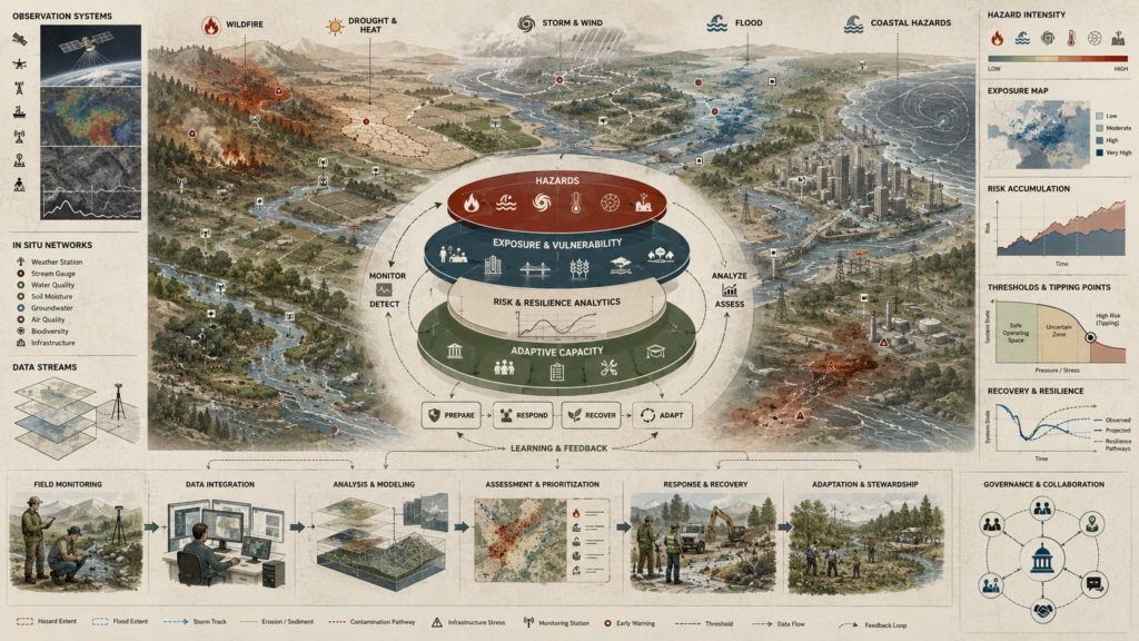
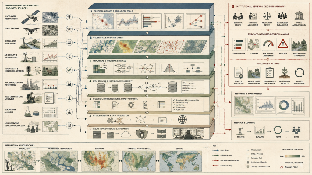
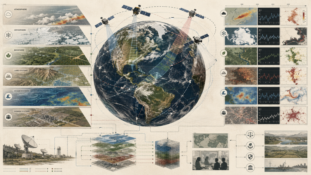
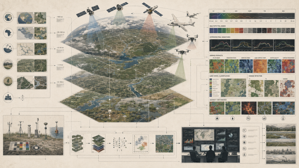
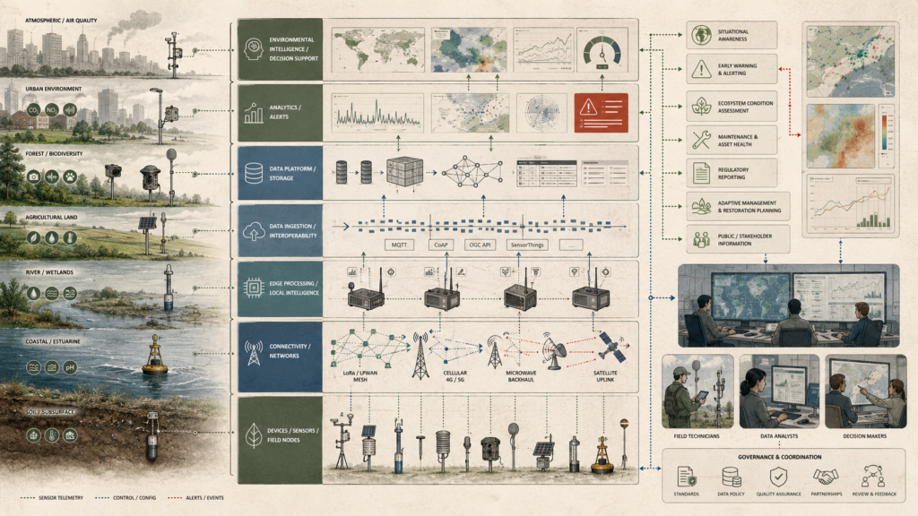
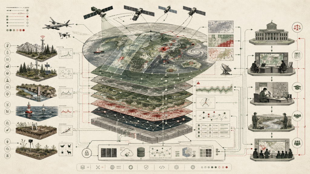
Environmental monitoring systems are becoming integrated intelligence infrastructures that connect Earth observation, field sensing, AI-assisted analysis, interoperable data standards, and public decision-making. The future of monitoring is not only more sensors or higher-resolution imagery; it is the capacity to transform distributed environmental signals into reliable evidence for stewardship, regulation, restoration, disaster preparedness, and long-term ecological governance. Satellites, river gauges, ocean buoys, biodiversity stations, air-quality networks, soil sensors, and edge devices must work within shared metadata, transparent models, reproducible workflows, and accountable institutions. This article examines how environmental intelligence emerges when observation systems, data infrastructure, artificial intelligence, and governance capacity are designed together—turning fragmented measurements into early warnings, ecological baselines, risk thresholds, adaptive management, and public knowledge.

Environmental risk and resilience systems diagram showing hazards, exposure, resilience analytics, adaptive capacity, monitoring networks, recovery pathways, and governance coordination.

Monitoring Environmental Risk and Resilience: Hazards, Recovery, Thresholds, and Adaptive Capacity

Environmental risk and resilience monitoring connects hazard detection, exposure assessment, ecological stress, recovery dynamics, and adaptive capacity into one integrated environmental intelligence system. Hazards such as wildfire, drought, heat, flooding, storms, coastal change, contamination, and biodiversity loss do not affect isolated landscapes; they move through watersheds, infrastructure networks, ecosystems, settlements, and institutions. This article examines how monitoring systems help identify risk accumulation, detect environmental shocks, define thresholds, track recovery, and support adaptive response. Resilience is treated not as a fixed condition, but as a dynamic process shaped by feedback, preparedness, repair, governance capacity, ecological learning, and long-term stewardship. By linking sensors, Earth observation, models, field evidence, recovery indicators, and public decision-making, environmental monitoring becomes a foundation for understanding when systems are under stress, how they recover, and where adaptation is most urgently needed.

Layered disaster early warning systems diagram showing hazard sensing, satellites, monitoring networks, warning chains, communication infrastructure, response timing, and community action.

Disaster Detection and Early Warning Networks: Hazard Sensing, Warning Chains, and Actionable Time

Disaster detection and early warning networks turn environmental signals into actionable time. They connect satellites, radar, buoys, seismic stations, river gauges, wildfire cameras, volcanic sensors, communication infrastructure, emergency operations centers, and public alert systems into a chain that must work before hazards become disasters. This article examines how warning systems detect early signals, interpret uncertainty, define thresholds, issue alerts, and support protective action across floods, storms, wildfires, earthquakes, volcanic activity, landslides, coastal hazards, and heat events. Effective warning is not just a technical problem; it depends on institutions, infrastructure, trust, accessibility, and community readiness. By linking hazard sensing, forecasting, warning dissemination, evacuation planning, shelter coordination, infrastructure protection, and feedback after events, early warning networks convert limited lead time into public safety, resilience, and accountable disaster preparedness.

Layered environmental monitoring and sustainability strategy diagram showing ecosystems, indicators, data infrastructure, feedback loops, governance review, and accountability pathways.

Environmental Monitoring for Sustainability Strategy: Indicators, Feedback, and Environmental Accountability

Environmental monitoring turns sustainability strategy from aspiration into accountable practice. Indicators for ecosystems, emissions, water quality, biodiversity, land use, resource flows, pollution, infrastructure, and community wellbeing only matter when they are connected to feedback, correction, reporting, and institutional responsibility. This article examines how monitoring systems help organizations, municipalities, agencies, and communities translate environmental conditions into measurable evidence, strategic priorities, adaptive management, and public accountability. Sustainability depends not only on collecting data, but on choosing credible indicators, maintaining transparent methods, tracking thresholds, identifying unintended consequences, and responding when conditions deteriorate. By linking field sensors, Earth observation, ecological baselines, data platforms, audit trails, governance checkpoints, and public reporting, environmental monitoring becomes a foundation for learning, correction, restoration, and long-term stewardship.

Environmental analytics dashboard showing monitoring indicators, alerts, maps, sensor inputs, data quality, decision support, governance review, and environmental decision quality.

Environmental Analytics and Monitoring Dashboards: Indicators, Alerts, and Environmental Decision Quality

Environmental analytics and monitoring dashboards shape decision quality by turning environmental data into interpretable evidence, timely alerts, and accountable action. Indicators for water quality, air pollution, biodiversity, hydrology, land condition, emissions, habitat change, and ecosystem stress become more useful when they are organized within dashboards that also show thresholds, anomalies, trends, confidence levels, and geospatial context. This article examines how dashboards support situational awareness, prioritization, early warning, restoration planning, compliance, and adaptive management across environmental systems. A dashboard is not valuable simply because it displays more data; it matters when it improves interpretation, transparency, coordination, and judgment. By linking monitoring networks, analytics, uncertainty, governance review, and response workflows, environmental dashboards become tools for clearer environmental intelligence and better public, institutional, and sustainability decisions.

Layered environmental data platform diagram showing data sources, integration, metadata, analytics, geospatial evidence, decision support, governance review, and environmental action pathways.

Environmental Data Platforms and Decision Support Systems: Integration, Evidence, and Environmental Decision-Making

Environmental data platforms turn fragmented monitoring into evidence for environmental decision-making. Satellites, drones, field sensors, river gauges, air-quality stations, biodiversity observations, laboratory results, industrial monitoring, administrative records, and community data become useful only when they are integrated through interoperable platforms with clear metadata, quality control, versioning, provenance, and audit trails. This article examines how environmental data platforms support decision-support systems by connecting raw observations to geospatial evidence, indicators, analytical models, scenario tools, uncertainty estimates, alerts, reporting workflows, and governance review. Strong platforms do more than store information; they help institutions interpret evidence, prioritize action, assess risk, coordinate response, plan restoration, monitor compliance, and learn from outcomes. By linking data integration, transparency, traceability, and accountability, environmental decision-support systems improve the quality of environmental judgment and public action.

Earth observation systems diagram showing satellites, orbital sensing, atmosphere, cryosphere, biosphere, land, ocean, human systems, data layers, and planetary change evidence.

Satellite Observation and Earth System Monitoring: Orbital Evidence, Coupled Systems, and Planetary Change

Satellite observation makes planetary change visible as evidence. From orbit, satellites monitor atmosphere, cryosphere, biosphere, land systems, oceans, and human activity as coupled Earth systems rather than separate environmental domains. Remote sensing reveals cloud fields, atmospheric plumes, sea ice margins, vegetation change, river networks, wildfire scars, ocean currents, land-use transformation, urbanization, and long-term climate signals across scales that ground monitoring alone cannot capture. This article examines how orbital evidence supports Earth system monitoring through satellites, scanning swaths, geospatial layers, ground stations, data fusion, time-series analysis, anomaly detection, and scientific interpretation. By connecting planetary observation to attribution, accountability, stewardship, and decision-making, satellite monitoring becomes a foundation for understanding environmental change, detecting disturbance, and governing human responsibility within a changing Earth system.

Remote sensing systems diagram showing satellites, aircraft, drones, nested map scales, spectral bands, field validation, change detection, and environmental monitoring workflows.

Remote Sensing Systems in Environmental Monitoring: Scale, Spectral Inference, and Environmental Change

Remote sensing systems expand environmental monitoring by making scale, spectral inference, and environmental change visible together. Satellites, aircraft, drones, and field validation networks observe landscapes from planetary views to regional systems, watersheds, wetlands, farms, forests, cities, and local monitoring plots. This article examines how environmental meaning is inferred from spectral signatures, spatial patterns, false-color imagery, vegetation indices, moisture signals, land-surface temperature, water quality, classification models, and change-detection overlays. Remote sensing is not simply image collection; it is an interpretive system that connects observation footprints, sensor resolution, wavelength bands, calibration, ground truth, uncertainty, and decision support. By linking multiscale monitoring with analytical workflows, remote sensing helps detect disturbance, track ecosystem stress, identify land-use transformation, monitor recovery, and build evidence for environmental stewardship.

Layered environmental IoT architecture diagram showing sensors, field nodes, connectivity networks, edge processing, data platforms, analytics, alerts, and environmental decision support.

IoT Architectures for Environmental Monitoring: Devices, Platforms, and Environmental Intelligence

IoT architectures make environmental monitoring more distributed, continuous, and actionable. Field sensors, weather stations, water-quality probes, soil-moisture devices, camera traps, acoustic sensors, air-quality stations, buoys, and low-power remote nodes collect signals from forests, farms, rivers, wetlands, cities, coastal systems, and subsurface environments. This article examines how these devices become environmental intelligence when they are connected through gateways, mesh networks, LPWAN, cellular links, satellite uplinks, edge processing, interoperable data platforms, analytics, alerts, and decision-support workflows. The value of environmental IoT is not the hardware alone; it is the architecture that links telemetry, device health, data quality, anomaly detection, early warning, ecosystem assessment, regulatory reporting, maintenance, restoration planning, and adaptive management into accountable systems for environmental stewardship.

Scroll to Top