Technology & Systems Intelligence

Technology and systems intelligence examine how advanced analytical tools and digital technologies can enhance our understanding of complex systems. Technologies such as artificial intelligence, machine learning, sensor networks, and large-scale data analytics are increasingly used to analyze environmental, economic, and social systems.

Systems intelligence emphasizes the ability to integrate data, models, and human expertise in order to interpret complex patterns and support informed decision-making. Rather than replacing human judgment, these technologies augment the capacity of researchers and institutions to detect trends, simulate outcomes, and evaluate policy interventions.

As digital technologies become more deeply integrated into governance and sustainability research, the challenge lies in deploying them responsibly. Effective systems intelligence requires transparency, accountability, and careful integration with ethical and institutional frameworks.

Restrained infrastructure security diagram showing power, water, transport, communications, industrial systems, OT networks, segmentation, risk pathways, continuity planning, response, and recovery workflows.

Infrastructure Security and Cyber Resilience: OT Protection, Continuity and Recovery

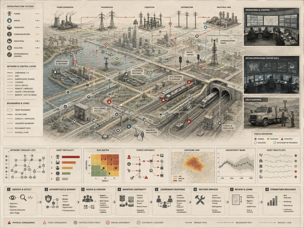
Infrastructure security and cyber resilience protect essential services by linking operational technology, continuity planning, and recovery into one public-safety framework. Power systems, water treatment, wastewater facilities, transportation corridors, rail signaling, communications towers, industrial sites, control cabinets, sensors, and field devices increasingly depend on connected networks that must remain reliable under disruption. This article examines how OT protection depends on segmentation, monitoring, access control, asset criticality, threat-pathway analysis, exposure mapping, uncertainty assessment, incident response, and service restoration. Cyber resilience is not only about preventing intrusion; it is about maintaining safe operations, isolating affected systems, coordinating field response, preserving backup pathways, and restoring public services responsibly. By connecting cybersecurity, infrastructure continuity, operational recovery, and governance accountability, resilient infrastructure security helps protect communities from cascading failure.

Restrained infrastructure governance diagram showing regional infrastructure systems, planning stages, public agencies, evidence layers, oversight pathways, accountability checkpoints, and public-value outcomes.

Infrastructure Governance and Policy Systems: Planning, Delivery and Public Accountability

Infrastructure governance and policy systems determine whether public infrastructure is planned, delivered, maintained, and reviewed in ways that serve long-term public value. Bridges, roads, rail corridors, water systems, stormwater networks, power infrastructure, communications systems, housing districts, public facilities, parks, reservoirs, and ecological buffers require more than engineering capacity; they require institutions, funding, oversight, participation, and accountability. This article examines how needs assessment, policy alignment, capital planning, procurement, environmental review, project delivery, operations, maintenance, performance monitoring, public reporting, and grievance review shape infrastructure outcomes. Good governance links evidence to decisions, decisions to delivery, and delivery to measurable service quality. By connecting planning, transparency, fiscal responsibility, resilience, equity, and intergenerational stewardship, infrastructure policy systems help protect public trust and accountable infrastructure futures.

Climate adaptation infrastructure diagram showing coastal flooding, extreme heat, wildfire, drought, stormwater systems, transport networks, water systems, resilience projects, and implementation pathways.

Infrastructure Systems for Climate Adaptation: Risk, Resilient Development and Implementation

Infrastructure systems for climate adaptation connect risk assessment to resilient development and implementation. Extreme rainfall, coastal surge, river flooding, drought, heat, wildfire, erosion, landslide risk, and infrastructure strain affect transportation, water, energy, housing, ecosystems, and public services as interdependent systems. This article examines how adaptation depends on exposure mapping, criticality analysis, scenario comparison, project prioritization, resilient design, delivery capacity, monitoring, maintenance, and service continuity. Adaptation is not only a planning exercise; it requires institutions that can fund, build, operate, evaluate, and revise infrastructure under changing climate conditions. By linking risk evidence, green and gray infrastructure, public accountability, equity, and long-term stewardship, climate adaptation systems help communities reduce harm, protect essential services, and invest in resilient futures.

Flood and disaster early warning infrastructure diagram showing radar, rain gauges, river gauges, telemetry, forecasting, warning beacons, emergency coordination, evacuation routes, and protective action systems.

Flood and Disaster Early Warning Infrastructure: Detection, Communication and Protective Action

Flood and disaster early warning infrastructure turns hazard detection into protective action. Radar, rain gauges, stream gauges, river gauges, reservoir sensors, coastal buoys, telemetry gateways, forecasting systems, warning beacons, emergency operations centers, agency coordination, and field response teams must work as one chain before flooding or disaster impacts occur. This article examines how early warning systems connect rainfall estimates, river forecasts, inundation mapping, uncertainty assessment, thresholds, alerts, evacuation routes, shelters, road closures, critical facilities, and continuity planning. Effective warning is not only a technical sensing problem; it depends on trusted communication, institutional coordination, accessible alerts, and timely public action. By linking detection, forecasting, communication, mobilization, and protective decisions, early warning infrastructure helps reduce harm and strengthen community resilience.

Restrained climate monitoring infrastructure diagram showing satellites, glacier stations, flux towers, ocean buoys, river gauges, coastal sensors, climate baselines, trend records, and long-term risk interpretation.

Climate Monitoring Infrastructure: Baselines, Observation and Long-Term Climate Risk

Climate monitoring infrastructure makes long-term climate risk visible through baselines, durable observation, and trusted environmental records. Satellites, glacier stations, flux towers, river gauges, tide gauges, ocean buoys, atmospheric sensors, soil monitors, biodiversity observations, and land-use monitoring systems measure change across atmosphere, land, ocean, cryosphere, ecosystems, and human settlements. This article examines how climate evidence becomes meaningful through telemetry, harmonization, quality control, climate data records, baseline comparison, trend detection, attribution, reporting, archival stewardship, and decision support. Long-term risk cannot be understood through isolated measurements alone; it requires consistent observation systems that reveal shifts in temperature, precipitation, sea level, snow cover, soil moisture, ocean conditions, carbon flux, burned area, and biodiversity.

Restrained environmental monitoring infrastructure diagram showing watershed sensors, satellites, drones, telemetry, risk layers, water systems, air quality, soil monitoring, stewardship review, and management action.

Infrastructure for Environmental Monitoring Systems: Observation, Risk and Stewardship

Environmental monitoring infrastructure connects observation, risk interpretation, and stewardship across watersheds, ecosystems, and built systems. Weather stations, hydrologic gauges, groundwater wells, water-quality probes, air-quality monitors, soil-moisture sensors, acoustic and camera systems, telemetry masts, edge gateways, buoys, satellites, and drones help make environmental conditions visible across mountains, rivers, wetlands, farms, settlements, infrastructure, and coastal waters. This article examines how monitoring infrastructure supports data integration, quality control, risk assessment, indicator tracking, anomaly detection, public reporting, stewardship review, and management action. Its value is not measurement alone; it is the ability to connect environmental evidence to watershed protection, restoration planning, resilience priorities, maintenance decisions, and accountable governance. By linking observation networks to public responsibility, environmental monitoring infrastructure supports long-term ecological stewardship.

Restrained urban resilience infrastructure diagram showing flood barriers, pump stations, resilient transit, backup power, green infrastructure, hazard exposure, service continuity, and adaptation pathways.

Infrastructure Systems for Urban Resilience: Risk, Adaptation and Service Continuity

Urban resilience infrastructure protects essential services by connecting risk assessment, adaptation, and continuity planning across interdependent city systems. Transportation networks, water and stormwater systems, energy grids, communications nodes, emergency hubs, green infrastructure, flood barriers, pump stations, detention basins, cooling corridors, microgrids, and public facilities must function under pressure from extreme rainfall, coastal surge, heat, drought, wildfire smoke, and infrastructure strain. This article examines how urban resilience depends on hazard exposure mapping, network criticality, service-continuity planning, adaptation pathways, operations coordination, maintenance, emergency response, and long-term investment. Resilience is not only about hardening individual assets; it is about keeping communities connected, protected, and served when systems are stressed. By linking infrastructure planning to public stewardship, cities can reduce risk, adapt to changing conditions, and safeguard essential services.

Restrained urban sensor network diagram showing bridges, rail, roads, stormwater systems, utilities, telemetry links, risk overlays, asset condition, service continuity, and operations review.

Urban Sensor Networks and Infrastructure Monitoring: Observability, Risk and Resilience

Urban sensor networks make infrastructure conditions observable across complex city systems. Traffic sensors, bridge monitors, water-level gauges, pipe sensors, air-quality nodes, weather stations, acoustic monitors, smart meters, flood sensors, utility monitors, edge gateways, and telemetry masts help reveal how roads, rail lines, tunnels, stormwater systems, water networks, substations, wastewater facilities, public buildings, and neighborhoods are performing in real time. This article examines how distributed sensing supports risk detection, asset condition monitoring, service continuity, maintenance prioritization, and resilience planning. Urban observability is valuable only when data quality, interpretation, operations review, public reporting, and management action are connected. By linking sensor networks to accountable infrastructure decisions, cities can detect disruption earlier, maintain essential services, reduce risk, and strengthen resilience across interconnected urban systems.

Restrained intelligent transportation network diagram showing roads, rail, buses, freight, traffic sensors, telemetry, congestion maps, operations centers, public information, and adaptive response pathways.

Intelligent Transportation Networks: Mobility, Data and Network Coordination

Intelligent transportation networks turn mobility data into coordinated public infrastructure. Roads, bridges, intersections, tunnels, rail lines, buses, freight corridors, bicycle networks, pedestrian systems, stations, and parking assets increasingly depend on sensors, telemetry, signal systems, operations centers, and public information channels. This article examines how transportation intelligence connects traffic detection, travel-time reliability, transit performance, freight movement, incidents, road weather, asset health, congestion, service continuity, and adaptive response. Intelligent transportation is not only about optimizing traffic flow; it is about improving safety, reliability, mobility choice, equity, resilience, sustainability, and public value. By linking data, infrastructure, operations, and governance, transportation networks can coordinate movement more effectively while supporting accountable, accessible, and resilient urban mobility.

Scroll to Top