
Last Updated May 7, 2026
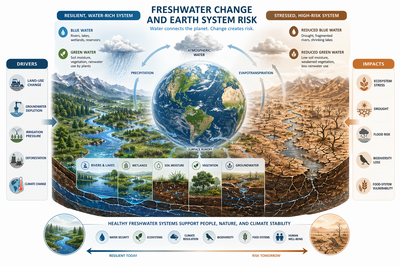
Freshwater change is one of the most important developments in the planetary boundaries framework because it broadened the earlier focus on freshwater use into a deeper Earth-system understanding of hydrological disruption. In the original framework, the concern centered mainly on consumptive use of blue water such as rivers, lakes, reservoirs, wetlands, and groundwater. That was an important starting point, but it proved too narrow. Human societies are not only withdrawing visible water from streams, reservoirs, and aquifers. They are also altering the wider water cycle through land conversion, vegetation loss, damming, irrigation, drainage, groundwater depletion, soil degradation, wetland loss, atmospheric warming, and climate-driven changes in precipitation and evaporation. The result is not simply localized scarcity. It is a disturbance of the hydrological conditions that help regulate ecosystems, agriculture, climate, biodiversity, nutrient cycling, and planetary resilience.
This broader framing matters because freshwater is not merely a resource to be allocated among households, farms, cities, industries, and ecosystems. It is one of the circulatory processes through which the Earth system maintains stability. Water moves through soils, plants, rivers, aquifers, wetlands, clouds, glaciers, atmospheric flows, and oceans in patterns that support productivity, biodiversity, cooling, carbon exchange, nutrient transport, habitat continuity, and ecological resilience. Once those patterns are sufficiently altered, the effects radiate outward. Forests lose resilience, food systems become more volatile, ecosystems fragment, nutrient pollution intensifies, drought and flood regimes shift, groundwater buffers weaken, and land-atmosphere feedbacks become more unstable. Freshwater change is therefore not just a development issue, a utility issue, or a local scarcity issue. It is a planetary-risk issue.
Main Library
Publications
Article Map
Planetary Boundaries
Related Article
Land-System Change
Related Article
Biosphere Integrity
Related Topic
Environmental Monitoring
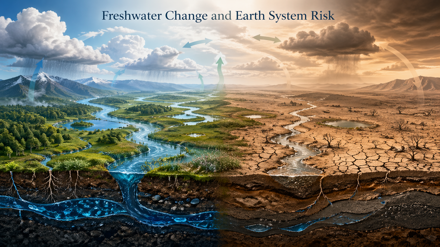
The updated planetary-boundaries literature recognizes this by distinguishing between blue water and green water. Blue water refers to rivers, lakes, wetlands, reservoirs, and groundwater systems. Green water refers to soil moisture and plant-available water, especially root-zone moisture that sustains terrestrial ecosystems, agriculture, evapotranspiration, and rainfall recycling. This distinction is decisive because the Earth system does not depend only on the water people can pump, divert, store, meter, or sell. It also depends on the water embedded in soils, vegetation, and ecological processes. A basin can appear operationally managed while root-zone moisture collapses, vegetation loses resilience, or land-atmosphere coupling weakens. Freshwater change therefore names a deeper hydrological transformation than freshwater withdrawal alone.
This article examines freshwater change as a planetary boundary by explaining why the boundary was reconceived, how blue water and green water function within the Earth system, why freshwater disruption must be understood as systemic risk rather than only water scarcity, how the boundary interacts with climate change, land-system change, biosphere integrity, biogeochemical flows, food systems, environmental monitoring, infrastructure, justice, and governance, and why freshwater change has become central to sustainability science and long-term civilizational resilience.
Why Freshwater Change Matters
Freshwater change matters because water is not simply a stock that societies draw down for domestic, industrial, agricultural, or energy use. It is a dynamic cycle that connects atmosphere, land, vegetation, soils, rivers, aquifers, wetlands, cryosphere, and oceans. Through that circulation, freshwater helps regulate ecosystem function, crop growth, carbon exchange, temperature, habitat structure, nutrient movement, and the broader resilience of the biosphere. When hydrological conditions are significantly altered, the consequences do not remain confined to water supply. They propagate through ecological and climatic systems in ways that can accumulate into wider instability.
This is one reason the freshwater boundary became conceptually stronger over time. Earlier debates often treated water as a problem of scarcity, infrastructure, irrigation, urban supply, or allocation. Those concerns remain real, but they do not exhaust the meaning of freshwater in the planetary boundaries framework. The deeper question is whether human societies are disturbing the hydrological processes that helped sustain relatively stable Holocene conditions. Once posed in those terms, freshwater becomes part of Earth-system regulation rather than a narrowly managed utility.
That shift in perspective also changes the moral and strategic meaning of water governance. It is no longer enough to ask whether societies can secure enough supply for immediate needs. The larger issue is whether they are preserving the hydrological conditions under which ecosystems, agriculture, climate resilience, public health, and social stability remain possible over long time horizons. Freshwater change therefore belongs to the same class of problems as climate destabilization and biosphere degradation: it concerns the background conditions of organized human life.
The freshwater boundary also matters because water systems often fail unevenly before they fail globally. Groundwater depletion may be hidden. Soil-moisture decline may be normalized. River fragmentation may be framed as infrastructure progress. Wetland loss may be treated as local land conversion. But when these changes accumulate across basins, landscapes, and climate zones, they reveal a deeper transformation of the Earth’s water cycle. Freshwater change is therefore a boundary about visible scarcity and invisible reorganization at the same time.
Freshwater also matters because it mediates the relationship between land and atmosphere. Water stored in soils and vegetation shapes evapotranspiration, cooling, cloud formation, and rainfall recycling. Water moving through rivers and groundwater sustains wetlands, aquatic ecosystems, floodplains, farms, cities, and industrial systems. Snow and glaciers regulate seasonal flow in many regions. When these systems are disrupted together, societies do not merely face “less water.” They face unstable timing, altered extremes, degraded ecological buffers, and reduced resilience.
This is why freshwater change is a planetary-boundary issue. It is not only about whether water can be delivered through pipes. It is about whether the Earth system retains the hydrological patterns that make ecosystems, food systems, settlements, and adaptation possible.
From Freshwater Use to Freshwater Change
In the original 2009 planetary boundaries framework, the freshwater boundary was framed mainly in terms of consumptive freshwater use. The emphasis fell on blue water: the visible freshwater withdrawn from rivers, lakes, reservoirs, wetlands, and groundwater systems. This was a major intellectual advance because it introduced water into a planetary-risk architecture rather than leaving it within ordinary resource policy. Yet the original framing still carried the limitations of a use-based perspective. It focused more on what humans were taking out of the system than on how they were changing the system itself.
Over time, that limitation became harder to ignore. Hydrological disruption does not occur only through extraction. It also occurs when forests are cleared, wetlands are drained, soils are degraded, groundwater is mined faster than recharge, rivers are fragmented, irrigation reorganizes regional moisture flows, dams change seasonal timing, drainage accelerates runoff, and warming intensifies evaporation and shifts precipitation patterns. In other words, freshwater instability may arise even when the central problem is not direct withdrawal alone. What matters is whether the movement, storage, timing, and ecological availability of water are being altered at scales large enough to destabilize the Earth system.
The revised framing of the boundary as freshwater change reflects this wider understanding. It captures not only consumptive blue-water use but also deviations in streamflow and root-zone soil moisture from preindustrial or Holocene-like baseline conditions. That change is conceptually important because it recognizes that humanity is reshaping the hydrological cycle itself. The boundary is therefore no longer simply about how much freshwater is used. It is about how deeply the water cycle has been reorganized.
This shift also makes the freshwater boundary more useful for engineers, planners, hydrologists, environmental managers, and systems modelers. A use-based metric can identify extraction pressure, but a change-based framework can diagnose hydrological deviation, ecological exposure, seasonal instability, soil-moisture anomalies, watershed connectivity, and resilience loss. It moves water analysis from accounting alone toward system diagnosis.
The shift from use to change also protects against false reassurance. A region may reduce withdrawals while still experiencing collapsing soil moisture, degraded wetlands, altered streamflow timing, groundwater decline, or rising flood volatility. Conversely, a water system may appear adequate by annual average supply while becoming more unstable seasonally. Freshwater change forces analysis to ask whether the cycle remains within a resilient operating range, not merely whether a water budget balances on paper.
| Framing | Primary concern | Limitation | Planetary-boundary upgrade |
|---|---|---|---|
| Freshwater use | Consumptive withdrawals from rivers, lakes, reservoirs, wetlands, and groundwater. | Can miss soil moisture, flow timing, ecological water needs, and hydrological reorganization. | Useful starting point, but incomplete for Earth-system diagnosis. |
| Blue-water pressure | Visible freshwater stores and flows used by people and ecosystems. | Requires attention to flow regimes, groundwater, water quality, environmental flows, and seasonality. | Tracks streamflow deviation, groundwater depletion, and ecological flow integrity. |
| Green-water pressure | Root-zone soil moisture and plant-available water. | Often invisible in conventional water allocation systems. | Connects water to vegetation, food systems, rainfall recycling, and land-atmosphere feedbacks. |
| Freshwater change | Human-driven alteration of the water cycle itself. | Requires integrated monitoring across land, climate, ecosystems, and infrastructure. | Frames water as an Earth-system process, not only a resource stock. |
The conceptual upgrade is therefore not merely semantic. It changes what must be measured, what must be governed, and what counts as risk. Freshwater change asks whether the hydrological architecture of the Earth system remains stable enough to support life, agriculture, ecosystems, and social resilience.
Blue Water and Green Water
A central innovation in the updated freshwater boundary is the distinction between blue water and green water. Blue water refers to visible freshwater in rivers, lakes, reservoirs, wetlands, and groundwater bodies. It is the part of the hydrological system most familiar to conventional water management because it is measurable, extractable, stored, diverted, allocated, and governed through infrastructure. Blue water is the domain of dams, wells, pipelines, irrigation canals, municipal systems, environmental flows, hydropower operations, and water rights.
Green water, by contrast, refers to water stored in soils and vegetation, especially the root-zone moisture available to plants. It is less visible but no less important. Green water sustains forests, croplands, grasslands, savannas, wetlands, and other terrestrial ecosystems. It influences evapotranspiration, plant productivity, habitat resilience, rainfall recycling, surface energy balance, carbon exchange, and land-atmosphere coupling. In many respects, green water links hydrology directly to biosphere integrity, land-system stability, and climate regulation.
This distinction matters because a water framework centered only on blue water can miss major forms of Earth-system disruption. A basin might maintain apparent streamflow while soils dry out, vegetation weakens, evapotranspiration shifts, and ecosystems lose resilience. Likewise, agricultural systems may appear productive while depending on patterns of green-water depletion that are ecologically unsustainable. The expanded freshwater boundary corrects this distortion by recognizing that visible water and ecological water are both essential to planetary stability.
Green water is especially important for understanding why water is not only a river-basin problem. Soil moisture and vegetation influence atmospheric moisture recycling across regions. Forests and other ecosystems can help return water vapor to the atmosphere, affecting rainfall patterns beyond the place where the water was first stored. When land cover and soil moisture change at scale, the hydrological consequences can extend across landscapes and climate systems. The freshwater boundary therefore links water management to land stewardship.
The blue-water / green-water distinction also helps bridge engineering and ecology. Blue-water systems are often treated through infrastructure, law, allocation, and hydraulic control. Green-water systems are treated through soil health, land cover, vegetation, agroecology, watershed restoration, and climate adaptation. A serious freshwater-change strategy must join these worlds. Irrigation efficiency matters, but so does soil organic matter. Reservoir operations matter, but so do wetlands. Groundwater caps matter, but so does rainfall recycling through vegetation.
| Water domain | Core examples | Earth-system role | Governance implication |
|---|---|---|---|
| Blue water | Rivers, lakes, wetlands, reservoirs, aquifers, streamflow, groundwater. | Supports aquatic ecosystems, water supply, environmental flows, floodplain function, recharge, and drought buffering. | Requires flow protection, groundwater governance, water-quality controls, environmental flows, and basin-scale management. |
| Green water | Root-zone soil moisture, plant-available water, vegetation-water interactions. | Supports plant growth, evapotranspiration, cooling, carbon exchange, rainfall recycling, and terrestrial ecosystem resilience. | Requires soil restoration, vegetation stewardship, agroecology, wetland protection, forest conservation, and land-use planning. |
| Atmospheric water | Evaporation, transpiration, clouds, precipitation, vapor flows. | Links land, vegetation, climate, and rainfall patterns across regions. | Requires climate mitigation and land-system governance, not only local water management. |
| Frozen water | Snowpack, glaciers, seasonal ice, mountain cryosphere systems. | Regulates seasonal flows, river timing, downstream water security, and hazard exposure. | Requires climate adaptation, cryosphere monitoring, basin planning, and long-term risk assessment. |
The expanded boundary therefore recognizes water as a coupled system: blue, green, atmospheric, and frozen water interact. Conventional management often separates them. Earth-system stability depends on their connection.
Why Water Is an Earth-System Process
Water is an Earth-system process because it connects atmosphere, land, ecosystems, cryosphere, and biogeochemistry through continuous and dynamic circulation. Soil moisture shapes vegetation, and vegetation shapes evapotranspiration, cloud formation, local cooling, and rainfall recycling. Rivers and groundwater influence wetlands, aquatic ecosystems, nutrient flows, sediment transport, and the availability of water for agriculture and settlements. Snowpack and glaciers regulate seasonal flows, while oceans, atmospheric circulation, and terrestrial moisture feedbacks help determine patterns of drought, storm intensity, monsoons, and long-range hydrological variability.
Seen this way, water cannot be reduced to the volume stored behind dams or pumped from aquifers. It is one of the Earth system’s circulatory processes. It moves material and energy, helps distribute heat, connects ecological zones, sustains the productivity of terrestrial and aquatic systems, and mediates the relationship between climate and life. Disturbing that circulation at scale can therefore affect much more than supply. It can alter the operating conditions of the biosphere and destabilize the interactions among land, climate, and living systems.
This is why freshwater change now sits more tightly alongside climate change, land-system change, and biosphere integrity in the planetary boundaries framework. Hydrological disruption is not downstream of those issues in a narrow sense. It is mutually constitutive of them. Water is one of the media through which planetary instability is expressed and amplified.
The Earth-system role of water also explains why freshwater governance cannot be left only to infrastructure agencies or market allocation mechanisms. Infrastructure can store, move, treat, and distribute water, but it cannot replace the ecological functions of soil moisture, wetlands, riparian zones, aquifers, forests, and functioning watersheds. Freshwater change therefore requires a systems view that combines engineering, ecology, hydrology, agriculture, climate science, and governance.
Water’s Earth-system role also makes simple efficiency narratives incomplete. Efficiency can reduce waste, but efficiency can also increase total extraction if saved water is used to expand irrigated area, intensify production, or support new demand. A hydrological system can become more technically optimized while becoming less resilient. The planetary-boundary perspective therefore asks not only whether water is used efficiently, but whether water cycles remain within ecological limits.
Water is also an information system. Streamflow, snowpack, groundwater levels, soil moisture, vegetation stress, flood frequency, drought persistence, and wetland condition all signal changes in the Earth system. Monitoring freshwater change is therefore not only a utility task. It is part of planetary diagnosis.
The Boundary and Its Current Status
The updated freshwater boundary is transgressed. Current assessments of the planetary boundaries framework conclude that both blue-water and green-water components have moved beyond safe levels. This is a serious finding because it indicates that hydrological disruption is not a future threat awaiting confirmation. It is an already existing condition of Earth-system instability.
The significance of this status lies partly in timing. Recent work highlighted by Stockholm Resilience Centre reports that the updated freshwater-change boundary was crossed by the mid-twentieth century, suggesting that large-scale hydrological deviation has been building for decades. That historical depth matters because it shows that freshwater destabilization is not a sudden anomaly produced by a single recent event. It is the cumulative outcome of long-term land conversion, industrial agriculture, river regulation, groundwater depletion, ecological degradation, and climate change.
It also matters because the freshwater boundary is not breached in only one way. Some regions experience chronic drying, falling groundwater levels, snowpack decline, declining soil moisture, and reduced ecological water availability. Others experience altered flood regimes, river-flow extremes, wetland loss, groundwater stress, or intensified hydrological variability. What unites these manifestations is that they represent a widening departure from the hydrological patterns within which ecosystems and societies previously developed.
The boundary’s current status should therefore be interpreted as a systems warning rather than a claim that every basin is equally dry or equally water-stressed. Freshwater change is not uniform. It is spatially heterogeneous, seasonally variable, and connected to land, climate, and ecological context. The global boundary is breached because the pattern of human-induced hydrological deviation has become large enough to matter for Earth-system stability.
The status also has governance implications. A breached boundary does not mean recovery is impossible. It means the system has moved outside the safer operating range and that the margin for delay is narrowing. Freshwater governance must therefore shift from reactive crisis management to anticipatory hydrological resilience: protecting flows, soils, aquifers, wetlands, vegetation, and environmental buffers before the loss of water-system function becomes harder to reverse.
| Freshwater component | Boundary interpretation | Why it matters |
|---|---|---|
| Blue water | Streamflow and surface-groundwater systems have deviated beyond safer operating conditions. | Signals pressure on rivers, lakes, wetlands, groundwater, aquatic ecosystems, and flow regimes. |
| Green water | Root-zone soil moisture has moved beyond Holocene-like variability across large areas. | Signals pressure on vegetation, agriculture, rainfall recycling, carbon exchange, and land-atmosphere coupling. |
| Historical timing | Recent research indicates transgression around the mid-twentieth century. | Shows that freshwater change is cumulative and long-running, not merely a recent drought-cycle concern. |
| Current status | Freshwater change is breached in current planetary-boundary assessments. | Requires integrated governance across water, land, climate, food, and ecosystem systems. |
The freshwater boundary should therefore be read as a warning about hydrological resilience. Water systems are changing in ways that exceed ordinary management categories. The task is not only to allocate water more efficiently, but to restore the ecological and climatic processes that keep water systems stable.
Blue Water Pressure: Rivers, Groundwater, and Flow Regimes
Blue water pressure concerns rivers, lakes, wetlands, reservoirs, and groundwater. It includes direct withdrawals for irrigation, households, industry, mining, energy systems, and cities, but it also includes alterations to the timing and variability of flows. A river can be heavily altered even if annual volume appears adequate, because ecological systems depend on seasonal pulses, low flows, floodplain connectivity, sediment movement, temperature regimes, and migration pathways. Flow timing is part of the hydrological system, not an incidental detail.
Groundwater is especially important because it often functions as a hidden buffer. Aquifers can support irrigation, urban supply, wetlands, baseflow in rivers, and drought resilience. But groundwater depletion can accumulate quietly for years before the full consequences become visible. Falling water tables can increase pumping costs, reduce river baseflows, dry wetlands, intensify land subsidence, and weaken resilience during drought. Once deep aquifers are depleted, recovery can be slow, uncertain, or effectively impossible on human time scales.
Blue water pressure therefore cannot be measured adequately by annual withdrawal alone. The relevant questions include where water is withdrawn, when it is withdrawn, how much is returned, what quality it has when returned, whether environmental flows are maintained, whether groundwater recharge is sufficient, whether rivers remain connected, and whether aquatic ecosystems retain the hydrological variation they need to function.
This is why environmental-flow requirements are central to freshwater governance. A river is not merely a pipe. It is an ecological and geomorphological system. Protecting blue water means protecting the flow regimes that make rivers, wetlands, floodplains, aquifers, and aquatic habitats resilient.
Blue-water pressure is also affected by infrastructure. Dams, diversions, levees, canals, pumps, channelization, stormwater systems, and hydropower operations can transform flow regimes. Some infrastructure is necessary and can be designed responsibly, but infrastructure that suppresses all variability can harm the ecological dynamics that rivers require. Flood pulses, sediment transport, wetland recharge, fish migration, riparian regeneration, and groundwater-surface water exchange are not inefficiencies. They are part of river-system life.
Water quality also belongs within blue-water pressure. A river with adequate volume but high nutrient loads, toxic contamination, saline intrusion, thermal pollution, or low dissolved oxygen may fail ecologically. Quantity and quality cannot be separated. Freshwater change is therefore a combined problem of flow, storage, timing, connectivity, temperature, chemistry, and ecological function.
Green Water Pressure: Soil Moisture, Vegetation, and Rainfall Recycling
Green water pressure concerns the water stored in soils and used by plants. It is one of the most important additions to the freshwater boundary because it captures hydrological change that conventional water accounting often overlooks. Soil moisture determines whether vegetation can grow, whether crops can survive drought, whether forests can resist heat stress, whether fire risk increases, and whether landscapes can continue cycling water back to the atmosphere through evapotranspiration.
Green water is also central to rainfall recycling. Vegetation does not merely consume water. It participates in atmospheric moisture flows. Forests, wetlands, grasslands, and other ecosystems return water vapor to the atmosphere, influence cloud formation, and help regulate regional moisture dynamics. When vegetation is removed or soil moisture declines, landscapes can become hotter, drier, and less able to generate or sustain rainfall feedbacks. This means green-water disruption can reinforce drying in ways that exceed the immediate site of disturbance.
The green-water boundary is also closely linked to agriculture. Rainfed farming depends heavily on soil moisture, and even irrigated systems ultimately depend on climate, soil structure, and groundwater or surface-water availability. Soil degradation, compaction, erosion, organic-matter loss, and monocropping can reduce the capacity of soils to absorb and retain water. A food system that treats soil primarily as a substrate for inputs may miss the fact that soil is also a water-storage and climate-regulation system.
Green-water governance therefore requires land stewardship. Cover crops, agroforestry, perennial systems, soil organic matter, wetland protection, forest conservation, restoration ecology, reduced compaction, careful grazing, and watershed-scale vegetation management all become freshwater strategies. They are not merely land practices. They are hydrological practices.
This is especially important under climate change. Higher temperatures increase evaporative demand, meaning soils and vegetation can dry more quickly even when rainfall does not decline dramatically. Longer dry spells, heat waves, and altered precipitation timing can weaken green-water resilience. A region may still receive enough annual rainfall on paper while experiencing soil-moisture stress at the wrong time for crops, forests, or ecosystems. Green-water monitoring therefore needs seasonal and ecological resolution, not only annual averages.
Green water also challenges the boundary between “natural” and “managed” systems. Cropland, forests, urban green space, wetlands, rangelands, and restoration sites all participate in soil-water dynamics. Every land-management decision is also a water decision. The updated freshwater boundary makes that relationship explicit.
Freshwater Change and Food Systems
Freshwater change is inseparable from food systems. Agriculture is the largest human use of freshwater in many regions, and crop production depends on both blue water and green water. Irrigated agriculture draws heavily on rivers, reservoirs, and aquifers. Rainfed agriculture depends on soil moisture, precipitation reliability, and vegetation-soil interactions. Livestock systems depend on feed, drinking water, pasture conditions, and the wider hydrological systems that support them. When freshwater systems become unstable, food systems become unstable as well.
This relationship is not only about scarcity. It is also about timing, volatility, and resilience. A region may receive the same annual rainfall but experience more intense storms, longer dry spells, reduced infiltration, and greater runoff. That can undermine crop reliability even if total precipitation does not collapse. Similarly, irrigation can sustain production temporarily while depleting groundwater buffers that future production depends on. Freshwater change therefore creates food-system risk by destabilizing the hydrological assumptions built into farming, trade, storage, and infrastructure.
The food-system dimension also makes the freshwater boundary ethically complex. Some regions need improved water access, irrigation, storage, and soil-moisture management to support food security. Other regions need reductions in over-extraction, inefficient irrigation, crop choices poorly matched to hydrological limits, and nutrient runoff. A planetary-boundary response cannot be reduced to universal restriction. It must distinguish between water access, water waste, ecological flow protection, soil-water restoration, and justice.
Freshwater resilience in food systems therefore requires both technical and ecological strategies: efficient irrigation, crop diversification, drought-resilient farming, soil restoration, rainwater harvesting, groundwater governance, watershed protection, reduced food loss, and shifts away from production systems that externalize water risk downstream or into future generations.
Food systems also connect freshwater change to biogeochemical flows. Fertilizer runoff, manure concentration, wastewater, erosion, and drainage can move nitrogen and phosphorus into rivers, lakes, wetlands, and coastal systems. Hydrological alteration changes how nutrients travel, accumulate, and trigger eutrophication. In this sense, water is the transport system through which many nutrient problems become ecological crises.
Freshwater also shapes food-system inequality. Farmers with capital may drill deeper wells, buy pumps, install irrigation, or shift production. Smallholders, pastoralists, rainfed farmers, fishers, and low-income households may have fewer buffers. When hydrological conditions become less reliable, those with the least responsibility for destabilization can be exposed first. A just food-water strategy must therefore protect basic needs, ecological flows, and vulnerable livelihoods while reducing high-pressure forms of extraction and waste.
Groundwater Depletion and Hidden Risk
Groundwater depletion is one of the clearest examples of hidden freshwater risk. Because aquifers are out of sight, depletion can proceed for years while societies experience the illusion of stability. Wells continue to pump. Crops continue to grow. Cities continue to expand. But the underlying buffer is being consumed. When groundwater levels fall far enough, the consequences can be sudden, expensive, and difficult to reverse.
The danger is not only that less groundwater is available. Groundwater depletion can reduce river baseflow, dry wetlands, damage ecosystems, increase pumping energy, concentrate contaminants, cause land subsidence, and reduce resilience during drought. In coastal regions, over-pumping can contribute to saltwater intrusion. In agricultural regions, it can create a dependency trap in which production depends on withdrawals that cannot be sustained.
Groundwater also illustrates why freshwater governance must operate over long time scales. Some aquifers recharge slowly. Some contain fossil water accumulated under past climate conditions. Some groundwater systems are connected to surface ecosystems in ways that are poorly understood until decline becomes visible. A short-term accounting system may count groundwater extraction as water supply, while a systems perspective recognizes it as the liquidation of hydrological capital.
Within the planetary-boundary framework, groundwater depletion matters because it weakens the resilience of blue-water systems and can intensify green-water stress by sustaining land-use patterns that exceed long-term hydrological conditions. It is therefore both a resource problem and a resilience problem.
Groundwater governance is difficult because depletion often benefits present users while imposing costs on future users, downstream ecosystems, and communities without access to deeper wells. It also crosses property and jurisdictional boundaries. One landowner’s pumping can affect another user’s well, a nearby stream, or a wetland. These dynamics make groundwater a classic case of hidden cumulative risk.
Monitoring is essential but not sufficient. Groundwater systems require caps, recharge protection, land-use alignment, crop choices suited to hydrological realities, demand reduction where necessary, and protection of groundwater-dependent ecosystems. A water system that depends on mining aquifers faster than recharge is borrowing stability from the future.
Freshwater Justice and Unequal Risk
Freshwater change is also a justice issue. The harms of water-cycle disruption are not distributed evenly. Low-income communities, Indigenous peoples, smallholder farmers, pastoralists, informal settlements, downstream communities, women and girls responsible for water collection in some contexts, groundwater-dependent households, and communities exposed to flood or drought often experience hydrological stress before powerful users do. Meanwhile, the benefits of over-extraction, pollution, damming, land conversion, and industrial water use may be captured by distant consumers, firms, investors, or urban growth systems.
Water injustice is not only about scarcity. It is about control, contamination, infrastructure, rights, timing, exposure, and voice. A community may live near water that is unsafe to drink. A river may be diverted away from ecosystems and downstream users. Groundwater may be depleted by high-capacity wells that smaller users cannot match. Wetlands may be drained for development, leaving flood risk to poorer neighborhoods. Urban infrastructure may protect wealthier districts while exposing informal settlements to sewage, stormwater, or flood hazards.
Freshwater justice must therefore include both access and ecological integrity. Safe drinking water, sanitation, public health, and basic water security are human necessities. But water access cannot be secured over the long run by destroying the rivers, aquifers, wetlands, soils, and rainfall systems that sustain it. A justice-centered freshwater boundary must protect both human dignity and hydrological resilience.
Indigenous and local stewardship are especially important. Many communities maintain long-standing relationships with rivers, wetlands, springs, lakes, aquifers, forests, and seasonal water systems. Their knowledge may include flood patterns, soil moisture, fish migration, wetland behavior, drought memory, and cultural responsibilities that are invisible in conventional infrastructure planning. Freshwater governance becomes stronger when it treats such knowledge as part of hydrological intelligence rather than as anecdotal background.
Justice also requires attention to transboundary water. Rivers, aquifers, atmospheric moisture flows, and commodity supply chains cross political borders. Upstream decisions can impose downstream risk. Wealthy consumption can intensify water stress elsewhere through virtual water embedded in food, energy, textiles, and materials. A planetary-boundary approach must therefore connect local water rights to basin governance, trade, finance, and global responsibility.
Freshwater change cannot be governed justly if those most affected are excluded from decision-making. Hydrological resilience requires institutions that are technically competent, ecologically literate, and publicly accountable.
Interactions with Other Boundaries
Freshwater change interacts strongly with several other planetary boundaries. It is closely tied to land-system change because land conversion alters infiltration, runoff, soil structure, evapotranspiration, moisture retention, and watershed behavior. Deforestation and biome transformation can weaken rainfall recycling and intensify hydrological extremes. Urbanization can harden surfaces, accelerate runoff, reduce recharge, intensify flooding, and disconnect landscapes from their former hydrological functions.
Freshwater change is also deeply linked to biosphere integrity. Ecosystems depend on both blue- and green-water conditions for survival, resilience, reproduction, and movement. When streamflow regimes are altered or soils dry beyond ecological tolerance, habitats degrade, species distributions shift, and ecosystem function declines. Freshwater biodiversity is especially vulnerable because rivers, wetlands, floodplains, lakes, and aquifers are often fragmented by dams, withdrawals, channelization, pollution, and land-use change.
Climate change intensifies these interactions by reshaping precipitation, evaporation, drought risk, cryosphere dynamics, snowpack, storm behavior, and extreme events. Biogeochemical flows become entangled as altered hydrology changes nutrient transport, water quality, eutrophication dynamics, harmful algal blooms, and the ecological consequences of runoff. Novel entities matter because chemical pollution and plastics can accumulate in freshwater systems already stressed by flow alteration and warming. Freshwater change therefore cannot be understood in isolation. A water problem is often also a land problem, a climate problem, a biosphere problem, and a nutrient-cycle problem at the same time.
Freshwater also interacts with atmospheric aerosols. Dust from degraded land, smoke from fires, and pollution from industry and biomass burning can influence radiation, clouds, precipitation, snow and ice darkening, and regional water cycles. Aerosols can also carry nutrients and contaminants into water systems. The relationship between air and water is therefore not incidental. Atmospheric conditions shape hydrological patterns, and hydrological disruption can intensify dust, fire, and land-surface feedbacks.
For companion essays, see Climate Change as a Planetary Boundary, Land-System Change and Ecological Transformation, Biosphere Integrity and the Stability of Life Systems, Biogeochemical Flows: Nitrogen, Phosphorus, and Planetary Destabilization, and Novel Entities and the Problem of Synthetic Overload.
Freshwater Change and Earth-System Risk
The planetary-boundary framing changes how freshwater problems are understood. It is no longer sufficient to focus only on water scarcity in specific basins, on infrastructure deficits, or on the question of who gets how much supply. Those are all important issues, but they sit inside a larger question: are human societies altering the hydrological conditions that support Earth-system resilience? Once the issue is framed that way, freshwater disruption becomes a matter of systemic risk.
This broader framing helps explain why freshwater change is so consequential for long-term strategy. Water-cycle instability affects food systems, ecosystems, drought and flood regimes, soil resilience, vegetation patterns, carbon exchange, disease ecology, infrastructure reliability, settlement viability, and the distribution of social vulnerability. It also complicates adaptation because hydrological change often appears not as one simple trend but as shifting baselines, more volatile extremes, and increasingly unstable seasonal expectations. Societies are therefore not merely running short of water in isolated places. They are confronting a less reliable hydrological world.
Freshwater change is especially dangerous because it often develops gradually and unevenly, which can make systemic disruption harder to recognize. Groundwater depletion may proceed invisibly for years. Soil-moisture decline may become normal before its full ecological significance is understood. River fragmentation may be treated as technical development rather than hydrological reorganization. Wetland loss may be framed as local land-use change rather than the removal of hydrological infrastructure created by ecosystems. The planetary-boundary framework is valuable here because it clarifies that cumulative hydrological disturbance can eventually undermine the wider systems on which civilization depends.
The risk is also nonlinear. Water systems can absorb pressure for a time, then cross thresholds. A wetland can collapse after repeated drainage and drought. A forest can become more fire-prone as soil moisture declines. A river can lose ecological function after flow variation is suppressed. A groundwater-dependent farming system can become economically fragile after water tables fall. Freshwater change is therefore not only about shortage. It is about the loss of hydrological resilience.
Freshwater change also creates infrastructure risk. Bridges, dams, drains, wastewater systems, irrigation networks, stormwater systems, ports, treatment plants, and urban drainage systems are designed around assumptions about flow, rainfall intensity, drought recurrence, groundwater, and floodplains. When hydrological baselines shift, infrastructure built for the past may fail under future conditions. Boundary thinking therefore belongs in engineering, insurance, urban planning, and public finance, not only in environmental policy.
The planetary-boundary perspective also clarifies why adaptation and prevention must be joined. Societies must adapt to hydrological change already underway, but adaptation becomes harder if water-cycle disruption continues deepening. Protecting freshwater resilience is therefore a form of adaptation, mitigation, ecosystem stewardship, and development strategy at the same time.
Time Scale, Thresholds, and Hydrological Instability
One of the deeper strengths of the freshwater-change boundary is that it introduces threshold thinking into hydrological analysis. Water systems often appear variable by nature, which can encourage the assumption that they are flexible enough to absorb whatever pressures societies impose. But hydrological systems can also cross thresholds. Groundwater bodies can become difficult to recharge, wetlands can collapse, river regimes can shift, soils can lose moisture-retention capacity, and vegetation decline can weaken atmospheric moisture recycling in ways that reinforce drying.
These processes do not always unfold in smooth or reversible ways. Some are path dependent, meaning that once the underlying structure of the system changes, simply reducing pressure may not restore the former state. This is why freshwater change must be understood through time as well as through volume. A society may appear to cope for years while eroding the long-term resilience of its water systems. By the time crisis becomes visible, the buffers that once protected stability may already be gone.
The logic of thresholds also clarifies why freshwater governance cannot be based entirely on short-term efficiency. A hydrological system can be optimized for extraction and still be destabilized in the long run. A canal network can increase near-term irrigation while encouraging crop patterns beyond sustainable water limits. A reservoir can smooth seasonal variability while fragmenting rivers and changing floodplain ecology. A groundwater system can support high yields while being drawn down beyond realistic recharge. The planetary-boundary perspective therefore pushes water strategy beyond allocation toward resilience, redundancy, and the preservation of ecological function.
Threshold thinking also matters for monitoring. Annual averages can conceal seasonal extremes, ecological thresholds, and cumulative storage losses. Freshwater diagnostics need to track variability, anomalies, recurrence, storage, flow timing, soil moisture, environmental flows, and ecological response. Otherwise, governance may miss the moment when a water system shifts from stressed to structurally degraded.
The time-scale problem is especially important for groundwater, wetlands, glaciers, snowpack, and soil organic matter. These systems can store resilience slowly and lose it quickly. A dam can be built within years; an aquifer may take centuries to recharge. A wetland can be drained quickly; its ecological function may recover slowly or incompletely. Soil organic matter can be depleted faster than it is rebuilt. Snowpack decline may alter seasonal water reliability long before annual totals make the risk obvious.
Hydrological instability therefore requires a precautionary approach. The goal is not to wait until every threshold is crossed and then respond. The goal is to preserve the buffers, variability, ecological functions, and storage systems that keep freshwater cycles resilient.
Governance Implications
If freshwater change is a planetary boundary, then governance cannot treat water only as a local allocation problem. Water governance must also address land use, ecosystem management, climate adaptation, groundwater depletion, river regulation, food systems, soil health, wetland protection, and the preservation of hydrological functions across landscapes. This makes water policy more difficult, but also more realistic. It acknowledges that the stability of water systems depends on ecological and climatic context, not just engineered supply.
The updated freshwater framework has important policy value because its indicators can be applied across local, regional, and planetary scales. That creates the possibility of connecting watershed management with Earth-system reasoning. It also helps show why water institutions need to coordinate across sectors that are often separated in practice, including agriculture, forestry, infrastructure, conservation, land planning, disaster risk, public health, and climate policy.
The central governance difficulty is fragmentation. Hydrological systems are connected, but institutions are often not. Surface water, groundwater, irrigation, urban supply, conservation, wastewater, flood protection, agriculture, and climate adaptation may all be governed separately even when they shape the same water cycle. A planetary-boundary perspective therefore implies the need for institutions that can govern cumulative hydrological risk rather than only isolated symptoms. Without that integration, societies are likely to manage scarcity episodically while continuing to destabilize the systems that generate scarcity in the first place.
Governance should therefore combine water accounting, environmental-flow protection, groundwater caps, ecosystem restoration, soil-water management, wetland recovery, land-use planning, climate adaptation, watershed monitoring, and justice-oriented water access. The goal is not simply to use water more efficiently. Efficiency matters, but efficiency without ecological limits can accelerate extraction. The deeper goal is hydrological resilience: maintaining the flows, stores, timing, and ecological functions that keep water systems stable enough for life and society.
Governance must also confront political economy. Water-intensive crops may be grown in dry regions because subsidies, trade, infrastructure, or property rights encourage it. Groundwater may be depleted because pumping is cheaper than restraint. Wetlands may be drained because their flood protection and ecological value are not counted. Pollution may continue because downstream communities have less power than upstream industries. Freshwater change is therefore not only a technical failure. It is often an institutional and political failure.
Monitoring must become more integrated. Stream gauges, groundwater wells, soil-moisture sensors, satellite observations, water-quality stations, ecological surveys, weather data, irrigation records, and community observations should be connected into transparent systems. Without that integration, water governance remains reactive. With it, societies can detect hydrological stress before it becomes crisis.
For adjacent essays, see Earth System Governance in an Age of Limits, Business Strategy Within Planetary Boundaries, Finance, Disclosure, and Systemic Environmental Risk, and Environmental Monitoring Systems.
Why This Matters for Planetary Boundaries
Freshwater change matters for planetary boundaries because it reveals that water is not merely a local resource. It is a planetary process. Rivers, aquifers, wetlands, soils, vegetation, snowpack, rainfall, evapotranspiration, and atmospheric moisture flows help maintain the operating conditions of life. When these systems are altered beyond safer ranges, Earth-system resilience weakens.
The boundary also matters because freshwater is where many other planetary pressures converge. Land-system change alters runoff, infiltration, and soil moisture. Climate change reshapes precipitation, evaporation, drought, flood, and snowpack. Biosphere degradation weakens ecological water regulation. Biogeochemical flows move through water systems as nutrient pollution. Novel entities accumulate in rivers, wetlands, groundwater, and aquatic food webs. Freshwater change is therefore both a boundary and a connector among boundaries.
This matters for strategy because water cannot be secured by engineering alone. Dams, pumps, pipes, canals, desalination, treatment systems, sensors, and forecasting models can help, but they cannot replace functioning watersheds, aquifers, wetlands, soils, forests, and floodplains. A society that builds more water infrastructure while destroying hydrological resilience is solving symptoms while deepening the cause.
Finally, freshwater change matters because water is inseparable from justice. Basic water access, sanitation, food security, cultural continuity, public health, ecological integrity, and future resilience all depend on hydrological systems that are not being mined, poisoned, fragmented, or destabilized. A freshwater boundary that ignores justice would be incomplete. A justice agenda that ignores hydrological limits would also be incomplete.
To understand freshwater change as a planetary boundary is to understand that civilization depends on the stability of the water cycle. Freshwater is not only something societies use. It is one of the living circulatory systems that makes a habitable Earth possible.
Mathematical Lens: Blue Water, Green Water, and Hydrological Boundary Pressure
Freshwater change can be represented through deviations in streamflow, groundwater storage, soil moisture, hydrological connectivity, and ecosystem sensitivity. Let \(Q_t\) represent streamflow at time \(t\), and let \(Q_{0,t}\) represent a baseline or preindustrial reference flow for the same seasonal period. A streamflow deviation can be written as:
D_{blue,t} = \frac{Q_t – Q_{0,t}}{Q_{0,t}}
\]
Interpretation: Blue-water deviation measures how much current streamflow differs from a baseline flow for the same seasonal period.
Groundwater pressure can be represented through storage change:
G_t = \frac{S_{gw,t} – S_{gw,0}}{S_{gw,0}}
\]
Interpretation: Groundwater storage change compares current groundwater storage with a baseline storage reference.
For green water, let \(\theta_t\) represent root-zone soil moisture and \(\theta_{0,t}\) a baseline reference. A soil-moisture deviation can be written as:
D_{green,t} = \frac{\theta_t – \theta_{0,t}}{\theta_{0,t}}
\]
Interpretation: Green-water deviation measures how much root-zone soil moisture differs from a baseline condition.
A combined hydrological boundary-pressure score for region \(r\) can include blue-water deviation, green-water deviation, groundwater depletion, and ecological sensitivity:
H_r = \alpha |D_{blue,r}| + \beta |D_{green,r}| + \gamma |G_r| + \delta E_r
\]
Interpretation: Hydrological boundary pressure rises with streamflow deviation, soil-moisture deviation, groundwater pressure, and ecological sensitivity.
A resilience-adjusted freshwater risk score can include governance capacity \(A_r\):
R_r = H_r(1 – A_r)
\]
Interpretation: Risk is amplified when hydrological pressure is high and adaptive or governance capacity is weak.
| Term | Meaning | Interpretive role |
|---|---|---|
| \(Q_t\) | Current streamflow | Represents observed blue-water flow at time \(t\). |
| \(Q_{0,t}\) | Baseline streamflow | Provides a seasonal reference for blue-water deviation. |
| \(D_{blue,t}\) | Blue-water deviation | Measures departure from reference streamflow conditions. |
| \(S_{gw,t}\) | Current groundwater storage | Represents groundwater status at time \(t\). |
| \(S_{gw,0}\) | Baseline groundwater storage | Provides the reference condition for groundwater pressure. |
| \(\theta_t\) | Current root-zone soil moisture | Represents observed green-water condition. |
| \(\theta_{0,t}\) | Baseline root-zone soil moisture | Provides a seasonal reference for green-water deviation. |
| \(E_r\) | Ecosystem sensitivity | Represents vulnerability of ecological systems to hydrological change. |
| \(A_r\) | Adaptive and governance capacity | Represents monitoring, institutions, rights, infrastructure, and ecological stewardship. |
This simplified formulation captures the boundary’s central logic. Freshwater risk is not only the amount of water used. It is the degree to which blue-water flows, green-water stores, groundwater buffers, and ecological functions deviate from conditions that sustain Earth-system resilience.
Advanced Python Workflow: Freshwater Boundary Diagnostics
The following Python workflow models freshwater change as a combined blue-water, green-water, groundwater, ecosystem-sensitivity, and governance-capacity problem. It separates streamflow deviation, root-zone soil-moisture deviation, groundwater storage pressure, environmental-flow integrity, ecological sensitivity, irrigation pressure, land-cover change, monitoring capacity, and governance capacity. The values are illustrative, but the structure can be adapted for watershed analytics, hydrological monitoring, irrigation planning, freshwater-risk dashboards, and reproducible reporting.
"""
Freshwater change boundary diagnostics.

This workflow models freshwater change using:
- blue-water streamflow deviation
- green-water root-zone soil-moisture deviation
- groundwater storage change
- environmental-flow integrity
- irrigation pressure
- land-cover change pressure
- ecosystem sensitivity
- monitoring capacity
- governance capacity
- policy scenario testing

The values are illustrative. Replace them with documented streamflow data,
soil-moisture data, groundwater observations, remote sensing, watershed
monitoring, ecological sensitivity data, land-tenure data, and transparent
assumptions before applied use.
"""

from __future__ import annotations

from dataclasses import dataclass
from pathlib import Path
from typing import Literal

import numpy as np
import pandas as pd


RiskClass = Literal[
    "lower_risk",
    "moderate_risk",
    "high_risk",
    "severe_risk",
]


@dataclass(frozen=True)
class FreshwaterRegionProfile:
    """Regional freshwater-change profile."""

    region: str
    streamflow_current: float
    streamflow_baseline: float
    soil_moisture_current: float
    soil_moisture_baseline: float
    groundwater_storage_current: float
    groundwater_storage_baseline: float
    environmental_flow_integrity: float
    irrigation_pressure: float
    land_cover_change_pressure: float
    ecosystem_sensitivity: float
    climate_variability_pressure: float
    monitoring_capacity: float
    governance_capacity: float


def build_freshwater_profiles() -> pd.DataFrame:
    """
    Create illustrative freshwater-region profiles.

    Flow, soil-moisture, and groundwater values are normalized indexes.
    These are not official estimates.
    """
    profiles = [
        FreshwaterRegionProfile(
            region="semi_arid_irrigated_basin",
            streamflow_current=0.62,
            streamflow_baseline=1.00,
            soil_moisture_current=0.70,
            soil_moisture_baseline=1.00,
            groundwater_storage_current=0.54,
            groundwater_storage_baseline=1.00,
            environmental_flow_integrity=0.42,
            irrigation_pressure=0.86,
            land_cover_change_pressure=0.62,
            ecosystem_sensitivity=0.78,
            climate_variability_pressure=0.72,
            monitoring_capacity=0.58,
            governance_capacity=0.40,
        ),
        FreshwaterRegionProfile(
            region="humid_deforestation_frontier",
            streamflow_current=1.18,
            streamflow_baseline=1.00,
            soil_moisture_current=0.74,
            soil_moisture_baseline=1.00,
            groundwater_storage_current=0.88,
            groundwater_storage_baseline=1.00,
            environmental_flow_integrity=0.56,
            irrigation_pressure=0.34,
            land_cover_change_pressure=0.82,
            ecosystem_sensitivity=0.84,
            climate_variability_pressure=0.64,
            monitoring_capacity=0.50,
            governance_capacity=0.38,
        ),
        FreshwaterRegionProfile(
            region="groundwater_depletion_agricultural_plain",
            streamflow_current=0.74,
            streamflow_baseline=1.00,
            soil_moisture_current=0.82,
            soil_moisture_baseline=1.00,
            groundwater_storage_current=0.46,
            groundwater_storage_baseline=1.00,
            environmental_flow_integrity=0.48,
            irrigation_pressure=0.92,
            land_cover_change_pressure=0.58,
            ecosystem_sensitivity=0.70,
            climate_variability_pressure=0.60,
            monitoring_capacity=0.62,
            governance_capacity=0.34,
        ),
        FreshwaterRegionProfile(
            region="urbanized_floodplain_corridor",
            streamflow_current=1.32,
            streamflow_baseline=1.00,
            soil_moisture_current=0.66,
            soil_moisture_baseline=1.00,
            groundwater_storage_current=0.72,
            groundwater_storage_baseline=1.00,
            environmental_flow_integrity=0.38,
            irrigation_pressure=0.28,
            land_cover_change_pressure=0.88,
            ecosystem_sensitivity=0.76,
            climate_variability_pressure=0.66,
            monitoring_capacity=0.68,
            governance_capacity=0.46,
        ),
        FreshwaterRegionProfile(
            region="wetland_loss_delta_system",
            streamflow_current=0.86,
            streamflow_baseline=1.00,
            soil_moisture_current=0.60,
            soil_moisture_baseline=1.00,
            groundwater_storage_current=0.70,
            groundwater_storage_baseline=1.00,
            environmental_flow_integrity=0.34,
            irrigation_pressure=0.52,
            land_cover_change_pressure=0.78,
            ecosystem_sensitivity=0.90,
            climate_variability_pressure=0.70,
            monitoring_capacity=0.54,
            governance_capacity=0.36,
        ),
        FreshwaterRegionProfile(
            region="restored_watershed_buffer_landscape",
            streamflow_current=0.96,
            streamflow_baseline=1.00,
            soil_moisture_current=0.94,
            soil_moisture_baseline=1.00,
            groundwater_storage_current=0.92,
            groundwater_storage_baseline=1.00,
            environmental_flow_integrity=0.82,
            irrigation_pressure=0.30,
            land_cover_change_pressure=0.24,
            ecosystem_sensitivity=0.48,
            climate_variability_pressure=0.42,
            monitoring_capacity=0.76,
            governance_capacity=0.72,
        ),
    ]

    return pd.DataFrame([profile.__dict__ for profile in profiles])


def classify_risk(score: float) -> RiskClass:
    """Classify freshwater boundary risk."""
    if score < 0.45:
        return "lower_risk"
    if score < 0.90:
        return "moderate_risk"
    if score < 1.40:
        return "high_risk"
    return "severe_risk"


def score_freshwater_change(data: pd.DataFrame) -> pd.DataFrame:
    """Score blue-water, green-water, and groundwater pressure."""
    scored = data.copy()

    required_positive = [
        "streamflow_baseline",
        "soil_moisture_baseline",
        "groundwater_storage_baseline",
    ]

    for column in required_positive:
        if (scored[column] <= 0).any():
            raise ValueError(f"{column} must contain only positive values.")

    scored["blue_water_deviation"] = (
        (scored["streamflow_current"] - scored["streamflow_baseline"])
        / scored["streamflow_baseline"]
    )

    scored["green_water_deviation"] = (
        (scored["soil_moisture_current"] - scored["soil_moisture_baseline"])
        / scored["soil_moisture_baseline"]
    )

    scored["groundwater_depletion_pressure"] = (
        (scored["groundwater_storage_baseline"] - scored["groundwater_storage_current"])
        / scored["groundwater_storage_baseline"]
    ).clip(lower=0)

    scored["environmental_flow_loss"] = 1 - scored["environmental_flow_integrity"]

    scored["hydrological_alteration"] = (
        0.25 * scored["blue_water_deviation"].abs()
        + 0.30 * scored["green_water_deviation"].abs()
        + 0.25 * scored["groundwater_depletion_pressure"]
        + 0.20 * scored["environmental_flow_loss"]
    )

    scored["anthropogenic_water_pressure"] = (
        0.55 * scored["irrigation_pressure"]
        + 0.45 * scored["land_cover_change_pressure"]
    )

    scored["freshwater_ecosystem_pressure"] = (
        scored["hydrological_alteration"]
        * (1 + scored["ecosystem_sensitivity"])
        * (1 + 0.5 * scored["climate_variability_pressure"])
    )

    scored["monitoring_gap"] = 1 - scored["monitoring_capacity"]
    scored["governance_gap"] = 1 - scored["governance_capacity"]

    scored["freshwater_boundary_risk_score"] = (
        0.50 * scored["freshwater_ecosystem_pressure"]
        + 0.30 * scored["anthropogenic_water_pressure"]
        + 0.20 * scored["groundwater_depletion_pressure"]
    ) * (
        1 + 0.45 * scored["monitoring_gap"] + 0.55 * scored["governance_gap"]
    )

    scored["risk_class"] = scored["freshwater_boundary_risk_score"].apply(classify_risk)

    scored["priority"] = np.select(
        [
            scored["groundwater_depletion_pressure"] >= 0.40,
            scored["green_water_deviation"].abs() >= 0.30,
            scored["environmental_flow_integrity"] <= 0.45,
            scored["land_cover_change_pressure"] >= 0.75,
            scored["governance_capacity"] <= 0.40,
        ],
        [
            "groundwater_depletion_priority",
            "green_water_soil_moisture_priority",
            "environmental_flow_restoration_priority",
            "land_cover_and_watershed_restoration_priority",
            "governance_capacity_priority",
        ],
        default="integrated_freshwater_resilience_priority",
    )

    return scored.sort_values(
        "freshwater_boundary_risk_score",
        ascending=False,
    ).reset_index(drop=True)


def run_policy_scenarios(data: pd.DataFrame) -> pd.DataFrame:
    """
    Test freshwater-risk changes under governance and restoration scenarios.

    Scenarios represent:
    - efficient irrigation
    - groundwater recovery
    - wetland and river restoration
    - soil-moisture restoration
    - integrated watershed transition
    """
    scenarios = {
        "baseline": {
            "streamflow_gain": 0.00,
            "soil_moisture_gain": 0.00,
            "groundwater_gain": 0.00,
            "flow_integrity_gain": 0.00,
            "irrigation_multiplier": 1.00,
            "land_cover_multiplier": 1.00,
            "governance_gain": 0.00,
        },
        "efficient_irrigation": {
            "streamflow_gain": 0.04,
            "soil_moisture_gain": 0.02,
            "groundwater_gain": 0.04,
            "flow_integrity_gain": 0.04,
            "irrigation_multiplier": 0.72,
            "land_cover_multiplier": 1.00,
            "governance_gain": 0.08,
        },
        "groundwater_recovery": {
            "streamflow_gain": 0.05,
            "soil_moisture_gain": 0.03,
            "groundwater_gain": 0.14,
            "flow_integrity_gain": 0.06,
            "irrigation_multiplier": 0.80,
            "land_cover_multiplier": 0.92,
            "governance_gain": 0.14,
        },
        "wetland_and_river_restoration": {
            "streamflow_gain": 0.06,
            "soil_moisture_gain": 0.08,
            "groundwater_gain": 0.06,
            "flow_integrity_gain": 0.18,
            "irrigation_multiplier": 0.90,
            "land_cover_multiplier": 0.70,
            "governance_gain": 0.12,
        },
        "integrated_watershed_transition": {
            "streamflow_gain": 0.10,
            "soil_moisture_gain": 0.14,
            "groundwater_gain": 0.16,
            "flow_integrity_gain": 0.22,
            "irrigation_multiplier": 0.68,
            "land_cover_multiplier": 0.58,
            "governance_gain": 0.24,
        },
    }

    frames = []

    for scenario_name, params in scenarios.items():
        scenario = data.copy()

        scenario["streamflow_current"] = np.minimum(
            scenario["streamflow_baseline"],
            scenario["streamflow_current"] + params["streamflow_gain"],
        )
        scenario["soil_moisture_current"] = np.minimum(
            scenario["soil_moisture_baseline"],
            scenario["soil_moisture_current"] + params["soil_moisture_gain"],
        )
        scenario["groundwater_storage_current"] = np.minimum(
            scenario["groundwater_storage_baseline"],
            scenario["groundwater_storage_current"] + params["groundwater_gain"],
        )

        scenario["environmental_flow_integrity"] = np.minimum(
            1.0,
            scenario["environmental_flow_integrity"] + params["flow_integrity_gain"],
        )

        scenario["irrigation_pressure"] = (
            scenario["irrigation_pressure"] * params["irrigation_multiplier"]
        )
        scenario["land_cover_change_pressure"] = (
            scenario["land_cover_change_pressure"] * params["land_cover_multiplier"]
        )

        scenario["governance_capacity"] = np.minimum(
            1.0,
            scenario["governance_capacity"] + params["governance_gain"],
        )
        scenario["monitoring_capacity"] = np.minimum(
            1.0,
            scenario["monitoring_capacity"] + params["governance_gain"] * 0.75,
        )

        scored = score_freshwater_change(scenario)
        scored["scenario"] = scenario_name
        scored["rank"] = scored["freshwater_boundary_risk_score"].rank(
            ascending=False,
            method="dense",
        )
        frames.append(scored)

    return pd.concat(frames, ignore_index=True)


def main() -> None:
    """Run the freshwater change workflow."""
    output_dir = Path(
        "articles/freshwater-change-and-earth-system-risk/outputs"
    )
    output_dir.mkdir(parents=True, exist_ok=True)

    data = build_freshwater_profiles()
    scored = score_freshwater_change(data)
    scenarios = run_policy_scenarios(data)

    scored.to_csv(output_dir / "freshwater_boundary_risk_scores.csv", index=False)
    scenarios.to_csv(output_dir / "freshwater_policy_scenarios.csv", index=False)

    display_columns = [
        "region",
        "blue_water_deviation",
        "green_water_deviation",
        "groundwater_depletion_pressure",
        "hydrological_alteration",
        "freshwater_boundary_risk_score",
        "risk_class",
        "priority",
    ]

    print("\nFreshwater boundary risk diagnostics:")
    print(scored[display_columns].round(3).to_string(index=False))

    print("\nScenario comparison:")
    print(
        scenarios[
            [
                "scenario",
                "region",
                "blue_water_deviation",
                "green_water_deviation",
                "groundwater_depletion_pressure",
                "hydrological_alteration",
                "freshwater_boundary_risk_score",
                "risk_class",
                "priority",
                "rank",
            ]
        ].round(3).to_string(index=False)
    )


if __name__ == "__main__":
    main()
This workflow is useful because it separates blue-water deviation, green-water deviation, groundwater depletion, environmental-flow integrity, irrigation pressure, land-cover pressure, ecosystem sensitivity, monitoring capacity, and governance capacity. That distinction matters because freshwater change is not one problem everywhere. A semi-arid irrigation basin, a groundwater-depletion plain, a deforestation frontier, an urban floodplain, and a wetland-loss delta require different strategies.
The scenario section also makes the strategic logic visible. Efficient irrigation helps where water use is excessive, but it does not restore wetlands or solve land-cover pressure. Groundwater recovery helps aquifer resilience, but it requires governance and demand management. Wetland and river restoration improve environmental-flow integrity and landscape water retention. Integrated watershed transition combines extraction reduction, soil-water recovery, groundwater recovery, ecological restoration, and governance capacity because freshwater change is hydrological, ecological, social, and institutional at the same time.
Advanced R Workflow: Freshwater Change Dashboarding
The following R workflow prepares dashboard-ready outputs for freshwater-change analysis. It is designed for researchers, engineers, hydrologists, sustainability analysts, watershed managers, environmental-monitoring teams, and governance practitioners who need to compare blue-water pressure, green-water pressure, groundwater depletion, environmental-flow integrity, and policy scenarios.
# Freshwater change boundary dashboard
#
# This workflow scores freshwater risk across:
# - blue-water streamflow deviation
# - green-water root-zone soil-moisture deviation
# - groundwater storage pressure
# - environmental-flow integrity
# - irrigation pressure
# - land-cover change pressure
# - ecosystem sensitivity
# - climate variability pressure
# - monitoring and governance capacity
#
# Values are illustrative and should be replaced with documented streamflow,
# soil-moisture, groundwater, remote-sensing, ecological, and governance data.

library(readr)
library(dplyr)
library(tidyr)

freshwater_profiles <- tibble::tibble(
  region = c(
    "semi_arid_irrigated_basin",
    "humid_deforestation_frontier",
    "groundwater_depletion_agricultural_plain",
    "urbanized_floodplain_corridor",
    "wetland_loss_delta_system",
    "restored_watershed_buffer_landscape"
  ),
  streamflow_current = c(0.62, 1.18, 0.74, 1.32, 0.86, 0.96),
  streamflow_baseline = c(1, 1, 1, 1, 1, 1),
  soil_moisture_current = c(0.70, 0.74, 0.82, 0.66, 0.60, 0.94),
  soil_moisture_baseline = c(1, 1, 1, 1, 1, 1),
  groundwater_storage_current = c(0.54, 0.88, 0.46, 0.72, 0.70, 0.92),
  groundwater_storage_baseline = c(1, 1, 1, 1, 1, 1),
  environmental_flow_integrity = c(0.42, 0.56, 0.48, 0.38, 0.34, 0.82),
  irrigation_pressure = c(0.86, 0.34, 0.92, 0.28, 0.52, 0.30),
  land_cover_change_pressure = c(0.62, 0.82, 0.58, 0.88, 0.78, 0.24),
  ecosystem_sensitivity = c(0.78, 0.84, 0.70, 0.76, 0.90, 0.48),
  climate_variability_pressure = c(0.72, 0.64, 0.60, 0.66, 0.70, 0.42),
  monitoring_capacity = c(0.58, 0.50, 0.62, 0.68, 0.54, 0.76),
  governance_capacity = c(0.40, 0.38, 0.34, 0.46, 0.36, 0.72)
)

scored <- freshwater_profiles %>%
  mutate(
    blue_water_deviation =
      (streamflow_current - streamflow_baseline) / streamflow_baseline,

    green_water_deviation =
      (soil_moisture_current - soil_moisture_baseline) / soil_moisture_baseline,

    groundwater_depletion_pressure =
      pmax(0, (groundwater_storage_baseline - groundwater_storage_current) /
        groundwater_storage_baseline),

    environmental_flow_loss = 1 - environmental_flow_integrity,

    hydrological_alteration =
      0.25 * abs(blue_water_deviation) +
      0.30 * abs(green_water_deviation) +
      0.25 * groundwater_depletion_pressure +
      0.20 * environmental_flow_loss,

    anthropogenic_water_pressure =
      0.55 * irrigation_pressure +
      0.45 * land_cover_change_pressure,

    freshwater_ecosystem_pressure =
      hydrological_alteration *
      (1 + ecosystem_sensitivity) *
      (1 + 0.5 * climate_variability_pressure),

    monitoring_gap = 1 - monitoring_capacity,
    governance_gap = 1 - governance_capacity,

    freshwater_boundary_risk_score =
      (
        0.50 * freshwater_ecosystem_pressure +
        0.30 * anthropogenic_water_pressure +
        0.20 * groundwater_depletion_pressure
      ) *
      (1 + 0.45 * monitoring_gap + 0.55 * governance_gap),

    risk_class = case_when(
      freshwater_boundary_risk_score < 0.45 ~ "lower_risk",
      freshwater_boundary_risk_score < 0.90 ~ "moderate_risk",
      freshwater_boundary_risk_score < 1.40 ~ "high_risk",
      TRUE ~ "severe_risk"
    ),

    priority = case_when(
      groundwater_depletion_pressure >= 0.40 ~ "groundwater_depletion_priority",
      abs(green_water_deviation) >= 0.30 ~ "green_water_soil_moisture_priority",
      environmental_flow_integrity <= 0.45 ~ "environmental_flow_restoration_priority",
      land_cover_change_pressure >= 0.75 ~ "land_cover_and_watershed_restoration_priority",
      governance_capacity <= 0.40 ~ "governance_capacity_priority",
      TRUE ~ "integrated_freshwater_resilience_priority"
    )
  ) %>%
  arrange(desc(freshwater_boundary_risk_score))

dashboard_long <- scored %>%
  select(
    region,
    blue_water_deviation,
    green_water_deviation,
    groundwater_depletion_pressure,
    environmental_flow_loss,
    hydrological_alteration,
    freshwater_boundary_risk_score
  ) %>%
  pivot_longer(
    cols = -region,
    names_to = "metric",
    values_to = "value"
  )

scenario_grid <- tibble::tibble(
  scenario = c(
    "baseline",
    "efficient_irrigation",
    "groundwater_recovery",
    "wetland_and_river_restoration",
    "integrated_watershed_transition"
  ),
  streamflow_gain = c(0.00, 0.04, 0.05, 0.06, 0.10),
  soil_moisture_gain = c(0.00, 0.02, 0.03, 0.08, 0.14),
  groundwater_gain = c(0.00, 0.04, 0.14, 0.06, 0.16),
  flow_integrity_gain = c(0.00, 0.04, 0.06, 0.18, 0.22),
  irrigation_multiplier = c(1.00, 0.72, 0.80, 0.90, 0.68),
  land_cover_multiplier = c(1.00, 1.00, 0.92, 0.70, 0.58),
  governance_gain = c(0.00, 0.08, 0.14, 0.12, 0.24)
)

scenario_scores <- freshwater_profiles %>%
  crossing(scenario_grid) %>%
  mutate(
    streamflow_current =
      pmin(streamflow_baseline, streamflow_current + streamflow_gain),
    soil_moisture_current =
      pmin(soil_moisture_baseline, soil_moisture_current + soil_moisture_gain),
    groundwater_storage_current =
      pmin(groundwater_storage_baseline, groundwater_storage_current + groundwater_gain),

    environmental_flow_integrity =
      pmin(1, environmental_flow_integrity + flow_integrity_gain),

    irrigation_pressure = irrigation_pressure * irrigation_multiplier,
    land_cover_change_pressure = land_cover_change_pressure * land_cover_multiplier,

    governance_capacity = pmin(1, governance_capacity + governance_gain),
    monitoring_capacity = pmin(1, monitoring_capacity + governance_gain * 0.75),

    blue_water_deviation =
      (streamflow_current - streamflow_baseline) / streamflow_baseline,
    green_water_deviation =
      (soil_moisture_current - soil_moisture_baseline) / soil_moisture_baseline,
    groundwater_depletion_pressure =
      pmax(0, (groundwater_storage_baseline - groundwater_storage_current) /
        groundwater_storage_baseline),
    environmental_flow_loss = 1 - environmental_flow_integrity,
    hydrological_alteration =
      0.25 * abs(blue_water_deviation) +
      0.30 * abs(green_water_deviation) +
      0.25 * groundwater_depletion_pressure +
      0.20 * environmental_flow_loss,
    anthropogenic_water_pressure =
      0.55 * irrigation_pressure +
      0.45 * land_cover_change_pressure,
    freshwater_ecosystem_pressure =
      hydrological_alteration *
      (1 + ecosystem_sensitivity) *
      (1 + 0.5 * climate_variability_pressure),
    monitoring_gap = 1 - monitoring_capacity,
    governance_gap = 1 - governance_capacity,
    freshwater_boundary_risk_score =
      (
        0.50 * freshwater_ecosystem_pressure +
        0.30 * anthropogenic_water_pressure +
        0.20 * groundwater_depletion_pressure
      ) *
      (1 + 0.45 * monitoring_gap + 0.55 * governance_gap),
    risk_class = case_when(
      freshwater_boundary_risk_score < 0.45 ~ "lower_risk",
      freshwater_boundary_risk_score < 0.90 ~ "moderate_risk",
      freshwater_boundary_risk_score < 1.40 ~ "high_risk",
      TRUE ~ "severe_risk"
    )
  ) %>%
  group_by(scenario) %>%
  mutate(rank = dense_rank(desc(freshwater_boundary_risk_score))) %>%
  ungroup()

risk_summary <- scored %>%
  group_by(risk_class) %>%
  summarise(
    regions = n(),
    mean_blue_water_deviation = mean(blue_water_deviation),
    mean_green_water_deviation = mean(green_water_deviation),
    mean_groundwater_depletion_pressure = mean(groundwater_depletion_pressure),
    mean_freshwater_boundary_risk_score = mean(freshwater_boundary_risk_score),
    .groups = "drop"
  )

output_dir <- "articles/freshwater-change-and-earth-system-risk/outputs"

dir.create(
  output_dir,
  recursive = TRUE,
  showWarnings = FALSE
)

write_csv(
  scored,
  file.path(output_dir, "r_freshwater_boundary_scores.csv")
)

write_csv(
  dashboard_long,
  file.path(output_dir, "r_dashboard_long.csv")
)

write_csv(
  scenario_scores,
  file.path(output_dir, "r_policy_scenarios.csv")
)

write_csv(
  risk_summary,
  file.path(output_dir, "r_risk_summary.csv")
)

print(scored)
print(risk_summary)
This R workflow is designed for transparent interpretation rather than false precision. It separates blue water, green water, groundwater, environmental-flow integrity, human pressure, ecological sensitivity, climate variability, monitoring capacity, and governance capacity. That separation matters because freshwater change is not just a supply problem. It is a hydrological-system problem.
The scenario outputs are especially useful for governance because they show how different interventions affect different parts of the freshwater boundary. Efficient irrigation lowers direct pressure. Groundwater recovery restores hidden storage. Wetland and river restoration improves ecological flow integrity and landscape buffering. Integrated watershed transition is strongest because it treats freshwater resilience as a coupled water-land-climate-governance problem.
Advanced Go Workflow: Lightweight Freshwater-Boundary Scoring Service
The following Go workflow translates freshwater-boundary diagnostics into a lightweight scoring service. Go is useful for command-line tools, APIs, monitoring systems, and operational scoring engines. This example reads freshwater profiles from a CSV file and reports blue-water deviation, green-water deviation, groundwater depletion pressure, hydrological alteration, freshwater-boundary risk score, risk class, and priority.
package main

import (
	"encoding/csv"
	"errors"
	"fmt"
	"math"
	"os"
	"strconv"
)

type FreshwaterProfile struct {
	Region                     string
	StreamflowCurrent           float64
	StreamflowBaseline          float64
	SoilMoistureCurrent         float64
	SoilMoistureBaseline        float64
	GroundwaterStorageCurrent   float64
	GroundwaterStorageBaseline  float64
	EnvironmentalFlowIntegrity float64
	IrrigationPressure         float64
	LandCoverChangePressure    float64
	EcosystemSensitivity       float64
	ClimateVariabilityPressure float64
	MonitoringCapacity         float64
	GovernanceCapacity         float64
}

func parseFloat(value string) (float64, error) {
	parsed, err := strconv.ParseFloat(value, 64)
	if err != nil {
		return 0, fmt.Errorf("invalid numeric value %q: %w", value, err)
	}
	return parsed, nil
}

func parseProfile(row []string) (FreshwaterProfile, error) {
	if len(row) < 15 {
		return FreshwaterProfile{}, errors.New("expected at least 15 columns")
	}

	values := make([]float64, 14)
	for i := 1; i < 15; i++ {
		parsed, err := parseFloat(row[i])
		if err != nil {
			return FreshwaterProfile{}, err
		}
		values[i-1] = parsed
	}

	return FreshwaterProfile{
		Region:                     row[0],
		StreamflowCurrent:          values[0],
		StreamflowBaseline:         values[1],
		SoilMoistureCurrent:        values[2],
		SoilMoistureBaseline:       values[3],
		GroundwaterStorageCurrent:  values[4],
		GroundwaterStorageBaseline: values[5],
		EnvironmentalFlowIntegrity: values[6],
		IrrigationPressure:         values[7],
		LandCoverChangePressure:    values[8],
		EcosystemSensitivity:       values[9],
		ClimateVariabilityPressure: values[10],
		MonitoringCapacity:         values[11],
		GovernanceCapacity:         values[12],
	}, nil
}

func blueWaterDeviation(profile FreshwaterProfile) float64 {
	if profile.StreamflowBaseline <= 0 {
		return 0
	}
	return (profile.StreamflowCurrent - profile.StreamflowBaseline) /
		profile.StreamflowBaseline
}

func greenWaterDeviation(profile FreshwaterProfile) float64 {
	if profile.SoilMoistureBaseline <= 0 {
		return 0
	}
	return (profile.SoilMoistureCurrent - profile.SoilMoistureBaseline) /
		profile.SoilMoistureBaseline
}

func groundwaterDepletionPressure(profile FreshwaterProfile) float64 {
	if profile.GroundwaterStorageBaseline <= 0 {
		return 0
	}
	value := (profile.GroundwaterStorageBaseline - profile.GroundwaterStorageCurrent) /
		profile.GroundwaterStorageBaseline
	if value < 0 {
		return 0
	}
	return value
}

func environmentalFlowLoss(profile FreshwaterProfile) float64 {
	return 1 - profile.EnvironmentalFlowIntegrity
}

func hydrologicalAlteration(profile FreshwaterProfile) float64 {
	return 0.25*math.Abs(blueWaterDeviation(profile)) +
		0.30*math.Abs(greenWaterDeviation(profile)) +
		0.25*groundwaterDepletionPressure(profile) +
		0.20*environmentalFlowLoss(profile)
}

func anthropogenicWaterPressure(profile FreshwaterProfile) float64 {
	return 0.55*profile.IrrigationPressure +
		0.45*profile.LandCoverChangePressure
}

func freshwaterEcosystemPressure(profile FreshwaterProfile) float64 {
	return hydrologicalAlteration(profile) *
		(1 + profile.EcosystemSensitivity) *
		(1 + 0.5*profile.ClimateVariabilityPressure)
}

func freshwaterBoundaryRiskScore(profile FreshwaterProfile) float64 {
	monitoringGap := 1 - profile.MonitoringCapacity
	governanceGap := 1 - profile.GovernanceCapacity

	baseRisk := 0.50*freshwaterEcosystemPressure(profile) +
		0.30*anthropogenicWaterPressure(profile) +
		0.20*groundwaterDepletionPressure(profile)

	return baseRisk * (1 + 0.45*monitoringGap + 0.55*governanceGap)
}

func riskClass(score float64) string {
	switch {
	case score < 0.45:
		return "lower_risk"
	case score < 0.90:
		return "moderate_risk"
	case score < 1.40:
		return "high_risk"
	default:
		return "severe_risk"
	}
}

func priority(profile FreshwaterProfile) string {
	switch {
	case groundwaterDepletionPressure(profile) >= 0.40:
		return "groundwater_depletion_priority"
	case math.Abs(greenWaterDeviation(profile)) >= 0.30:
		return "green_water_soil_moisture_priority"
	case profile.EnvironmentalFlowIntegrity <= 0.45:
		return "environmental_flow_restoration_priority"
	case profile.LandCoverChangePressure >= 0.75:
		return "land_cover_and_watershed_restoration_priority"
	case profile.GovernanceCapacity <= 0.40:
		return "governance_capacity_priority"
	default:
		return "integrated_freshwater_resilience_priority"
	}
}

func main() {
	if len(os.Args) < 2 {
		fmt.Println("usage: freshwater-boundary-score freshwater_profiles.csv")
		os.Exit(1)
	}

	file, err := os.Open(os.Args[1])
	if err != nil {
		fmt.Println("error opening file:", err)
		os.Exit(1)
	}
	defer file.Close()

	reader := csv.NewReader(file)
	rows, err := reader.ReadAll()
	if err != nil {
		fmt.Println("error reading CSV:", err)
		os.Exit(1)
	}

	for i, row := range rows {
		if i == 0 {
			continue
		}

		profile, err := parseProfile(row)
		if err != nil {
			fmt.Println("parse error:", err)
			continue
		}

		score := freshwaterBoundaryRiskScore(profile)

		fmt.Printf(
			"region=%s blue_dev=%.3f green_dev=%.3f groundwater_pressure=%.3f hydro_alteration=%.3f risk_score=%.3f class=%s priority=%s\n",
			profile.Region,
			blueWaterDeviation(profile),
			greenWaterDeviation(profile),
			groundwaterDepletionPressure(profile),
			hydrologicalAlteration(profile),
			score,
			riskClass(score),
			priority(profile),
		)
	}
}
The Go workflow shows how freshwater diagnostics can move from article-level explanation into operational systems. A lightweight scoring service could support watershed dashboards, irrigation-risk registers, groundwater monitoring, environmental-flow tracking, hydrological APIs, or policy-support tools.
A production implementation should include schema validation, unit checking, source metadata, uncertainty intervals, versioned baseline definitions, structured logging, test coverage, basin metadata, water-rights fields, and audit trails. Freshwater-boundary scoring should not hide hydrological complexity behind a single score. It should make blue-water deviation, green-water deviation, groundwater pressure, environmental-flow loss, land-cover pressure, and governance capacity visible enough to support better decisions.
Engineering Extensions in the GitHub Repository
The accompanying GitHub repository extends the article workflow beyond Python, R, and Go into a broader engineering scaffold. The article body keeps Python and R visible because they are accessible tools for analytics, dashboard preparation, scenario testing, and reproducible reporting. Go provides a compact service layer. The repository, however, is structured for readers who want to translate freshwater-boundary analysis into more technical systems: auditable databases, scoring engines, APIs, embedded monitoring, scenario simulation, edge anomaly detection, and accelerator-aware environmental data pipelines.
The SQL scaffold is intended for regions, streamflow records, baseline flow references, soil-moisture records, groundwater storage, environmental-flow integrity, irrigation pressure, land-cover pressure, ecosystem sensitivity, climate variability, monitoring capacity, governance capacity, scenario runs, source provenance, and audit trails. Rust can support reliable scoring engines or command-line tools where type safety and reproducibility matter. Go can support lightweight diagnostic APIs. C and C++ can support embedded threshold monitoring, local sensor processing, or scenario simulation. TinyML can support low-power anomaly detection at the edge, while PYNQ-oriented scaffolding can support accelerated preprocessing of sensor streams, remote-sensing products, watershed telemetry, or irrigation-system data.
This engineering layer matters because freshwater change is fundamentally a measurement and integration problem as well as a governance problem. Streamflow, soil moisture, groundwater, evapotranspiration, land cover, irrigation withdrawals, ecological response, and climate extremes are often measured by different systems and governed by different institutions. A serious technical architecture should make hydrological risk inspectable across that whole chain rather than hiding it behind one aggregate score.
A mature implementation should also include documentation for indicator selection, unit conventions, uncertainty handling, spatial resolution, remote-sensing limitations, watershed boundaries, groundwater-basin definitions, ecological-flow assumptions, rights and access fields, and review workflows. Without that layer, freshwater analytics can become decorative. With it, the technical system becomes accountable hydrological knowledge infrastructure.
GitHub Repository
Complete Code Repository
The full code distribution for this article, including Python, R, and Go workflows plus extended engineering scaffolding for SQL, Rust, C, C++, TinyML, and PYNQ-oriented freshwater-boundary diagnostics, is available on GitHub.
Common Misunderstandings
A common misunderstanding is that the freshwater boundary is simply about how much water humans withdraw. That was closer to the original framing, but it is no longer sufficient. The revised boundary concerns freshwater change, including both streamflow and root-zone soil-moisture deviations from baseline conditions.
Another misunderstanding is that freshwater is mainly a local scarcity issue. The planetary-boundary literature argues instead that water-cycle disruption has global Earth-system significance. Local water stress matters, but the boundary is about cumulative hydrological deviation across land, climate, ecosystems, and human systems.
A third misunderstanding is that green water is secondary compared with rivers and aquifers. In fact, the expansion of the boundary to include soil moisture was one of the key reasons the freshwater boundary became more analytically powerful. Green water tightly links hydrology to ecosystems, climate regulation, agriculture, rainfall recycling, and land-system resilience.
A fourth misunderstanding is that water problems can be solved through infrastructure alone. Infrastructure matters, but no technical system can indefinitely compensate for a destabilized hydrological cycle. A reservoir cannot replace lost soil moisture. A canal cannot fully replace a drained wetland. A pump cannot restore an aquifer that is depleted faster than recharge. Engineering must therefore work with hydrological resilience, not against it.
Another misunderstanding is that water efficiency is always enough. Efficiency can reduce waste, but if efficiency gains are used to expand production or increase total extraction, hydrological pressure may remain high or even rise. Efficiency must be paired with ecological limits, groundwater caps, environmental flows, and watershed restoration.
A final misunderstanding is that freshwater change means the same thing everywhere. It does not. Some regions face scarcity and depletion; others face flooding, altered seasonality, wetland loss, or soil-moisture collapse. The common thread is hydrological deviation from conditions that sustain ecological and social resilience.
Related Articles
- What Are Planetary Boundaries?
- The Origins of the Planetary Boundaries Framework
- Safe Operating Space and the Logic of Thresholds
- How Planetary Boundaries Are Measured
- Uncertainty, Precaution, and Scientific Debate in Boundary Setting
- Climate Change as a Planetary Boundary
- Biosphere Integrity and the Stability of Life Systems
- Land-System Change and Ecological Transformation
- Biogeochemical Flows: Nitrogen, Phosphorus, and Planetary Destabilization
- Ocean Acidification and the Chemistry of Planetary Change
- Stratospheric Ozone Depletion and Global Environmental Governance
- Atmospheric Aerosol Loading and Regional Planetary Risk
- Novel Entities and the Problem of Synthetic Overload
- Planetary Boundaries and Earth System Resilience
- Tipping Points, Feedback Loops, and Cascading Ecological Change
- Sustainable Development Goals Within Planetary Boundaries
- Planetary Boundaries, Justice, and Global Inequality
- Earth System Governance in an Age of Limits
- Business Strategy Within Planetary Boundaries
- Finance, Disclosure, and Systemic Environmental Risk
- Critiques of the Planetary Boundaries Framework
- Planetary Boundaries and Doughnut Economics
- The Future of Planetary Stewardship
Further Reading
- Planetary Boundaries
- Environmental Science
- Earth Science
- Biology
- Ecology
- Restoration Ecology
- Environmental Monitoring Systems
- Risk & Resilience
- Water Systems
References
- Gerten, D., Hoff, H., Rockström, J., Jägermeyr, J., Kummu, M. and Pastor, A.V. (2013) ‘Towards a revised planetary boundary for consumptive freshwater use: role of environmental flow requirements’, Current Opinion in Environmental Sustainability, 5(6), pp. 551–558. Available at: https://www.sciencedirect.com/science/article/abs/pii/S1877343513001498.
- Gleeson, T. et al. (2020) ‘Illuminating water cycle modifications and Earth system resilience in the Anthropocene’, Water Resources Research, 56(4), e2019WR024957. Available at: https://agupubs.onlinelibrary.wiley.com/doi/10.1029/2019WR024957.
- Kitzmann, N. et al. (2025) Planetary Health Check 2025: A Scientific Assessment of the State of the Planet. Potsdam: Potsdam Institute for Climate Impact Research. Available at: https://www.planetaryhealthcheck.org/.
- Porkka, M., Virkki, V., Wang-Erlandsson, L., Gleeson, T., Mohan, C., Sakschewski, B., Gerten, D. and Kummu, M. (2024) ‘Notable shifts beyond pre-industrial streamflow and soil moisture conditions transgress the planetary boundary for freshwater change’, Nature Water, 2, pp. 282–291. Available at: https://www.nature.com/articles/s44221-024-00208-7.
- Richardson, K., Steffen, W., Lucht, W., Bendtsen, J., Cornell, S.E., Donges, J.F., Drüke, M., Fetzer, I., Bala, G., von Bloh, W., Feulner, G., Fiedler, S., Gerten, D., Gleeson, T., Hofmann, M., Huiskamp, W., Jakobsson, C., Jürgensen, J.H., Kummu, M., Mohan, C., Nogués-Bravo, D., Petri, S., Porkka, M., Rahmstorf, S., Schaphoff, S., Schulte-Uebbing, L., Staal, A., Sun, Z., Sakschewski, B. and Wang-Erlandsson, L. (2023) ‘Earth beyond six of nine planetary boundaries’, Science Advances, 9(37), eadh2458. Available at: https://www.science.org/doi/10.1126/sciadv.adh2458.
- Rockström, J. et al. (2023) ‘Safe and just Earth system boundaries’, Nature, 619, pp. 102–111. Available at: https://www.nature.com/articles/s41586-023-06083-8.
- Rockström, J. et al. (2024) ‘Planetary boundaries guide humanity’s future on Earth’, Nature Reviews Earth & Environment, 5, pp. 773–788. Available at: https://www.nature.com/articles/s43017-024-00597-z.
- Steffen, W., Richardson, K., Rockström, J., Cornell, S.E., Fetzer, I., Bennett, E.M., Biggs, R., Carpenter, S.R., de Vries, W., de Wit, C.A., Folke, C., Gerten, D., Heinke, J., Mace, G.M., Persson, L.M., Ramanathan, V., Reyers, B. and Sörlin, S. (2015) ‘Planetary boundaries: Guiding human development on a changing planet’, Science, 347(6223), 1259855. Available at: https://www.science.org/doi/10.1126/science.1259855.
- Stewart-Koster, B. et al. (2024) ‘Living within the safe and just Earth system boundaries for blue water’, Nature Sustainability, 7, pp. 53–63. Available at: https://www.nature.com/articles/s41893-023-01247-w.
- Stockholm Resilience Centre (2022) ‘Freshwater boundary exceeds safe limits’. Available at: https://www.stockholmresilience.org/research/research-news/2022-04-26-freshwater-boundary-exceeds-safe-limits.html.
- Stockholm Resilience Centre (2024) ‘Freshwater planetary boundary has been crossed since the mid-twentieth century’. Available at: https://www.stockholmresilience.org/research/research-stories/2024-03-06-freshwater-planetary-boundary-has-been-crossed-since-the-mid-twentieth-century.html.
- Stockholm Resilience Centre (2024) ‘The new planetary boundary for freshwater change: key findings and their potential to guide water management and policy’. Available at: https://www.stockholmresilience.org/publications/publications/2024-10-15-the-new-planetary-boundary-for-freshwater-change-key-findings-and-their-potential-to-guide-water-management-and-policy.html.
- Stockholm Resilience Centre (n.d.) Freshwater change. Available at: https://www.stockholmresilience.org/research/planetary-boundaries/the-nine-planetary-boundaries/freshwater-change.html.
- UN-Water (2024) United Nations World Water Development Report 2024: Water for Prosperity and Peace. Paris: UNESCO. Available at: https://www.unwater.org/publications/un-world-water-development-report-2024.
- Wang-Erlandsson, L., Tobian, A., van der Ent, R.J., Fetzer, I., te Wierik, S., Porkka, M., Staal, A., Jaramillo, F., Dahlmann, H. and Rockström, J. (2022) ‘A planetary boundary for green water’, Nature Reviews Earth & Environment, 3, pp. 380–392. Available at: https://www.nature.com/articles/s43017-022-00287-8.