
Last Updated May 7, 2026
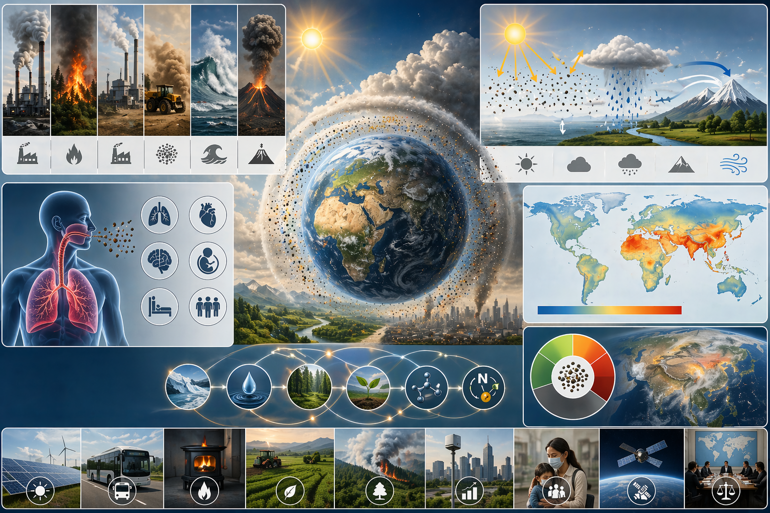
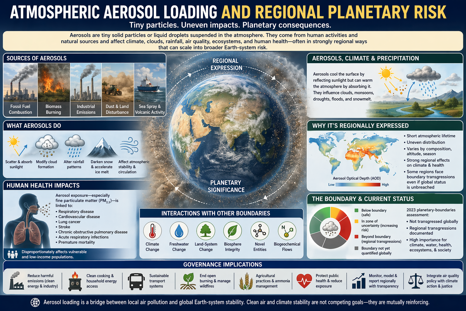
Atmospheric aerosol loading occupies a distinctive place in the planetary boundaries framework because it is one of the clearest examples of a boundary process that is planetary in significance but strongly regional in expression. Aerosols are tiny solid particles or liquid droplets suspended in the atmosphere. They are produced by fossil-fuel combustion, biomass burning, industrial emissions, transport, agricultural burning, mineral dust, sea spray, volcanic activity, wildfires, land degradation, household solid-fuel use, and other human and natural processes. They matter because they affect climate, clouds, precipitation, air quality, ecosystem health, cryosphere dynamics, food systems, and human health, often in ways that are spatially uneven and scientifically complex.
In the planetary boundaries framework, atmospheric aerosol loading is therefore not treated as a simple global-average problem. It is treated as a regional atmospheric force with consequences that can scale into broader Earth-system risk. Unlike carbon dioxide, aerosols do not mix evenly through the atmosphere over long time horizons, nor do they produce one straightforward planetary signal. Their effects vary by region, composition, altitude, season, particle size, optical properties, cloud interactions, hydrological sensitivity, and atmospheric circulation. Yet the very fact that aerosols have such strong regional effects makes them potentially destabilizing at larger scales, especially where they affect monsoon systems, precipitation regimes, snow and ice melt, public health, food systems, and the wellbeing of densely populated societies.
Main Library
Publications
Article Map
Planetary Boundaries
Related Article
Climate Change
Related Article
Ozone Depletion
This makes aerosol loading unusually important and unusually difficult. The planetary-boundary literature has approached aerosol loading with caution, recognizing its importance while also acknowledging that no single globally aggregated boundary captures all of its risks. Current planetary-boundary assessments do not classify atmospheric aerosol loading as globally transgressed, but they explicitly recognize regional transgressions and severe regional impacts. That distinction is central: aerosol loading can remain formally within the global safe operating space while still imposing severe regional harm and contributing to planetary instability through climate, hydrological, cryosphere, ecological, and health pathways.
Aerosol loading therefore expands the logic of planetary-boundary thinking. It shows that planetary risk is not always captured through one global mean, one universal threshold, or one evenly distributed process. Some risks become planetary because of where they occur, how they interact with regional circulation, how many people they expose, how they alter water systems and monsoons, how they darken snow and ice, and how they intersect with unequal vulnerability. Aerosol loading is not only a pollution problem. It is a test case for regional planetary risk.
This article examines atmospheric aerosol loading as a planetary-boundary process by explaining what aerosols are, why they matter, why the boundary is regionally expressed, how aerosols affect climate and precipitation, how particulate exposure affects human health, why aerosol composition matters, why a single global threshold remains difficult to define, how aerosol loading interacts with other planetary boundaries, and why regional atmospheric disruption can still be planetary in meaning.
Why Atmospheric Aerosol Loading Matters
Atmospheric aerosol loading matters because aerosols influence both the physical climate system and the conditions of everyday life. They scatter and absorb sunlight, affect cloud formation, alter rainfall patterns, shape regional temperature trends, darken snow and ice surfaces, and contribute directly to respiratory and cardiovascular disease. This gives aerosol loading a dual significance within the planetary boundaries framework. It is both an Earth-system process and a major human exposure pathway.
The planetary significance of aerosols lies partly in their influence on regional climate systems. Aerosols can cool the surface by reflecting sunlight, warm parts of the atmosphere by absorbing radiation, and modify cloud properties in ways that alter when, where, and how precipitation falls. In some regions, these effects influence monsoon dynamics, drought risk, flood risk, snow and ice melt, hydrological variability, agricultural stability, and regional climate extremes. Unlike some other boundaries, aerosol loading is not important because it generates one single planetary-average effect. It is important because regional atmospheric disturbance can produce wider instability in coupled climate, water, food, health, and social systems.
This makes the aerosol boundary especially valuable conceptually. It shows that Earth-system risk is not always best captured through globally well-mixed gases or a single scalar control variable. Some risks arise through spatial concentration, atmospheric circulation, regional amplification, and unequal human exposure. Aerosol loading is therefore one of the clearest examples of how the planetary boundaries framework must accommodate uneven geographies of destabilization.
Aerosol loading also matters because it complicates ordinary climate policy narratives. Some aerosols cool the planet by reflecting sunlight, while others warm the atmosphere or accelerate snow and ice melt. Reducing particulate pollution is essential for public health, but changes in aerosol emissions can also alter regional and global radiative balance. This does not weaken the case for clean air. It strengthens the case for integrated governance that reduces both greenhouse gases and harmful aerosols while anticipating the climatic consequences of changing atmospheric composition.
The boundary also matters because aerosol harms can be immediate. Climate change often operates through long-term accumulation, although its impacts are now visible in present extremes. Aerosols, by contrast, can affect human health, visibility, local air quality, and regional atmospheric conditions on much shorter time scales. This gives aerosol governance unusual potential for near-term benefit. Reductions in harmful particulate emissions can improve public health quickly, while also reducing black carbon, combustion-related pollutants, and some regional climate pressures.
At the same time, aerosol governance cannot be simplistic. Because aerosol cooling has masked some greenhouse warming, removing reflective aerosols without rapid greenhouse-gas mitigation can reveal additional warming. The solution is not to preserve dirty air. The solution is to decarbonize while cleaning the air, so that health protection and climate stabilization advance together.
What Aerosols Are
Aerosols are minute solid particles or liquid droplets suspended in the atmosphere. Some are natural, such as sea salt, volcanic particles, biogenic particles, wildfire smoke, mineral dust, pollen fragments, and marine aerosols. Others are strongly influenced by human activity, including sulfate aerosols from coal and industrial sulfur emissions, black carbon from incomplete combustion, organic carbon from biomass burning, nitrate and ammonium particles from agricultural and combustion-related precursors, construction dust, transport particles, and industrial particulate emissions.
Their climatic and health effects depend heavily on composition, size, altitude, location, atmospheric lifetime, optical properties, surface deposition, and interactions with clouds and radiation. This diversity is one reason aerosol loading is such a difficult boundary to assess. There is no single aerosol type in a chemically unified sense. Different aerosols have different effects. Some tend to cool more strongly by scattering sunlight. Some warm the atmosphere by absorbing radiation. Some are especially harmful to health because they penetrate deeply into the lungs or bloodstream. Some affect cloud microphysics, precipitation efficiency, atmospheric stability, or regional circulation.
Particle size also matters. Fine particulate matter, especially PM2.5, is central to public health because particles small enough to penetrate deep into the respiratory system are associated with severe health burdens. Larger particles such as PM10 also matter, but the smallest particles often create more serious health risks because of their capacity to enter deeper biological pathways. In climate analysis, size affects optical behavior, cloud interactions, lifetime, transport distance, and deposition.
Aerosols may be primary or secondary. Primary aerosols are emitted directly as particles, such as dust, sea salt, soot, or smoke. Secondary aerosols form in the atmosphere from precursor gases such as sulfur dioxide, nitrogen oxides, ammonia, and volatile organic compounds. This distinction matters because controlling aerosols often requires controlling the gases that form them, not only visible particles themselves.
Aerosols also differ by altitude. Near-surface particulate pollution is closely tied to human exposure, urban air quality, household energy, transport, and industrial emissions. Aerosols higher in the atmosphere can influence radiation, clouds, circulation, and deposition patterns. Stratospheric particles, volcanic aerosols, and proposed stratospheric aerosol injection raise different concerns from urban PM2.5, even though both belong to the wider field of aerosol loading.
That internal diversity explains why the politics of aerosol control are complex. Measures that reduce one class of particulate emissions may have different climatic implications from measures aimed at another, even when both are beneficial for health. Scientifically, this is a reminder that aerosol loading is best treated as a structured field of atmospheric perturbation rather than as a single pollutant category.
| Aerosol type | Common sources | Major risks and effects |
|---|---|---|
| Black carbon | Diesel engines, biomass burning, household solid fuels, flaring, incomplete combustion. | Absorbs sunlight, warms the atmosphere, harms health, and accelerates snow and ice melt when deposited on bright surfaces. |
| Sulfate aerosols | Coal combustion, industrial sulfur emissions, shipping, volcanic sources. | Scatter sunlight and often cool climate, while contributing to air pollution, haze, and acid-deposition concerns. |
| Nitrate and ammonium aerosols | Nitrogen oxides, ammonia from agriculture and waste systems, combustion-related precursors. | Contribute to PM2.5 exposure, visibility loss, nutrient deposition, and air-quality burdens. |
| Organic aerosols | Biomass burning, wildfires, vegetation emissions, combustion, secondary atmospheric chemistry. | Influence air quality, cloud properties, radiation, and regional smoke exposure. |
| Mineral dust | Drylands, degraded land, agriculture, drought, wind erosion, construction, desert sources. | Affects radiation, clouds, nutrient transport, respiratory exposure, snow darkening, and regional atmospheric conditions. |
| Sea salt | Ocean spray and marine atmospheric processes. | Important natural aerosol influencing clouds, radiation, and marine-atmosphere exchange. |
Aerosols are therefore not one thing. They are a heterogeneous atmospheric system. That heterogeneity is exactly why they are scientifically difficult and politically important.
Why the Boundary Is Regionally Expressed
The planetary-boundaries literature has long emphasized that atmospheric aerosol loading is best understood as a regional boundary process. The original framework could not define a single global boundary level for aerosols in the same way as for some other processes, and later updates continued to emphasize the difficulty of identifying one universal global threshold. Instead, the literature highlighted regional boundary conditions, especially in relation to monsoon systems, aerosol optical depth, and regional atmospheric disruption.
This regional emphasis reflects how aerosols behave in the atmosphere. Their lifetimes are much shorter than that of carbon dioxide, and their concentrations vary sharply across regions. As a result, their strongest effects are often concentrated near major emission regions or along particular circulation pathways. Yet those regional effects can alter monsoons, precipitation systems, cryosphere conditions, and human exposure in ways that are severe enough to justify planetary-boundary attention. The boundary is therefore regionally expressed but globally significant.
This is one of the more intellectually important features of the aerosol boundary. It expands the logic of planetary boundaries beyond globally averaged signals and forces the framework to take seriously the possibility that regional atmospheric disruption can have system-wide consequences. In that respect, aerosol loading increases the conceptual sophistication of the framework itself.
Regional expression also changes the ethics of interpretation. A globally averaged status can conceal severe local and regional harm. A region with intense particulate exposure, disrupted rainfall, black-carbon deposition, high population density, weak health infrastructure, and limited governance capacity may face planetary-boundary-relevant risk even if the global classification remains formally within the safe zone. Aerosol loading therefore shows why planetary analysis must pay attention to geography, exposure, and unequal vulnerability.
Monsoon regions are especially important in this boundary because aerosol loading can alter atmospheric heating gradients, cloud processes, surface radiation, and precipitation dynamics. A shift in monsoon timing or intensity can affect food production, water availability, flood risk, public health, and livelihoods for hundreds of millions of people. Regional atmospheric disruption can therefore become a planetary concern because the affected systems are socially, ecologically, and hydrologically consequential.
The regional nature of aerosol loading also means that governance cannot rely only on global averages. It needs regional diagnostics: aerosol optical depth, PM2.5 exposure, black carbon, sulfate and nitrate composition, dust burden, population exposure, cloud sensitivity, monsoon sensitivity, snow and ice deposition, and vulnerability indicators. A global boundary may guide Earth-system interpretation, but regional monitoring guides action.
Aerosols, Climate, and Precipitation
Aerosols affect climate through several pathways. They can scatter incoming solar radiation and cool the surface, absorb radiation and warm the atmosphere, and modify the number and properties of cloud droplets, which in turn affects cloud brightness, cloud lifetime, precipitation efficiency, and rainfall distribution. These effects help explain historical regional dimming and brightening patterns as aerosol emissions rose and later declined in some places. They also help explain why aerosol forcing often has a strong regional footprint in precipitation and temperature patterns.
These climatic effects matter because water systems, agriculture, ecosystems, and human settlements depend on precipitation patterns and seasonal stability. Aerosol emissions have been linked to regional cooling, changes in rainfall, and disturbances in monsoon dynamics. In Earth-system terms, this means aerosol loading can influence not just local air quality but the broader circulation of water and energy through the climate system. That is one reason the planetary boundaries framework treats aerosol loading as a serious regional threat even without a single universal global threshold.
Aerosol loading therefore belongs in the same analytical conversation as hydrological instability and land-atmosphere coupling. It shows how atmospheric composition can reshape not only temperature but the spatial and seasonal organization of rainfall itself. A shift in aerosol concentration over a major source region can affect atmospheric heating gradients, cloud properties, and regional circulation. Those changes can then propagate into food production, freshwater availability, disaster risk, and ecosystem resilience.
One of the most difficult features of aerosol climate forcing is that it can mask part of greenhouse-gas warming while simultaneously harming health and disrupting regional systems. This produces a governance problem: reducing aerosols is necessary for health and air quality, but it must occur alongside rapid greenhouse-gas reduction so that the removal of aerosol cooling does not reveal additional warming without compensating climate mitigation. Aerosol governance therefore has to be integrated with decarbonization, not treated as a separate environmental cleanup issue.
Cloud interactions are particularly complex. Aerosols can serve as cloud condensation nuclei or ice nuclei, affecting droplet number, droplet size, cloud reflectivity, cloud lifetime, and precipitation formation. These interactions are one of the reasons aerosol forcing remains scientifically challenging. A region’s aerosol burden may affect cloud brightness and rainfall differently depending on particle type, meteorology, humidity, cloud regime, altitude, and background atmospheric conditions.
Precipitation effects are especially important for sustainable development. Rainfall reliability shapes crops, hydropower, drinking-water systems, groundwater recharge, flood risk, urban drainage, ecosystem productivity, and climate adaptation. If aerosol loading affects monsoon systems or suppresses rainfall in vulnerable regions, it becomes a development issue as much as an atmospheric-science issue.
Aerosols and Human Health
Aerosol loading is one of the most direct links between planetary-boundary thinking and human bodily vulnerability. Fine particulate matter is associated with major health harms, including respiratory disease, cardiovascular disease, lung cancer, stroke, chronic obstructive pulmonary disease, acute respiratory infections, adverse pregnancy outcomes, and premature mortality. The health burden of ambient air pollution remains severe across much of the world, especially in densely populated, highly industrialized, biomass-burning, wildfire-exposed, or solid-fuel-dependent regions.
This health dimension matters conceptually because it reveals how Earth-system destabilization and human welfare are not separate concerns. In aerosol loading, the same atmospheric perturbations that affect clouds, temperature, and rainfall also directly damage human lungs, hearts, brains, immune systems, health systems, and communities. This is one reason safe-and-just Earth-system boundary work gives atmospheric aerosol loading special attention: justice considerations can constrain acceptable exposure more strongly than purely system-level safety considerations alone.
Aerosol loading is therefore a bridge concept between planetary risk and public health. It shows with unusual immediacy that atmospheric destabilization is not an abstraction. It is experienced in bodies, cities, health systems, workplaces, schools, elderly care, informal settlements, rural households, transport corridors, industrial zones, fire-prone landscapes, and unequal patterns of exposure. The planetary-boundary framing does not replace public-health air-quality standards; it broadens the interpretation by connecting exposure to Earth-system processes and regional climate stability.
The health burden also reinforces the importance of clean energy, clean cooking, industrial emission controls, transport reform, urban design, wildfire prevention, agricultural burning reduction, waste management, occupational exposure protection, and public-health preparedness. Aerosol governance is not only about atmospheric chemistry. It is about the everyday infrastructure of combustion, housing, mobility, industry, land use, food systems, public health, and energy access.
Health exposure also makes the aerosol boundary morally urgent. A regional aerosol burden may be scientifically complex, but its social consequences are brutally concrete. Children with asthma, outdoor workers, elderly people, pregnant people, people with cardiovascular disease, communities near industrial corridors, residents of informal settlements, and households dependent on solid fuels can experience aerosol loading as daily harm. Any planetary-boundary interpretation that ignores this lived exposure would be incomplete.
Air-quality governance therefore needs both measurement and justice. Monitoring stations, satellite products, exposure models, hospital data, occupational health records, and community-based observation should inform policy. But the goal is not only to know where particles are. It is to reduce exposure, protect vulnerable people, and transform the systems producing the pollution in the first place.
Black Carbon, Sulfates, Dust, and Composition
Aerosol composition matters because different particle types can have very different effects. Sulfate aerosols generally scatter sunlight and have a cooling influence, although they also contribute to air pollution and acid-deposition concerns. Black carbon absorbs sunlight, warms the atmosphere, can alter cloud and precipitation processes, and accelerates snow and ice melt when deposited on bright surfaces. Organic carbon, nitrates, ammonium, dust, and sea salt each have their own optical, chemical, and microphysical properties.
Black carbon is especially important because it connects incomplete combustion, health damage, regional warming, and cryosphere risk. Sources include diesel engines, biomass burning, residential solid-fuel use, flaring, shipping, and some industrial processes. Reducing black carbon can often provide health and climate co-benefits, especially where emissions occur near snow and ice regions or densely populated areas. But black carbon is also mixed with other aerosols, making net effects dependent on source composition and atmospheric context.
Sulfate aerosols illustrate the opposite problem. They often cool the climate by reflecting sunlight and brightening clouds, but they also contribute to particulate pollution and can be associated with sulfur dioxide emissions, haze, acid deposition, and health concerns. Reducing sulfate pollution is beneficial for health and ecosystems, but it may reduce aerosol cooling. This is one reason air-pollution policy must be paired with greenhouse-gas mitigation: societies should not rely on pollution to mask warming.
Dust also illustrates the boundary’s complexity. Some dust is natural, but land degradation, drought, agriculture, deforestation, grazing pressure, and climate change can alter dust emissions. Dust can affect radiation, cloud formation, nutrient transport, air quality, and ocean fertilization. It can also carry pathogens, pollutants, metals, pesticides, or chemical residues. In dryland regions, aerosol loading may therefore connect directly to land-system change, freshwater stress, agricultural practices, and human health.
Nitrate and ammonium particles connect aerosol loading to agriculture and biogeochemical flows. Ammonia emissions from livestock, fertilizers, and waste systems can react with acidic compounds to form fine particulate matter. Nitrogen oxides from transport, industry, and combustion can also contribute to secondary aerosol formation. This means aerosol loading is not only an energy or transport issue; it is also a nutrient-management issue.
The compositional diversity of aerosols reinforces a central lesson: aerosol loading cannot be governed intelligently through one aggregate number alone. Effective governance requires source-specific, region-specific, and composition-aware strategies that account for both climate and health effects.
Wildfire Smoke, Dust, and Land-Atmosphere Feedbacks
Wildfire smoke and dust show how aerosol loading can emerge from land-atmosphere feedbacks rather than only from smokestacks, tailpipes, or industrial facilities. As climate change intensifies heat, drought, vapor-pressure deficits, and fire weather in many regions, wildfire smoke can become a major source of episodic aerosol exposure. These events can travel long distances, affect urban air quality far from the fire, disrupt outdoor work and schooling, burden health systems, and alter regional atmospheric conditions.
Wildfire smoke contains a complex mixture of fine particles, organic aerosols, black carbon, gases, and toxic compounds. Its health effects can be severe because smoke episodes may expose large populations to high PM2.5 concentrations over short periods. Its climate effects depend on particle composition, altitude, cloud interactions, deposition, and atmospheric context. Smoke also reveals why aerosol loading is increasingly connected to climate adaptation: fire regimes are not independent of warming, land management, drought, and ecosystem resilience.
Dust operates through a related but distinct pathway. Dry soils, degraded landscapes, deforestation, overgrazing, drought, agricultural disturbance, and construction can increase dust emissions. Dust storms can damage respiratory health, reduce visibility, disrupt transport, deposit nutrients or contaminants, influence clouds and radiation, and darken snow or ice when transported to cryosphere regions. Dust therefore links aerosol loading to land-system change, freshwater stress, desertification, and rural livelihoods.
These feedbacks complicate governance because the source of aerosol loading may not be a single industrial stack. It may be a landscape condition. Fire management, forest stewardship, peatland protection, drought preparedness, soil conservation, grazing management, agricultural practice, urban-wildland planning, and ecosystem restoration can all become aerosol governance tools.
This is a crucial point for planetary-boundary thinking. Aerosols are atmospheric, but their sources and consequences are often terrestrial, social, and ecological. A burned forest, degraded dryland, drained peatland, exposed soil, or overheated city can all become part of the aerosol system. The atmosphere records the condition of the land.
Wildfire smoke and dust also emphasize the need for near-real-time monitoring. Smoke plumes and dust events can change quickly, move across borders, and expose populations that are not near the original source. Regional aerosol governance therefore requires satellite observations, ground monitors, forecasting systems, emergency communication, public-health planning, and cross-border cooperation.
Why a Single Global Threshold Is Difficult
One of the defining challenges of the aerosol boundary is that no single global threshold captures its risks well. Aerosol composition varies. Radiative effects vary. Atmospheric lifetimes are short. Concentrations are regional. Impacts on health and precipitation are uneven. Interactions with clouds remain one of the more complex areas of climate science. All of this makes a universal aggregate threshold difficult to define with the same confidence available for some other planetary processes.
That difficulty should not be mistaken for insignificance. The aerosol boundary is hard to define globally because it is complex, not because it is trivial. Indeed, the planetary-boundary framework includes aerosol loading precisely because regional atmospheric disruption can be so consequential. The absence of a tidy global threshold is therefore a reason for analytical caution, not a reason to exclude the problem from Earth-system thinking.
The measurement challenge is partly methodological. Aerosol optical depth can indicate how much light particles prevent from passing through the atmosphere, but it does not fully capture composition, altitude, health exposure, cloud effects, or precipitation consequences. PM2.5 can capture health-relevant fine particulate exposure, but it does not directly represent all radiative and cloud-mediated effects. Black-carbon concentration can capture an important warming and health-related component, but not the full aerosol system. Regional monsoon metrics can reveal hydrological disruption, but not total exposure or cryosphere effects. The boundary therefore requires plural indicators.
This is a useful reminder that not all serious planetary risks are equally legible to simple metrics. Some require regional interpretation, source-specific analysis, exposure assessment, atmospheric modeling, health data, and a more careful theory of scaling from local processes to system-wide consequence.
The difficulty also reflects a deeper conceptual issue. Aerosols can be harmful and cooling at the same time. This creates an uncomfortable accounting problem. A simple climate metric might treat sulfate aerosols as cooling, while a public-health metric treats them as harmful. A regional hydrology metric might focus on monsoon disruption, while a health-equity metric focuses on PM2.5 exposure. A boundary framework must therefore resist reducing aerosols to only one kind of value.
The strongest interpretation is plural and regional: aerosol loading should be assessed through multiple indicators that include aerosol optical depth, PM2.5 exposure, composition, black carbon, radiative forcing, cloud interactions, precipitation effects, population exposure, vulnerability, and governance capacity. The absence of one perfect number is not a weakness. It is a sign that the system must be measured with the complexity it deserves.
The Boundary and Its Current Status
Current planetary-boundary assessments treat atmospheric aerosol loading as within the global safe operating space, while emphasizing severe regional impacts and regional safe-level exceedances. The current Planetary Health Check framing uses the interhemispheric difference in aerosol optical depth as the global control variable. It also recognizes that local aerosol optical depth correlates with PM2.5 exposure and that this is especially important for justice considerations related to human health.
This status should be interpreted carefully. It does not mean aerosol loading is safe everywhere or unimportant. It means the current planetary-boundary assessment does not identify a globally transgressed aggregate threshold in the same way it does for climate change, biosphere integrity, land-system change, freshwater change, biogeochemical flows, ocean acidification, or novel entities. Regional danger, however, remains central to the interpretation of the boundary.
In other words, aerosol loading is one of the clearest examples of a process that can remain globally unbreached in formal classification while still imposing severe regional harms and destabilizing pressures. That is exactly why it belongs in the framework. It reminds readers that planetary risk is not always synonymous with global uniformity.
The current status also implies a governance opportunity. Because the boundary is not globally classified as transgressed, aggressive regional air-quality and emission-reduction strategies can still reduce risk before aerosol loading becomes more destabilizing. Unlike some slower-moving Earth-system changes, aerosol concentrations can respond relatively quickly to emission changes. That makes aerosol governance one of the areas where strong policy can produce relatively near-term health and atmospheric benefits, provided it is coordinated with greenhouse-gas mitigation.
| Assessment dimension | Current interpretation | Why it matters |
|---|---|---|
| Global control variable | Interhemispheric difference in aerosol optical depth. | Captures large-scale imbalance between hemispheres, but does not fully represent local exposure or composition. |
| Global status | Currently within the global safe operating space. | Indicates no formal global transgression under the current control variable. |
| Regional status | Severe regional impacts and regional exceedances remain central. | Shows why aerosol loading can be regionally dangerous even without global transgression. |
| Regional reference | Provisional regional aerosol optical depth boundary used especially for monsoon regions. | Connects aerosol loading to precipitation, hydrological stability, biosphere integrity, and justice concerns. |
| Health interpretation | Local aerosol loading correlates with PM2.5 exposure. | Links the boundary to public health, inequality, and exposure justice. |
The boundary’s current status should therefore be read as a call for regional precision. Global classification alone is insufficient. Aerosol loading must be governed where people breathe it, where monsoons are affected, where snow and ice are darkened, where fires and dust intensify, and where vulnerable populations are exposed.
Aerosol Justice and Unequal Exposure
Atmospheric aerosol loading is a justice issue because exposure is profoundly unequal. People do not breathe global averages. They breathe the air in specific streets, homes, schools, farms, industrial corridors, transport routes, wildfire regions, construction zones, kitchens, factories, and cities. A global safe-zone classification can coexist with intense local exposure, especially for low-income communities, children, elderly people, outdoor workers, people with chronic illness, and communities near major combustion or dust sources.
The injustice is not only biological exposure. It is also political and infrastructural. Some communities lack air-quality monitoring. Some lack clean household energy. Some live near highways, ports, refineries, coal plants, industrial zones, brick kilns, waste-burning sites, or extractive operations. Some are exposed to agricultural burning, dust storms, wildfire smoke, or poorly regulated urban growth. Some lack health systems capable of managing pollution-related disease. Aerosol risk is therefore produced by energy systems, land use, housing, transport, labor, governance, and inequality.
Air pollution also crosses borders. Smoke, dust, industrial emissions, and regional haze can move across political boundaries. Communities may be exposed to aerosols generated by distant fires, land-use practices, energy systems, or industrial activity. This makes aerosol justice a multiscale issue: local exposure, regional transport, national regulation, and global climate governance all interact.
Justice also requires attention to household air pollution and clean energy access. In many regions, households still depend on solid fuels for cooking or heating. These practices can expose women, children, and older people to high particulate levels indoors and contribute to outdoor pollution as emissions disperse. Clean cooking is therefore not a minor development issue. It is an aerosol-governance, health, gender, energy, and climate issue.
Aerosol justice also means data justice. Regions without monitoring infrastructure are not necessarily cleaner; they may simply be less visible. Satellite observations help, but ground monitors, local calibration, public health data, and community reporting remain essential. A serious aerosol strategy must not allow measurement gaps to become political invisibility.
In a safe-and-just Earth-system perspective, aerosol loading cannot be assessed only by whether the global control variable remains within bounds. It must also be assessed by whether people are being exposed to harmful air because of systems they did not design and cannot individually escape.
Interactions with Other Boundaries
Atmospheric aerosol loading interacts with several other planetary-boundary processes. It is linked to climate change because aerosols alter radiative forcing, regional temperature patterns, cloud properties, and the masking or revelation of greenhouse warming. It affects freshwater and hydrological conditions through its influence on rainfall, monsoons, snowmelt, and cloud processes. It can interact with biosphere integrity by altering light, heat, deposition, and moisture conditions that shape ecosystems. It is also entangled with land-system change and biomass burning, since fires, deforestation, peatland degradation, agricultural burning, and soil disturbance can be major aerosol sources.
These interactions help explain why aerosol loading is better understood as part of a wider Earth-system matrix than as an isolated air-pollution problem. Regional aerosol emissions can cascade into climate and water disruptions, while climate stress and land transformation can in turn alter aerosol regimes. Drought and heat can intensify wildfire smoke. Land degradation can increase dust. Energy systems can emit both greenhouse gases and aerosol precursors. Agricultural systems can contribute ammonia that forms secondary particulate matter. In that sense, aerosol loading exemplifies the interdependence that the planetary boundaries framework seeks to make visible.
Aerosol loading also interacts with novel entities. Industrial particles, combustion residues, heavy metals, chemical aerosols, microplastic fragments, tire and brake-wear particles, and secondary pollutants can carry toxicological significance beyond their role in radiation or clouds. The boundary therefore sits at the edge of climate science, atmospheric chemistry, toxicology, public health, and Earth-system governance.
The interaction with biogeochemical flows is particularly important. Ammonia from agriculture and nitrogen oxides from combustion contribute to secondary particulate matter. Nutrient management, livestock systems, fertilizer use, waste systems, and transport emissions can therefore shape aerosol burdens. Similarly, aerosols can deposit nitrogen, metals, dust, or contaminants into ecosystems and water bodies, linking air pollution to soils, freshwater, oceans, and biodiversity.
Stratospheric ozone depletion also provides an important comparison. Both aerosol loading and ozone depletion concern atmospheric chemistry, but the governance structures differ. Ozone depletion was addressed through a global treaty targeting identifiable substances. Aerosol loading requires more regionally differentiated governance across energy, transport, fire, agriculture, land, urban systems, and health policy. The comparison shows why each boundary needs governance suited to its causal structure.
For companion essays, see Climate Change as a Planetary Boundary, Freshwater Change and Earth System Risk, Land-System Change and Ecological Transformation, Novel Entities and the Problem of Synthetic Overload, Stratospheric Ozone Depletion and Global Environmental Governance, and Biosphere Integrity and the Stability of Life Systems.
Regional Risk and Planetary Significance
Atmospheric aerosol loading is an especially useful boundary for thinking about the relationship between regional disruption and planetary significance. Not every planetary-boundary process is best captured through a single global mean. Aerosol loading shows that a process can be regionally concentrated yet globally important because of how it affects monsoons, cryosphere change, air quality, food systems, public health, and densely populated human societies.
This makes aerosol loading one of the clearest cases where the planetary-boundary framework must stretch beyond simple global averaging. The Earth system can be destabilized through regionally intense processes whose aggregate significance comes from where and how they operate rather than from a single neat planetary number. In that sense, aerosol loading expands the conceptual sophistication of the framework itself.
It also suggests a broader methodological lesson: planetary analysis must sometimes be scalar rather than strictly globalist. Processes matter not only because they are everywhere, but because where they occur can be decisive for system stability. Aerosol loading over South Asia, East Asia, the Arctic, major fire regions, dryland dust corridors, or densely populated basins can matter in different ways because atmospheric circulation, snow and ice surfaces, monsoon dynamics, population exposure, and governance capacity differ.
Regional planetary risk therefore requires a more geographically literate form of systems analysis. A global dashboard can be useful, but it must be paired with regional diagnostics, exposure maps, source attribution, and vulnerability analysis. Aerosol loading makes that requirement impossible to ignore.
The concept also challenges a common misunderstanding of planetary boundaries. “Planetary” does not always mean evenly global. A regional process can be planetary if it affects Earth-system functions, major climate subsystems, large populations, food and water security, or cross-boundary feedbacks. The monsoon does not need to be global to be planetary in significance. The Arctic does not need to be densely populated to be planetary in significance. A heavily polluted regional atmosphere can matter far beyond the place where particles are emitted.
This is why aerosol loading belongs in the planetary boundaries framework even though its global threshold remains difficult. It forces sustainability science to recognize that Earth-system risk has geography. Where disruption happens can matter as much as how much disruption exists in a global average.
Monitoring Atmospheric Aerosol Loading
Monitoring atmospheric aerosol loading requires multiple kinds of data. Aerosol optical depth helps describe how much particles interfere with the passage of light through the atmosphere. PM2.5 and PM10 measurements help assess health-relevant exposure. Black carbon observations help identify warming, combustion, and cryosphere-relevant risk. Satellite retrievals, ground monitors, lidar, sun photometers, chemical transport models, emissions inventories, air-quality networks, meteorological data, and health datasets all contribute different parts of the picture.
No single monitoring system is sufficient. Satellites can provide broad spatial coverage but may struggle with near-surface exposure, cloud contamination, vertical distribution, and chemical composition. Ground monitors can measure local exposure more directly but may be sparse, especially in regions with high vulnerability. Atmospheric models can connect emissions, transport, chemistry, and deposition, but they depend on assumptions, inventories, and validation. Community monitoring can fill gaps, but it requires calibration, transparency, and support.
Aerosol monitoring also needs composition. A PM2.5 value alone cannot tell whether the particles are dominated by sulfates, black carbon, dust, organic carbon, nitrates, ammonium, sea salt, wildfire smoke, or industrial residue. Composition matters for health, climate, visibility, deposition, source attribution, and policy response. A region dominated by black carbon requires different interventions than a region dominated by dust or ammonium nitrate.
Monitoring must also connect exposure to vulnerability. A low aerosol concentration over a sparsely populated area may not have the same health meaning as a similar concentration over a dense urban corridor. A smoke event affecting children, outdoor workers, and people with respiratory disease has a different social meaning from a remote plume. Aerosol diagnostics should therefore include population exposure, age, health vulnerability, occupational risk, housing quality, health-system capacity, and access to protective infrastructure.
For planetary-boundary analysis, monitoring must also track regional climate and hydrological effects. Monsoon sensitivity, precipitation shifts, cloud responses, snow and ice deposition, wildfire feedbacks, and dust mobilization all require data beyond conventional urban air-quality metrics. Aerosol loading is a coupled atmospheric-health-climate problem, and monitoring systems should be designed accordingly.
A mature aerosol-monitoring architecture should therefore include open data, regional calibration, uncertainty metadata, source attribution, composition, exposure justice, and reproducible workflows. Without that architecture, aerosol dashboards risk simplifying the problem into a number that hides the very regional complexity that makes the boundary important.
Governance Implications
If atmospheric aerosol loading is a boundary process of regional planetary risk, then governance cannot be confined to narrow air-pollution control alone, though air-pollution policy remains essential. Effective governance must connect climate policy, energy systems, industrial emissions, land burning, transport regulation, health policy, urban planning, agricultural ammonia management, wildfire risk reduction, clean cooking, waste management, dust control, and regional atmospheric monitoring. It must also account for the fact that reducing aerosols can have mixed climatic effects, especially where aerosol cooling has temporarily masked part of greenhouse-gas warming.
This makes aerosol governance unusually demanding. Societies cannot treat it as either a pure climate problem or a pure health problem. It is both, and more than both. The governance challenge is to reduce harmful aerosol exposure and regional atmospheric disruption while also managing the wider climate implications of rapid emission changes. That is precisely the kind of integrated, cross-system thinking the planetary boundaries framework was built to encourage.
This also means aerosol governance is a test of policy coordination. Energy transition, clean cooking, industrial controls, transport reform, wildfire management, dust control, agricultural nutrient management, and health regulation all converge in this boundary in unusually direct ways. A coal plant, diesel fleet, crop-burning practice, wildfire regime, construction corridor, livestock system, household solid-fuel system, or degraded dryland can be simultaneously a health risk, climate-forcing source, regional atmospheric disturbance, and justice issue.
The governance lesson is therefore not only to reduce aerosols. It is to reduce them intelligently, rapidly, equitably, and in coordination with greenhouse-gas mitigation. Clean air and climate stability should not be treated as competing goals. They are mutually reinforcing when policy is designed around both near-term health protection and long-term Earth-system stability.
Different sources require different strategies. Coal and industrial sulfur emissions require clean energy, industrial controls, and transition planning. Diesel and transport emissions require electrification, public transit, freight reform, low-emission fuels, and urban design. Household solid-fuel use requires clean cooking access and energy justice. Agricultural ammonia requires livestock and fertilizer management. Wildfire smoke requires land stewardship, fire management, climate adaptation, and public-health preparedness. Dust requires soil conservation, dryland resilience, and land-use governance.
Aerosol governance also requires public legitimacy. People are more likely to support air-quality policy when benefits are visible, health-relevant, and fairly distributed. Clean-air policy can build trust when it protects vulnerable communities, reduces disease burden, improves urban life, and connects local benefits to planetary stability. In this sense, aerosol governance may be one of the strongest bridges between planetary boundaries and everyday public wellbeing.
For adjacent essays, see Earth System Governance in an Age of Limits, Business Strategy Within Planetary Boundaries, Finance, Disclosure, and Systemic Environmental Risk, and Environmental Monitoring Systems.
Why This Matters for Planetary Boundaries
Atmospheric aerosol loading matters for planetary boundaries because it shows that Earth-system destabilization can be regional, uneven, and still planetary in meaning. Aerosols do not behave like carbon dioxide. They are shorter-lived, more spatially concentrated, compositionally diverse, and strongly tied to local sources. Yet they can affect monsoons, clouds, precipitation, cryosphere systems, climate forcing, public health, food security, and human vulnerability. Their regionality is not a reason to dismiss them. It is the reason they require careful boundary thinking.
The boundary also matters because it connects planetary science directly to human bodies. Fine particulate matter is not an abstract Earth-system variable. It is breathed. It enters homes, lungs, schools, workplaces, hospitals, and cities. It damages health while also participating in climate and hydrological processes. Aerosol loading is therefore one of the clearest examples of why planetary stability and human wellbeing cannot be separated.
Aerosol loading also matters because it complicates easy environmental narratives. Some aerosol reductions improve health but reveal warming if greenhouse gases are not reduced quickly. Some particles cool; others warm. Some are natural; others are industrial. Some effects are global; others are regional. Some risks are chemical; others are social. This complexity does not weaken the boundary. It makes the boundary intellectually important.
Finally, aerosol loading matters because it demands integrated governance. Clean air, decarbonization, clean cooking, industrial transition, transport reform, agricultural management, wildfire resilience, dust control, and public-health protection must be designed together. The boundary teaches that planetary stewardship is not only about setting global targets. It is also about governing the regional atmospheric systems through which people live, breathe, farm, travel, and adapt.
To understand atmospheric aerosol loading as a planetary-boundary process is to understand that the atmosphere’s smallest particles can shape some of the largest questions of planetary stability: climate, water, health, justice, food security, and the regional foundations of a safe operating space.
Mathematical Lens: Aerosol Optical Depth, Regional Exposure, and Planetary Risk
Atmospheric aerosol loading can be modeled through regional pressure, exposure, radiative forcing, and hydrological sensitivity. Let \(AOD_r\) represent aerosol optical depth in region \(r\), and let \(B_r\) represent a regional boundary or risk reference value. A simple regional aerosol pressure ratio can be written as:
R_r = \frac{AOD_r}{B_r}
\]
Interpretation: If \(R_r < 1\), aerosol loading remains below the chosen regional reference. If \(R_r \geq 1\), regional aerosol loading has entered a zone of increasing concern.
Because aerosol risks differ by composition, a weighted aerosol pressure score can include multiple aerosol classes:
P_r = \sum_{i=1}^{n} w_i C_{ir}
\]
Interpretation: \(C_{ir}\) is the concentration or index value for aerosol class \(i\) in region \(r\), and \(w_i\) represents its climate, health, or hydrological weight.
A health-exposure score can be written as:
H_r = PM_{2.5,r} \times Pop_r \times V_r
\]
Interpretation: Aerosol health risk depends not only on PM2.5 concentration, but also on exposed population and vulnerability.
A regional climate-disruption score can include radiative forcing \(F_r\), cloud interaction uncertainty \(\sigma_{c,r}\), and hydrological sensitivity \(S_{h,r}\):
C_r = |F_r|(1 + \sigma_{c,r})S_{h,r}
\]
Interpretation: Climate-disruption risk rises when forcing is strong, cloud uncertainty is high, and regional hydrology is sensitive.
A combined regional planetary-risk score can then be represented as:
G_r = \alpha R_r + \beta H_r + \gamma C_r + \delta J_r
\]
Interpretation: Regional planetary aerosol risk can combine aerosol pressure, health exposure, climate-hydrology effects, and justice-relevant vulnerability.
| Term | Meaning | Interpretive role |
|---|---|---|
| \(AOD_r\) | Aerosol optical depth in region \(r\) | Represents how much aerosols reduce light transmission through the atmosphere. |
| \(B_r\) | Regional boundary or risk reference | Provides a regionally relevant comparison value. |
| \(PM_{2.5,r}\) | Fine particulate exposure | Represents health-relevant exposure to particles smaller than 2.5 micrometers. |
| \(Pop_r\) | Exposed population | Connects atmospheric concentration to human exposure. |
| \(V_r\) | Vulnerability | Represents health, social, occupational, and infrastructural susceptibility. |
| \(F_r\) | Radiative forcing | Represents warming or cooling influence from aerosols. |
| \(\sigma_{c,r}\) | Cloud-interaction uncertainty | Represents uncertainty in aerosol-cloud effects. |
| \(S_{h,r}\) | Hydrological sensitivity | Represents regional sensitivity of rainfall, monsoons, snowmelt, or water systems. |
| \(J_r\) | Justice-relevant burden | Represents unequal exposure, monitoring gaps, and vulnerability. |
This simplified formulation captures the central challenge of the aerosol boundary: regional aerosol risk is not only a question of particle loading. It is also a question of composition, exposure, atmospheric forcing, hydrological sensitivity, vulnerability, and governance capacity.
Advanced Python Workflow: Regional Aerosol Risk and Boundary Diagnostics
The following Python workflow models aerosol loading as a regional planetary-risk problem. It separates aerosol optical depth, PM2.5 exposure, black-carbon share, sulfate share, dust share, exposed population, vulnerability, hydrological sensitivity, cloud-interaction uncertainty, and governance capacity. The values are illustrative, but the structure can be adapted for satellite data, ground-based monitoring, atmospheric models, public-health datasets, and regional risk dashboards.
"""
Atmospheric aerosol loading regional planetary-risk workflow.

This workflow models aerosol loading using:
- aerosol optical depth
- PM2.5 exposure
- black carbon share
- sulfate share
- dust share
- exposed population index
- vulnerability
- hydrological sensitivity
- cloud interaction uncertainty
- governance capacity
- policy scenario testing

The values are illustrative. Replace them with documented satellite
retrievals, ground monitoring, atmospheric chemistry model outputs,
public-health data, emissions inventories, and transparent regional
assumptions before applied use.
"""

from __future__ import annotations

from dataclasses import dataclass
from pathlib import Path
from typing import Literal

import numpy as np
import pandas as pd


RiskClass = Literal[
    "lower_risk",
    "moderate_risk",
    "high_risk",
    "severe_risk",
]


@dataclass(frozen=True)
class AerosolRegion:
    """Regional aerosol-risk profile."""

    region: str
    aerosol_optical_depth: float
    regional_boundary_reference: float
    pm25_exposure: float
    black_carbon_share: float
    sulfate_share: float
    nitrate_ammonium_share: float
    organic_carbon_share: float
    dust_share: float
    exposed_population_index: float
    vulnerability_index: float
    hydrological_sensitivity: float
    cloud_uncertainty: float
    cryosphere_sensitivity: float
    governance_capacity: float
    monitoring_capacity: float


def build_aerosol_regions() -> pd.DataFrame:
    """
    Create illustrative regional aerosol data.

    These values are scaled for demonstration and are not official estimates.
    """
    regions = [
        AerosolRegion(
            region="south_asia_monsoon_region",
            aerosol_optical_depth=0.42,
            regional_boundary_reference=0.25,
            pm25_exposure=0.86,
            black_carbon_share=0.28,
            sulfate_share=0.34,
            nitrate_ammonium_share=0.20,
            organic_carbon_share=0.18,
            dust_share=0.12,
            exposed_population_index=0.92,
            vulnerability_index=0.78,
            hydrological_sensitivity=0.88,
            cloud_uncertainty=0.32,
            cryosphere_sensitivity=0.36,
            governance_capacity=0.42,
            monitoring_capacity=0.54,
        ),
        AerosolRegion(
            region="east_asia_industrial_corridor",
            aerosol_optical_depth=0.36,
            regional_boundary_reference=0.25,
            pm25_exposure=0.72,
            black_carbon_share=0.22,
            sulfate_share=0.42,
            nitrate_ammonium_share=0.24,
            organic_carbon_share=0.14,
            dust_share=0.10,
            exposed_population_index=0.86,
            vulnerability_index=0.58,
            hydrological_sensitivity=0.66,
            cloud_uncertainty=0.28,
            cryosphere_sensitivity=0.22,
            governance_capacity=0.56,
            monitoring_capacity=0.68,
        ),
        AerosolRegion(
            region="sub_saharan_biomass_burning_belt",
            aerosol_optical_depth=0.30,
            regional_boundary_reference=0.22,
            pm25_exposure=0.64,
            black_carbon_share=0.34,
            sulfate_share=0.18,
            nitrate_ammonium_share=0.12,
            organic_carbon_share=0.38,
            dust_share=0.22,
            exposed_population_index=0.70,
            vulnerability_index=0.74,
            hydrological_sensitivity=0.62,
            cloud_uncertainty=0.35,
            cryosphere_sensitivity=0.08,
            governance_capacity=0.38,
            monitoring_capacity=0.34,
        ),
        AerosolRegion(
            region="arctic_black_carbon_influence_zone",
            aerosol_optical_depth=0.18,
            regional_boundary_reference=0.16,
            pm25_exposure=0.26,
            black_carbon_share=0.46,
            sulfate_share=0.10,
            nitrate_ammonium_share=0.08,
            organic_carbon_share=0.20,
            dust_share=0.18,
            exposed_population_index=0.18,
            vulnerability_index=0.52,
            hydrological_sensitivity=0.80,
            cloud_uncertainty=0.30,
            cryosphere_sensitivity=0.92,
            governance_capacity=0.50,
            monitoring_capacity=0.58,
        ),
        AerosolRegion(
            region="middle_east_dust_corridor",
            aerosol_optical_depth=0.34,
            regional_boundary_reference=0.24,
            pm25_exposure=0.50,
            black_carbon_share=0.12,
            sulfate_share=0.16,
            nitrate_ammonium_share=0.10,
            organic_carbon_share=0.10,
            dust_share=0.52,
            exposed_population_index=0.62,
            vulnerability_index=0.60,
            hydrological_sensitivity=0.48,
            cloud_uncertainty=0.26,
            cryosphere_sensitivity=0.06,
            governance_capacity=0.46,
            monitoring_capacity=0.48,
        ),
        AerosolRegion(
            region="latin_america_fire_frontier",
            aerosol_optical_depth=0.24,
            regional_boundary_reference=0.22,
            pm25_exposure=0.46,
            black_carbon_share=0.32,
            sulfate_share=0.14,
            nitrate_ammonium_share=0.10,
            organic_carbon_share=0.42,
            dust_share=0.20,
            exposed_population_index=0.54,
            vulnerability_index=0.56,
            hydrological_sensitivity=0.58,
            cloud_uncertainty=0.24,
            cryosphere_sensitivity=0.08,
            governance_capacity=0.48,
            monitoring_capacity=0.46,
        ),
        AerosolRegion(
            region="europe_urban_industrial_region",
            aerosol_optical_depth=0.16,
            regional_boundary_reference=0.22,
            pm25_exposure=0.34,
            black_carbon_share=0.14,
            sulfate_share=0.32,
            nitrate_ammonium_share=0.28,
            organic_carbon_share=0.12,
            dust_share=0.08,
            exposed_population_index=0.68,
            vulnerability_index=0.34,
            hydrological_sensitivity=0.34,
            cloud_uncertainty=0.18,
            cryosphere_sensitivity=0.10,
            governance_capacity=0.74,
            monitoring_capacity=0.82,
        ),
    ]

    return pd.DataFrame([region.__dict__ for region in regions])


def classify_risk(score: float) -> RiskClass:
    """Classify regional aerosol risk."""
    if score < 1.0:
        return "lower_risk"
    if score < 2.0:
        return "moderate_risk"
    if score < 3.0:
        return "high_risk"
    return "severe_risk"


def score_aerosol_risk(data: pd.DataFrame) -> pd.DataFrame:
    """Calculate regional aerosol-loading risk diagnostics."""
    scored = data.copy()

    if (scored["regional_boundary_reference"] <= 0).any():
        raise ValueError("Regional boundary reference values must be positive.")

    scored["aod_pressure_ratio"] = (
        scored["aerosol_optical_depth"]
        / scored["regional_boundary_reference"]
    )

    scored["composition_weight"] = (
        1.35 * scored["black_carbon_share"]
        + 0.85 * scored["sulfate_share"]
        + 0.90 * scored["nitrate_ammonium_share"]
        + 0.75 * scored["organic_carbon_share"]
        + 0.70 * scored["dust_share"]
    )

    scored["health_exposure_score"] = (
        scored["pm25_exposure"]
        * scored["exposed_population_index"]
        * scored["vulnerability_index"]
    )

    scored["climate_hydrology_score"] = (
        scored["aod_pressure_ratio"]
        * (1 + scored["cloud_uncertainty"])
        * scored["hydrological_sensitivity"]
        * (1 + scored["composition_weight"])
    )

    scored["cryosphere_black_carbon_score"] = (
        scored["black_carbon_share"]
        * scored["cryosphere_sensitivity"]
        * scored["aod_pressure_ratio"]
    )

    scored["governance_gap"] = 1 - scored["governance_capacity"]
    scored["monitoring_gap"] = 1 - scored["monitoring_capacity"]

    scored["regional_planetary_risk_score"] = (
        0.30 * scored["aod_pressure_ratio"]
        + 0.30 * scored["health_exposure_score"]
        + 0.25 * scored["climate_hydrology_score"]
        + 0.15 * scored["cryosphere_black_carbon_score"]
    ) * (
        1 + 0.55 * scored["governance_gap"] + 0.45 * scored["monitoring_gap"]
    )

    scored["risk_class"] = scored["regional_planetary_risk_score"].apply(classify_risk)

    scored["dominant_driver"] = np.select(
        [
            scored["health_exposure_score"] > scored["climate_hydrology_score"],
            scored["black_carbon_share"] >= 0.30,
            scored["dust_share"] >= 0.40,
            scored["nitrate_ammonium_share"] >= 0.25,
            scored["monitoring_capacity"] < 0.50,
        ],
        [
            "health_exposure",
            "black_carbon_and_absorption",
            "dust_and_land_atmosphere_linkage",
            "agricultural_and_combustion_secondary_pm",
            "monitoring_capacity_gap",
        ],
        default="mixed_aerosol_climate_risk",
    )

    return scored.sort_values(
        "regional_planetary_risk_score",
        ascending=False,
    ).reset_index(drop=True)


def run_policy_scenarios(data: pd.DataFrame) -> pd.DataFrame:
    """
    Test how risk changes under policy scenarios.

    Scenarios include clean energy, clean cooking, transport reform,
    wildfire and burning reduction, dust control, and integrated regional policy.
    """
    scenarios = {
        "baseline": {
            "aod_multiplier": 1.00,
            "pm25_multiplier": 1.00,
            "black_carbon_multiplier": 1.00,
            "dust_multiplier": 1.00,
            "governance_gain": 0.00,
            "monitoring_gain": 0.00,
        },
        "clean_energy_and_industry": {
            "aod_multiplier": 0.78,
            "pm25_multiplier": 0.75,
            "black_carbon_multiplier": 0.82,
            "dust_multiplier": 1.00,
            "governance_gain": 0.10,
            "monitoring_gain": 0.08,
        },
        "clean_cooking_and_transport": {
            "aod_multiplier": 0.82,
            "pm25_multiplier": 0.70,
            "black_carbon_multiplier": 0.60,
            "dust_multiplier": 1.00,
            "governance_gain": 0.12,
            "monitoring_gain": 0.08,
        },
        "land_fire_and_dust_control": {
            "aod_multiplier": 0.84,
            "pm25_multiplier": 0.78,
            "black_carbon_multiplier": 0.72,
            "dust_multiplier": 0.62,
            "governance_gain": 0.14,
            "monitoring_gain": 0.10,
        },
        "integrated_regional_policy": {
            "aod_multiplier": 0.65,
            "pm25_multiplier": 0.60,
            "black_carbon_multiplier": 0.55,
            "dust_multiplier": 0.70,
            "governance_gain": 0.22,
            "monitoring_gain": 0.16,
        },
    }

    frames = []

    for scenario_name, params in scenarios.items():
        scenario = data.copy()

        scenario["aerosol_optical_depth"] = (
            scenario["aerosol_optical_depth"]
            * params["aod_multiplier"]
        )
        scenario["pm25_exposure"] = (
            scenario["pm25_exposure"]
            * params["pm25_multiplier"]
        )
        scenario["black_carbon_share"] = (
            scenario["black_carbon_share"]
            * params["black_carbon_multiplier"]
        )
        scenario["dust_share"] = (
            scenario["dust_share"]
            * params["dust_multiplier"]
        )
        scenario["governance_capacity"] = np.minimum(
            1.0,
            scenario["governance_capacity"] + params["governance_gain"],
        )
        scenario["monitoring_capacity"] = np.minimum(
            1.0,
            scenario["monitoring_capacity"] + params["monitoring_gain"],
        )

        scored = score_aerosol_risk(scenario)
        scored["scenario"] = scenario_name
        scored["rank"] = scored["regional_planetary_risk_score"].rank(
            ascending=False,
            method="dense",
        )
        frames.append(scored)

    return pd.concat(frames, ignore_index=True)


def main() -> None:
    """Run the aerosol-loading regional-risk workflow."""
    output_dir = Path(
        "articles/atmospheric-aerosol-loading-and-regional-planetary-risk/outputs"
    )
    output_dir.mkdir(parents=True, exist_ok=True)

    data = build_aerosol_regions()
    scored = score_aerosol_risk(data)
    scenarios = run_policy_scenarios(data)

    scored.to_csv(output_dir / "regional_aerosol_risk_scores.csv", index=False)
    scenarios.to_csv(output_dir / "aerosol_policy_scenarios.csv", index=False)

    display_columns = [
        "region",
        "aod_pressure_ratio",
        "health_exposure_score",
        "climate_hydrology_score",
        "cryosphere_black_carbon_score",
        "regional_planetary_risk_score",
        "risk_class",
        "dominant_driver",
    ]

    print("\nRegional aerosol risk scores:")
    print(scored[display_columns].round(3).to_string(index=False))

    print("\nScenario comparison:")
    print(
        scenarios[
            [
                "scenario",
                "region",
                "aod_pressure_ratio",
                "health_exposure_score",
                "climate_hydrology_score",
                "cryosphere_black_carbon_score",
                "regional_planetary_risk_score",
                "risk_class",
                "dominant_driver",
                "rank",
            ]
        ].round(3).to_string(index=False)
    )


if __name__ == "__main__":
    main()
This workflow is useful because it treats aerosol loading as a regional systems problem rather than a single global variable. It distinguishes aerosol optical depth, PM2.5 exposure, black-carbon contribution, hydrological sensitivity, cloud uncertainty, cryosphere sensitivity, population exposure, vulnerability, monitoring capacity, and governance capacity. That separation matters because different regions require different interventions. A monsoon region may require integrated climate-hydrology monitoring; an urban-industrial region may require transport and industrial controls; a biomass-burning region may require land, fire, and health governance together.
The scenario section also makes the policy logic visible. Clean energy and industry reduce combustion-related aerosols. Clean cooking and transport target health exposure and black carbon. Land, fire, and dust control reduce landscape-driven aerosol burdens. Integrated regional policy performs best because aerosol loading is not one-sector pollution. It is a coupled energy, land, health, climate, and governance problem.
Advanced R Workflow: Aerosol Boundary Dashboarding
The following R workflow prepares dashboard-ready outputs for regional aerosol-boundary analysis. It is designed for researchers, engineers, sustainability analysts, atmospheric modelers, health-risk teams, regional planners, and governance practitioners who need to compare aerosol pressure, exposure, composition, hydrological sensitivity, cryosphere sensitivity, monitoring capacity, and policy scenarios.
# Atmospheric aerosol loading and regional planetary-risk dashboard
#
# This workflow scores aerosol loading across regions using:
# - aerosol optical depth
# - regional boundary reference values
# - PM2.5 exposure
# - aerosol composition
# - exposed population
# - vulnerability
# - hydrological sensitivity
# - cloud interaction uncertainty
# - cryosphere sensitivity
# - governance and monitoring capacity
#
# Values are illustrative and should be replaced with documented satellite,
# ground-monitoring, atmospheric-model, emissions-inventory, and public-health
# data before applied use.

library(readr)
library(dplyr)
library(tidyr)

aerosol_regions <- tibble::tibble(
  region = c(
    "south_asia_monsoon_region",
    "east_asia_industrial_corridor",
    "sub_saharan_biomass_burning_belt",
    "arctic_black_carbon_influence_zone",
    "middle_east_dust_corridor",
    "latin_america_fire_frontier",
    "europe_urban_industrial_region"
  ),
  aerosol_optical_depth = c(0.42, 0.36, 0.30, 0.18, 0.34, 0.24, 0.16),
  regional_boundary_reference = c(0.25, 0.25, 0.22, 0.16, 0.24, 0.22, 0.22),
  pm25_exposure = c(0.86, 0.72, 0.64, 0.26, 0.50, 0.46, 0.34),
  black_carbon_share = c(0.28, 0.22, 0.34, 0.46, 0.12, 0.32, 0.14),
  sulfate_share = c(0.34, 0.42, 0.18, 0.10, 0.16, 0.14, 0.32),
  nitrate_ammonium_share = c(0.20, 0.24, 0.12, 0.08, 0.10, 0.10, 0.28),
  organic_carbon_share = c(0.18, 0.14, 0.38, 0.20, 0.10, 0.42, 0.12),
  dust_share = c(0.12, 0.10, 0.22, 0.18, 0.52, 0.20, 0.08),
  exposed_population_index = c(0.92, 0.86, 0.70, 0.18, 0.62, 0.54, 0.68),
  vulnerability_index = c(0.78, 0.58, 0.74, 0.52, 0.60, 0.56, 0.34),
  hydrological_sensitivity = c(0.88, 0.66, 0.62, 0.80, 0.48, 0.58, 0.34),
  cloud_uncertainty = c(0.32, 0.28, 0.35, 0.30, 0.26, 0.24, 0.18),
  cryosphere_sensitivity = c(0.36, 0.22, 0.08, 0.92, 0.06, 0.08, 0.10),
  governance_capacity = c(0.42, 0.56, 0.38, 0.50, 0.46, 0.48, 0.74),
  monitoring_capacity = c(0.54, 0.68, 0.34, 0.58, 0.48, 0.46, 0.82)
)

scored <- aerosol_regions %>%
  mutate(
    aod_pressure_ratio =
      aerosol_optical_depth / regional_boundary_reference,

    composition_weight =
      1.35 * black_carbon_share +
      0.85 * sulfate_share +
      0.90 * nitrate_ammonium_share +
      0.75 * organic_carbon_share +
      0.70 * dust_share,

    health_exposure_score =
      pm25_exposure * exposed_population_index * vulnerability_index,

    climate_hydrology_score =
      aod_pressure_ratio *
      (1 + cloud_uncertainty) *
      hydrological_sensitivity *
      (1 + composition_weight),

    cryosphere_black_carbon_score =
      black_carbon_share *
      cryosphere_sensitivity *
      aod_pressure_ratio,

    governance_gap = 1 - governance_capacity,
    monitoring_gap = 1 - monitoring_capacity,

    regional_planetary_risk_score =
      (
        0.30 * aod_pressure_ratio +
        0.30 * health_exposure_score +
        0.25 * climate_hydrology_score +
        0.15 * cryosphere_black_carbon_score
      ) *
      (
        1 + 0.55 * governance_gap + 0.45 * monitoring_gap
      ),

    risk_class = case_when(
      regional_planetary_risk_score < 1.0 ~ "lower_risk",
      regional_planetary_risk_score < 2.0 ~ "moderate_risk",
      regional_planetary_risk_score < 3.0 ~ "high_risk",
      TRUE ~ "severe_risk"
    ),

    dominant_driver = case_when(
      health_exposure_score > climate_hydrology_score ~ "health_exposure",
      black_carbon_share >= 0.30 ~ "black_carbon_and_absorption",
      dust_share >= 0.40 ~ "dust_and_land_atmosphere_linkage",
      nitrate_ammonium_share >= 0.25 ~ "agricultural_and_combustion_secondary_pm",
      monitoring_capacity < 0.50 ~ "monitoring_capacity_gap",
      TRUE ~ "mixed_aerosol_climate_risk"
    )
  ) %>%
  arrange(desc(regional_planetary_risk_score))

dashboard_long <- scored %>%
  select(
    region,
    aod_pressure_ratio,
    health_exposure_score,
    climate_hydrology_score,
    cryosphere_black_carbon_score,
    governance_gap,
    monitoring_gap,
    regional_planetary_risk_score
  ) %>%
  pivot_longer(
    cols = -region,
    names_to = "metric",
    values_to = "value"
  )

scenario_grid <- tibble::tibble(
  scenario = c(
    "baseline",
    "clean_energy_and_industry",
    "clean_cooking_and_transport",
    "land_fire_and_dust_control",
    "integrated_regional_policy"
  ),
  aod_multiplier = c(1.00, 0.78, 0.82, 0.84, 0.65),
  pm25_multiplier = c(1.00, 0.75, 0.70, 0.78, 0.60),
  black_carbon_multiplier = c(1.00, 0.82, 0.60, 0.72, 0.55),
  dust_multiplier = c(1.00, 1.00, 1.00, 0.62, 0.70),
  governance_gain = c(0.00, 0.10, 0.12, 0.14, 0.22),
  monitoring_gain = c(0.00, 0.08, 0.08, 0.10, 0.16)
)

scenario_scores <- aerosol_regions %>%
  crossing(scenario_grid) %>%
  mutate(
    aerosol_optical_depth =
      aerosol_optical_depth * aod_multiplier,

    pm25_exposure =
      pm25_exposure * pm25_multiplier,

    black_carbon_share =
      black_carbon_share * black_carbon_multiplier,

    dust_share =
      dust_share * dust_multiplier,

    governance_capacity =
      pmin(1, governance_capacity + governance_gain),

    monitoring_capacity =
      pmin(1, monitoring_capacity + monitoring_gain),

    aod_pressure_ratio =
      aerosol_optical_depth / regional_boundary_reference,

    composition_weight =
      1.35 * black_carbon_share +
      0.85 * sulfate_share +
      0.90 * nitrate_ammonium_share +
      0.75 * organic_carbon_share +
      0.70 * dust_share,

    health_exposure_score =
      pm25_exposure * exposed_population_index * vulnerability_index,

    climate_hydrology_score =
      aod_pressure_ratio *
      (1 + cloud_uncertainty) *
      hydrological_sensitivity *
      (1 + composition_weight),

    cryosphere_black_carbon_score =
      black_carbon_share *
      cryosphere_sensitivity *
      aod_pressure_ratio,

    governance_gap = 1 - governance_capacity,
    monitoring_gap = 1 - monitoring_capacity,

    regional_planetary_risk_score =
      (
        0.30 * aod_pressure_ratio +
        0.30 * health_exposure_score +
        0.25 * climate_hydrology_score +
        0.15 * cryosphere_black_carbon_score
      ) *
      (
        1 + 0.55 * governance_gap + 0.45 * monitoring_gap
      ),

    risk_class = case_when(
      regional_planetary_risk_score < 1.0 ~ "lower_risk",
      regional_planetary_risk_score < 2.0 ~ "moderate_risk",
      regional_planetary_risk_score < 3.0 ~ "high_risk",
      TRUE ~ "severe_risk"
    )
  ) %>%
  group_by(scenario) %>%
  mutate(rank = dense_rank(desc(regional_planetary_risk_score))) %>%
  ungroup()

regional_summary <- scored %>%
  group_by(risk_class) %>%
  summarise(
    regions = n(),
    mean_aod_pressure_ratio = mean(aod_pressure_ratio),
    mean_health_exposure_score = mean(health_exposure_score),
    mean_climate_hydrology_score = mean(climate_hydrology_score),
    mean_governance_gap = mean(governance_gap),
    mean_monitoring_gap = mean(monitoring_gap),
    .groups = "drop"
  )

output_dir <- "articles/atmospheric-aerosol-loading-and-regional-planetary-risk/outputs"

dir.create(
  output_dir,
  recursive = TRUE,
  showWarnings = FALSE
)

write_csv(
  scored,
  file.path(output_dir, "r_regional_aerosol_scores.csv")
)

write_csv(
  dashboard_long,
  file.path(output_dir, "r_dashboard_long.csv")
)

write_csv(
  scenario_scores,
  file.path(output_dir, "r_policy_scenarios.csv")
)

write_csv(
  regional_summary,
  file.path(output_dir, "r_regional_summary.csv")
)

print(scored)
print(regional_summary)
This R workflow is designed for transparent interpretation rather than false precision. It separates aerosol pressure, exposure, composition, hydrological sensitivity, cloud uncertainty, cryosphere sensitivity, monitoring capacity, and governance capacity. That distinction matters because atmospheric aerosol loading is not one problem everywhere. In some regions the dominant issue is health exposure; in others it is black-carbon absorption, dust, monsoon disruption, wildfire smoke, agricultural secondary particulate matter, or weak monitoring capacity.
The dashboard structure makes those differences visible. It also supports a more honest regional planetary-boundary analysis: aerosol risk cannot be reduced to one global status label, because regional exposure, composition, and vulnerability shape the actual consequences.
Advanced Go Workflow: Lightweight Regional Aerosol-Risk Scoring Service
The following Go workflow translates aerosol-boundary diagnostics into a lightweight scoring service. Go is useful for command-line tools, APIs, monitoring systems, and operational scoring engines. This example reads regional aerosol profiles from a CSV file and reports AOD pressure, health exposure, climate-hydrology score, cryosphere-black-carbon score, regional planetary-risk score, risk class, and dominant driver.
package main

import (
	"encoding/csv"
	"errors"
	"fmt"
	"os"
	"strconv"
)

type AerosolRegion struct {
	Region                    string
	AerosolOpticalDepth        float64
	RegionalBoundaryReference float64
	PM25Exposure              float64
	BlackCarbonShare          float64
	SulfateShare               float64
	NitrateAmmoniumShare       float64
	OrganicCarbonShare         float64
	DustShare                  float64
	ExposedPopulationIndex     float64
	VulnerabilityIndex         float64
	HydrologicalSensitivity    float64
	CloudUncertainty           float64
	CryosphereSensitivity      float64
	GovernanceCapacity         float64
	MonitoringCapacity         float64
}

func parseFloat(value string) (float64, error) {
	parsed, err := strconv.ParseFloat(value, 64)
	if err != nil {
		return 0, fmt.Errorf("invalid numeric value %q: %w", value, err)
	}
	return parsed, nil
}

func parseRegion(row []string) (AerosolRegion, error) {
	if len(row) < 16 {
		return AerosolRegion{}, errors.New("expected at least 16 columns")
	}

	values := make([]float64, 15)
	for i := 1; i < 16; i++ {
		parsed, err := parseFloat(row[i])
		if err != nil {
			return AerosolRegion{}, err
		}
		values[i-1] = parsed
	}

	return AerosolRegion{
		Region:                    row[0],
		AerosolOpticalDepth:       values[0],
		RegionalBoundaryReference: values[1],
		PM25Exposure:              values[2],
		BlackCarbonShare:          values[3],
		SulfateShare:              values[4],
		NitrateAmmoniumShare:      values[5],
		OrganicCarbonShare:        values[6],
		DustShare:                 values[7],
		ExposedPopulationIndex:    values[8],
		VulnerabilityIndex:        values[9],
		HydrologicalSensitivity:   values[10],
		CloudUncertainty:          values[11],
		CryosphereSensitivity:     values[12],
		GovernanceCapacity:        values[13],
		MonitoringCapacity:        values[14],
	}, nil
}

func aodPressureRatio(region AerosolRegion) float64 {
	if region.RegionalBoundaryReference <= 0 {
		return 0
	}
	return region.AerosolOpticalDepth / region.RegionalBoundaryReference
}

func compositionWeight(region AerosolRegion) float64 {
	return 1.35*region.BlackCarbonShare +
		0.85*region.SulfateShare +
		0.90*region.NitrateAmmoniumShare +
		0.75*region.OrganicCarbonShare +
		0.70*region.DustShare
}

func healthExposureScore(region AerosolRegion) float64 {
	return region.PM25Exposure *
		region.ExposedPopulationIndex *
		region.VulnerabilityIndex
}

func climateHydrologyScore(region AerosolRegion) float64 {
	return aodPressureRatio(region) *
		(1 + region.CloudUncertainty) *
		region.HydrologicalSensitivity *
		(1 + compositionWeight(region))
}

func cryosphereBlackCarbonScore(region AerosolRegion) float64 {
	return region.BlackCarbonShare *
		region.CryosphereSensitivity *
		aodPressureRatio(region)
}

func regionalPlanetaryRiskScore(region AerosolRegion) float64 {
	governanceGap := 1 - region.GovernanceCapacity
	monitoringGap := 1 - region.MonitoringCapacity

	baseRisk := 0.30*aodPressureRatio(region) +
		0.30*healthExposureScore(region) +
		0.25*climateHydrologyScore(region) +
		0.15*cryosphereBlackCarbonScore(region)

	return baseRisk * (1 + 0.55*governanceGap + 0.45*monitoringGap)
}

func riskClass(score float64) string {
	switch {
	case score < 1.0:
		return "lower_risk"
	case score < 2.0:
		return "moderate_risk"
	case score < 3.0:
		return "high_risk"
	default:
		return "severe_risk"
	}
}

func dominantDriver(region AerosolRegion) string {
	switch {
	case healthExposureScore(region) > climateHydrologyScore(region):
		return "health_exposure"
	case region.BlackCarbonShare >= 0.30:
		return "black_carbon_and_absorption"
	case region.DustShare >= 0.40:
		return "dust_and_land_atmosphere_linkage"
	case region.NitrateAmmoniumShare >= 0.25:
		return "agricultural_and_combustion_secondary_pm"
	case region.MonitoringCapacity < 0.50:
		return "monitoring_capacity_gap"
	default:
		return "mixed_aerosol_climate_risk"
	}
}

func main() {
	if len(os.Args) < 2 {
		fmt.Println("usage: aerosol-risk-score aerosol_regions.csv")
		os.Exit(1)
	}

	file, err := os.Open(os.Args[1])
	if err != nil {
		fmt.Println("error opening file:", err)
		os.Exit(1)
	}
	defer file.Close()

	reader := csv.NewReader(file)
	rows, err := reader.ReadAll()
	if err != nil {
		fmt.Println("error reading CSV:", err)
		os.Exit(1)
	}

	for i, row := range rows {
		if i == 0 {
			continue
		}

		region, err := parseRegion(row)
		if err != nil {
			fmt.Println("parse error:", err)
			continue
		}

		score := regionalPlanetaryRiskScore(region)

		fmt.Printf(
			"region=%s aod_pressure=%.3f health=%.3f climate_hydrology=%.3f cryosphere_bc=%.3f risk_score=%.3f class=%s driver=%s\n",
			region.Region,
			aodPressureRatio(region),
			healthExposureScore(region),
			climateHydrologyScore(region),
			cryosphereBlackCarbonScore(region),
			score,
			riskClass(score),
			dominantDriver(region),
		)
	}
}
The Go workflow shows how regional aerosol diagnostics can move from article-level explanation into operational systems. A lightweight scoring service could support air-quality dashboards, regional risk registers, public-health alert systems, wildfire-smoke tools, dust-event monitoring, climate-health APIs, or policy-support systems.
A production implementation should include schema validation, unit checking, source metadata, uncertainty intervals, versioned regional reference values, structured logging, test coverage, region metadata, monitoring-station metadata, sensor calibration records, satellite-product identifiers, public-health data safeguards, and audit trails. Aerosol-boundary scoring should not hide regional complexity behind a single score. It should make aerosol pressure, exposure, composition, hydrological sensitivity, cryosphere risk, monitoring capacity, and governance capacity visible enough to support better decisions.
Engineering Extensions in the GitHub Repository
The accompanying GitHub repository extends the article workflow beyond Python, R, and Go into a broader engineering scaffold. The article body keeps Python and R visible because they are accessible tools for analytics, dashboard preparation, scenario testing, and reproducible reporting. Go provides a compact service layer. The repository, however, is structured for readers who want to translate aerosol-boundary analysis into more technical systems: auditable databases, scoring engines, APIs, embedded monitoring, scenario simulation, edge anomaly detection, and accelerator-aware environmental data pipelines.
The SQL scaffold is intended for regions, monitoring stations, aerosol optical depth, PM2.5 exposure, aerosol composition, black carbon, sulfate, nitrate-ammonium particles, organic carbon, dust, population exposure, vulnerability, hydrological sensitivity, cloud uncertainty, cryosphere sensitivity, governance capacity, monitoring capacity, scenario runs, source provenance, and audit trails. Rust can support reliable scoring engines or command-line tools where type safety and reproducibility matter. Go can support lightweight diagnostic APIs. C and C++ can support embedded threshold monitoring, local sensor processing, or scenario simulation. TinyML can support low-power anomaly detection at the edge, while PYNQ-oriented scaffolding can support accelerated preprocessing of aerosol sensor streams or satellite-derived regional indicators.
This engineering layer matters because aerosol loading is fundamentally a monitoring and integration challenge. Satellite observations, ground monitors, atmospheric chemistry models, emissions inventories, health exposure data, meteorological records, and vulnerability indicators must be connected without hiding uncertainty. If regional assumptions are not documented, if composition is ignored, or if exposure is reduced to concentration alone, aerosol-risk dashboards can mislead. Serious technical architecture should make regional aerosol risk inspectable.
A mature implementation should also include documentation for indicator selection, unit conventions, sensor calibration, satellite retrieval limitations, regional boundary assumptions, uncertainty handling, source attribution, emissions inventories, exposure modeling, vulnerable-population fields, environmental justice fields, wildfire-smoke modules, dust-event tracking, and review workflows. Without that layer, aerosol analytics can become decorative. With it, the technical system becomes accountable regional-atmosphere knowledge infrastructure.
GitHub Repository
Complete Code Repository
The full code distribution for this article, including Python, R, and Go workflows plus extended engineering scaffolding for SQL, Rust, C, C++, TinyML, and PYNQ-oriented regional aerosol-boundary diagnostics, is available on GitHub.
Common Misunderstandings
A common misunderstanding is that because aerosol loading is not globally classified as transgressed, it is not a serious boundary process. The core literature stresses the opposite: regional transgressions can still matter greatly for climate, hydrology, health, and human security. A safe global classification does not mean safe regional air.
Another misunderstanding is that aerosols are simply another term for greenhouse gases. They are not. Their atmospheric behavior, climatic effects, lifetimes, spatial patterns, and health impacts are different. Some aerosols cool; some warm; many harm health; and most are regionally concentrated rather than globally well mixed.
A third misunderstanding is that aerosol loading is only about smog or local pollution. It certainly includes local and regional air-quality harms, but the boundary matters because those harms are linked to atmospheric processes that can alter rainfall, cooling, cloud dynamics, monsoons, snow and ice melt, and broader Earth-system behavior. Aerosols sit at the intersection of local exposure and regional planetary risk.
A further misunderstanding is that the absence of a single global threshold indicates weak science. More accurately, it reflects the fact that aerosol risk is compositionally diverse, spatially uneven, and strongly mediated by regional circulation, exposure patterns, and cloud interactions. A single global number would be tidy, but it would not necessarily be scientifically faithful.
Another misunderstanding is that aerosol reduction and climate action are in conflict. Poorly coordinated policy can create trade-offs, but integrated governance can reduce harmful particulate exposure while also reducing greenhouse gases. The goal is not to preserve aerosol cooling. It is to clean the air while decarbonizing fast enough that the removal of harmful aerosols does not expose additional warming without mitigation.
A final misunderstanding is that aerosol loading can be managed by environmental agencies alone. In reality, aerosol governance requires energy policy, transport reform, industrial regulation, clean cooking, agricultural ammonia management, land stewardship, wildfire preparedness, public-health systems, urban planning, and monitoring infrastructure. Aerosol loading is a systems problem, not a single-agency issue.
Related Articles
- What Are Planetary Boundaries?
- The Origins of the Planetary Boundaries Framework
- Safe Operating Space and the Logic of Thresholds
- How Planetary Boundaries Are Measured
- Uncertainty, Precaution, and Scientific Debate in Boundary Setting
- Climate Change as a Planetary Boundary
- Ocean Acidification and the Chemistry of Planetary Change
- Stratospheric Ozone Depletion and Global Environmental Governance
- Freshwater Change and Earth System Risk
- Land-System Change and Ecological Transformation
- Biosphere Integrity and the Stability of Life Systems
- Biogeochemical Flows: Nitrogen, Phosphorus, and Planetary Destabilization
- Novel Entities and the Problem of Synthetic Overload
- Planetary Boundaries and Earth System Resilience
- Tipping Points, Feedback Loops, and Cascading Ecological Change
- Sustainable Development Goals Within Planetary Boundaries
- Planetary Boundaries, Justice, and Global Inequality
- Earth System Governance in an Age of Limits
- Business Strategy Within Planetary Boundaries
- Finance, Disclosure, and Systemic Environmental Risk
- Critiques of the Planetary Boundaries Framework
- Planetary Boundaries and Doughnut Economics
- The Future of Planetary Stewardship
Further Reading
- Bellouin, N. et al. (2020) ‘Bounding global aerosol radiative forcing of climate change’, Reviews of Geophysics, 58(1), e2019RG000660. Available at: https://agupubs.onlinelibrary.wiley.com/doi/10.1029/2019RG000660.
- Bond, T.C. et al. (2013) ‘Bounding the role of black carbon in the climate system: A scientific assessment’, Journal of Geophysical Research: Atmospheres, 118(11), pp. 5380–5552. Available at: https://agupubs.onlinelibrary.wiley.com/doi/10.1002/jgrd.50171.
- Forster, P. et al. (2021) ‘The Earth’s energy budget, climate feedbacks, and climate sensitivity’, in Climate Change 2021: The Physical Science Basis. Cambridge: Cambridge University Press. Available at: https://www.ipcc.ch/report/ar6/wg1/chapter/chapter-7/.
- IPCC (2021) ‘Chapter 6: Short-lived climate forcers’, in Climate Change 2021: The Physical Science Basis. Cambridge: Cambridge University Press. Available at: https://www.ipcc.ch/report/ar6/wg1/chapter/chapter-6/.
- Lelieveld, J., Evans, J.S., Fnais, M., Giannadaki, D. and Pozzer, A. (2015) ‘The contribution of outdoor air pollution sources to premature mortality on a global scale’, Nature, 525, pp. 367–371. Available at: https://www.nature.com/articles/nature15371.
- Mahowald, N. et al. (2014) ‘Aerosol impacts on climate and biogeochemistry’, Annual Review of Environment and Resources, 39, pp. 45–74. Available at: https://www.annualreviews.org/content/journals/10.1146/annurev-environ-120313-093456.
- Planetary Health Check (2025) Increase in Atmospheric Aerosol Loading. Potsdam: Potsdam Institute for Climate Impact Research. Available at: https://www.planetaryhealthcheck.org/boundary/increase-in-atmospheric-aerosol-loading/.
- Richardson, K. et al. (2023) ‘Earth beyond six of nine planetary boundaries’, Science Advances, 9(37), eadh2458. Available at: https://www.science.org/doi/10.1126/sciadv.adh2458.
- Steffen, W. et al. (2015) ‘Planetary boundaries: Guiding human development on a changing planet’, Science, 347(6223), 1259855. Available at: https://www.science.org/doi/10.1126/science.1259855.
- United Nations Environment Programme (2011) Integrated Assessment of Black Carbon and Tropospheric Ozone. Nairobi: UNEP. Available at: https://wedocs.unep.org/handle/20.500.11822/8028.
- World Health Organization (2021) WHO Global Air Quality Guidelines: Particulate Matter, Ozone, Nitrogen Dioxide, Sulfur Dioxide and Carbon Monoxide. Geneva: WHO. Available at: https://www.who.int/publications/i/item/9789240034228.
- World Health Organization (2024) ‘Ambient (outdoor) air pollution’. Geneva: WHO. Available at: https://www.who.int/news-room/fact-sheets/detail/ambient-(outdoor)-air-quality-and-health.
References
- Bellouin, N. et al. (2020) ‘Bounding global aerosol radiative forcing of climate change’, Reviews of Geophysics, 58(1), e2019RG000660. Available at: https://agupubs.onlinelibrary.wiley.com/doi/10.1029/2019RG000660.
- Bond, T.C. et al. (2013) ‘Bounding the role of black carbon in the climate system: A scientific assessment’, Journal of Geophysical Research: Atmospheres, 118(11), pp. 5380–5552. Available at: https://agupubs.onlinelibrary.wiley.com/doi/10.1002/jgrd.50171.
- Earth Commission (2024) Safe and Just Earth System Boundaries: Explainer Briefs. Available at: https://earthcommission.org/wp-content/uploads/2024/09/Explainer-Briefs-Cover-Note.pdf.
- IPCC (2021) ‘Chapter 6: Short-lived climate forcers’, in Climate Change 2021: The Physical Science Basis. Cambridge: Cambridge University Press. Available at: https://www.ipcc.ch/report/ar6/wg1/chapter/chapter-6/.
- IPCC (2021) ‘Chapter 8: Water cycle changes’, in Climate Change 2021: The Physical Science Basis. Cambridge: Cambridge University Press. Available at: https://www.ipcc.ch/report/ar6/wg1/chapter/chapter-8/.
- IPCC (2021) ‘Chapter 11: Weather and climate extreme events in a changing climate’, in Climate Change 2021: The Physical Science Basis. Cambridge: Cambridge University Press. Available at: https://www.ipcc.ch/report/ar6/wg1/chapter/chapter-11/.
- Lelieveld, J., Evans, J.S., Fnais, M., Giannadaki, D. and Pozzer, A. (2015) ‘The contribution of outdoor air pollution sources to premature mortality on a global scale’, Nature, 525, pp. 367–371. Available at: https://www.nature.com/articles/nature15371.
- Mahowald, N. et al. (2014) ‘Aerosol impacts on climate and biogeochemistry’, Annual Review of Environment and Resources, 39, pp. 45–74. Available at: https://www.annualreviews.org/content/journals/10.1146/annurev-environ-120313-093456.
- Planetary Health Check (2025) Increase in Atmospheric Aerosol Loading. Potsdam: Potsdam Institute for Climate Impact Research. Available at: https://www.planetaryhealthcheck.org/boundary/increase-in-atmospheric-aerosol-loading/.
- Richardson, K., Steffen, W., Lucht, W., Bendtsen, J., Cornell, S.E., Donges, J.F., Drüke, M., Fetzer, I., Bala, G., von Bloh, W., Feulner, G., Fiedler, S., Gerten, D., Gleeson, T., Hofmann, M., Huiskamp, W., Jakobsson, C., Jürgensen, J.H., Kummu, M., Mohan, C., Nogués-Bravo, D., Petri, S., Porkka, M., Rahmstorf, S., Schaphoff, S., Schulte-Uebbing, L., Staal, A., Sun, Z., Sakschewski, B. and Wang-Erlandsson, L. (2023) ‘Earth beyond six of nine planetary boundaries’, Science Advances, 9(37), eadh2458. Available at: https://www.science.org/doi/10.1126/sciadv.adh2458.
- Rockström, J., Steffen, W., Noone, K., Persson, Å., Chapin, F.S. III, Lambin, E.F., Lenton, T.M., Scheffer, M., Folke, C., Schellnhuber, H.J., Nykvist, B., de Wit, C.A., Hughes, T., van der Leeuw, S., Rodhe, H., Sörlin, S., Snyder, P.K., Costanza, R., Svedin, U., Falkenmark, M., Karlberg, L., Corell, R.W., Fabry, V.J., Hansen, J., Walker, B., Liverman, D., Richardson, K., Crutzen, P. and Foley, J.A. (2009) ‘Planetary boundaries: Exploring the safe operating space for humanity’, Ecology and Society, 14(2), 32. Available at: https://www.ecologyandsociety.org/vol14/iss2/art32/.
- Rockström, J. et al. (2024) ‘Planetary boundaries guide humanity’s future on Earth’, Nature Reviews Earth & Environment, 5, pp. 773–788. Available at: https://www.nature.com/articles/s43017-024-00597-z.
- Steffen, W., Richardson, K., Rockström, J., Cornell, S.E., Fetzer, I., Bennett, E.M., Biggs, R., Carpenter, S.R., de Vries, W., de Wit, C.A., Folke, C., Gerten, D., Heinke, J., Mace, G.M., Persson, L.M., Ramanathan, V., Reyers, B. and Sörlin, S. (2015) ‘Planetary boundaries: Guiding human development on a changing planet’, Science, 347(6223), 1259855. Available at: https://www.science.org/doi/10.1126/science.1259855.
- Stockholm Resilience Centre (2023) ‘All planetary boundaries mapped out for the first time, six of nine crossed’. Stockholm: Stockholm Resilience Centre. Available at: https://www.stockholmresilience.org/research/research-news/2023-09-13-all-planetary-boundaries-mapped-out-for-the-first-time-six-of-nine-crossed.html.
- Stockholm Resilience Centre (n.d.) Planetary Boundaries. Stockholm: Stockholm Resilience Centre. Available at: https://www.stockholmresilience.org/research/planetary-boundaries.html.
- United Nations Environment Programme (2011) Integrated Assessment of Black Carbon and Tropospheric Ozone. Nairobi: UNEP. Available at: https://wedocs.unep.org/handle/20.500.11822/8028.
- World Health Organization (2021) WHO Global Air Quality Guidelines: Particulate Matter, Ozone, Nitrogen Dioxide, Sulfur Dioxide and Carbon Monoxide. Geneva: WHO. Available at: https://www.who.int/publications/i/item/9789240034228.
- World Health Organization (2024) ‘Ambient (outdoor) air pollution’. Geneva: WHO. Available at: https://www.who.int/news-room/fact-sheets/detail/ambient-(outdoor)-air-quality-and-health.