
Last Updated May 28, 2026
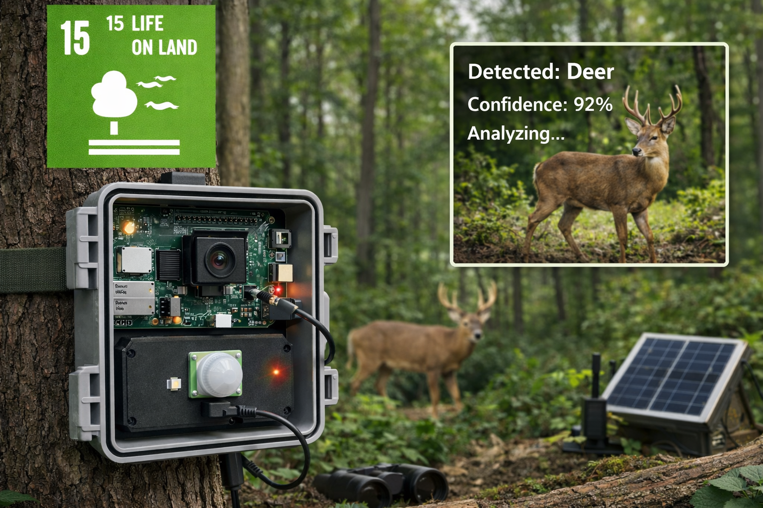
Biodiversity monitoring depends on reliable observation systems. A Raspberry Pi biodiversity camera trap with edge AI can combine motion-triggered imaging, local data storage, metadata logging, and lightweight computer vision models to support ecological observation aligned with SDG 15: Life on Land.
Protecting biodiversity depends on field data. Conservation researchers, land managers, educators, community science groups, restoration teams, and ecological monitoring programs rely on observation systems to understand species presence, habitat use, movement patterns, seasonal activity, restoration outcomes, and environmental change. Without measurement, biodiversity loss often remains difficult to detect until ecosystems are already under significant stress.
This project demonstrates how a Raspberry Pi can function as a smart biodiversity monitoring node that captures wildlife images, stores observations locally, and supports optional computer vision analysis for species classification or observation triage. While simple, the design reflects a broader sustainability principle: ecological resilience improves when biodiversity can be measured clearly, continuously, and responsibly.
The project should not be treated as a certified scientific survey instrument, a conservation compliance system, a replacement for ecological field methods, or an automated species-identification authority. Its purpose is educational and methodological: to show how motion detection, camera capture, metadata, field deployment, edge inference, validation, and ethical data governance can work together in a biodiversity monitoring workflow.
Main Library
Publications
Project Series
Raspberry Pi Projects
Related Topic
Environmental Monitoring
Related Topic
Biosphere Integrity
Related Topic
Land Systems
This project also connects to broader site areas, including Environmental Monitoring Systems, Intelligent Infrastructure Systems, Biosphere Integrity and the Stability of Life Systems, Land-System Change and Ecological Transformation, Climate Change as a Planetary Boundary, Sustainable Development Goals Within Planetary Boundaries, and Planetary Boundaries. In that wider context, this Raspberry Pi camera trap is not only a maker project. It is a small prototype of the ecological sensing, field-data, and edge-computing infrastructure needed for biodiversity monitoring, habitat protection, and conservation decision support.
Abstract
This project presents a prototype Raspberry Pi biodiversity camera trap built around motion-triggered image capture, local file storage, metadata logging, and optional TensorFlow Lite inference. The system responds to PIR motion events, captures wildlife images, stores ecological observations, and can optionally classify images locally using lightweight edge-AI models.
From an engineering perspective, the platform demonstrates a compact autonomous observation system with sensing, capture, local storage, metadata, and optional inference layers. From a sustainability perspective, it illustrates how low-cost embedded systems can expand biodiversity monitoring capacity and support SDG 15: Life on Land through field-ready ecological observation.
The system is intentionally limited. It is not a certified field research instrument, not a formal ecological survey design, not a species-confirmation authority, and not a replacement for ecological expertise. Its value is educational and methodological: it shows how biodiversity monitoring systems can capture field observations while requiring validation, ethical data handling, species-location protection, and human review.
SDG Alignment: Biodiversity, Ecological Infrastructure, Climate Resilience, and Sustainable Communities
This project aligns most directly with SDG 15: Life on Land, which emphasizes the protection, restoration, and sustainable management of terrestrial ecosystems. Biodiversity monitoring supports SDG 15 by making species presence, habitat use, ecological change, and conservation outcomes more observable.
The project also connects to SDG 9: Industry, Innovation and Infrastructure, SDG 13: Climate Action, and SDG 11: Sustainable Cities and Communities. Camera traps support conservation by making wildlife presence, movement, and habitat use visible over time without requiring continuous human presence in the field.
| Sustainable Development Goal | How the Project Relates | Project-Level Mechanism |
|---|---|---|
| SDG 15: Life on Land | Supports biodiversity observation, habitat monitoring, ecological restoration assessment, and conservation data collection. | Motion-triggered wildlife imaging, metadata logging, habitat notes, and optional edge classification. |
| SDG 9: Industry, Innovation and Infrastructure | Demonstrates distributed ecological sensing, low-cost monitoring infrastructure, and edge-computing workflows. | Raspberry Pi node, PIR sensor, camera module, local database, and optional TensorFlow Lite inference. |
| SDG 13: Climate Action | Supports observation of ecosystem response to heat, drought, seasonal change, habitat shifts, and climate stress. | Longitudinal wildlife observations that can be compared with weather, season, restoration, and land-use context. |
| SDG 11: Sustainable Cities and Communities | Relates to urban biodiversity, green corridors, parks, peri-urban habitats, and wildlife-inclusive planning. | Camera-trap observation in community science, education, restoration, and urban ecology contexts. |
The strongest SDG connection is SDG 15. Conservation requires observation. Species decline, habitat fragmentation, corridor disruption, invasive species pressure, restoration outcomes, and changing wildlife activity all become easier to investigate when field observations are structured, timestamped, and connected to habitat metadata.
The connection to SDG 9 comes through ecological monitoring infrastructure. A camera trap is not just a camera; it is a sensing node with power, storage, metadata, image quality, deployment geometry, model inference, and data-governance layers. Low-cost platforms can help expand monitoring capacity where formal ecological infrastructure is limited.
The connection to SDG 13 appears because climate stress affects habitats, flowering and fruiting cycles, water availability, migration timing, breeding conditions, and species distributions. Camera-trap data can help identify ecological responses to changing environmental conditions when paired with weather, land-use, and seasonal context.
The connection to SDG 11 is relevant where camera traps support urban ecology, green-space monitoring, wildlife corridors, parks, riparian buffers, and peri-urban habitat restoration. Cities are not separate from biodiversity; they are increasingly important sites for ecological stewardship.
Because the Sustainable Development Goals are broad public frameworks, it is important not to overclaim. This project is not a complete biodiversity monitoring program, not a formal ecological survey, and not an automated conservation authority. Its contribution is narrower and still meaningful: it teaches the observation architecture behind ecological monitoring.
Connections to Other Site Areas
This Raspberry Pi biodiversity camera trap belongs to a wider body of work on ecological monitoring, intelligent infrastructure, and planetary-boundary risk. It connects directly to Environmental Monitoring Systems, where field sensors, cameras, acoustic devices, remote sensing, and environmental telemetry become tools for understanding ecological change.
It also connects to Intelligent Infrastructure Systems. A biodiversity camera trap becomes more useful when it can sense movement, capture evidence, store observations, classify images, manage metadata, and support dashboards or field review workflows.
At the planetary-boundary level, the project connects most directly to Biosphere Integrity and the Stability of Life Systems. Species presence, abundance, distribution, habitat use, and ecological function are all part of the larger problem of biosphere integrity.
The project also connects to Land-System Change and Ecological Transformation because wildlife activity is shaped by habitat fragmentation, land conversion, corridor loss, agriculture, urban expansion, and restoration efforts. At small scale, a camera trap helps make those land-system effects more visible.
Why Biodiversity Monitoring Matters
Biodiversity is one of the foundational conditions of ecological resilience. Species diversity supports pollination, seed dispersal, soil health, nutrient cycling, water regulation, food systems, pest control, cultural landscapes, and ecosystem stability. Yet biodiversity loss continues globally due to habitat destruction, climate change, pollution, invasive species, overexploitation, and land-use change.
Monitoring systems help researchers answer key ecological questions such as:
- which species are present in a given habitat?
- how frequently do animals use a corridor or landscape?
- how do activity patterns change across seasons?
- how does wildlife respond to habitat fragmentation or restoration?
- how is biodiversity responding to climate stress or human disturbance?
- which areas may require further professional ecological assessment?
Camera traps are especially useful because they allow observation without continuous direct human presence. This reduces disturbance and makes it possible to collect data across long periods, including nighttime, seasonal transitions, migration windows, and periods when human observers are absent.
The strongest value is not just the image. It is the structured observation record: time, site, image, habitat context, detection status, reviewer notes, classification confidence, and uncertainty. A camera trap becomes much more useful when its images are part of a disciplined ecological dataset.
SDG 15 and the Measurement Challenge of Conservation
SDG 15 calls for the protection, restoration, and sustainable use of terrestrial ecosystems. Achieving that goal depends heavily on ecological measurement.
Large conservation organizations and research institutions often use satellite imagery, acoustic sensors, environmental DNA, radio telemetry, camera traps, and field surveys to monitor biodiversity. However, many habitats remain under-observed because high-end monitoring systems can be expensive, labor-intensive, or difficult to deploy at scale.
Low-cost embedded platforms such as Raspberry Pi create opportunities for smaller research teams, community science groups, schools, field labs, and educators to experiment with biodiversity monitoring systems that are affordable, programmable, and adaptable to local conditions.
The strongest use of a prototype like this is not to claim scientific certainty from a single device. Its value is to demonstrate the measurement architecture: motion detection, image capture, metadata logging, field deployment, validation, ethical data governance, human review, and optional classification.
Conservation measurement also requires humility. Camera traps detect what enters the field of view under the right conditions. They do not directly measure all species, abundance, absence, population viability, genetic diversity, or ecosystem function. They are one observation layer within a broader ecological monitoring toolkit.
Camera Traps and Edge AI
Traditional camera traps capture images or short video clips when motion is detected. These systems are effective, but they often generate large numbers of files that must be reviewed manually. Many captures may contain empty frames, wind-blown vegetation, shadows, partial animals, insects, humans, vehicles, domestic animals, or unusable images.
Edge AI changes this workflow by allowing the monitoring device to perform at least some analysis locally. Instead of capturing images alone, the system can begin to answer questions such as:
- was an animal likely present?
- was the image probably empty?
- was the capture high enough quality to prioritize for review?
- can the image be classified into broad species or taxonomic categories?
- should the image be flagged for human verification?
When lightweight machine learning models run on-device, the Raspberry Pi can reduce storage waste, prioritize relevant images, and generate richer ecological datasets. The model must still be validated carefully, especially if the system is used outside the habitat, lighting conditions, camera angle, geography, season, or species context represented in its training data.
Edge AI should support ecological review, not replace it. The safest workflow is often to use models for triage: likely animal, likely empty, low confidence, needs human review. That approach respects uncertainty while still reducing review burden.
System Overview
The Raspberry Pi biodiversity camera trap uses a PIR motion sensor to detect movement, a Raspberry Pi camera module to capture images, local storage to save files, SQLite to preserve observation metadata, and optional TensorFlow Lite inference to classify or prioritize images.
The system can include:
- PIR motion detection
- Raspberry Pi camera capture
- timestamped image storage
- SQLite metadata logging
- optional habitat notes and environmental sensor readings
- optional TensorFlow Lite inference
- optional review workflow or dashboard export
The key design pattern is ecological observation. The device should capture evidence, preserve context, avoid disturbance, and support review. Automation helps reduce manual workload, but it does not eliminate the need for field judgment, ethical deployment, and expert verification when claims matter.
System Requirements
A biodiversity camera trap becomes useful only when its requirements are explicit. The system must trigger reliably, capture usable images, store files safely, preserve metadata, protect sensitive information, and avoid overstating automated classification.
| Requirement | Design Target | Reason |
|---|---|---|
| Motion detection | Detect movement using PIR sensor or similar trigger | Reduces unnecessary captures and allows unattended field observation |
| Image capture | Capture timestamped images when motion is detected | Creates visual evidence for wildlife observation and human review |
| Metadata logging | Store timestamp, filename, site ID, classification, confidence, and notes | Makes images searchable, interpretable, and reusable |
| Local storage | Save images and observation records on device | Allows operation in field conditions without continuous connectivity |
| Optional edge inference | Run local TensorFlow Lite classification or empty-frame filtering | Reduces manual review burden and prioritizes observations |
| Ethical deployment | Protect people, wildlife, habitat, and sensitive species-location data | Prevents monitoring from creating new risks |
| Human review | Preserve uncertain observations and support expert verification | Automated classifiers can misidentify species or miss rare events |
These requirements frame the project as a field-observation system, not simply as a camera script. The system must sense, capture, record, protect, and support interpretation.
System Architecture
A Raspberry Pi biodiversity camera trap integrates several layers.
Sensor Layer
- camera module for image capture
- PIR motion sensor for movement detection
- optional temperature or humidity sensor for habitat context
- optional infrared illumination for low-light observation
Processing Layer
- Raspberry Pi computing platform
- Python control scripts
- optional TensorFlow Lite inference engine
Data Layer
- local image storage
- SQLite metadata database
- optional CSV export
- optional dashboard or cloud synchronization
Typical architecture:
Motion Sensor → Raspberry Pi → Camera Capture → Local Storage → Optional AI Classification → Database / DashboardThis architecture allows the system to operate both as a traditional camera trap and as an edge-AI ecological monitoring node. It also makes the device part of the larger Raspberry Pi environmental monitoring series, where edge computing supports climate sensing, smart irrigation, water quality, renewable energy, early warning, and flood monitoring.
Bill of Materials
- Raspberry Pi 4, Raspberry Pi 5, or Raspberry Pi Zero 2 W
- Raspberry Pi Camera Module
- PIR motion sensor
- microSD card with adequate endurance and storage capacity
- portable battery or solar-assisted power system
- weather-resistant enclosure
- mounting bracket, strap, or field-safe support
- optional infrared lighting for nighttime capture
- optional environmental sensor for habitat temperature and humidity
- optional cellular, LoRa, or Wi-Fi communication module
The Raspberry Pi Zero 2 W is especially attractive for low-power field deployments, while a Raspberry Pi 4 or Raspberry Pi 5 offers more computing power for on-device inference. The best choice depends on whether the goal is long runtime, inference performance, image quality, field ruggedness, or educational simplicity.
For real field deployments, the enclosure, power system, mounting angle, data-retention policy, and ethical permissions are as important as the hardware list.
Engineering Specifications
| Parameter | Reference Design |
|---|---|
| Compute platform | Raspberry Pi 4, Raspberry Pi 5, or Raspberry Pi Zero 2 W |
| Primary trigger sensor | PIR motion sensor |
| Image capture device | Raspberry Pi Camera Module |
| Optional inference | TensorFlow Lite image classification |
| Storage options | Local image files, SQLite metadata logging, optional CSV export |
| Power options | Battery, solar-assisted battery, or fixed supply |
| Deployment mode | Field biodiversity observation node |
| Target scope | Educational, prototype, and experimental conservation monitoring |
The reference design is intentionally modular. It can begin with motion detection and image capture, then expand to metadata logging, habitat context sensors, edge classification, field dashboards, or multi-site monitoring networks.
Measurement Principle: Motion, Images, Metadata, and Ecological Observation
A camera trap does not measure biodiversity directly. It records detection events under particular conditions. Each observation is shaped by sensor placement, detection range, species behavior, body size, temperature contrast, camera angle, vegetation movement, lighting, habitat structure, and the probability that an animal enters the field of view.
The PIR sensor detects changes in infrared radiation associated with movement. When motion is detected, the Raspberry Pi camera captures an image. That image becomes an ecological observation only when paired with metadata: time, location identifier, habitat notes, camera settings, classification, confidence, and review status.
This means a camera trap should be interpreted as a detection system, not a complete census. It can provide evidence of presence, activity patterns, and habitat use, but absence from images does not necessarily mean absence from the landscape.
The measurement principle is therefore: detect motion, capture evidence, preserve metadata, review the observation, classify cautiously, protect sensitive information, and interpret detections within field context.
Mathematical Lens: From Camera-Trap Events to Biodiversity Evidence
The Raspberry Pi biodiversity camera trap can be understood as an event-detection and observation-sampling system. Its output is not simply a folder of images, but a structured record of detections over time.
R = \frac{N_{\mathrm{valid}}}{N_{\mathrm{triggers}}}
\]
Interpretation: Capture success rate \(R\) measures the share of motion triggers that produce usable ecological observations.
A low success rate may indicate poor PIR placement, vegetation motion, lighting artifacts, camera startup delay, or unsuitable mounting geometry.
F = \frac{N_{\mathrm{false}}}{N_{\mathrm{captures}}}
\]
Interpretation: False-trigger rate \(F\) measures the share of captures caused by empty frames, vegetation, shadows, or irrelevant motion.
Tracking false triggers helps improve placement and reduce manual review burden.
A_s = \frac{N_s}{T}
\]
Interpretation: Detection activity \(A_s\) for a species or class \(s\) can be approximated as detections \(N_s\) per deployment time \(T\).
This is not the same as population abundance. It is an activity or detection index that depends on detectability, camera placement, species behavior, and survey design.
P_{\mathrm{review}} =
\begin{cases}
1, & c \geq T_c \ \text{and label is not empty} \\
1, & c < T_c \ \text{and uncertainty is high} \\
0, & label = \text{empty} \ \text{and confidence is high}
\end{cases}
\]
Interpretation: Review priority can combine model confidence \(c\), threshold \(T_c\), predicted label, and uncertainty rules.
The safest ecological workflow often prioritizes both high-confidence animal detections and uncertain cases, while treating high-confidence empty frames as lower priority rather than deleting them automatically.
The mathematical lens shows why the camera trap is more than a trigger-and-capture device. It is a field sampling system that requires detection metrics, review workflows, uncertainty handling, and cautious ecological interpretation.
Connecting the PIR Motion Sensor
The PIR sensor detects motion and triggers image capture when movement is observed in front of the camera.
Typical wiring:
- VCC → Raspberry Pi 5V or compatible supply, depending on sensor model
- GND → Raspberry Pi Ground
- OUT → GPIO 17
This configuration allows the Raspberry Pi to listen for motion events and initiate camera capture only when needed. PIR sensors are sensitive to placement, temperature differences, vegetation motion, sun exposure, and distance from the target area, so field testing is essential.
PIR placement should match the ecological question. A camera aimed at a trail, burrow entrance, water source, restoration corridor, or woodland edge will produce different observations. The placement should be documented so the data is not interpreted as a general description of the whole habitat.
Software Environment and Dependencies
The project uses Python because the Raspberry Pi ecosystem supports GPIO, camera control, image processing, SQLite, TensorFlow Lite, and automation workflows in one environment.
sudo apt update
sudo apt install -y python3-pip python3-venv sqlite3

python3 -m venv .venv
source .venv/bin/activate

pip install RPi.GPIO picamera2 pillow numpy tensorflow
Dependency details may vary by Raspberry Pi OS version, camera stack, and TensorFlow Lite runtime choice. For first testing, begin with motion detection and image capture before installing or running machine learning tools.
For field deployments, camera-trap scripts can later be managed with systemd, cron, or another process supervisor. The system should also include log rotation, storage monitoring, and safe shutdown behavior where possible.
Python Code for Motion Detection
The following Python example listens for PIR motion events using a clear structure that can later be extended into image capture and metadata logging.
"""
Raspberry Pi Biodiversity Camera Trap
PIR Motion Detection Example

Detects motion from a PIR sensor connected to GPIO 17.

Notes:
- PIR sensors can trigger from wildlife, people, moving vegetation,
  sunlight changes, or thermal shifts.
- Field placement affects data quality as much as the code.
"""

import time

import RPi.GPIO as GPIO


PIR_PIN = 17


def setup_gpio() -> None:
    """Configure Raspberry Pi GPIO for PIR motion input."""
    GPIO.setmode(GPIO.BCM)
    GPIO.setup(PIR_PIN, GPIO.IN)


def motion_detected() -> bool:
    """Return True when the PIR sensor output is active."""
    return GPIO.input(PIR_PIN) == GPIO.HIGH


if __name__ == "__main__":
    try:
        setup_gpio()

        print("PIR motion detector started.")

        while True:
            if motion_detected():
                print("Motion detected.")
            else:
                print("No motion.")

            time.sleep(1)

    except KeyboardInterrupt:
        print("Stopping motion detector.")

    finally:
        GPIO.cleanup()
In a full deployment, motion detection would trigger image capture and metadata logging rather than only printing a console event.
Capturing Images with the Raspberry Pi Camera
The following example captures a still image from the Raspberry Pi camera module using picamera2. It creates an output folder and saves each image with a timestamped filename.
"""
Raspberry Pi Camera Capture Example

Captures a still image using Picamera2 and stores it in an images directory.
"""

import time
from datetime import datetime, timezone
from pathlib import Path

from picamera2 import Picamera2


IMAGE_DIR = Path("images")


def initialize_camera() -> Picamera2:
    """Initialize and start the Raspberry Pi camera."""
    camera = Picamera2()
    camera.start()

    # Give the camera time to adjust exposure and white balance.
    time.sleep(2)

    return camera


def timestamped_filename(prefix: str = "wildlife") -> Path:
    """Create a timestamped image filename."""
    IMAGE_DIR.mkdir(parents=True, exist_ok=True)

    timestamp = datetime.now(timezone.utc).strftime("%Y%m%dT%H%M%SZ")
    return IMAGE_DIR / f"{prefix}_{timestamp}.jpg"


def capture_image(camera: Picamera2) -> Path:
    """Capture one image and return the saved file path."""
    filename = timestamped_filename()
    camera.capture_file(str(filename))

    return filename


if __name__ == "__main__":
    picam2 = initialize_camera()

    output_path = capture_image(picam2)
    print(f"Captured image: {output_path}")
In practice, the script can be integrated with the PIR sensor so that wildlife images are captured automatically when motion is detected.
Combining Motion Detection, Image Capture, and Metadata Logging
The following example turns the device into a basic motion-triggered camera trap. It detects motion, captures an image, writes a metadata row to SQLite, and applies a cooldown period to reduce rapid repeat captures.
"""
Motion-Triggered Biodiversity Camera Trap

Combines:
- PIR motion detection
- Raspberry Pi camera capture
- SQLite metadata logging
- cooldown timing to reduce duplicate captures

This is a prototype field-monitoring workflow.
"""

import sqlite3
import time
from datetime import datetime, timezone
from pathlib import Path

import RPi.GPIO as GPIO
from picamera2 import Picamera2


PIR_PIN = 17
IMAGE_DIR = Path("images")
DATABASE_PATH = Path("biodiversity_monitor.db")
CAPTURE_COOLDOWN_SECONDS = 10


def setup_gpio() -> None:
    """Configure GPIO for PIR motion input."""
    GPIO.setmode(GPIO.BCM)
    GPIO.setup(PIR_PIN, GPIO.IN)


def initialize_camera() -> Picamera2:
    """Initialize and start the Raspberry Pi camera."""
    camera = Picamera2()
    camera.start()
    time.sleep(2)
    return camera


def initialize_database() -> sqlite3.Connection:
    """Create SQLite database and observations table if needed."""
    conn = sqlite3.connect(DATABASE_PATH)
    cursor = conn.cursor()

    cursor.execute("""
        CREATE TABLE IF NOT EXISTS observations (
            id INTEGER PRIMARY KEY AUTOINCREMENT,
            timestamp_utc TEXT NOT NULL,
            filename TEXT NOT NULL,
            classification TEXT DEFAULT 'unclassified',
            confidence REAL,
            sensor_id TEXT DEFAULT 'camera_trap_01',
            location_id TEXT DEFAULT 'prototype_habitat'
        )
    """)

    conn.commit()
    return conn


def create_image_path() -> Path:
    """Create a timestamped image path."""
    IMAGE_DIR.mkdir(parents=True, exist_ok=True)

    timestamp = datetime.now(timezone.utc).strftime("%Y%m%dT%H%M%SZ")
    return IMAGE_DIR / f"wildlife_{timestamp}.jpg"


def log_observation(
    conn: sqlite3.Connection,
    filename: str,
    classification: str = "unclassified",
    confidence: float | None = None,
) -> None:
    """Insert one biodiversity observation into SQLite."""
    cursor = conn.cursor()

    cursor.execute("""
        INSERT INTO observations (
            timestamp_utc,
            filename,
            classification,
            confidence
        )
        VALUES (?, ?, ?, ?)
    """, (
        datetime.now(timezone.utc).isoformat(),
        filename,
        classification,
        confidence,
    ))

    conn.commit()


if __name__ == "__main__":
    conn = None

    try:
        setup_gpio()
        camera = initialize_camera()
        conn = initialize_database()

        print("Biodiversity camera trap started.")

        while True:
            if GPIO.input(PIR_PIN) == GPIO.HIGH:
                image_path = create_image_path()
                camera.capture_file(str(image_path))

                log_observation(conn, filename=str(image_path))

                print(f"Motion detected. Captured: {image_path}")

                # Cooldown reduces repeated captures from the same motion event.
                time.sleep(CAPTURE_COOLDOWN_SECONDS)

            time.sleep(0.5)

    except KeyboardInterrupt:
        print("Stopping biodiversity camera trap.")

    finally:
        if conn is not None:
            conn.close()

        GPIO.cleanup()
This combined workflow creates the basic field-monitoring loop: detect, capture, log, and wait. It should be tested indoors before being placed in the field.
Logging Ecological Metadata
Images become far more useful when paired with metadata such as timestamps, locations, broad habitat variables, classification results, review status, and confidence scores. A lightweight SQLite database can store these records.
"""
Ecological Metadata Logger

Stores camera-trap observations in SQLite.

The metadata record can later be joined with image files, classification
results, habitat notes, or environmental sensor readings.
"""

import sqlite3
from datetime import datetime, timezone
from pathlib import Path


DATABASE_PATH = Path("biodiversity_monitor.db")


def create_connection(db_path: Path = DATABASE_PATH) -> sqlite3.Connection:
    """Create and return a SQLite database connection."""
    return sqlite3.connect(db_path)


def initialize_database(conn: sqlite3.Connection) -> None:
    """Create the observations table if it does not already exist."""
    cursor = conn.cursor()

    cursor.execute("""
        CREATE TABLE IF NOT EXISTS observations (
            id INTEGER PRIMARY KEY AUTOINCREMENT,
            timestamp_utc TEXT NOT NULL,
            filename TEXT NOT NULL,
            classification TEXT DEFAULT 'unclassified',
            confidence REAL,
            review_status TEXT DEFAULT 'needs_review',
            habitat_type TEXT,
            sensor_id TEXT DEFAULT 'camera_trap_01',
            location_id TEXT DEFAULT 'prototype_habitat',
            location_precision TEXT DEFAULT 'coarse',
            notes TEXT
        )
    """)

    conn.commit()


def log_observation(
    conn: sqlite3.Connection,
    filename: str,
    classification: str = "unclassified",
    confidence: float | None = None,
    review_status: str = "needs_review",
    habitat_type: str | None = None,
    location_precision: str = "coarse",
    notes: str | None = None,
) -> None:
    """Insert one ecological observation into SQLite."""
    cursor = conn.cursor()

    cursor.execute("""
        INSERT INTO observations (
            timestamp_utc,
            filename,
            classification,
            confidence,
            review_status,
            habitat_type,
            location_precision,
            notes
        )
        VALUES (?, ?, ?, ?, ?, ?, ?, ?)
    """, (
        datetime.now(timezone.utc).isoformat(),
        filename,
        classification,
        confidence,
        review_status,
        habitat_type,
        location_precision,
        notes,
    ))

    conn.commit()


if __name__ == "__main__":
    conn = create_connection()
    initialize_database(conn)

    log_observation(
        conn=conn,
        filename="images/wildlife_20260424T150000Z.jpg",
        classification="unclassified",
        habitat_type="woodland edge",
        location_precision="coarse",
        notes="Prototype test observation."
    )

    conn.close()
This creates a simple biodiversity observation log that can later be reviewed, exported, analyzed, or enriched with classification results. Including review status and location precision helps preserve uncertainty and reduce the risk of exposing sensitive biodiversity data.
Biodiversity Observation Data Model
A camera trap should store observations in a form that supports later review, filtering, quality control, and ethical management. Images alone are not enough.
| Field | Example | Purpose |
|---|---|---|
| timestamp_utc | 2026-05-28T09:15:00Z | Provides a consistent time reference for activity analysis |
| filename | images/wildlife_20260528T091500Z.jpg | Links database record to image file |
| location_id | woodland_edge_03 | Identifies the monitoring site without exposing exact coordinates |
| location_precision | coarse | Controls how sensitive location information is handled |
| habitat_type | riparian corridor | Preserves ecological context |
| classification | mammal | Stores model or reviewer classification |
| confidence | 0.82 | Stores model confidence when inference is used |
| review_status | needs_review | Separates automated output from verified observation |
| quality_flag | valid | Marks empty, blurred, partial, suspect, or valid observations |
| notes | partial animal, low light | Preserves human review context |
A consistent data model turns a file folder into a biodiversity monitoring dataset. It also helps prevent overclaiming, because review status, confidence, and quality flags make uncertainty visible.
Extending the System with Edge AI
Once a camera trap is collecting wildlife images, machine learning can improve its usefulness by reducing manual review time and structuring observation workflows.
Possible edge-AI extensions include:
- filtering empty frames
- detecting animal presence
- classifying images into broad species groups
- prioritizing images for review
- flagging uncertain observations for human verification
- reducing bandwidth needs by syncing only likely-positive captures
Lightweight models such as TensorFlow Lite classifiers can run on Raspberry Pi hardware and provide useful inference without requiring a cloud connection. However, the model must be evaluated against real field images from the target habitat. A classifier trained on one geography, season, camera angle, or lighting condition may perform poorly in another.
The safest implementation treats AI classification as a review aid. Automated labels should be stored with confidence scores and review status, not treated as final species identifications unless validated by appropriate expertise.
Example: TensorFlow Lite Classification Workflow
The following example illustrates the basic structure of local image inference. It loads a TensorFlow Lite model, prepares an image, runs inference, and returns the highest-scoring class.
"""
TensorFlow Lite Wildlife Image Classification Example

Runs local inference on a captured image.

Notes:
- Replace wildlife_model.tflite with a habitat-appropriate model.
- Replace labels.txt with the model's actual labels.
- Validate performance with known local test images before field use.
"""

from pathlib import Path

import numpy as np
from PIL import Image
import tensorflow as tf


MODEL_PATH = Path("models/wildlife_model.tflite")
LABELS_PATH = Path("models/labels.txt")
IMAGE_SIZE = (224, 224)


def load_labels(labels_path: Path = LABELS_PATH) -> list[str]:
    """Load class labels from a text file."""
    return labels_path.read_text().splitlines()


def prepare_image(image_path: Path) -> np.ndarray:
    """
    Load and preprocess image for model inference.

    Many models expect float32 input normalized to 0–1.
    Adjust preprocessing based on the model's requirements.
    """
    image = Image.open(image_path).convert("RGB").resize(IMAGE_SIZE)
    input_data = np.asarray(image, dtype=np.float32) / 255.0
    input_data = np.expand_dims(input_data, axis=0)

    return input_data


def classify_image(image_path: Path) -> dict:
    """Run TensorFlow Lite inference and return the top prediction."""
    labels = load_labels()

    interpreter = tf.lite.Interpreter(model_path=str(MODEL_PATH))
    interpreter.allocate_tensors()

    input_details = interpreter.get_input_details()
    output_details = interpreter.get_output_details()

    input_data = prepare_image(image_path)

    interpreter.set_tensor(input_details[0]["index"], input_data)
    interpreter.invoke()

    output_data = interpreter.get_tensor(output_details[0]["index"])[0]

    top_index = int(np.argmax(output_data))
    confidence = float(output_data[top_index])

    return {
        "classification": labels[top_index] if top_index < len(labels) else "unknown",
        "confidence": confidence,
    }


if __name__ == "__main__":
    result = classify_image(Path("images/wildlife_image.jpg"))
    print(result)
In a real deployment, the model would be trained or selected for ecological image datasets relevant to the habitat, camera placement, and species of interest. Validation should include known local images, difficult lighting conditions, partial animals, empty frames, and likely false triggers.
Filtering Empty Frames and Prioritizing Observations
Camera traps often collect many empty or low-value images. A simple filtering layer can prioritize images for review when the classifier indicates likely animal presence or sufficient confidence.
"""
Observation Filter for Camera-Trap Review

Uses classification and confidence scores to decide whether an image should
be prioritized for human review.
"""


def should_prioritize_observation(
    classification: str,
    confidence: float,
    confidence_threshold: float = 0.70,
) -> bool:
    """
    Return True if an observation should be prioritized.

    A real workflow should keep uncertain ecological observations available
    for review rather than deleting them automatically.
    """
    empty_labels = {"empty", "no_animal", "blank", "vegetation"}

    if classification.lower() in empty_labels:
        return False

    return confidence >= confidence_threshold


if __name__ == "__main__":
    example_classification = "mammal"
    example_confidence = 0.82

    if should_prioritize_observation(example_classification, example_confidence):
        print("Prioritize this image for review.")
    else:
        print("Lower priority observation.")
For conservation use, the safest workflow is usually to mark low-priority images rather than delete them automatically. Rare species, partial captures, nocturnal images, and difficult lighting conditions can be misclassified by simple models.
GitHub Repository
The article body includes the core motion-detection, image-capture, metadata, and edge-AI workflow examples so the build remains readable. The full repository expands the project into a reproducible prototype package, including Python motion-detection scripts, camera capture workflows, SQLite metadata logging, TensorFlow Lite inference examples, deployment notes, and example biodiversity observation datasets.
Complete Code Repository
The full code distribution for this project, including Python motion-detection scripts, camera capture workflows, SQLite metadata logging, TensorFlow Lite inference examples, deployment notes, and example biodiversity observation datasets, is available on GitHub.
The repository contains the complete prototype build materials:
- Python motion-detection scripts
- camera capture code
- metadata logging examples
- TensorFlow Lite inference examples
- deployment notes
- example biodiversity datasets
Repository Structure
raspberry-pi-biodiversity-camera-trap-edge-ai/

README.md
LICENSE
requirements.txt

src/
  detect_motion.py
  capture_image.py
  capture_and_log.py
  classify_image_tflite.py
  log_observation.py
  filter_observations.py

docs/
  setup_guide.md
  deployment_notes.md
  sensor_notes.md
  camera_notes.md
  model_notes.md
  ethics_and_data_governance.md

data/
  example_biodiversity_observations.csv

hardware/
Engineers can clone the repository, fork the design, or download the complete project using GitHub’s Download ZIP feature. All materials are released under the MIT License to support reuse in research, education, conservation prototyping, and ecological monitoring projects.
Computer Vision and Ecological Research
Computer vision is becoming increasingly important in biodiversity science. Large ecological datasets are difficult to analyze manually, especially when camera traps operate continuously over weeks or months.
Edge AI can help by reducing manual review time and making monitoring systems more scalable. Even simple models that separate “animal present” from “empty frame” can significantly improve efficiency.
More advanced systems may eventually support:
- species classification
- behavioral detection
- habitat-use analysis
- movement corridor monitoring
- automated biodiversity indexing
- change detection across seasons and restoration sites
However, ecological image classification remains a domain where human verification is still important. Models can misclassify species, overfit to training conditions, fail under low light, or confuse similar animals. A transparent workflow should record model confidence and preserve human review pathways.
The ethical standard should be higher when the consequences are higher. Misclassifying a common species in a classroom dataset is one kind of error. Publishing the location of an endangered species, misreporting a sensitive detection, or ignoring uncertainty in conservation decisions is a much more serious problem.
Ethical Field Deployment and Sensitive Biodiversity Data
Biodiversity monitoring requires ethical field practice. Camera traps can unintentionally capture people, private property, sensitive species locations, culturally significant places, or ecologically vulnerable activity. Field deployment should therefore consider privacy, permits, land access, wildlife disturbance, and data governance.
Important ethical considerations include:
- obtain permission before deploying devices on public, private, protected, or Indigenous-managed lands
- avoid placing cameras where people reasonably expect privacy
- avoid disturbing nests, dens, breeding sites, water sources, or sensitive habitats
- avoid publishing exact locations of endangered, poaching-vulnerable, or disturbance-sensitive species
- secure stored images and metadata when they contain sensitive ecological information
- blur, delete, restrict, or otherwise govern incidental human images according to ethical and legal requirements
- follow institutional, legal, and conservation guidelines for field research
- include human review before making public claims about sensitive species observations
A camera trap can strengthen ecological visibility, but it should not create new risks for wildlife, people, or sensitive habitats. In conservation settings, location privacy is often part of species protection.
For public datasets, consider generalizing location IDs, withholding coordinates, delaying publication, or restricting sensitive records. A useful biodiversity monitoring system should protect the living systems it observes.
Power, Deployment, and Field Design
Real-world biodiversity monitoring systems must operate reliably outdoors. That means power management, enclosure design, mounting geometry, and storage capacity matter as much as code.
Typical field considerations include:
- battery life
- weather resistance
- camera mounting angle
- PIR detection range and sensitivity
- nighttime visibility and infrared illumination
- storage capacity for images and metadata
- temperature and moisture exposure
- animal interference, insects, vegetation, dust, and mud
- safe mounting that avoids damaging trees, structures, or habitat
- retrieval plan and maintenance schedule
Solar-assisted power systems can make longer deployments possible, while careful enclosure design protects the device without interfering with the camera’s field of view or the PIR sensor’s motion detection.
Power design should match the deployment strategy. Continuous inference, frequent image capture, wireless communication, and nighttime illumination can drain batteries quickly. A low-power workflow that captures, logs, and sleeps may be more appropriate for long deployments than always-on processing.
Biodiversity Monitoring and Climate Resilience
Biodiversity monitoring is not only about counting species. It is also about understanding how ecosystems respond to environmental change.
Camera trap systems can help reveal how wildlife activity shifts in response to:
- habitat fragmentation
- climate stress
- human land-use change
- seasonal environmental variability
- restoration interventions
- urban expansion and corridor disruption
- drought, heat, fire, flood, or altered food availability
In that sense, biodiversity monitoring supports not only SDG 15: Life on Land but also broader resilience strategies that depend on understanding ecological conditions over time. It also connects directly to the planetary-boundary concern of biosphere integrity, where the loss of species, genetic diversity, and ecological function can destabilize life-support systems.
Climate resilience should not be reduced to infrastructure alone. Ecological resilience matters too. Wildlife movement, habitat connectivity, seasonal patterns, and species interactions are part of the living infrastructure that helps landscapes adapt or fail under stress.
Engineering Notes
A few technical considerations are especially important in this build:
- False triggers: PIR-based systems can capture irrelevant motion if placement is poor.
- Storage management: image-heavy workflows require disciplined file naming, metadata handling, and retention policies.
- Power budget: camera, storage, wireless communication, and inference workloads increase energy demand significantly.
- Model realism: useful classification depends on habitat-relevant training data and careful validation.
- Field reliability: deployment success depends on enclosure quality, mounting stability, and environmental hardening.
- Ethical data handling: sensitive species locations and incidental human images require careful governance.
- Human review: automated classification should support ecological interpretation, not replace expert judgment.
- Sampling design: one camera’s detections should not be mistaken for full habitat-level biodiversity.
These issues make the project more than a software workflow. It is a field engineering system for ecological observation.
Deployment Scope and Data-Quality Considerations
This prototype is designed for educational, experimental, and early-stage biodiversity monitoring. It should not be treated as a certified field research instrument, conservation compliance system, or substitute for formal ecological survey design.
Data quality depends on camera placement, motion-trigger sensitivity, species behavior, lighting conditions, vegetation movement, weather, image quality, seasonal timing, and model validity. A camera trap may miss animals outside its field of view, over-detect moving vegetation, under-detect small or cold-bodied animals, or collect biased observations based on placement.
These limitations do not make the system unhelpful. They define the appropriate scope of use: local observation, prototype field data collection, education, community science, ecological experimentation, and conservation technology development.
Responsible interpretation requires distinguishing between detection and absence. A species detected on camera was present in front of the device at that time. A species not detected may still be present elsewhere, active at different times, outside the camera’s view, too small for detection, or missed because of placement and sensor limits.
Failure Modes and Practical Risks
A useful biodiversity monitoring article should explain not only how the system works, but how it can fail. Field monitoring systems often fail through placement error, power limits, storage limits, sensor misfires, model mismatch, and overinterpretation.
- False triggers: vegetation, shadows, rain, insects, or sunlight shifts may trigger captures without wildlife.
- Missed detections: animals outside the PIR range, moving too quickly, too slowly, or outside the camera angle may be missed.
- Image blur: low light, movement, or poor camera settings may make images difficult to classify.
- Storage exhaustion: frequent captures can fill the microSD card and stop data collection.
- Battery failure: power loss can end deployment before the intended monitoring period.
- Moisture intrusion: rain, condensation, or humidity can damage electronics or blur the lens.
- Model mismatch: a classifier may perform poorly outside its training habitat, geography, or lighting conditions.
- Sensitive data exposure: exact species locations or incidental human images can create ethical and legal risks.
- Overinterpretation: camera-trap detections can be mistaken for abundance, absence, or population trends without proper design.
- Disturbance risk: careless installation near nests, dens, or sensitive habitats may harm the wildlife being observed.
These risks do not make the project unusable. They make ethical deployment, field validation, storage planning, and human review essential. A monitoring system should protect both data quality and the ecological subjects it observes.
Validation and Testing
To bring this project closer to engineering-grade documentation, validation should include:
- verify PIR triggering under controlled movement conditions
- confirm that the camera captures images reliably after motion events
- test file naming and storage behavior across repeated captures
- validate SQLite metadata logging if used
- check TensorFlow Lite inference outputs against known test images
- evaluate battery/runtime behavior under realistic capture frequency
- test enclosure performance under expected field conditions
- review images manually to estimate false triggers and missed detections
- test the system in daylight, low light, rain risk, wind, and vegetation-motion conditions
- document camera angle, height, distance to target zone, and habitat type
If the system behaves inconsistently, the issue may be related to PIR placement, lighting, camera initialization, storage throughput, model mismatch, or power stability rather than to the ecological monitoring concept itself.
Example Validation Record
| Test | Expected Result | Observed Result | Likely Issue | Action |
|---|---|---|---|---|
| PIR trigger test | Motion triggers consistently at target distance | Triggers only at close range | Sensor angle or sensitivity | Adjust mounting and retest |
| Image capture test | Image saved after each trigger | Occasional missing file | Camera startup or storage delay | Add delay and check storage speed |
| False trigger test | Low empty-frame rate | High vegetation-trigger rate | Camera aimed at moving grass | Change angle or clear field of view ethically |
| Inference test | Known local images classified plausibly | Common species mislabeled | Model not habitat appropriate | Use local validation set and human review |
| Weather test | No moisture intrusion | Condensation visible | Enclosure sealing or venting issue | Improve enclosure and desiccant strategy |
Validation records like this help distinguish ecological signal from system artifact. That distinction is essential in field monitoring.
Suggested Performance Metrics
For a more rigorous evaluation, the platform can be assessed using several simple metrics:
- trigger reliability: whether motion events consistently produce captures
- capture success rate: percentage of valid images per trigger event
- false trigger rate: percentage of captures caused by vegetation, lighting changes, or irrelevant motion
- storage reliability: whether images and metadata are preserved without corruption
- classification usefulness: whether inference helps reduce manual review workload
- field endurance: how long the system operates under realistic deployment conditions
- review efficiency: how much the system reduces time required to find ecologically useful observations
- ethical compliance: whether deployment avoids privacy violations, disturbance, and sensitive location exposure
- metadata completeness: whether observations include timestamps, site IDs, habitat notes, and review status
Even simple tracking of these metrics improves the project’s value as an experimental biodiversity monitoring platform. A camera trap should be evaluated not only by how many images it captures, but by how many useful, ethical, interpretable observations it produces.
Field Maintenance and Data Review Workflow
Field camera traps require a disciplined maintenance and review workflow. A device may appear to be operating while the battery is low, the lens is fogged, the PIR sensor is poorly aligned, the storage card is nearly full, or vegetation has moved into the frame.
A practical maintenance workflow should include:
- inspect enclosure seal, lens clarity, and mounting stability
- check battery voltage or remaining charge
- verify storage capacity and image write behavior
- review a sample of recent captures for focus, angle, and false triggers
- record field notes after every visit
- avoid excessive disturbance around the monitoring location
- update metadata if the camera is moved, tilted, cleaned, or adjusted
- protect sensitive images and location data during transfer
A review workflow should also distinguish model output from verified observation. A useful record might include “model label,” “model confidence,” “human review status,” and “verified classification.” This creates a transparent chain from capture to interpretation.
The Future of Biodiversity Monitoring
Ecological monitoring is increasingly combining:
- camera traps
- acoustic sensors
- satellite imagery
- environmental DNA
- machine learning models
- distributed environmental data systems
- open biodiversity databases
- community science networks
Platforms such as Raspberry Pi make it possible for researchers, students, educators, conservation innovators, and community organizations to prototype these systems at relatively low cost. Projects like this demonstrate how accessible computing technologies can support more scalable and intelligent biodiversity observation systems.
The long-term challenge is not merely collecting more wildlife images. It is building biodiversity monitoring systems that are accurate enough to be useful, transparent enough to be trusted, ethical enough to protect sensitive species and communities, and accessible enough to support conservation where monitoring capacity is limited.
The future of biodiversity monitoring should also remain plural. Camera traps are powerful, but they should be combined with field ecology, local knowledge, acoustic monitoring, habitat assessment, remote sensing, eDNA, and community stewardship rather than treated as the whole of biodiversity science.
Responsible Deployment
This prototype is appropriate for classrooms, makerspaces, conservation education, restoration projects, ecological technology labs, supervised community science, and early-stage biodiversity monitoring experiments. It should not be used for sensitive species monitoring, protected-land research, Indigenous-managed land, or public deployment without appropriate permission, ethical review, and data-governance planning.
Responsible deployment means matching the system to the consequence of error. A classroom demonstration can use simulated movement and test images. A backyard biodiversity project requires privacy awareness and non-disturbance. A conservation field study requires permissions, careful siting, sensitive-data rules, validation, and human review.
A responsible version should include location-privacy controls, clear data-retention rules, human review of sensitive detections, careful handling of incidental human images, explicit uncertainty language for AI output, and a plan for removing the device safely at the end of deployment.
The central rule is simple: biodiversity monitoring should protect the life it makes visible.
Reproducibility
All code, documentation, and supporting build materials necessary to reproduce the prototype are included in the project repository. The design intentionally relies on widely available Raspberry Pi hardware, open-source Python libraries, and common field components so that it can be rebuilt in classrooms, labs, makerspaces, community science programs, and independent biodiversity monitoring projects.
The system is intended as a reference implementation rather than a certified field research instrument. Engineers adapting it for long-term deployment should validate enclosure resilience, power systems, image storage workflows, sensor placement, model behavior, ethical data handling, and habitat-specific performance under real operating conditions.
For the rest of this project series, reproducibility should mean more than making code available. Each article should include a clear bill of materials, setup instructions, validation notes, data model, known failure modes, test procedure, responsible-use framing, and realistic statement of appropriate scope.
Conclusion
Building a Raspberry Pi biodiversity camera trap with edge AI demonstrates how embedded systems and local inference can support ecological observation. By combining motion-triggered capture, metadata logging, local storage, and optional on-device classification, the system creates a flexible platform for conservation-oriented monitoring.
Although compact, the design reflects a broader sustainability principle: ecosystem protection depends on ecological visibility. When biodiversity can be measured clearly and continuously, conservation strategies become more informed and more responsive.
For classrooms, makerspaces, conservation labs, restoration projects, community science programs, and early-stage ecological monitoring work, this Raspberry Pi biodiversity camera trap provides a practical foundation for understanding how sensing, field data, edge AI, and biodiversity protection can work together.
The deeper lesson is not simply that a Raspberry Pi can capture wildlife images. The deeper lesson is that biodiversity monitoring requires an ethical observation system: careful placement, metadata, validation, human review, location privacy, uncertainty handling, and respect for the living systems being studied. When those layers are treated seriously, even a small prototype can demonstrate the logic of more responsible ecological monitoring infrastructure.
Related Articles and Site Areas
- Raspberry Pi Sustainability Engineering Series
- Smart Irrigation with Raspberry Pi
- Raspberry Pi Water Quality Monitoring System
- Environmental Monitoring Systems
- Intelligent Infrastructure Systems
- Biosphere Integrity and the Stability of Life Systems
- Land-System Change and Ecological Transformation
- Climate Change as a Planetary Boundary
- Sustainable Development Goals Within Planetary Boundaries
- Planetary Boundaries
Further Reading
- Convention on Biological Diversity (n.d.) Convention on Biological Diversity. Available at: https://www.cbd.int/
- GBIF (n.d.) Global Biodiversity Information Facility. Available at: https://www.gbif.org/
- IPBES (2019) Global Assessment Report on Biodiversity and Ecosystem Services. Available at: https://ipbes.net/global-assessment
- Raspberry Pi Foundation (n.d.) Camera Software. Available at: https://www.raspberrypi.com/documentation/computers/camera_software.html
- Raspberry Pi Foundation (n.d.) Raspberry Pi Documentation. Available at: https://www.raspberrypi.com/documentation/
- TensorFlow (n.d.) TensorFlow Lite. Available at: https://www.tensorflow.org/lite
- United Nations (n.d.) Sustainable Development Goal 15: Life on Land. Available at: https://sdgs.un.org/goals/goal15
- Wildlife Insights (n.d.) Wildlife Insights. Available at: https://www.wildlifeinsights.org/
- World Conservation Monitoring Centre (n.d.) UNEP-WCMC. Available at: https://www.unep-wcmc.org/
References
- Convention on Biological Diversity (n.d.) Convention on Biological Diversity. Available at: https://www.cbd.int/
- GBIF (n.d.) Global Biodiversity Information Facility. Available at: https://www.gbif.org/
- IPBES (2019) Global Assessment Report on Biodiversity and Ecosystem Services. Available at: https://ipbes.net/global-assessment
- Raspberry Pi Foundation (n.d.) Camera Software. Available at: https://www.raspberrypi.com/documentation/computers/camera_software.html
- Raspberry Pi Foundation (n.d.) Raspberry Pi Documentation. Available at: https://www.raspberrypi.com/documentation/
- TensorFlow (n.d.) TensorFlow Lite. Available at: https://www.tensorflow.org/lite
- United Nations (n.d.) The 17 Sustainable Development Goals. Available at: https://sdgs.un.org/goals
- United Nations (n.d.) Sustainable Development Goal 9: Industry, Innovation and Infrastructure. Available at: https://sdgs.un.org/goals/goal9
- United Nations (n.d.) Sustainable Development Goal 11: Sustainable Cities and Communities. Available at: https://sdgs.un.org/goals/goal11
- United Nations (n.d.) Sustainable Development Goal 13: Climate Action. Available at: https://sdgs.un.org/goals/goal13
- United Nations (n.d.) Sustainable Development Goal 15: Life on Land. Available at: https://sdgs.un.org/goals/goal15
- Wildlife Insights (n.d.) Wildlife Insights. Available at: https://www.wildlifeinsights.org/
- World Conservation Monitoring Centre (n.d.) UNEP-WCMC. Available at: https://www.unep-wcmc.org/