
Last Updated May 14, 2026
Environmental sensor networks are infrastructures of distributed environmental observability through which heterogeneous, dynamic, and only partially measurable environments become sufficiently visible for science, operations, regulation, and governance. They connect sensing nodes, telemetry systems, metadata standards, quality-control routines, analytical platforms, and decision workflows in order to transform scattered measurements into environmental intelligence across space and time. In this sense, an environmental sensor network is not merely a collection of instruments deployed in multiple places. It is a socio-technical system for producing selective environmental visibility: a structured way of deciding what will be measured, where, how often, with what confidence, and for what institutional purpose.
Environmental systems pose a distinctive observational challenge because they are spatially uneven, temporally variable, and causally layered. River systems branch, atmospheres stratify, coastlines oscillate, soils vary through depth and texture, ecosystems respond across different biological timescales, and urban environments channel pollutants and heat through infrastructure and land use. No single node captures an environment in full. Even dense networks rely on indirect variables, incomplete coverage, and inferential models. Environmental sensor networks therefore do not eliminate uncertainty. They reorganize it. They make some parts of the environment more visible than others, some processes more measurable than others, and some risks more governable than others.
The deeper significance of environmental sensor networks lies in the fact that they blur the boundary between observation and intervention. When sensing becomes persistent, telemetry becomes reliable, and analytics become operationally integrated, environmental conditions can be acted upon more quickly and sometimes preemptively. This creates new possibilities for early warning, adaptive management, compliance, infrastructure operations, public reporting, and resilience planning. But it also raises harder questions. What exactly is the network observing: a direct variable, a proxy, or a modeled state? What parts of the environment remain outside its topology? When does more data create better judgment, and when does it simply create dashboards that exceed institutional capacity to respond?
Main Library
Publications
Article Map
Environmental Monitoring
Related Topic
Data Systems
Related Topic
Embedded & Edge
Related Topic
Infrastructure Systems
Environmental sensor networks are where field observation becomes networked evidence infrastructure. They coordinate distributed nodes, communications links, metadata, quality-control logic, data platforms, models, dashboards, alerts, and governance workflows so that environmental conditions can be interpreted across space and time. Yet a sensor network is only as strong as the chain that connects node placement, measurement quality, telemetry, validation, interoperability, inference, and institutional response. The central question is not simply how many sensors exist, but whether the network produces a defensible view of the environmental process it claims to represent.
Engineering Problem
The engineering problem is how to design environmental sensor networks that can observe distributed environmental processes with enough coverage, temporal continuity, metadata coherence, calibration discipline, telemetry reliability, quality control, and institutional fit to support defensible environmental inference. A sensor network is not made reliable simply by adding nodes. Node placement, sampling cadence, observed variables, power, communications, local storage, metadata, calibration, data standards, validation workflows, and response pathways all determine whether distributed measurement becomes meaningful environmental intelligence.
This problem is difficult because environmental processes are spatially structured and unevenly observable. A river network may have ungauged tributaries, poorly monitored headwaters, urban stormwater pulses, and main-stem stations that provide incomplete information about upstream sources. An air-quality network may capture regional conditions while missing street-level exposure gradients, industrial fence-line patterns, or indoor-outdoor differences. A coastal network may observe offshore buoys while underrepresenting estuarine transition zones. A soil network may capture surface moisture but miss depth-dependent root-zone dynamics. An ecological network may monitor accessible habitat while overlooking marginalized landscapes, low-capacity regions, or less visible species groups.
Weak sensor networks treat distributed devices as if they automatically produce distributed understanding. Strong networks treat topology, metadata, calibration, validation, telemetry, and governance as part of the evidence architecture. They ask what process is being observed, what spatial and temporal scales matter, where blind spots remain, which variables are proxies, what uncertainty is acceptable, how quality flags are assigned, how standards preserve meaning, and whether the institutions receiving the data can actually respond. The network succeeds only when distributed measurement is matched to environmental process and decision use.
| Engineering Tension | Why It Matters | Required Evidence |
|---|---|---|
| Coverage versus representativeness | More nodes do not guarantee that the network captures the relevant gradients, hotspots, or vulnerable places. | Topology plan, site-selection rationale, representativeness assessment, gap map |
| Density versus maintainability | Dense networks can improve visibility while multiplying calibration, service, power, and data-quality burdens. | Maintenance plan, device registry, calibration schedule, service capacity estimate |
| Timeliness versus validation depth | Near-real-time data may be operationally useful before full QA/QC review is complete. | Latency class, preliminary flag, QC status, alert confidence, review pathway |
| Interoperability versus local specificity | Common formats help integration, but local context and domain-specific meaning must not be erased. | Metadata schema, observed-property registry, unit registry, site-context fields |
| Proxy measurement versus direct inference | Networks often measure indicators that stand in for broader environmental processes. | Proxy rationale, calibration relationship, validity limits, uncertainty note |
| Automation versus accountability | Thresholds, dashboards, and alerts can accelerate response while obscuring assumptions and blind spots. | Alert-rule registry, action pathway, model card, public evidence package |
| Visibility versus governability | Seeing conditions earlier does not guarantee institutions can act. | Decision-use statement, escalation policy, response capacity, governance log |
The practical question is therefore: can the network make the right parts of the environment visible at the right resolution, with the right quality controls, in time for the right decisions?
Reference Architecture
A practical environmental sensor network architecture can be understood as a distributed evidence system. The exact implementation may include low-power field nodes, rugged embedded devices, telemetry gateways, satellite or cellular links, time-series platforms, OGC SensorThings-style APIs, metadata catalogs, QARTOD-style quality checks, geospatial services, dashboards, alert engines, governance logs, and public reporting workflows. The responsibilities remain consistent: observe, locate, timestamp, transmit, validate, harmonize, analyze, alert, interpret, decide, and learn.
| Layer | Engineering Role | Primary Risk | Evidence Artifact |
|---|---|---|---|
| Network objective layer | Defines the environmental process, monitored variables, spatial scale, temporal scale, decision use, and evidence standard. | Network optimized for device deployment rather than environmental question. | Network objective manifest, decision-use statement, monitoring design rationale |
| Topology and site-selection layer | Determines node placement, density, redundancy, reference sites, hotspots, gradients, vertical layers, and blind-spot strategy. | Coverage appears broad while key gradients or vulnerable areas remain unobserved. | Topology plan, site registry, coverage map, gap analysis |
| Sensing-node layer | Collects environmental observations through fixed, mobile, semi-mobile, or hybrid field nodes. | Sensor drift, fouling, local failure, poor siting, or untracked device state. | Device registry, calibration log, field deployment record, health telemetry |
| Telemetry and transport layer | Moves observations from field nodes to local, regional, cloud, or national data environments. | Packet loss, delayed data, stale streams, missing acknowledgments, hidden gaps. | Connectivity manifest, delivery log, latency report, delayed-record flag |
| Metadata and semantic layer | Preserves device identity, location, time, observed property, unit, method, calibration, quality, and provenance. | Data arrive technically but lose interpretive context. | Metadata schema, observed-property registry, unit registry, SensorThings-style model |
| Quality-control and validation layer | Applies range, spike, flatline, drift, missing-data, cross-node, calibration, and domain checks. | Continuous data create an illusion of precision while quality quietly degrades. | QC policy, validation report, quality flags, suspect-data log |
| Data platform and integration layer | Stores, harmonizes, exposes, catalogs, and integrates distributed observations across nodes and platforms. | Fragmented silos prevent network-scale interpretation. | Data catalog, API documentation, ingestion log, lineage record |
| Analytics and alert layer | Transforms observations into thresholds, maps, trends, forecasts, anomalies, exposures, or decision-support outputs. | Models or dashboards exceed evidence quality or institutional capacity. | Alert-rule registry, model card, dashboard specification, review log |
| Governance and accountability layer | Connects network outputs to operations, science, regulation, public communication, maintenance, and corrective learning. | Network visibility does not translate into legitimate or effective response. | Governance register, escalation policy, public evidence package, maintenance record |
This architecture makes clear that environmental sensor networks are not only technical networks. They are observing systems whose credibility depends on the coherence of topology, measurement, metadata, quality control, interoperability, analytics, and governance.
Implementation Pattern
A rigorous environmental sensor network implementation begins with the environmental process and the decision need, not with the number of available devices. The correct network design depends on whether the system is intended to detect thresholds, characterize long-term trend, support public alerts, identify hotspots, estimate flux, protect human exposure, monitor ecological condition, guide maintenance, support compliance, or evaluate restoration and sustainability interventions. Each purpose implies different topology, redundancy, sampling cadence, telemetry, QA/QC, metadata, and action requirements.
| Artifact | Purpose | Suggested Format |
|---|---|---|
| Network objective manifest | Defines environmental process, monitored variables, spatial scale, temporal scale, decision uses, and evidence standards. | YAML, Markdown, architecture decision record |
| Node and site registry | Lists nodes, locations, sensors, observed properties, units, calibration status, ownership, and deployment context. | CSV, SQL table, GIS layer |
| Topology and coverage plan | Documents node placement, gradients, redundancy, reference sites, hotspots, vertical structure, and blind spots. | GeoJSON, map layer, Markdown design note |
| Telemetry and latency manifest | Defines transport modes, expected delivery, retry policy, latency classes, and delayed-record handling. | YAML, network design record |
| Metadata and observation schema | Defines required fields for node identity, location, observed property, unit, time, calibration, quality, and provenance. | JSON Schema, SQL schema, SensorThings-style model |
| Network QA/QC policy | Defines node-level, cross-node, temporal, spatial, calibration, drift, and missing-data checks. | YAML, QARTOD-style rules, validation code |
| Alert and action registry | Documents thresholds, anomaly rules, severity, owners, suppression, escalation, and response pathways. | CSV, YAML, alerting platform configuration |
| Coverage and equity audit | Assesses whether network visibility is uneven across communities, habitats, jurisdictions, or risk zones. | Map, tabular audit, governance memo |
| Network observability dashboard | Tracks node health, telemetry, data completeness, calibration, QC failure rates, latency, and alert burden. | Dashboard, metrics specification, status API |
| Governance and evidence log | Records topology changes, node replacements, calibration decisions, public caveats, and review outcomes. | CSV, SQL table, governance register |
The implementation goal is to make the network inspectable. Users should be able to trace a dashboard, alert, compliance claim, exposure estimate, or ecological trend back to node placement, measurement method, metadata, quality flags, calibration status, telemetry history, and decision context.
Research-Grade Framing: Sensor Networks as Infrastructures of Selective Visibility
A research-grade account of environmental sensor networks begins with a simple but deep fact: environments are not fully observable. Networks do not render them transparent. They render them selectively visible. This selectivity is shaped by the variables chosen, the topology of deployment, the frequency of measurement, the sensitivity and limits of instruments, the standards used to describe observations, the validation routines used to assign confidence, and the models through which measurements are interpreted.
This means sensor networks are not neutral mirrors of environmental reality. They privilege what is measurable, fundable, standardizable, instrumentable, and operationally actionable. A network optimized for flood warning produces one kind of environmental truth. A network optimized for regulatory compliance produces another. A network designed around infrastructure reliability may be weak on ecological representativeness. A network designed for long-term trend may underperform for fast anomaly detection. Environmental sensor networks therefore do more than observe. They shape what kinds of environmental change become institutionally real.
Selective visibility is not a flaw to be eradicated; it is a design condition to be acknowledged. The question is whether a network’s partial view is matched well enough to the processes, risks, and decisions it is meant to support. Exceptional network design begins by recognizing that every observing system is a theory of what matters, where it matters, how often it must be observed, and how much of it must be seen to justify action.
| Limited Pattern | Stronger Pattern | Why the Shift Matters |
|---|---|---|
| Add more sensors | Design topology around environmental process, risk, representativeness, and decision use | Prevents node count from being mistaken for coverage quality. |
| Transmit more data | Preserve metadata, quality flags, calibration, latency status, and provenance | Prevents telemetry from becoming decontextualized measurement. |
| Create dashboards | Connect visual outputs to evidence quality, thresholds, uncertainty, and action pathways | Prevents display abundance from becoming operational confusion. |
| Standardize formats | Combine interoperability with local context, field meaning, and proxy limits | Prevents semantic simplification from erasing environmental complexity. |
| Automate alerts | Govern alert thresholds, severity, owners, false positives, and institutional capacity | Prevents early warning from becoming alert fatigue. |
| Use the network as evidence | Make evidence traceable from claim to node, method, calibration, QA/QC, and blind spots | Protects public, regulatory, scientific, and operational accountability. |
The central research question is not “How many environmental sensors can be connected?” but “What kind of environmental visibility does the network produce, for whom, with what limits, and with what consequences for action?”
Formal Model: Coverage, Completeness, Representativeness, and Network Evidence Quality
A useful formal model separates spatial coverage, temporal completeness, node availability, representativeness, data quality, interoperability, latency, and action fit. Let \(C_s\) represent spatial coverage, \(C_t\) temporal completeness, \(A_n\) node availability, \(R_p\) representativeness, \(Q_d\) data quality, \(I_m\) interoperability maturity, \(L_r\) latency readiness, and \(F_a\) action fit. Network evidence quality depends on how these dimensions work together, not simply on sensor count.
C_{\mathrm{spatial}} = \frac{A_{\mathrm{monitored}}}{A_{\mathrm{target}}}
\]
Interpretation: Spatial coverage measures the share of the target area, corridor, watershed, habitat, or risk zone represented by the network.
C_{\mathrm{temporal}} = \frac{N_{\mathrm{valid\ time\ steps}}}{N_{\mathrm{expected\ time\ steps}}}
\]
Interpretation: Temporal completeness measures whether the network captures the expected sequence of observations without major gaps.
A_{\mathrm{network}} = \frac{N_{\mathrm{active\ nodes}}}{N_{\mathrm{deployed\ nodes}}}
\]
Interpretation: Network availability measures how many deployed nodes are operating in valid measurement state.
R_{\mathrm{representativeness}} = 1 – \frac{G_{\mathrm{unobserved}}}{G_{\mathrm{target}}}
\]
Interpretation: Representativeness can be approximated as the share of target gradients, habitats, risk zones, or populations that are meaningfully observed.
L_{\mathrm{readiness}} = 1 – \min\left(\frac{L_{\mathrm{observed}}}{L_{\mathrm{target}}}, 1\right)
\]
Interpretation: Latency readiness is higher when network data arrive within the time horizon required for decision use.
Q_{\mathrm{network\ evidence}} = w_1C_{\mathrm{spatial}} + w_2C_{\mathrm{temporal}} + w_3A_{\mathrm{network}} + w_4R_{\mathrm{representativeness}} + w_5Q_{\mathrm{data}} + w_6I_{\mathrm{metadata}} + w_7L_{\mathrm{readiness}} + w_8F_{\mathrm{action}}
\]
Interpretation: Network evidence quality depends on spatial coverage, temporal completeness, node availability, representativeness, data quality, metadata/interoperability maturity, latency readiness, and action fit.
This formal structure protects against a common error in environmental monitoring: equating sensor density with evidence quality. A dense network can still be weak if it misses key gradients, lacks calibration discipline, loses metadata, has poor telemetry, or produces signals that institutions cannot act upon.
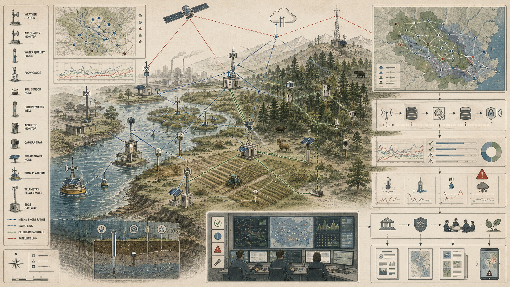
What Are Environmental Sensor Networks?
Environmental sensor networks are coordinated systems of distributed sensing nodes used to observe environmental variables repeatedly and at scale. These nodes may measure atmospheric, hydrological, oceanographic, ecological, soil, or infrastructure-adjacent conditions, and they are typically linked through communications pathways to data platforms, analytical tools, and decision-support systems. What makes them a network is not only multiplicity of devices, but the relational structure that allows measurements from different places and times to be interpreted together.
Such systems may include fixed stations measuring air, water, weather, soil, or ecological variables; mobile or semi-mobile platforms such as buoys, gliders, drifters, profilers, radars, vehicles, drones, or other observing assets; telemetry systems that transmit observations in near real time or on scheduled intervals; metadata and standards frameworks preserving location, timing, calibration, and measurement meaning; quality-control and validation procedures; and dashboards, maps, alerts, forecasts, and models that turn distributed observations into action-supporting information.
The defining feature of an environmental sensor network is relational intelligence. A single sensor provides a local observation. A network produces environmental meaning through the relation among nodes, the comparability of methods, the continuity of time series, and the interpretive systems that harmonize distributed observations into a larger environmental picture. The network is therefore not reducible to its hardware. It includes the standards, calibration regimes, communications, and analytical conventions that make its measurements collectively legible.
| Network Type | Typical Nodes | Primary Use | Evidence Challenge |
|---|---|---|---|
| Hydrological networks | Stage gauges, streamflow sensors, rain gauges, groundwater loggers, turbidity probes | Flood warning, watershed assessment, water-resource management | Ungauged tributaries, rating uncertainty, storm pulses, maintenance during extreme events |
| Water-quality networks | Sondes, nutrient sensors, turbidity sensors, conductivity probes, temperature loggers | Contamination detection, compliance, ecosystem condition, treatment-system monitoring | Calibration drift, fouling, proxy validity, event capture |
| Air-quality networks | Reference monitors, low-cost sensors, mobile monitors, meteorological stations | Exposure assessment, public health, wildfire smoke, community monitoring | Sensor bias, humidity effects, siting, local hotspot detection |
| Weather and climate networks | Weather stations, radar, satellites, radiosondes, ocean buoys | Forecasting, climate records, hazards, agriculture, infrastructure operations | Spatial gaps, vertical structure, metadata continuity, long-term station consistency |
| Ecological networks | Camera traps, acoustic recorders, biodiversity sensors, habitat loggers, phenology stations | Species activity, habitat condition, restoration monitoring, ecological change | Detection bias, taxonomic gaps, habitat representativeness, model uncertainty |
| Infrastructure-linked environmental networks | Stormwater sensors, pump monitors, water-system sensors, flow meters, pressure nodes | Operations, maintenance, overflow detection, resilience planning | Operational bias, proprietary systems, action workflow dependence |
Environmental sensor networks are therefore not only measurement systems. They are infrastructures for constructing environmental evidence across distributed conditions.
Why Environmental Sensor Networks Matter
Environmental sensor networks matter because many environmental problems are fundamentally problems of distributed change. Air pollution varies across neighborhoods, corridors, industrial edges, and meteorological states. Rivers change across tributaries, discharge conditions, land-use gradients, and storm events. Coastal systems evolve across tides, mixing zones, storms, and bathymetric structure. Soils vary by depth, management, texture, and moisture regime. Ecological signals appear unevenly across species, habitats, disturbance histories, and detection methods. Point measurements remain indispensable, but without networked observation these environments remain only partially legible to institutions that must manage them.
They also matter because environmental governance increasingly depends on timeliness as well as accuracy. Early warning, adaptive operations, compliance, hazard response, and resilience planning all depend on measurements that arrive fast enough, consistently enough, and with enough contextual richness to support action. A measurement that is scientifically valid but temporally late may be powerful for retrospective understanding yet operationally weak. Sensor networks change the temporal structure of environmental knowledge by shifting monitoring closer to persistence and away from episodic inspection alone.
They matter, finally, because environmental decisions increasingly require cross-scale synthesis. A local anomaly may only make sense when seen against regional baselines. A regional signal may hide local hotspots. Threshold exceedance may require interpretation in relation to upstream conditions, seasonal cycles, infrastructure operation, or community exposure. Networks therefore matter not only because they generate more data, but because they allow environments to be understood as connected systems rather than disconnected measurement sites.
| Need | Network Contribution | Risk Without Networked Observation |
|---|---|---|
| Distributed visibility | Observes conditions across multiple sites, gradients, and risk zones. | Environmental knowledge remains limited to isolated points. |
| Temporal continuity | Captures sequences, trends, thresholds, gaps, and event dynamics. | Short-lived or episodic changes are missed. |
| Early warning | Supports faster detection of hazards, anomalies, and threshold crossings. | Response occurs after conditions have already escalated. |
| Cross-scale interpretation | Connects local observations to regional baselines and broader system dynamics. | Local anomalies and regional patterns are misread in isolation. |
| Operational accountability | Links measurement to maintenance, warning, regulation, and public reporting. | Environmental claims are harder to test and harder to contest. |
| Equity and environmental justice | Can reveal uneven exposure, under-monitored places, and neglected risks when designed intentionally. | Monitoring reinforces existing visibility gaps and governance inequality. |
Environmental sensor networks matter because they change what institutions can know in time. But their value depends on whether that knowledge is representative, validated, interpretable, and connected to meaningful response.
Selective Visibility and Environmental Knowledge
Environmental sensor networks are infrastructures of selective visibility. They make environmental change visible by selecting variables, sites, sampling intervals, telemetry pathways, quality-control rules, and interpretive models. These choices are necessary because environments exceed any observing system. But they are also consequential because they determine what becomes measurable enough to enter dashboards, reports, alerts, budgets, and policy conversations.
This selectivity becomes especially important where environmental harms are unevenly distributed. A network may provide strong visibility for major infrastructure corridors while under-monitoring smaller tributaries, informal settlements, tribal lands, low-income neighborhoods, rural regions, or ecologically important but less politically powerful landscapes. Observational inequality can become governance inequality. Places that are poorly sensed are often places where risk is easier to ignore, delay, or dispute.
Good network design therefore requires interpretive honesty. It should state what the network can observe, what it cannot observe, which variables are proxies, which spatial gradients are underrepresented, which temporal windows are weak, and which communities or ecosystems may remain outside the visibility structure. A network is strongest not when it claims completeness, but when it makes its partiality explicit enough for users to reason responsibly with its outputs.
| Design Choice | What Becomes More Visible | What May Remain Less Visible |
|---|---|---|
| Hotspot-focused topology | Known high-risk sites, facilities, corridors, or threshold zones. | Emerging or unknown risks outside monitored hotspots. |
| Regional surveillance topology | Broad trends, baselines, and large-scale shifts. | Local exposure gradients, microclimates, tributaries, or community-level burdens. |
| High-frequency time series | Rapid events, pulses, thresholds, and short-term variability. | Spatial representativeness if node density is low. |
| Low-power sparse sampling | Longer deployment duration and reduced maintenance. | Short-lived events, peak exposure, and abrupt transitions. |
| Standardized variables | Comparability across sites, platforms, and institutions. | Local context, culturally specific concerns, or process details outside standard fields. |
| Automated dashboards | Fast situational awareness for selected indicators. | Uncertainty, blind spots, proxy limits, and response capacity constraints. |
Environmental sensor networks are powerful because they make distributed environmental conditions more legible. They are risky when that legibility is mistaken for completeness.
Core Components of Environmental Sensor Networks
Environmental sensor networks typically integrate several interdependent components. These components are not optional embellishments around sensing. They are the conditions under which sensing becomes environmentally meaningful. A node without telemetry is local. Telemetry without metadata is fragile. Data streams without validation can mislead. Models without operational uptake become technical theater. The network becomes an observing system only when these components function as one interpretive and institutional chain.
| Component | Role | Failure Risk | Evidence Artifact |
|---|---|---|---|
| Sensing nodes | Measure environmental variables across distributed field locations. | Drift, fouling, device failure, weak siting, or unrepresentative placement. | Node registry, calibration log, deployment record |
| Network topology | Defines spatial distribution, density, redundancy, and coverage strategy. | Network misses important gradients, hotspots, or vulnerable places. | Topology plan, coverage map, site-selection rationale |
| Telemetry systems | Move observations from nodes to data platforms, operations centers, or public interfaces. | Packet loss, stale values, delayed records, communications gaps. | Telemetry manifest, latency report, delivery log |
| Metadata and standards | Preserve sensor identity, location, timing, units, method, calibration, and meaning. | Values become difficult to compare, reuse, or audit. | Metadata schema, unit registry, observed-property registry |
| Quality-control routines | Identify suspect values, missing records, drift, spikes, flatlines, and cross-node inconsistencies. | Network produces plausible but unreliable signals. | QC policy, quality flags, validation report |
| Data platforms | Store, harmonize, expose, catalog, and integrate distributed observations. | Data remain fragmented across systems or lose provenance. | Ingestion log, data catalog, API documentation |
| Analytics and models | Convert observations into maps, trends, alerts, forecasts, classifications, or exposure estimates. | Outputs exceed evidence quality or hide uncertainty. | Model card, alert-rule registry, uncertainty note |
| Decision workflows | Translate network outputs into response, planning, compliance, maintenance, or public communication. | Visibility does not become action. | Escalation policy, action record, governance log |
A sensor network becomes an observing system when these components preserve the relationship between field condition, node behavior, data movement, interpretation, and decision use.
Key Analytical Distinctions
A sensor is not the same as a sensor network. A device records a local signal; a network produces spatial and temporal intelligence through standardization, topology, telemetry, validation, and repeated relation among nodes.
Telemetry is not the same as understanding. Near-real-time transmission improves visibility, but interpretation still depends on calibration, thresholds, context, metadata, and process knowledge.
Coverage is not the same as representativeness. A network can have many nodes while still missing crucial gradients, ungauged tributaries, vertical layers, hotspot zones, ecological niches, or vulnerable populations.
Standardization is not the same as completeness. Common formats make data more interoperable, but they do not automatically capture the ecological, hydrological, atmospheric, or social complexity of the environment being monitored.
Persistent measurement is not the same as full observability. Even high-frequency networks rely on proxy variables, selective deployment, partial coverage, and interpretive assumptions.
Environmental visibility is not the same as governability. Seeing a problem earlier does not guarantee that institutions possess the authority, workforce, funding, trust, or coordination necessary to respond.
| Distinction | Why It Matters | Design Implication |
|---|---|---|
| Node count versus network evidence | Many devices can still produce a weak observing system. | Evaluate topology, coverage, calibration, metadata, QA/QC, and decision use. |
| Spatial coverage versus spatial justice | Networks may serve operational centers while under-monitoring vulnerable communities or ecosystems. | Conduct coverage and equity audits. |
| High-frequency data versus useful insight | Dense time series can overwhelm users without thresholds, validation, and action pathways. | Connect data cadence to decision horizon and response capacity. |
| Proxy variable versus environmental state | Measured indicators may only partially represent the process of concern. | Document proxy validity, calibration relationship, and uncertainty limits. |
| Open data versus usable data | Access alone does not guarantee comparability, quality, or interpretability. | Publish metadata, quality flags, schema, caveats, and methods. |
| Alerting versus accountability | Warnings require evidence, ownership, and response—not only threshold logic. | Define severity, escalation, suppression, review, and public explanation rules. |
These distinctions prevent environmental sensor networks from being reduced to instrument density or dashboard aesthetics. The network is an evidentiary system, not merely a communications system.
System Architecture: From Sensor Node to Environmental Intelligence
Environmental sensor networks operate as layered architectures that transform distributed field measurements into environmental intelligence. Sensors collect local environmental signals at defined locations, depths, heights, or intervals. Telemetry moves observations into shared or operational data environments. Validation routines check readings for plausibility, calibration status, drift, fouling, missingness, and communications error. Integration systems harmonize observations from multiple nodes and platforms into comparable datasets. Analytics, models, thresholds, and maps convert signals into trend, condition, warning, forecast, or decision-support information. Operators, regulators, researchers, and communities then use outputs for response, planning, compliance, reporting, or management.
| Stage | Transformation | Failure Risk |
|---|---|---|
| Environmental process | Condition exists as flow, concentration, exposure, temperature, activity, moisture, disturbance, or hazard. | Network measures only a partial proxy for the process of concern. |
| Sensor node | Local device converts environmental condition into timestamped measurement. | Drift, fouling, placement error, failure, or clock instability. |
| Telemetry | Observation moves from field node to platform, gateway, or operations system. | Packet loss, delayed data, stale values, hidden gaps. |
| Metadata and semantics | Records are linked to device identity, location, method, observed property, unit, calibration, and quality status. | Values arrive but lose interpretive context. |
| Quality control | Records are checked for plausibility, completeness, temporal behavior, and cross-node coherence. | Device artifacts are mistaken for environmental signals. |
| Integration and modeling | Distributed observations become maps, trends, anomalies, forecasts, exposures, or network summaries. | Models exceed evidence strength or hide network blind spots. |
| Decision workflow | Outputs guide operations, warnings, regulation, maintenance, research, public reporting, or governance. | Network intelligence lacks action pathway or public accountability. |
This structure matters because environmental intelligence does not arise directly from numbers at the node. It arises from the integrity of the chain. A measurement may be scientifically precise at the device but operationally weak if it is delayed, decontextualized, or poorly integrated. Conversely, a modest signal embedded in a strong communications, validation, and action workflow may have greater practical value than a technically superior but institutionally isolated measurement.
Network Topology, Coverage, and Observational Strategy
One of the most important dimensions of environmental sensor networks is topology: how nodes are distributed through the environment and how that distribution shapes what can be inferred. Topology includes node density, site placement, depth or vertical positioning, corridor coverage, redundancy, hotspot targeting, reference-site selection, and the balance between broad surveillance and local detail.
Topology matters because the environment is not homogeneous. Rivers branch and accelerate unevenly. Air masses stratify and move. Coasts mix across tides and estuarine interfaces. Urban heat and pollution pool along built form and mobility corridors. Soils vary across short lateral and vertical distances. Ecosystems respond through patchiness, edge effects, and disturbance legacies. A network concentrated near infrastructure may be excellent for operations and poor for ecological representation. A sparse regional network may reveal trend while missing hotspots. A surface-oriented network may underperform where subsurface or vertical structure matters most.
Observational strategy therefore precedes instrument count. Exceptional networks are designed around the process to be understood and the decision to be supported. They begin with a question such as: is the network meant to detect threshold exceedance, diagnose source areas, characterize long-term trend, estimate flux, protect human exposure, support ecological condition, or evaluate intervention? The answer determines whether density, redundancy, representativeness, responsiveness, or equity should be optimized.
| Topology Strategy | Best Suited For | Primary Risk | Design Check |
|---|---|---|---|
| Reference-site network | Long-term trend, baseline condition, climate or ecological comparison. | Misses local hotspots and operational anomalies. | Are reference sites representative and protected from confounding disturbance? |
| Hotspot network | Pollution exposure, overflow detection, infrastructure risk, source tracking. | Overfocuses known risks and misses emerging ones. | Are blind spots and non-hotspot comparison sites documented? |
| Gradient network | Watershed, urban heat, coast, soil, air, habitat, or land-use transitions. | Gradient assumptions may miss nonlinear thresholds or hidden drivers. | Does node placement capture expected and plausible gradients? |
| Redundant network | High-stakes warning, safety-critical monitoring, infrastructure operations. | Higher maintenance burden and cost. | Can redundancy distinguish device failure from real environmental anomaly? |
| Mobile or adaptive network | Exploratory monitoring, event response, mobile exposure, dynamic hazards. | Harder time-series comparability and repeatability. | Are route, timing, and sampling protocols documented? |
| Community or participatory network | Local exposure, environmental justice, neighborhood-scale evidence. | Uneven maintenance, calibration, or institutional recognition. | Are QA/QC, training, access, and legitimacy pathways defined? |
Topology is not only a map of devices. It is a theory of how the environment varies and where observation must occur for the network to support meaningful inference.
Telemetry, Interoperability, and the Politics of Data Flow
Telemetry is the connective tissue of environmental sensor networks. It transforms a local instrument into a node of an observing system by moving observations from field settings into archives, dashboards, models, and operational interfaces. This can happen through wired, wireless, cellular, radio, satellite, mesh, LPWAN, or hybrid pathways, but the underlying issue is the same: a network can only support time-sensitive decisions if its data move reliably enough to match the decision horizon.
Interoperability is equally important because network value grows when observations from multiple nodes, platforms, providers, and years can be discovered, accessed, compared, and reused using common metadata and formats. WMO’s WIGOS frames integrated observing as a framework for coordinating and modernizing observing systems, while OGC SensorThings API provides an open geospatially enabled way to interconnect IoT devices, observations, and metadata. NOAA IOOS data services and QARTOD practices show how observing assets become more usable when access, quality control, and operational data management are treated as shared infrastructure.
There is also a politics to data flow. Networks with strong interoperability and open access can widen environmental accountability and shared situational awareness. Networks with fragmented access, proprietary bottlenecks, or weak metadata can concentrate interpretive power in a few institutions while limiting reuse and cross-system synthesis. Sensor networks therefore do not just move data. They structure who can know environmental conditions in time and at what level of coherence.
| Requirement | Why It Matters | Evidence Artifact |
|---|---|---|
| Delivery completeness | Ensures expected records arrive from nodes to the platform. | Delivered/expected record count, retry log, missing-record report |
| Latency tracking | Determines whether data arrive within the decision horizon. | Phenomenon time, result time, ingestion time, latency report |
| Message acknowledgment | Reduces hidden packet loss and stale dashboard states. | Acknowledgment record, resend policy, failed-delivery log |
| Metadata preservation | Allows users to interpret measurements after transmission. | Device ID, site ID, observed property, unit, method, quality flag |
| Semantic interoperability | Supports cross-node, cross-vendor, and cross-program comparison. | Observed-property registry, unit registry, SensorThings-style data model |
| Access governance | Determines who can discover, use, validate, contest, or reuse environmental evidence. | Access policy, API documentation, public data caveats |
Telemetry and interoperability are therefore not low-level plumbing. They determine whether environmental observations remain local, fragmented, proprietary, public, comparable, or accountable.
Calibration, Validation, and Data Integrity
Environmental sensor networks depend heavily on calibration, validation, and quality control because distributed sensing multiplies both opportunity and error. Sensors can drift, foul, fail, saturate, or behave differently under field conditions than under laboratory assumptions. Time synchronization can break. Site metadata can be incomplete. Communications outages can create data gaps or stale values. Cross-node comparability can degrade if maintenance and calibration regimes diverge.
For this reason, network quality is never only a device issue. It is a systems issue. Data integrity depends on calibration schedules, site protocols, metadata discipline, anomaly detection, maintenance routines, and validation workflows that distinguish real environmental signal from instrument artifact. A network that measures continuously but validates weakly can create an illusion of precision while quietly degrading trust in the evidence it produces.
Strong environmental sensor networks are therefore procedurally disciplined as much as technologically capable. Their credibility rests on whether the path from field condition to decision-support output is interpretable enough for the data to be trusted across operational, regulatory, scientific, and public contexts. Calibration is not a maintenance detail; it is part of the epistemic foundation of environmental knowledge.
| QA/QC Responsibility | Purpose | Evidence Artifact |
|---|---|---|
| Node-level range checks | Flag physically impossible or implausible values. | Range rule, failed-record log, quality flag |
| Spike and flatline checks | Detect sudden artifacts or suspiciously constant values. | Temporal QC report, suspect interval |
| Cross-node comparison | Distinguish local anomaly from device artifact or regional pattern. | Neighbor comparison, reference-site comparison |
| Calibration-status review | Ensure data are interpreted in relation to known calibration validity. | Calibration log, stale-calibration flag |
| Missing-data analysis | Identify gaps that affect trend, exposure, or alert interpretation. | Missing-record report, completeness score |
| Drift and fouling detection | Detect gradual degradation that may remain plausible to users. | Drift metric, fouling inspection, maintenance note |
| Latency and stale-data checks | Prevent old data from being mistaken for current situational awareness. | Latency report, stale-record flag, delayed-record status |
| Public caveat management | Communicate evidence limits when network outputs are used externally. | Data-quality statement, public evidence package |
Network QA/QC should make uncertainty visible rather than hide it. A well-flagged preliminary record is often more trustworthy than a polished value with no quality context.
Proxy Measurement, Partial Observability, and Environmental Inference
Environmental sensor networks often rely on proxies because many important environmental properties cannot be measured directly, continuously, or at the required scale. Turbidity may stand in for suspended sediment or event-driven runoff. Conductivity may signal dissolved-ion dynamics. Stage may proxy flood hazard only when linked to local thresholds and rating context. Acoustic signatures may proxy species presence. Surface reflectance may proxy vegetation condition or land state. Even seemingly direct variables often derive their real meaning only through relation to a larger process.
This means environmental sensing is intrinsically inferential. Networks do not simply read the environment; they observe selected signals from which environmental state is inferred. The key question is not whether proxies are used—they almost always are—but whether the network is designed honestly enough around their limits. Proxy relationships can be strong in one site, season, or regime and weak in another. A proxy can support early warning, operational awareness, or trend analysis while still remaining an incomplete stand-in for the process of greatest concern.
A sophisticated network treats partial observability as a design condition rather than a defect to be hidden. It combines direct and indirect measures where possible, preserves calibration and metadata context, and avoids overstating what any one node or variable can reveal about the wider environment. The deepest epistemic truth of sensor networks is that environments always exceed the signals used to monitor them. Exceptional monitoring does not deny that excess; it manages it rigorously.
| Measured Signal | Possible Environmental Inference | Limit | Evidence Requirement |
|---|---|---|---|
| Turbidity | Sediment mobilization, runoff pulse, treatment process disturbance. | Relation to suspended sediment varies by site and particle characteristics. | Calibration relationship, event context, site-specific validation |
| Conductivity | Dissolved ions, salinity intrusion, runoff, contamination signal. | Multiple sources can produce similar conductivity patterns. | Supporting chemistry, hydrology, and source context |
| Water stage | Flood hazard or discharge proxy. | Requires local datum, channel condition, and rating relationship. | Datum record, rating curve, threshold rationale |
| PM2.5 sensor reading | Particulate exposure, smoke, local pollution. | Humidity, particle composition, and sensor type affect accuracy. | Calibration, co-location, correction method, intended-use caveat |
| Acoustic detection | Species presence or activity. | Detection probability varies by soundscape, distance, weather, and model. | Detection model, confidence score, validation sample |
| Soil moisture | Drought stress, irrigation need, hydrological condition. | Depth, soil texture, installation, and root-zone structure matter. | Depth record, soil context, calibration note |
Proxy variables are useful when they are treated as evidence with boundaries. They become dangerous when they are treated as direct knowledge of the whole environmental condition.
From Monitoring to Operations: Thresholds, Alerts, and Actionability
Environmental sensor networks matter operationally because they can shorten the interval between environmental change and institutional response. But actionability is not produced by measurement alone. It requires thresholds, alert logic, interpretive context, quality flags, severity levels, and workflows capable of distinguishing signal from noise. A reading becomes operationally relevant only when it is connected to a question such as: does this require warning, intervention, investigation, dispatch, compliance response, maintenance, or deeper analysis?
This means thresholds are not merely numeric cutoffs. They are institutional translations between environmental variation and action. Too insensitive a threshold can miss emerging risk. Too sensitive a threshold can produce alert fatigue and desensitize operators. A network that generates abundant alarms without interpretive prioritization may be less useful than a quieter system with clearer pathways to action.
The strongest sensor networks therefore do not stop at observation. They are designed around the action chain. They recognize that environmental visibility becomes valuable when it is timed, contextualized, validated, and calibrated to the real capacities of the institutions meant to respond. Otherwise, persistent sensing may produce persistent awareness without meaningful intervention.
| Operational Element | Network Role | Failure Risk | Evidence Artifact |
|---|---|---|---|
| Threshold definition | Translates environmental condition into potential action trigger. | Threshold does not match local process or decision need. | Threshold rationale, rule version, owner |
| Alert severity | Prioritizes events by urgency, confidence, impact, or response need. | Operators cannot distinguish routine variation from urgent risk. | Severity table, confidence flag, escalation logic |
| Suppression logic | Reduces duplicate, noisy, or non-actionable alerts. | Important repeated events are hidden, or noise overwhelms response. | Suppression rule, alert-review log |
| Action ownership | Assigns responsibility for review, dispatch, communication, or investigation. | Alerts generate awareness without accountability. | Owner field, escalation pathway, service ticket |
| Public communication | Translates network outputs into warnings, caveats, or public reports. | Outputs are overclaimed or misunderstood. | Public evidence package, caveat statement, data-quality note |
| Post-event review | Evaluates whether network output and response were appropriate. | Thresholds and workflows do not improve after failure. | After-action review, false positive/negative review, rule update |
Actionability is a design property. It emerges when network outputs are connected to roles, thresholds, quality controls, response capacity, and review.
Blind Spots, Failure Modes, and Uneven Environmental Visibility
Environmental sensor networks have blind spots, and those blind spots are not only technical. Sparse coverage can create false reassurance. A well-instrumented main stem can coexist with hazardous ungauged tributaries. A dense urban air network can still miss micro-scale exposure variation. A coastal network can be strong offshore yet weak in estuarine transition zones. Ecological networks may privilege charismatic or accessible habitats while overlooking taxonomically difficult or lower-capacity regions.
There are also system-level failure modes. Communications outages can sever data flow. Sensor drift can create subtle bias. Metadata errors can corrupt interoperability. Alert overload can desensitize decision-makers. Dashboard abundance can create the illusion that environmental visibility is comprehensive when it remains partial. Over-automation can make a network brittle if models, thresholds, or telemetry assumptions are poorly matched to field reality.
Coverage is therefore also a political question. Better-resourced agencies, jurisdictions, and sectors often have denser networks, stronger maintenance regimes, and more reliable data systems than poorer or more remote ones. The result is uneven environmental visibility. Some places become governable through sensing earlier and more effectively than others. Observational inequality is thus also governance inequality: the unequal ability to know environmental change in time.
| Failure or Blind Spot | Consequence | Mitigation |
|---|---|---|
| Spatial gap | Network misses tributaries, neighborhoods, habitats, vertical layers, or hotspots. | Coverage audit, gap map, targeted node deployment. |
| Temporal gap | Short events, peaks, pulses, or recovery periods are missed. | Cadence review, event-triggered sampling, completeness score. |
| Sensor drift | Values remain plausible while gradually becoming biased. | Calibration schedule, cross-node checks, drift detection. |
| Metadata decay | Records become difficult to interpret, integrate, or reuse. | Required metadata validation, site registry review. |
| Telemetry outage | Dashboards become stale or alerts are delayed. | Heartbeat monitoring, delayed-record flags, retry logs. |
| Alert fatigue | Operators stop trusting or responding to network outputs. | Severity tiers, suppression logic, post-alert review. |
| Proxy overclaim | Measured indicators are treated as complete environmental truth. | Proxy notes, uncertainty communication, validation against direct measures. |
| Uneven governance visibility | Some communities or ecosystems remain under-monitored and under-protected. | Equity audit, participatory monitoring, public accountability review. |
Strong networks do not pretend blind spots are absent. They make them visible enough to guide network improvement and to prevent overconfident interpretation.
Governance, Standards, and Environmental Accountability
Environmental sensor networks are governance infrastructures because they shape what conditions can be seen, standardized, reported, and acted upon. Standards matter because shared formats, metadata, and observing frameworks allow distributed measurement to become institutionally coherent. Without them, networks remain fragmented and harder to integrate into warnings, archives, regulatory evidence, forecasts, or long-term environmental assessments.
Governance also matters because networks often cross organizational and jurisdictional boundaries. National observing systems, ocean and weather enterprises, utilities, environmental agencies, research institutions, local governments, and community monitoring efforts all rely on coordination among sensor operators, data managers, analysts, and decision-makers. The success of a network therefore depends not only on its devices in the field but on the institutional arrangements that sustain calibration, interoperability, interpretation, access, maintenance, and response.
This makes environmental sensor networks infrastructures of operational accountability. A hazard warning, compliance claim, ecological trend, exposure estimate, or infrastructure-management decision is only as credible as the observing system beneath it. Where networks are strong, environmental claims become more testable. Where they are weak, uncertainty can protect delay, fragmentation, selective response, or public mistrust. Sensor networks do not merely support governance; they define part of the evidentiary ground on which governance stands.
| Governance Responsibility | Question | Evidence |
|---|---|---|
| Network stewardship | Who owns, operates, maintains, calibrates, and retires network nodes? | Owner registry, maintenance plan, lifecycle log |
| Topology governance | Who decides where nodes are placed, removed, upgraded, or added? | Topology decision record, coverage audit, public rationale |
| Metadata governance | Are observed properties, units, locations, methods, calibration, and quality flags consistent? | Metadata schema, unit registry, validation report |
| Quality governance | Are QA/QC rules documented, reviewed, and proportionate to decision use? | QC policy, validation reports, suspect-data logs |
| Access governance | Who can discover, download, interpret, contest, and reuse network data? | Access policy, API documentation, public data statement |
| Alert governance | Are thresholds, severity, escalation, suppression, and response owners defined? | Alert-rule registry, escalation policy, alert-review log |
| Public accountability | Can affected publics understand the evidence, limits, and blind spots behind network outputs? | Public evidence package, caveat statement, methods note |
Governance is how environmental sensor networks remain trustworthy after measurement leaves the field and becomes institutional evidence.
Future Directions
The future of environmental sensor networks lies in tighter integration across sensing nodes, telemetry, metadata standards, edge computing, quality assurance, geospatial data platforms, artificial intelligence, and decision workflows. The most important advances are likely to come not only from smaller or cheaper devices, but from stronger interoperability, better validation, more resilient communications, improved edge-to-cloud coordination, clearer uncertainty communication, and more thoughtful alignment between network design and environmental process.
Artificial intelligence will expand sensor networks through anomaly detection, sensor-fault identification, adaptive sampling, data fusion, predictive maintenance, gap filling, exposure estimation, and automated event classification. But AI will also make network governance more important. If models infer environmental state from distributed signals, the network must preserve metadata, calibration status, topology, uncertainty, proxy limits, and model assumptions. Otherwise machine intelligence may amplify network blind spots rather than correct them.
The deeper challenge is not simply deploying more sensors. It is building observing systems that remain interpretable, trustworthy, and institutionally useful while acknowledging partial observability, proxy limits, uneven coverage, and response constraints. Future networks will need better harmonization across platforms and sectors, stronger public evidence practices, more robust network observability, and more explicit recognition that environmental sensing is always both a technical and a political arrangement.
Environments are rarely directly visible as coherent wholes. Their change is often distributed, delayed, and only partially measurable through any one signal. Where environmental sensor networks are strong, that change becomes more measurable, more discussable, and more governable. Where they are weak, sensor abundance can still coexist with interpretive blindness and unequal protection. In that sense, environmental sensor networks are not merely technical assemblages. They are infrastructures of selective visibility, environmental accountability, and operational truth.
Deployment Readiness Gate
Before an environmental sensor network is used for public communication, environmental reporting, hazard alerting, infrastructure monitoring, ecological assessment, water-quality review, air-quality monitoring, sustainability strategy, or regulatory support, it should pass a deployment readiness gate. This gate should test whether the network is technically functional, spatially appropriate, temporally complete, interoperable, validated, representative, governable, and fit for its intended use.
| Readiness Area | Required Question | Pass Evidence |
|---|---|---|
| Purpose readiness | Does the network match the environmental process, decision use, spatial scale, temporal scale, and evidence standard? | Network objective manifest, decision-use statement, monitoring design rationale |
| Topology readiness | Does node placement capture relevant gradients, hotspots, reference areas, vulnerable places, and blind spots? | Topology plan, coverage map, representativeness review, gap analysis |
| Node readiness | Are sensing nodes identified, calibrated, located, maintained, powered, and health-monitored? | Node registry, calibration log, deployment record, health telemetry |
| Telemetry readiness | Can observations reach the platform with adequate completeness, latency, and delayed-record handling? | Telemetry manifest, delivery test, latency report, missing-record log |
| Metadata readiness | Are device identity, observed property, unit, location, time, calibration, quality, and provenance preserved? | Observation schema, metadata validation, observed-property registry |
| QA/QC readiness | Are range, spike, flatline, drift, missing-data, cross-node, and stale-calibration checks documented? | Network QA/QC policy, quality flags, validation workflow |
| Interoperability readiness | Can data be discovered, compared, reused, integrated, and audited across systems? | API documentation, metadata catalog, data model, access policy |
| Alert readiness | Are thresholds, severity, action owners, suppression rules, and escalation pathways defined? | Alert-rule registry, response workflow, after-action review plan |
| Governance readiness | Are stewardship, maintenance, access, public caveats, equity review, and corrective learning defined? | Governance log, maintenance plan, public evidence package, coverage/equity audit |
This readiness gate prevents networks from being deployed merely because sensors can connect. The stronger standard is whether the network can support trustworthy environmental evidence under real field, data, and governance conditions.
Data and Configuration Artifacts
A reproducible environmental sensor network workflow should include explicit artifacts for network objectives, node registries, topology, telemetry, metadata, QA/QC, alerts, coverage audits, observability, and governance. These artifacts make network evidence inspectable rather than hidden inside device deployments, dashboards, and informal field practices.
| Artifact | Purpose | Suggested Path |
|---|---|---|
| Network objective manifest | Defines environmental process, monitored variables, decision uses, spatial scale, temporal scale, and evidence standard. | config/network_objective.yml |
| Node and site registry | Lists node IDs, sites, coordinates, domains, devices, observed properties, units, calibration status, and owners. | data/node_site_registry.csv |
| Topology and coverage file | Documents node placement, target zones, gradients, reference sites, hotspots, and blind spots. | data/network_topology.geojson |
| Telemetry and latency manifest | Defines transport modes, expected delivery, latency classes, retry policy, and delayed-record flags. | config/telemetry_latency_manifest.yml |
| Network observation schema | Defines required fields for node identity, observed property, unit, location, timestamps, calibration, quality, and provenance. | schemas/network_observation.schema.json |
| Network QA/QC policy | Defines range, spike, flatline, missing-data, drift, cross-node, and stale-calibration checks. | config/network_qaqc_policy.yml |
| Alert-rule registry | Documents thresholds, anomaly rules, severity, owners, suppressions, and escalation pathways. | data/alert_rule_registry.csv |
| Network readiness scores | Stores spatial coverage, temporal completeness, node availability, representativeness, data quality, metadata maturity, latency readiness, and action fit. | data/network_readiness_scores.csv |
| Coverage and equity audit | Assesses uneven visibility across regions, communities, ecosystems, or risk zones. | data/coverage_equity_audit.csv |
| Governance log | Tracks node changes, topology updates, calibration decisions, public caveats, alert reviews, and corrective actions. | data/network_governance_log.csv |
These artifacts turn environmental sensor networks into reproducible observing systems rather than loosely connected deployments.
Mathematical Lens: Coverage, Representativeness, Data Completeness, and Action Readiness
Several simple metrics can help evaluate sensor-network readiness. These metrics are not substitutes for domain expertise, field validation, community review, or governance judgment, but they make network evidence quality more inspectable.
C_{\mathrm{spatial}} = \frac{A_{\mathrm{monitored}}}{A_{\mathrm{target}}}
\]
Interpretation: Spatial coverage measures how much of the target area, corridor, watershed, habitat, or risk zone is represented by the network.
C_{\mathrm{temporal}} = \frac{N_{\mathrm{valid\ time\ steps}}}{N_{\mathrm{expected\ time\ steps}}}
\]
Interpretation: Temporal completeness measures whether the network captured the expected observation sequence without major gaps.
A_{\mathrm{network}} = \frac{N_{\mathrm{active\ nodes}}}{N_{\mathrm{deployed\ nodes}}}
\]
Interpretation: Network availability measures the share of deployed nodes operating in a valid measurement state.
Q_{\mathrm{valid}} = \frac{N_{\mathrm{records\ passing\ QC}}}{N_{\mathrm{records}}}
\]
Interpretation: Valid-data share measures how much of the network stream passes defined quality-control checks.
L_{\mathrm{readiness}} = 1 – \min\left(\frac{L_{\mathrm{observed}}}{L_{\mathrm{target}}}, 1\right)
\]
Interpretation: Latency readiness measures whether network observations arrive fast enough for the intended decision horizon.
Q_{\mathrm{network\ evidence}} = w_1C_{\mathrm{spatial}} + w_2C_{\mathrm{temporal}} + w_3A_{\mathrm{network}} + w_4R_{\mathrm{representativeness}} + w_5Q_{\mathrm{valid}} + w_6I_{\mathrm{metadata}} + w_7L_{\mathrm{readiness}} + w_8F_{\mathrm{action}}
\]
Interpretation: Network evidence quality depends on spatial coverage, temporal completeness, node availability, representativeness, valid-data share, metadata/interoperability maturity, latency readiness, and action fit.
These measures evaluate sensor networks as evidence systems rather than device inventories. They ask whether the network is spatially meaningful, temporally complete, operational, representative, quality-controlled, interoperable, timely, and actionable.
Python Workflow: Sensor Network Readiness and Evidence Quality
A Python workflow can demonstrate how environmental sensor networks might be evaluated for spatial coverage, temporal completeness, network availability, representativeness, data quality, metadata maturity, latency readiness, and action fit. The purpose is not to create a universal score, but to make network-readiness dimensions visible.
from dataclasses import dataclass
from typing import List
import pandas as pd

@dataclass
class SensorNetwork:
    network_id: str
    domain: str
    network_type: str
    monitored_area_km2: float
    target_area_km2: float
    valid_time_steps: int
    expected_time_steps: int
    active_nodes: int
    deployed_nodes: int
    representativeness: float
    valid_data_share: float
    metadata_maturity: float
    observed_latency_minutes: float
    target_latency_minutes: float
    action_fit: float
    high_stakes_use: bool

def spatial_coverage(network: SensorNetwork) -> float:
    if network.target_area_km2 <= 0:
        return 0.0
    return max(0.0, min(1.0, network.monitored_area_km2 / network.target_area_km2))

def temporal_completeness(network: SensorNetwork) -> float:
    if network.expected_time_steps <= 0:
        return 0.0
    return max(0.0, min(1.0, network.valid_time_steps / network.expected_time_steps))

def network_availability(network: SensorNetwork) -> float:
    if network.deployed_nodes <= 0:
        return 0.0
    return max(0.0, min(1.0, network.active_nodes / network.deployed_nodes))

def latency_readiness(network: SensorNetwork) -> float:
    if network.target_latency_minutes <= 0:
        return 0.0
    ratio = network.observed_latency_minutes / network.target_latency_minutes
    return max(0.0, 1.0 - min(ratio, 1.0))

def network_evidence_quality(network: SensorNetwork) -> float:
    return (
        0.14 * spatial_coverage(network) +
        0.14 * temporal_completeness(network) +
        0.14 * network_availability(network) +
        0.14 * network.representativeness +
        0.14 * network.valid_data_share +
        0.12 * network.metadata_maturity +
        0.10 * latency_readiness(network) +
        0.08 * network.action_fit
    )

def classify_review_priority(network: SensorNetwork, score: float) -> str:
    if network.high_stakes_use and network.valid_data_share < 0.80:
        return "high_stakes_quality_review"
    if spatial_coverage(network) < 0.70:
        return "coverage_review"
    if temporal_completeness(network) < 0.80:
        return "temporal_completeness_review"
    if network_availability(network) < 0.80:
        return "node_availability_review"
    if network.representativeness < 0.75:
        return "representativeness_review"
    if network.metadata_maturity < 0.75:
        return "metadata_interoperability_review"
    if latency_readiness(network) < 0.25:
        return "latency_readiness_review"
    if network.action_fit < 0.75:
        return "action_fit_review"
    if score < 0.75:
        return "network_evidence_quality_review"
    return "routine_monitoring"

networks: List[SensorNetwork] = [
    SensorNetwork(
        "river-watershed-network",
        "water",
        "hydrological_sensor_network",
        820,
        1000,
        2740,
        2880,
        18,
        20,
        0.82,
        0.88,
        0.84,
        8,
        15,
        0.88,
        True,
    ),
    SensorNetwork(
        "urban-air-community-network",
        "air_quality",
        "community_air_sensor_network",
        120,
        200,
        2540,
        2880,
        42,
        50,
        0.72,
        0.78,
        0.76,
        22,
        30,
        0.84,
        True,
    ),
    SensorNetwork(
        "coastal-buoy-network",
        "coastal",
        "marine_observing_network",
        3100,
        5000,
        2200,
        2880,
        11,
        15,
        0.68,
        0.82,
        0.80,
        45,
        60,
        0.80,
        True,
    ),
    SensorNetwork(
        "restoration-ecology-network",
        "biodiversity",
        "ecological_monitoring_network",
        45,
        60,
        1280,
        1440,
        24,
        30,
        0.74,
        0.76,
        0.70,
        240,
        360,
        0.72,
        False,
    ),
]

records = []
for network in networks:
    score = network_evidence_quality(network)
    records.append({
        "network_id": network.network_id,
        "domain": network.domain,
        "network_type": network.network_type,
        "spatial_coverage": round(spatial_coverage(network), 3),
        "temporal_completeness": round(temporal_completeness(network), 3),
        "network_availability": round(network_availability(network), 3),
        "representativeness": network.representativeness,
        "valid_data_share": network.valid_data_share,
        "metadata_maturity": network.metadata_maturity,
        "latency_readiness": round(latency_readiness(network), 3),
        "action_fit": network.action_fit,
        "network_evidence_quality": round(score, 3),
        "review_priority": classify_review_priority(network, score),
    })

df = pd.DataFrame(records)
print(df.sort_values(["review_priority", "network_evidence_quality"]))
This workflow treats sensor networks as distributed evidence systems. A network is not ready merely because it has many nodes. It must provide meaningful coverage, temporal completeness, active nodes, representative placement, valid data, interoperable metadata, latency readiness, and action fit.
R Workflow: Network Coverage, QA/QC, and Governance Reporting
An R workflow can support network governance by summarizing readiness across domains, network types, coverage, QA/QC, metadata, and review priorities. This is useful for network audits, topology review, public evidence packages, and environmental accountability reporting.
library(dplyr)
library(readr)

sensor_networks <- tribble(
  ~network_id, ~domain, ~network_type, ~monitored_area_km2, ~target_area_km2, ~valid_time_steps, ~expected_time_steps, ~active_nodes, ~deployed_nodes, ~representativeness, ~valid_data_share, ~metadata_maturity, ~observed_latency_minutes, ~target_latency_minutes, ~action_fit, ~high_stakes_use,
  "river-watershed-network", "water", "hydrological_sensor_network", 820, 1000, 2740, 2880, 18, 20, 0.82, 0.88, 0.84, 8, 15, 0.88, TRUE,
  "urban-air-community-network", "air_quality", "community_air_sensor_network", 120, 200, 2540, 2880, 42, 50, 0.72, 0.78, 0.76, 22, 30, 0.84, TRUE,
  "coastal-buoy-network", "coastal", "marine_observing_network", 3100, 5000, 2200, 2880, 11, 15, 0.68, 0.82, 0.80, 45, 60, 0.80, TRUE,
  "restoration-ecology-network", "biodiversity", "ecological_monitoring_network", 45, 60, 1280, 1440, 24, 30, 0.74, 0.76, 0.70, 240, 360, 0.72, FALSE
)

network_summary <- sensor_networks %>%
  mutate(
    spatial_coverage = pmax(0, pmin(1, monitored_area_km2 / target_area_km2)),
    temporal_completeness = pmax(0, pmin(1, valid_time_steps / expected_time_steps)),
    network_availability = pmax(0, pmin(1, active_nodes / deployed_nodes)),
    latency_readiness = pmax(0, 1 - pmin(observed_latency_minutes / target_latency_minutes, 1)),
    network_evidence_quality = round(
      0.14 * spatial_coverage +
      0.14 * temporal_completeness +
      0.14 * network_availability +
      0.14 * representativeness +
      0.14 * valid_data_share +
      0.12 * metadata_maturity +
      0.10 * latency_readiness +
      0.08 * action_fit,
      3
    ),
    review_priority = case_when(
      high_stakes_use & valid_data_share < 0.80 ~ "high_stakes_quality_review",
      spatial_coverage < 0.70 ~ "coverage_review",
      temporal_completeness < 0.80 ~ "temporal_completeness_review",
      network_availability < 0.80 ~ "node_availability_review",
      representativeness < 0.75 ~ "representativeness_review",
      metadata_maturity < 0.75 ~ "metadata_interoperability_review",
      latency_readiness < 0.25 ~ "latency_readiness_review",
      action_fit < 0.75 ~ "action_fit_review",
      network_evidence_quality < 0.75 ~ "network_evidence_quality_review", TRUE ~ "routine_monitoring" ) ) %>%
  arrange(review_priority, network_evidence_quality)

print(network_summary)

write_csv(
  network_summary,
  "outputs/sensor_network_readiness_summary.csv"
)
The R workflow emphasizes that sensor-network review should account for coverage, temporal completeness, availability, representativeness, valid-data share, metadata maturity, latency readiness, and action fit. These dimensions help prevent networks from being judged by device count or dashboard availability alone.
Systems Code: Nodes, Telemetry, Interoperability, Network QA/QC, and Alerts
Environmental sensor networks depend on full-stack systems code. The stack includes embedded node firmware, local buffers, telemetry adapters, gateway services, schema validation, time-series storage, geospatial metadata, quality-control engines, SensorThings-style APIs, alert-rule registries, dashboards, observability systems, and governance logs. A serious companion repository should therefore include both analytical workflows and systems-code scaffolding.
| Language / Tool | Role in Companion Repository | Example Use |
|---|---|---|
| Python | Network readiness scoring, topology review, QA/QC workflow, latency and completeness analysis | Sensor-network evidence-quality scoring and triage |
| R | Coverage, QA/QC, and governance reporting | Network summary tables and review-priority reports |
| SQL | Node registry, observation records, telemetry logs, QA/QC flags, alerts, governance records | Auditable network database schema |
| C | Embedded node observation-record scaffold | Low-level sensor-node record construction |
| C++ | Gateway queue, packet buffering, and network-event replay | Store-and-forward telemetry simulation |
| MicroPython | Low-power distributed field-node example | Node telemetry with quality flags and network ID |
| Go | Lightweight network status API or telemetry endpoint | Expose node health, completeness, and latency status |
| Rust | Safe validation CLI for network observation records and schemas | Validate required metadata and quality fields |
| TypeScript | Dashboard and platform data models | Node cards, coverage panels, alert lists, quality indicators |
| TinyML | Node-level anomaly or fault-detection placeholder | Local sensor-fault detection or event classification |
| PYNQ / HDL | Streaming validation, threshold, or packet-filter placeholders | Hardware-assisted quality flags and event detection |
This breadth is appropriate because environmental sensor networks are not only sensing deployments. They are evidence infrastructure spanning embedded nodes, network transport, metadata, platforms, validation, analytics, and governance.
GitHub Repository
A companion repository for this article should translate the environmental sensor-network framework into reproducible technical scaffolding. The repository should include network objective manifests, node and site registries, topology and coverage files, telemetry and latency manifests, observation schemas, QA/QC policies, alert-rule registries, readiness scoring workflows, SQL schemas, embedded node examples, telemetry service examples, and governance logs.
Testing and Validation
Testing environmental sensor networks requires more than confirming that nodes transmit data. It requires validating topology, node identity, calibration, timing, telemetry, metadata, schema conformity, missing-data behavior, cross-node consistency, proxy relationships, alert logic, interoperability, public caveats, and governance review. A network can appear operational while producing weak evidence if any part of the distributed chain is untested or invisible.
| Test Type | Purpose | Example Test |
|---|---|---|
| Topology test | Ensure node placement matches the environmental process, risk zones, gradients, and decision use. | Compare node distribution with target area, risk map, watershed structure, or exposure zones. |
| Node identity test | Ensure every record can be traced to a known node, device, site, and sensor. | Validate node ID, site ID, coordinates, sensor ID, and firmware metadata. |
| Calibration test | Ensure network values are interpreted in relation to calibration status and maintenance history. | Flag records from expired or review-required calibration states. |
| Telemetry test | Ensure observations arrive with acceptable completeness, latency, and delayed-record flags. | Compare delivered records against expected records by node and time window. |
| Schema validation test | Ensure records include required fields for meaning and reuse. | Validate observation JSON against network observation schema. |
| QA/QC test | Ensure range, spike, flatline, drift, missing-data, and cross-node checks behave as intended. | Run synthetic and historical records through network QC rules. |
| Representativeness test | Assess whether coverage captures target gradients, communities, habitats, or risk zones. | Compare network topology to target representation criteria. |
| Alert test | Ensure thresholds and alerts are actionable, prioritized, owned, and reviewable. | Replay known events and compare expected severity, owner, and escalation. |
| Interoperability test | Ensure network data can be discovered, integrated, and reused across systems. | Test API access, metadata catalog, observed-property registry, and unit consistency. |
| Public evidence test | Ensure public-facing outputs include methods, caveats, uncertainty, and quality status. | Review public dashboard or report against evidence-package checklist. |
Validation should test the network as a distributed chain of evidence. The decisive question is not only whether a node can measure, but whether the network can support the environmental claim or action attached to it.
Operational Signals and Network Observability
Environmental sensor networks must observe themselves. A network that monitors the environment but cannot report node health, coverage gaps, telemetry status, latency, calibration state, QA/QC failure rates, missing data, metadata completeness, alert burden, and governance status is operationally fragile. Network observability should track both technical health and evidence health.
| Signal | Why It Matters | Failure Indicator |
|---|---|---|
| Active-node count | Determines whether deployed nodes are operating. | Silent nodes, repeated reboot, missing heartbeat. |
| Spatial coverage status | Determines whether target areas, gradients, or risk zones remain represented. | Coverage gap, missing site, under-monitored area. |
| Temporal completeness | Determines whether expected time steps are available. | Missing intervals, partial days, event-window gaps. |
| Telemetry latency | Determines whether observations remain operationally current. | Stale data, late ingestion, delayed replay. |
| Calibration status | Determines whether node values remain valid for intended use. | Expired calibration, drift signal, service overdue. |
| Metadata completeness | Determines whether values remain interpretable and reusable. | Missing unit, observed property, location, device ID, or quality flag. |
| QA/QC failure rate | Determines whether data quality is degrading across nodes or domains. | Spike, flatline, range, drift, or missing-data surge. |
| Cross-node inconsistency | Helps distinguish environmental anomaly from node fault. | One node diverges from nearby or reference nodes without explanation. |
| Alert burden | Determines whether alerts are actionable or overwhelming. | Duplicate alerts, unresolved alerts, high false-positive review rate. |
| Coverage and equity indicators | Determines whether network visibility is uneven across communities, habitats, or risk zones. | Under-monitored populations, low-capacity regions, or neglected ecosystems. |
Operational observability protects sensor networks from silent degradation. It also helps ensure that the appearance of environmental visibility does not outlast the quality, coverage, and accountability of the observing system beneath it.
Engineer and Researcher Checklist
- Define the environmental process, monitored variables, spatial scale, temporal scale, decision use, and evidence standard before deploying nodes.
- Design topology around gradients, hotspots, reference sites, vulnerable places, blind spots, and decision requirements.
- Maintain a node and site registry with node identity, coordinates, device type, observed property, unit, owner, calibration status, and deployment context.
- Preserve phenomenon time, result time, ingestion time, quality flag, calibration status, and provenance with every observation.
- Use metadata and semantic standards so observations remain comparable across nodes, vendors, domains, and years.
- Track telemetry completeness, latency, packet loss, stale data, and delayed-record status.
- Apply QA/QC for range, spike, flatline, drift, missingness, calibration status, and cross-node consistency.
- Document proxy relationships, uncertainty, valid-use boundaries, and variables that are not directly observed.
- Connect thresholds and alerts to severity, owners, escalation, suppression, and post-event review.
- Audit coverage and representativeness, including environmental justice, ecological, geographic, and jurisdictional blind spots.
- Maintain governance records for node changes, topology updates, calibration decisions, alert reviews, public caveats, and data-quality revisions.
- Ensure public-facing outputs include methods, quality status, uncertainty, caveats, and evidence limits.
Where This Fits in the Series
This article connects Environmental Monitoring Systems to embedded field devices, edge computing, IoT architectures, remote sensing, weather sensing, river and watershed monitoring, smart water systems, environmental data platforms, dashboards, artificial intelligence, and risk and resilience. It sits at the distributed-network layer of the series: the point where individual field observations become a coordinated observing system capable of supporting spatial inference, temporal continuity, operational response, and public accountability.
Within the broader series, this article provides the network framework that supports embedded monitoring devices for field observation, IoT architectures for environmental monitoring, edge computing in environmental monitoring, smart water systems and environmental sensing, weather sensing and atmospheric data systems, river and watershed monitoring networks, environmental data platforms, and future environmental monitoring systems. Its role is to show that environmental intelligence does not emerge from sensors alone. It emerges from the networked relationships among nodes, telemetry, metadata, validation, topology, analytics, and governance.
Related articles
- Embedded Monitoring Devices for Field Observation
- Edge Computing in Environmental Monitoring
- IoT Architectures for Environmental Monitoring
- Smart Water Systems and Environmental Sensing
- Remote Sensing Systems in Environmental Monitoring
- Environmental Data Platforms and Decision Support Systems
- Weather Sensing and Atmospheric Data Systems
- River and Watershed Monitoring Networks
- Monitoring Environmental Risk and Resilience
- Environmental Monitoring Systems
Further reading
- World Meteorological Organization (2026) WMO Integrated Global Observing System (WIGOS). Available at: https://community.wmo.int/site/knowledge-hub/programmes-and-initiatives/wmo-integrated-global-observing-system-wigos
- World Meteorological Organization (2026) WMO Integrated Global Observing System. Available at: https://wmo.int/activities/wmo-integrated-global-observing-system-wigos/wmo-integrated-global-observing-system
- World Meteorological Organization (2026) Guide to the WMO Information System 2.0. Available at: https://wmo-im.github.io/wis2-guide/guide/wis2-guide-APPROVED.html
- National Oceanic and Atmospheric Administration, Integrated Ocean Observing System (2026) QARTOD. Available at: https://ioos.noaa.gov/project/qartod/
- National Oceanic and Atmospheric Administration, Integrated Ocean Observing System (2026) Access IOOS Data. Available at: https://ioos.noaa.gov/data/access-ioos-data/
- National Oceanic and Atmospheric Administration, Integrated Ocean Observing System (2026) Open Data Sharing. Available at: https://ioos.noaa.gov/data/data-standards/open-data-sharing/
- National Oceanic and Atmospheric Administration, Integrated Ocean Observing System (2022) QARTOD Project Plan Update 2022–2026. Available at: https://cdn.ioos.noaa.gov/media/2022/05/QARTOD-Project-Plan-Update-2022-2026_Final.pdf
- Open Geospatial Consortium (2026) OGC SensorThings API Standard. Available at: https://www.ogc.org/standards/sensorthings/
- Open Geospatial Consortium (2026) OGC SensorThings API Overview. Available at: https://ogcapi.ogc.org/sensorthings/overview.html
- U.S. Environmental Protection Agency (2026) Water Sensors Toolbox. Available at: https://www.epa.gov/water-research/water-sensors-toolbox
- U.S. Environmental Protection Agency (2026) Continuous Monitoring Data Sharing Strategy. Available at: https://www.epa.gov/waterdata/continuous-monitoring-data-sharing-strategy
- U.S. Environmental Protection Agency (2024) Intelligent Water Systems. Available at: https://www.epa.gov/system/files/documents/2024-04/cwsrf-intelligent-water-systems.pdf
References
- National Oceanic and Atmospheric Administration, Integrated Ocean Observing System (2022) QARTOD Project Plan Update 2022–2026. Available at: https://cdn.ioos.noaa.gov/media/2022/05/QARTOD-Project-Plan-Update-2022-2026_Final.pdf (Accessed: 14 May 2026).
- National Oceanic and Atmospheric Administration, Integrated Ocean Observing System (2026) Access IOOS Data. Available at: https://ioos.noaa.gov/data/access-ioos-data/ (Accessed: 14 May 2026).
- National Oceanic and Atmospheric Administration, Integrated Ocean Observing System (2026) Open Data Sharing. Available at: https://ioos.noaa.gov/data/data-standards/open-data-sharing/ (Accessed: 14 May 2026).
- National Oceanic and Atmospheric Administration, Integrated Ocean Observing System (2026) QARTOD. Available at: https://ioos.noaa.gov/project/qartod/ (Accessed: 14 May 2026).
- Open Geospatial Consortium (2026) OGC SensorThings API Standard. Available at: https://www.ogc.org/standards/sensorthings/ (Accessed: 14 May 2026).
- Open Geospatial Consortium (2026) OGC SensorThings API Overview. Available at: https://ogcapi.ogc.org/sensorthings/overview.html (Accessed: 14 May 2026).
- U.S. Environmental Protection Agency (2024) Intelligent Water Systems. Available at: https://www.epa.gov/system/files/documents/2024-04/cwsrf-intelligent-water-systems.pdf (Accessed: 14 May 2026).
- U.S. Environmental Protection Agency (2026) Continuous Monitoring Data Sharing Strategy. Available at: https://www.epa.gov/waterdata/continuous-monitoring-data-sharing-strategy (Accessed: 14 May 2026).
- U.S. Environmental Protection Agency (2026) Water Sensors Toolbox. Available at: https://www.epa.gov/water-research/water-sensors-toolbox (Accessed: 14 May 2026).
- World Meteorological Organization (2026) Guide to the WMO Information System 2.0. Available at: https://wmo-im.github.io/wis2-guide/guide/wis2-guide-APPROVED.html (Accessed: 14 May 2026).
- World Meteorological Organization (2026) WMO Integrated Global Observing System. Available at: https://wmo.int/activities/wmo-integrated-global-observing-system-wigos/wmo-integrated-global-observing-system (Accessed: 14 May 2026).
- World Meteorological Organization (2026) WMO Integrated Global Observing System (WIGOS). Available at: https://community.wmo.int/site/knowledge-hub/programmes-and-initiatives/wmo-integrated-global-observing-system-wigos (Accessed: 14 May 2026).