
Last Updated May 14, 2026
Flood and disaster early warning infrastructure consists of the observing systems, forecasting capabilities, communications networks, institutional protocols, emergency operations, and community-facing delivery mechanisms required to detect hazards, assess risk, communicate warnings, and support timely protective action. It includes hydrometeorological monitoring, river gauges, weather radar, satellites, forecasting models, emergency telecommunications, public-alert systems, sirens, cell broadcast, evacuation planning, anticipatory action systems, shelter coordination, accessibility protocols, and the governance arrangements that connect them. In this sense, early warning infrastructure is not merely a message, a forecast, or a siren. It is a socio-technical public-safety system through which risk becomes detectable, interpretable, communicable, trusted, and actionable before disaster impacts fully unfold.
Floods and other disasters become catastrophic not only because hazards occur, but because warning systems are incomplete, delayed, inaccessible, poorly maintained, or poorly connected to protective action. A technically sophisticated forecast does not save lives if institutions cannot interpret it, if communication channels fail, if warnings do not reach exposed populations, or if people lack feasible response options. The decisive question is not whether a warning can be generated, but whether it can move through institutions, communications networks, emergency protocols, local organizations, and community trust quickly enough to change what people and authorities are able to do before impact.
This article develops Flood and Disaster Early Warning Infrastructure: Detection, Communication, and Protective Action as an advanced article within the Intelligent Infrastructure Systems knowledge series. It examines early warning as a public-protection infrastructure discipline rather than as isolated alerting technology. It connects risk knowledge, observing systems, hydrometeorological monitoring, flood forecasting, multi-hazard design, communications redundancy, last-mile delivery, inclusion, accessibility, emergency response, institutional governance, warning performance, and protective-action evidence. Selected Python and R examples appear here, while the full GitHub repository contains reproducible computational scaffolding for hazard registers, observation networks, forecast products, warning dissemination channels, population coverage, accessibility reviews, preparedness protocols, governance logs, SQL metadata, and multi-language early-warning workflows.
Main Library
Publications
Article Map
Intelligent Infrastructure
Related Article Map
Environmental Monitoring
Related Article Map
Risk & Resilience
Related Article Map
Digital Infrastructure
For that reason, flood and disaster early warning should not be reduced to forecasting technology in isolation. A warning system is only as strong as the chain linking risk knowledge, observation, forecasting, dissemination, communication, preparedness, response capacity, and public trust. Where these layers remain fragmented, alerts may exist without protection. Where they are integrated thoughtfully, institutions can move from reactive disaster response toward earlier protective action, reduced losses, and more credible public safety systems.
Flood and disaster early warning infrastructure therefore sits at the intersection of Earth observation, disaster risk reduction, hydrology, emergency telecommunications, public governance, community preparedness, accessibility, and social vulnerability. It is not only a technical system for detecting hazards. It is an institutional and infrastructural commitment to making risk intelligible and actionable before people are harmed.
Engineering Problem
The engineering problem is how to design flood and disaster early warning systems that can detect hazards early enough, interpret risk accurately enough, communicate warnings widely enough, and support protective action reliably enough to reduce harm across exposed populations. This is not a narrow problem of installing gauges, running models, or sending alerts. It is a systems problem involving observation networks, telemetry, forecasting, impact modeling, emergency telecommunications, message design, institutional authority, last-mile communication, accessibility, evacuation routes, shelters, trust, drills, and public accountability.
This problem is difficult because warning systems operate under stress. Flood gauges may fail during storms. Power and communications networks may degrade during disasters. Lead times may be short, especially for flash floods. Forecast uncertainty may be high. Local governments may need to act before perfect information is available. Communities may receive warnings but lack transport, shelter, language access, disability support, mobile coverage, or trust in official instructions. A warning chain therefore fails not only when sensors fail, but when any link between risk knowledge and feasible action breaks down.
Strong early warning infrastructure therefore requires a full-chain operating model. It must distinguish hazard detection, forecast production, impact interpretation, warning authority, dissemination channel, message accessibility, household reception, institutional response, and protective action. The practical question is not simply whether a hazard can be predicted, but whether a warning can become timely, trusted, and actionable for the people most at risk.
| Engineering Tension | Why It Matters | Required Evidence |
|---|---|---|
| Forecast skill versus protective action | A technically correct forecast does not reduce harm unless people and institutions can act on it. | Warning-action protocol, evacuation plan, shelter readiness record |
| Lead time versus uncertainty | Earlier warnings may be less certain, while later warnings may arrive too late for protective action. | Lead-time analysis, threshold policy, false-alarm review |
| Coverage versus inclusion | Population coverage metrics can hide people excluded by language, disability, connectivity, trust, income, or mobility. | Accessibility review, vulnerable-population coverage table, community feedback |
| Single-channel alerts versus communications redundancy | Disaster conditions can degrade telecom, electricity, internet, or local broadcast channels. | Channel redundancy map, backup communications plan, test records |
| Hazard forecast versus impact forecast | Rainfall or river-stage forecasts must be translated into likely impacts on people, roads, drainage, shelters, and services. | Impact model, exposure map, road-closure triggers, shelter capacity plan |
| National capability versus local response capacity | Central forecasting can be strong while local interpretation, dissemination, and response remain weak. | Institutional handoff protocol, local drill record, municipal response capacity review |
The practical test of early warning infrastructure is whether it changes outcomes before impact, especially for those whose exposure and adaptive capacity make delay most dangerous.
Reference Architecture
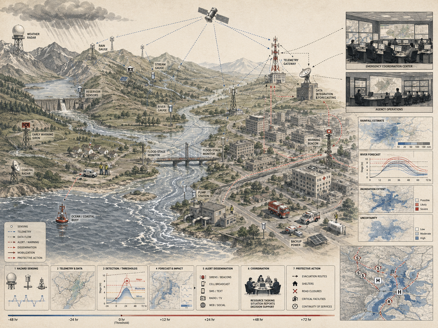
A practical reference architecture for flood and disaster early warning infrastructure links risk knowledge to protective action. The exact design varies across river floods, flash floods, coastal floods, storms, heat waves, wildfire smoke, landslides, dam-related hazards, and compound events, but the responsibilities remain consistent: understand risk, observe hazards, forecast impacts, issue warnings, disseminate through redundant channels, reach exposed populations, support preparedness, and review performance after events.
| Layer | Engineering Role | Primary Risk | Evidence Artifact |
|---|---|---|---|
| Risk knowledge layer | Maps hazards, exposure, vulnerability, critical infrastructure, evacuation constraints, and likely impacts. | Warnings are issued without knowing who and what is at risk. | Risk register, exposure inventory, vulnerability table, local knowledge record |
| Observation and telemetry layer | Collects rainfall, river stage, radar, satellite, soil moisture, coastal, and field observations. | Hazard detection is incomplete, delayed, uncalibrated, or unavailable during extreme events. | Observation network inventory, sensor-status log, telemetry uptime record |
| Forecast and impact layer | Transforms observations into hazard forecasts, impact estimates, lead-time windows, and warning thresholds. | Forecasts remain technical products rather than actionable risk information. | Forecast product register, threshold table, impact-based forecast note |
| Warning authority layer | Defines who can issue warnings, what triggers them, how uncertainty is handled, and how agencies coordinate. | Institutional hesitation or contradictory messages delay protective action. | Warning protocol, authority matrix, escalation procedure, false-alarm policy |
| Dissemination and communications layer | Uses cell broadcast, SMS, sirens, radio, television, internet, satellite, social media, and community channels. | Warnings do not reach people under real disaster conditions. | Channel map, redundancy plan, delivery logs, communications test record |
| Preparedness and response layer | Connects warnings to evacuation, sheltering, emergency services, anticipatory action, and community response. | Warnings are received but cannot be acted upon. | Protective-action protocol, evacuation plan, shelter register, drill record |
| Inclusion and accessibility layer | Ensures warnings are reachable, understandable, trusted, and actionable for vulnerable and marginalized groups. | Formal coverage masks exclusion in practice. | Accessibility review, language plan, disability support protocol, community-trust record |
| Monitoring and learning layer | Measures lead time, reach, comprehension, action, outcomes, false alarms, missed events, and system reliability. | Warning failures repeat because evidence is not collected or acted on. | After-action review, performance dashboard, improvement log |
This architecture makes clear that early warning is not a message at the end of a pipeline. It is an integrated warning-action system whose failure at any point can degrade the protective value of the whole chain.
Implementation Pattern
A rigorous implementation pattern begins with protective action rather than alert technology. Public agencies should define what action must occur before impact, who must act, what information they need, how much lead time is required, which channels will reach them, and which populations require additional support. Only then should institutions choose specific observing systems, forecast models, warning platforms, sirens, cell broadcast arrangements, dashboards, or emergency communications workflows.
| Artifact | Purpose | Suggested Format |
|---|---|---|
| Early warning objective manifest | Defines scope, hazards, exposed services, warning purpose, valid-use limits, and protective-action goals. | YAML, Markdown, architecture decision record |
| Hazard and exposure register | Documents hazards, affected communities, critical assets, lead-time needs, and impact pathways. | CSV, SQL table, GeoJSON |
| Observation network inventory | Tracks gauges, radar, satellites, stations, telemetry, maintenance, uptime, and calibration status. | CSV, SQL table, sensor registry |
| Forecast product register | Documents forecast type, model owner, hazard, lead time, uncertainty, threshold, and impact interpretation. | CSV, YAML, model card |
| Warning channel register | Tracks cell broadcast, SMS, sirens, radio, television, social media, satellite, and community channels. | CSV, SQL table, channel map |
| Accessibility and inclusion review | Assesses language, disability access, device access, connectivity, literacy, trust, mobility, and shelter access. | CSV, checklist, community review |
| Preparedness and protective-action log | Connects warnings to evacuation, sheltering, road closures, anticipatory action, drills, and response capacity. | CSV, SQL table, emergency-management record |
| Governance and after-action log | Documents authority, thresholds, exercises, event reviews, false alarms, missed events, and improvement actions. | CSV, SQL table, after-action review |
| Public evidence package | Explains warning coverage, known gaps, accessibility caveats, response protocols, and accountability. | Markdown, HTML, PDF |
The implementation goal is to make early-warning claims reconstructable. A reader should be able to move from a coverage statement, readiness score, warning-performance claim, or public safety assertion back to the hazard evidence, observing network, forecast product, warning channel, accessibility review, response protocol, and governance record that support it.
Research-Grade Framing: Early Warning as Public-Safety Infrastructure
A research-grade account of early warning begins by treating warning as public-safety infrastructure rather than a notification service. Forecasts, alerts, sirens, and mobile messages matter, but their purpose is to enable protective action under conditions of uncertainty, stress, and unequal vulnerability. A warning system is mature only when detection, interpretation, dissemination, trust, preparedness, and response capacity work together.
This framing matters because disaster harm is produced through interaction: hazard intensity, exposure, vulnerability, infrastructure fragility, institutional capacity, communication reach, and feasible response. A warning that reaches some populations but not others can reproduce inequality. A warning that arrives without clear action guidance can fail even when technically accurate. A warning that depends on a single communication channel can fail precisely when disaster conditions degrade that channel.
Early warning also requires humility. Forecasts contain uncertainty, alerts can be misunderstood, false alarms can erode trust, local risk knowledge may reveal exposure that models miss, and some communities may face structural barriers to action. The goal is therefore not only more advanced prediction. It is a more reliable warning-action chain that can protect people under real conditions, especially where vulnerability and exposure are highest.
| Limited Pattern | Stronger Pattern | Why the Shift Matters |
|---|---|---|
| Send alerts | Support timely, feasible protective action | Disaster risk is reduced by action, not by messages alone. |
| Forecast hazards | Interpret likely impacts for people, places, assets, and services | Hazard information must become local risk knowledge. |
| Measure technical coverage | Measure reach, comprehension, trust, accessibility, and response capacity | Formal coverage can hide exclusion in practice. |
| Use a primary communications channel | Build redundant multi-channel dissemination with backup paths | Disaster conditions can degrade telecommunications and power. |
| Issue warnings from a central authority | Coordinate national, regional, local, community, and sector-specific action | Warning chains often fail at institutional handoffs. |
The central research question is therefore: how can early warning systems transform risk knowledge into protective action quickly, inclusively, and reliably under disaster conditions?
Formal Model: Detection, Lead Time, Reach, Trust, and Protective Action
A useful formal model separates hazard detection, forecast lead time, warning dissemination, population reach, comprehension, trust, feasible action, and protective outcome. Let \(H_i\) represent hazard intensity for event \(i\), \(D_i\) detection probability, \(L_i\) useful lead time, \(R_i\) dissemination reach, \(C_i\) comprehension, \(T_i\) trust, \(A_i\) feasible action capacity, and \(V_i\) vulnerability.
P_{\mathrm{protective},i} = D_i \times R_i \times C_i \times T_i \times A_i
\]
Interpretation: Protective warning probability depends on detection, reach, comprehension, trust, and feasible action. A weakness in any term reduces the protective value of the whole warning chain.
L^{\mathrm{useful}}_i = L_i – T_{\mathrm{decision},i} – T_{\mathrm{communication},i} – T_{\mathrm{mobilization},i}
\]
Interpretation: Useful lead time is what remains after decision, communication, and mobilization delays. A long forecast lead time may still produce little practical time for action.
Q_{\mathrm{warning}} =
w_1K +
w_2O +
w_3F +
w_4M +
w_5P +
w_6I +
w_7G
\]
Interpretation: Warning-system quality combines risk knowledge \(K\), observation \(O\), forecasting \(F\), messaging \(M\), preparedness \(P\), inclusion \(I\), and governance \(G\).
R_{\mathrm{residual},g} = H_g \times E_g \times V_g \times (1 – P_{\mathrm{protective},g})
\]
Interpretation: Residual disaster risk for group \(g\) remains high when hazard, exposure, and vulnerability are high and protective warning probability is low.
C_{\mathrm{equity}} =
\frac{P_{\mathrm{protective},\mathrm{vulnerable}}}{P_{\mathrm{protective},\mathrm{general}}}
\]
Interpretation: Equity coverage compares protective warning capability for vulnerable populations with the general population. Values below one indicate unequal warning protection.
This formal structure protects against a common mistake in warning-system design: treating alert issuance as protection. Protection depends on whether warning chains actually reach, inform, and enable people before impact.
What Is Flood and Disaster Early Warning Infrastructure?
Flood and disaster early warning infrastructure is the integrated architecture through which hazards are monitored, forecast, translated into warnings, communicated to exposed populations, and connected to protective action. It includes both physical and digital assets, but also operating procedures, institutional mandates, response planning, accessibility measures, trusted communication channels, and community-facing systems that make warning usable.
This is broader than alerting technology alone. A flood-warning system may include river gauges, rainfall stations, radar, hydrological models, operations centers, telecom networks, emergency protocols, local officials, shelters, evacuation routes, and community mobilization arrangements. A disaster-warning system for storms, heat, drought, wildfire, landslides, or compound hazards may rely on different sensing architectures, but the same basic logic holds: warning becomes meaningful only when the full chain from detection to action remains intact.
Early warning infrastructure is therefore best understood as public-safety infrastructure. It creates the conditions under which institutions can detect emerging danger early enough to support timely action rather than late-stage reaction. In practical terms, the infrastructure of warning includes not just sensors and forecasts, but also roads that support evacuation, shelters that can receive people, electrical continuity for communication systems, and institutional authority to trigger action without paralysis or delay.
Why Early Warning Must Be Infrastructural
Early warning must be infrastructural because disaster risk is not reduced by information alone. Hazards become disasters through exposure, vulnerability, weak communication, fragile infrastructure, and limited response capacity. A warning system that functions only intermittently, reaches only part of the population, or is disconnected from preparedness arrangements cannot reliably protect people or assets. Universal coverage in principle matters little if actual protective capacity remains fragmented in practice.
This is especially important for floods, where lead times may range from days to minutes and where impacts depend heavily on terrain, drainage, settlement patterns, infrastructure condition, prior saturation, road access, and social vulnerability. It is equally important for compound hazards, where a warning must often work within rapidly deteriorating infrastructure conditions. A message is not enough if the communications network fails, if roads are already cut off, if shelters are inaccessible, if households cannot move, or if local authorities cannot validate and relay the warning in time.
Infrastructural thinking is also important because early warning depends on continuity and maintenance. Gauges must remain calibrated. Forecast models must be updated. Telecommunications systems must be resilient. Public alert channels must be tested. Roles must be clear before the emergency occurs. A warning system that functions only under ideal conditions is not real warning infrastructure. It is a fragile technical capability masquerading as public protection.
| Infrastructure Need | Warning Function | Failure If Missing |
|---|---|---|
| Observation network | Detects rainfall, river levels, storms, heat, smoke, coastal surge, or other hazards. | Hazard conditions are detected late or not at all. |
| Forecast and impact modeling | Translates observations into anticipated location-specific risk. | Warnings remain too general to support protective decisions. |
| Communications redundancy | Disseminates warnings across multiple channels under degraded conditions. | Alerts fail when telecommunications, power, or internet systems degrade. |
| Preparedness protocols | Connects warnings to evacuation, sheltering, road closures, and emergency action. | People receive warnings but do not know or cannot do what is needed. |
| Accessibility and inclusion | Makes warnings usable across language, disability, device access, mobility, and trust differences. | The people most at risk may be least protected. |
Early warning becomes credible when it is designed as an operational public-safety system, not as an information broadcast detached from response capacity.
Core Architecture of Early Warning Systems
Flood and disaster early warning infrastructure can be understood through a layered architecture that links detection to public action. These layers are often associated with the logic of multi-hazard early warning: risk knowledge, observation and forecasting, warning dissemination and communication, and preparedness to respond. A systems view expands that logic into operational evidence, inclusion, governance, and learning.
Risk Knowledge Layer
This layer includes hazard mapping, vulnerability analysis, exposure data, historical records, infrastructure dependency maps, evacuation constraints, and local knowledge about who and what is at risk. Warnings have limited value if institutions do not understand where impacts are likely to fall, which groups are most exposed, and what protective options are actually available.
Observation and Forecasting Layer
This layer includes monitoring stations, river gauges, rainfall networks, radar, satellite inputs, soil moisture observations, forecasting models, hydrological models, and analytics that allow institutions to detect hazardous conditions and estimate likely impacts. For flood risk in particular, this layer often requires combining meteorology with hydrology, drainage conditions, land use, and impact-based forecasting.
Warning Dissemination and Communication Layer
This layer includes emergency telecommunications, public-alert systems, mass messaging, radio, television, sirens, cell broadcast, location-based SMS, mobile applications, satellite broadcast, social media, community networks, and trusted local messengers. This layer matters because a good forecast that does not travel effectively remains operationally weak.
Preparedness and Response Layer
This layer includes evacuation planning, sheltering, anticipatory action, community training, emergency services coordination, road closure procedures, continuity planning, and institutional protocols for acting on warnings. It is the layer that determines whether alerts translate into reduced harm.
Governance and Learning Layer
This layer includes warning authority, thresholds, mandates, maintenance budgets, drills, after-action reviews, accessibility commitments, performance metrics, and public accountability. It determines whether the warning system improves over time or repeats the same failure modes.
| Layer | Core Capability | Maturity Question |
|---|---|---|
| Risk knowledge | Hazard, exposure, vulnerability, local knowledge, infrastructure dependency | Do warning institutions understand who and what is at risk? |
| Observation and forecasting | Monitoring, telemetry, forecast models, thresholds, impact interpretation | Can hazards and likely impacts be detected early enough to act? |
| Dissemination and communication | Multi-channel warning delivery, redundancy, message clarity, accessibility | Can warnings reach exposed populations under real disaster conditions? |
| Preparedness and response | Evacuation, sheltering, emergency coordination, anticipatory action, drills | Can people and institutions act on warnings before impact? |
| Governance and learning | Authority, standards, maintenance, review, public evidence, improvement cycles | Does the system learn from warnings, false alarms, missed events, and community experience? |
Warning infrastructure is only as strong as its weakest operational link. Strengthening a single layer does not compensate for a broken chain.
Flood Warning as a Distinct Infrastructure Challenge
Flood warning deserves special emphasis because it is not a single technical problem. Riverine flooding, flash flooding, coastal inundation, drainage overload, dam-related flooding, and compound urban flooding all create different warning challenges. River floods may allow longer lead times but require basin-scale monitoring and downstream coordination. Flash floods can emerge rapidly with little time for deliberation and demand dense local observation, fast model updates, and extremely efficient communication. Urban flooding may depend less on river levels alone and more on impermeable surfaces, clogged drainage, under-capacity stormwater systems, and exposure of transport corridors, informal settlements, and low-lying neighborhoods.
This matters because flood-warning infrastructure must translate rainfall and hydrological conditions into place-specific public protection. A forecast of heavy rainfall is not yet a flood warning in a meaningful sense. Institutions must still interpret what that rainfall means for river levels, urban runoff, drainage systems, road passability, neighborhood exposure, transit continuity, emergency access, and shelter timing. In many settings, the difficulty lies not in detecting rain, but in understanding how the built environment will transform rain into dangerous flood conditions.
Flood warning is therefore infrastructurally distinctive because it sits at the boundary of weather, hydrology, land use, drainage engineering, transport continuity, housing vulnerability, and social protection. A mature flood-warning system requires not only observing networks and models, but knowledge of where water will go, who will be trapped first, which roads will fail, and how quickly protective action can realistically occur.
| Flood Type | Warning Challenge | Infrastructure Requirement |
|---|---|---|
| Riverine flood | Downstream timing, basin coordination, stage thresholds | River gauges, hydrological model, basin communication protocol |
| Flash flood | Very short lead time, localized intensity, rapid public action | Dense rainfall observation, fast alerting, community action triggers |
| Urban drainage flood | Runoff, drainage capacity, blocked inlets, road passability | Stormwater sensors, drainage maps, transport closure protocols |
| Coastal flood | Surge, tides, sea-level baseline, evacuation timing | Coastal gauges, surge forecasts, evacuation and shelter coordination |
| Compound flood | Rainfall, river flow, surge, drainage, power loss, transport disruption | Multi-hazard models, interagency coordination, redundant communications |
Flood-warning maturity depends on whether hydrometeorological knowledge can be converted into local action before water makes action impossible.
Multi-Hazard Design and Cascading Risk
Contemporary warning systems are increasingly framed as multi-hazard systems because communities are rarely exposed to one risk at a time. Floods may coincide with storms, landslides, heat stress, dam releases, infrastructure outages, contamination events, or disease risk. Multi-hazard framing matters because it reflects how disasters actually unfold across systems rather than how hazards are categorized administratively.
This changes warning-system design in important ways. A flood warning during a power outage requires communications redundancy. A storm warning in a city already affected by extreme heat may shift shelter needs and public-health risk. A landslide risk warning following intense rainfall may require road closures that affect evacuation and emergency response. A coastal flood can become a transport failure, then a logistics failure, then a public-health and sheltering crisis. Each step in this chain changes what the warning must accomplish.
Early warning infrastructure is strongest when it can support this broader logic of cascading failure. It must account not only for the initial hazard, but for the way infrastructure interdependencies reshape risk once disruption begins. In practice, multi-hazard warning is less about building separate alert systems for each hazard than about building interoperable systems capable of supporting compound interpretation and coordinated public action.
| Initial Hazard | Possible Cascade | Warning-System Implication |
|---|---|---|
| Extreme rainfall | Urban flooding, road closures, drainage failure, sewer overflow | Warnings must include mobility, sanitation, and shelter implications. |
| Coastal storm surge | Power loss, communications degradation, evacuation constraints | Warnings require redundant channels and early evacuation triggers. |
| Wildfire smoke | Health risk, shelter demand, transport disruption, power shutdown | Warnings must connect air-quality information to health-protective action. |
| Heat wave | Power stress, water demand, health emergencies, cooling center overload | Warnings must identify cooling access, vulnerable populations, and grid constraints. |
| Dam release or failure concern | Downstream flood wave, evacuation pressure, road network stress | Warnings require pre-scripted authority, timing, routing, and shelter coordination. |
Multi-hazard early warning is therefore a systems-integration discipline. Its purpose is not merely to issue many alert types, but to interpret interacting risk fast enough to support coordinated action.
Warning Dissemination, Last-Mile Reach, and Public Action
One of the most persistent weaknesses in early warning is not hazard detection but last-mile delivery. Forecasts and alerts may exist yet fail to reach exposed populations in time, in accessible formats, through trusted channels, or with action guidance that people can use. Dissemination infrastructure is therefore the bridge between institutional awareness and public protection.
This matters because warning is only protective when it can be received, understood, trusted, and acted upon. A technically correct message that arrives too late, in the wrong language, through a channel people do not use, or without clear protective instructions may fail despite strong forecasting. Warning infrastructure therefore depends not only on network coverage, but on message design, accessibility, institutional clarity, public preparedness, and feasible action routes.
Last-mile infrastructure is not an optional communications layer. It is a core determinant of whether early warning functions as life-saving public infrastructure or merely as technical notification. Public action depends on clarity, feasibility, and trust. If any of those are missing, warning dissemination may occur without real protection.
| Channel | Strength | Limitation to Address |
|---|---|---|
| Cell broadcast | Can reach many devices rapidly in a geographic area. | Requires device access, network function, clear message design, and accessibility support. |
| SMS or mobile messaging | Useful for targeted warnings and follow-up information. | May depend on subscription lists, network congestion, literacy, and language access. |
| Sirens | Can alert people outdoors and without phones. | Often communicates urgency but not detailed protective action. |
| Radio and television | Supports repeated information and trusted public broadcasting. | May not reach people without power, access, or attention during fast-onset hazards. |
| Community networks | Can reach people through trusted local relationships and local knowledge. | Requires training, resources, and integration with official warning protocols. |
| Social media and web platforms | Can spread updates quickly and support visual information. | Can exclude people without connectivity and may amplify misinformation. |
A mature dissemination system uses multiple channels because no single channel serves all people under all hazard conditions.
Inclusion, Accessibility, and Unequal Exposure
Flood and disaster risk is distributed unevenly, and warning systems can reproduce that inequality if they are not designed inclusively. Low-income populations, people living in informal settlements, older adults, disabled people, migrants, people without reliable mobile access, linguistically marginalized communities, climate-exposed workers, and people with limited transport access may face higher exposure and weaker access to warnings at the same time.
This matters because universal coverage in principle does not guarantee universal protection in practice. A mobile alert may not reach someone without service, literacy support, or device access. A siren may alert people but not explain what action is needed. An evacuation order may be received but unusable if transport, shelter, caregiving support, or trust are inadequate. In many places, the populations most exposed to flood and disaster risk are also the least well served by formal communication infrastructures.
Early warning infrastructure should therefore be judged not only by technical reach, but by whether it improves protective capability for the people most at risk. A system that performs well for connected, mobile, better-resourced populations while failing the most exposed cannot reasonably be called mature public-warning infrastructure.
| Barrier | Warning Failure Mode | Design Response |
|---|---|---|
| Language access | Warnings are received but not understood. | Multilingual templates, local translation protocols, community messengers. |
| Disability access | Warnings are not accessible to people with hearing, visual, cognitive, or mobility-related needs. | Multi-format alerts, accessible shelters, caregiver protocols, disability-inclusive drills. |
| Device and connectivity gaps | Mobile warnings miss people without phones, service, power, or data. | Sirens, radio, door-to-door networks, satellite backup, local broadcast. |
| Mobility constraints | People receive warnings but cannot evacuate or reach shelter. | Transport assistance, accessible evacuation planning, neighborhood shelters. |
| Low institutional trust | People ignore warnings because past communication was unreliable, exclusionary, or harmful. | Community partnerships, transparency, drills, trusted local intermediaries. |
Inclusion is not a communications add-on. It is part of the warning system’s protective function because warnings that exclude vulnerable people fail where protection is needed most.
Governance, Standards, and Institutional Capacity
Early warning is a governance problem as much as a technical one. Institutions must decide who monitors hazards, who issues alerts, what thresholds trigger action, which channels are used, how agencies coordinate, how false alarms are handled, how warnings are evaluated, and how systems are financed and maintained. These decisions shape whether warning systems act decisively or stall at critical moments.
The warning chain often breaks at points of institutional handoff rather than at points of detection. Forecasting agencies may produce credible hazard information, yet local authorities may hesitate to issue evacuation orders. Emergency managers may send alerts, yet telecom channels may not be fully integrated. National agencies may have strong systems, while municipalities lack the staff or protocols to translate warnings into neighborhood-level action. The technical and institutional chain must therefore be treated as a single system rather than as separate domains.
Standards and coordination matter because fragmented responsibilities can delay action or create contradictory messages. Telecommunications authorities, meteorological agencies, disaster-management bodies, local governments, emergency services, utilities, transport operators, health agencies, and community organizations all play roles in functioning warning systems. Institutional capacity matters just as much. A country can possess sensors, forecasts, and telecom infrastructure yet still have weak warning performance if maintenance is poor, mandates are unclear, drills are absent, or communities do not trust official guidance.
| Capability | Purpose | Evidence Artifact |
|---|---|---|
| Warning authority | Defines who can issue warnings and under what thresholds. | Authority matrix, escalation protocol, threshold policy |
| Interagency coordination | Links meteorology, hydrology, emergency management, telecom, local government, and response agencies. | Coordination charter, operations-center protocol, joint exercise record |
| Communications governance | Ensures alert channels are integrated, tested, redundant, and accessible. | Channel register, telecom agreement, delivery test log |
| Community preparedness | Connects warnings to drills, shelters, evacuation, local knowledge, and trust. | Preparedness plan, drill record, community partner register |
| Learning and accountability | Reviews warnings, false alarms, missed events, outcomes, and improvement actions. | After-action review, performance dashboard, public evidence package |
Early warning infrastructure is therefore not only technical infrastructure. It is institutional infrastructure for credibility, coordination, and action.
Measurement, Coverage, and Early Warning Performance
Measurement matters because early warning systems need ways to assess whether they are actually protecting people. Relevant indicators may include hazard coverage, observation uptime, forecast lead time, threshold accuracy, warning issuance time, dissemination reach, communication redundancy, population coverage, accessibility, response readiness, protective action, false alarms, missed events, and observed outcomes.
But performance cannot be reduced to the existence of an alerting platform alone. A country or region may report technical warning capability while remaining weak in risk knowledge, last-mile communication, accessibility, or preparedness to respond. This is why multi-pillar frameworks are useful: they discourage the illusion that one strong component can substitute for a functioning system.
Indicators are most useful when they help institutions identify where warning chains break down and how protective capability can be improved for exposed populations. The real test of performance is not whether a warning was issued, but whether it arrived in time, was trusted, was actionable, and changed outcomes.
| Indicator Type | Example Measure | Interpretive Caution |
|---|---|---|
| Observation performance | Gauge uptime, telemetry latency, station coverage, calibration status | Coverage does not guarantee impact interpretation. |
| Forecast performance | Lead time, skill, uncertainty, threshold accuracy, false alarm rate | Forecast skill does not guarantee protective action. |
| Dissemination reach | Share of exposed population reached by at least one warning channel | Reach can hide comprehension, trust, and accessibility gaps. |
| Preparedness readiness | Evacuation route availability, shelter capacity, drill completion, response staffing | Plans may fail if not practiced under realistic conditions. |
| Protective action | Evacuation, sheltering, road closure, asset protection, anticipatory assistance | Action depends on feasibility, not only instruction. |
| Equity and accessibility | Warning reach and feasible response for vulnerable populations | General population metrics can hide unequal warning protection. |
Good early-warning measurement should improve systems, not merely count alerts.
Deployment Readiness Gate
Before flood and disaster early warning infrastructure is used for public claims, emergency operations, investment prioritization, or warning-performance reporting, it should pass a readiness gate. The purpose is not to slow action. It is to confirm that warning capability is connected to real protective capacity.
| Readiness Check | Pass Condition | Evidence |
|---|---|---|
| Hazard and exposure scope | Hazards, communities, critical services, and vulnerable populations are defined. | Hazard and exposure register |
| Observation coverage | Monitoring assets, telemetry, maintenance, and calibration status are documented. | Observation network inventory |
| Forecast and threshold logic | Forecast products, lead times, thresholds, uncertainty, and impact interpretation are defined. | Forecast product register |
| Warning authority | Issuing authority, escalation, false-alarm policy, and agency handoff rules are clear. | Warning protocol and authority matrix |
| Dissemination redundancy | Multiple warning channels are available, tested, and mapped to exposed populations. | Warning channel register and delivery test log |
| Inclusion and accessibility | Language, disability, connectivity, mobility, trust, and shelter barriers are assessed. | Accessibility and inclusion review |
| Preparedness to respond | Warnings are connected to evacuation, sheltering, protective action, and drills. | Preparedness log, drill record, shelter register |
| Learning and accountability | After-action review, performance indicators, public evidence, and improvement cycles are defined. | Governance and after-action log |
Any warning system that cannot pass this readiness gate should be treated as incomplete public-safety infrastructure, even if it has sophisticated sensors or alerting software.
Data and Configuration Artifacts
The companion repository uses a data-first structure so that early-warning claims can be examined rather than merely asserted. Each artifact has a specific role in making the warning-action chain reconstructable across hazards, observing systems, forecasts, communications, preparedness, inclusion, and governance.
| Artifact | File | Purpose |
|---|---|---|
| Early warning objective manifest | config/early_warning_objective.yml |
Defines hazards, scope, public-safety purpose, decision uses, and valid-use caveats. |
| Hazard and exposure register | data/hazard_exposure_register.csv |
Documents hazards, exposed communities, critical services, vulnerability, and lead-time needs. |
| Observation network inventory | data/observation_network_inventory.csv |
Tracks gauges, radar, stations, telemetry, maintenance, uptime, and calibration. |
| Forecast product register | data/forecast_product_register.csv |
Documents forecast types, thresholds, uncertainty, lead time, and impact interpretation. |
| Warning channel register | data/warning_channel_register.csv |
Tracks dissemination channels, redundancy, coverage, accessibility, and test status. |
| Preparedness action log | data/preparedness_action_log.csv |
Connects warning thresholds to evacuation, sheltering, route closure, and anticipatory action. |
| Inclusion review | data/accessibility_inclusion_review.csv |
Reviews language, disability, mobility, device, trust, and connectivity barriers. |
| SQL schema | sql/schema.sql |
Creates a local SQLite database for warning-system evidence and reporting. |
These artifacts are designed to make the warning chain auditable. They can be replaced with institutional datasets later, but the scaffold keeps the analytical logic visible from the beginning.
Mathematical Lens: Warning Chain Reliability and Protective Reach
A lightweight mathematical lens helps distinguish alerting from protection. The point is not to reduce early warning to a single number, but to make visible the multiplicative nature of warning-chain reliability.
P_{\mathrm{protective},i} = D_i \times R_i \times C_i \times T_i \times A_i
\]
Interpretation: Protective warning probability falls when detection, reach, comprehension, trust, or action capacity is weak. This is why a warning chain can fail even when one component is strong.
L^{\mathrm{useful}}_i = L_i – T_{\mathrm{decision},i} – T_{\mathrm{communication},i} – T_{\mathrm{mobilization},i}
\]
Interpretation: Useful lead time is the time left for protective action after institutional decision, message delivery, and mobilization delays.
Q_{\mathrm{chain}} =
\prod_{j=1}^{n} q_j
\]
Interpretation: Overall warning-chain reliability depends on the product of component reliabilities. Weak links matter disproportionately.
This mathematical framing should be used as a structured diagnostic, not as a substitute for emergency-management judgment, local knowledge, accessibility review, or community trust-building.
Python Workflow: Early Warning Coverage and Protective Action Review
The Python workflow in the companion repository reads hazard, observation, forecast, channel, preparedness, and inclusion data; computes warning-chain readiness and useful lead time; and exports watchlists for governance review. The sample below illustrates the core logic.
from pathlib import Path
import pandas as pd

ARTICLE_DIR = Path("articles/flood-and-disaster-early-warning-infrastructure-detection-communication-and-protective-action")
DATA_DIR = ARTICLE_DIR / "data"
OUTPUT_DIR = ARTICLE_DIR / "outputs"
OUTPUT_DIR.mkdir(parents=True, exist_ok=True)

hazards = pd.read_csv(DATA_DIR / "hazard_exposure_register.csv")
forecasts = pd.read_csv(DATA_DIR / "forecast_product_register.csv")
channels = pd.read_csv(DATA_DIR / "warning_channel_register.csv")
preparedness = pd.read_csv(DATA_DIR / "preparedness_action_log.csv")

df = hazards.merge(forecasts, on="hazard_id", how="left")
df = df.merge(channels, on="warning_zone_id", how="left")
df = df.merge(preparedness, on="warning_zone_id", how="left")

df["useful_lead_time_minutes"] = (
    df["forecast_lead_time_minutes"]
    - df["decision_delay_minutes"]
    - df["communication_delay_minutes"]
    - df["mobilization_time_minutes"]
)

df["protective_warning_probability"] = (
    df["detection_reliability"]
    * df["population_reach"]
    * df["message_comprehension"]
    * df["trust_score"]
    * df["action_capacity"]
)

df["residual_warning_risk"] = (
    df["hazard_severity"]
    * df["exposure_score"]
    * df["vulnerability_score"]
    * (1 - df["protective_warning_probability"])
)

watchlist = df[
    (df["criticality"].eq("high")) &
    ((df["useful_lead_time_minutes"] < 20) | (df["residual_warning_risk"] >= 0.25))
].sort_values(["residual_warning_risk", "useful_lead_time_minutes"], ascending=[False, True])

df.to_csv(OUTPUT_DIR / "early_warning_chain_review.csv", index=False)
watchlist.to_csv(OUTPUT_DIR / "early_warning_governance_watchlist.csv", index=False)

print(watchlist[["hazard_id", "community_name", "hazard_type", "useful_lead_time_minutes", "residual_warning_risk"]])
This is a deliberately transparent workflow. It allows analysts to see whether warning weakness comes from detection, lead time, communication reach, trust, accessibility, action capacity, or governance delay.
R Workflow: Warning Coverage, Accessibility, and Governance Reporting
The R workflow summarizes warning readiness across hazard types and highlights where vulnerable communities remain exposed because protective warning probability is low or useful lead time is insufficient.
library(readr)
library(dplyr)

article_dir <- "articles/flood-and-disaster-early-warning-infrastructure-detection-communication-and-protective-action"
data_dir <- file.path(article_dir, "data")
output_dir <- file.path(article_dir, "outputs")
dir.create(output_dir, recursive = TRUE, showWarnings = FALSE)

hazards <- read_csv(file.path(data_dir, "hazard_exposure_register.csv"), show_col_types = FALSE)
forecasts <- read_csv(file.path(data_dir, "forecast_product_register.csv"), show_col_types = FALSE)
channels <- read_csv(file.path(data_dir, "warning_channel_register.csv"), show_col_types = FALSE)
preparedness <- read_csv(file.path(data_dir, "preparedness_action_log.csv"), show_col_types = FALSE)
inclusion <- read_csv(file.path(data_dir, "accessibility_inclusion_review.csv"), show_col_types = FALSE)

report <- hazards %>%
  left_join(forecasts, by = "hazard_id") %>%
  left_join(channels, by = "warning_zone_id") %>%
  left_join(preparedness, by = "warning_zone_id") %>%
  left_join(inclusion, by = "warning_zone_id") %>%
  mutate(
    useful_lead_time_minutes = forecast_lead_time_minutes -
      decision_delay_minutes -
      communication_delay_minutes -
      mobilization_time_minutes,
    protective_warning_probability = detection_reliability *
      population_reach *
      message_comprehension *
      trust_score *
      action_capacity,
    residual_warning_risk = hazard_severity *
      exposure_score *
      vulnerability_score *
      (1 - protective_warning_probability),
    accessibility_gap = 1 - accessibility_readiness
  )

hazard_summary <- report %>%
  group_by(hazard_type) %>%
  summarise(
    zones = n_distinct(warning_zone_id),
    mean_useful_lead_time = mean(useful_lead_time_minutes, na.rm = TRUE),
    mean_protective_probability = mean(protective_warning_probability, na.rm = TRUE),
    mean_residual_warning_risk = mean(residual_warning_risk, na.rm = TRUE),
    high_accessibility_gap_zones = sum(accessibility_gap >= 0.35, na.rm = TRUE),
    .groups = "drop"
  ) %>%
  arrange(desc(mean_residual_warning_risk))

write_csv(report, file.path(output_dir, "early_warning_accessibility_report.csv"))
write_csv(hazard_summary, file.path(output_dir, "early_warning_hazard_summary.csv"))

print(hazard_summary)
The purpose is not to produce a definitive warning-system ranking. It is to reveal where detection, dissemination, accessibility, trust, and action capacity are limiting public protection.
Systems Code: Hazard Registers, Dissemination Channels, and Preparedness Logs
The companion repository extends the article into a reproducible systems scaffold. Python and R support analytical review; SQL stores evidence; YAML files define objectives and scoring policies; GeoJSON provides spatial placeholders; TypeScript can support dashboard interfaces; Go can support lightweight warning-status services; Rust can support validation utilities; and shell scripts coordinate local workflow checks.
| Directory | Role | Example Use |
|---|---|---|
python/ |
Warning-chain scoring, residual-risk review, governance watchlists | Compute useful lead time and protective warning probability |
r/ |
Hazard summaries, accessibility reporting, warning-performance indicators | Summarize residual warning risk and inclusion gaps |
sql/ |
Evidence tables and auditable queries | Join hazards, forecasts, channels, preparedness, and inclusion records |
config/ |
Early-warning objective and scoring policies | Define valid uses, weights, caveats, and readiness rules |
schemas/ |
JSON schemas for core records | Validate hazard, observation, forecast, and warning-channel data |
typescript/ |
Dashboard/interface scaffold | Display early-warning readiness and warning-chain gaps |
go/ |
Status-service scaffold | Prototype a lightweight early-warning readiness endpoint |
rust/ |
Strict validation and CLI scaffolding | Validate records and produce structured warnings |
The code is intentionally modular so that article-level examples can be expanded into a larger research-grade early-warning infrastructure toolkit over time.
GitHub Repository
Complete Code Repository
The companion repository contains reproducible scaffolding for hazard registers, observation networks, forecast products, warning-channel coverage, accessibility reviews, preparedness protocols, governance logs, SQL metadata, and multi-language early warning infrastructure workflows.
Testing and Validation
Testing early warning infrastructure requires more than checking whether code runs or whether an alert can be sent. Validation should examine whether the warning chain represents real protective action, whether warnings reach vulnerable populations, whether lead time remains useful after institutional delays, whether communication channels work under degraded conditions, and whether governance outputs avoid false confidence.
| Validation Area | Test Question | Failure Signal |
|---|---|---|
| Hazard and exposure data | Are hazards, warning zones, exposed communities, and vulnerable populations documented? | Warnings are issued without clear knowledge of who is at risk. |
| Observation reliability | Are gauges, telemetry, radar, stations, and calibration records current? | Warning decisions depend on incomplete or unmaintained observation networks. |
| Lead-time usefulness | Does useful lead time remain after decision, communication, and mobilization delays? | Forecast lead time appears adequate, but practical action time is too short. |
| Dissemination redundancy | Can warnings still reach people if one channel fails? | System depends on a single channel under disaster conditions. |
| Accessibility and inclusion | Are warnings accessible by language, disability, mobility, device access, and trust? | General coverage is high while vulnerable-population protection is low. |
| Preparedness to respond | Are warnings connected to evacuation, sheltering, route closure, and drills? | Alerts are received but people lack feasible action pathways. |
Validation should be repeated after drills, false alarms, missed events, major disasters, communications failures, and changes in population exposure.
Operational Signals and Early Warning Observability
Early warning observability means being able to see whether warning systems are functioning before, during, and after hazard events. This requires signals that connect observation, forecasting, alert delivery, public reception, preparedness, and protective action rather than treating each domain separately.
| Signal | What It Reveals | Operational Use |
|---|---|---|
| Observation uptime and telemetry latency | Whether hazard data are available in time for warning decisions | Sensor maintenance, redundancy planning, and data-quality review |
| Forecast lead time and threshold performance | Whether forecast products support action before impact | Threshold revision, impact-based forecasting, model review |
| Warning issuance and delivery time | Whether institutional and communications delays reduce useful lead time | Escalation protocol review and channel performance testing |
| Population reach and accessibility | Whether warnings reach vulnerable and marginalized populations | Inclusion review, channel expansion, community partnership |
| Protective action completion | Whether warnings led to evacuation, sheltering, route closures, or other actions | Preparedness planning and drill design |
| After-action findings | Whether false alarms, missed events, or communication failures are being corrected | Governance learning and public accountability |
Early warning observability is strongest when it treats detection, communication, preparedness, and public action as one chain of evidence.
Engineer and Researcher Checklist
- Define the hazards, exposed communities, infrastructure services, and protective actions the warning system must support.
- Document observation assets, telemetry, calibration, uptime, maintenance, and backup arrangements.
- Connect forecasts to impact-based thresholds, uncertainty, lead time, and local exposure.
- Define who can issue warnings, when warnings escalate, and how uncertainty is handled.
- Use redundant warning channels rather than relying on one dissemination pathway.
- Test warnings for language, disability access, device access, connectivity, mobility, literacy, and trust.
- Connect warnings to evacuation, sheltering, road closures, anticipatory action, and emergency services.
- Track useful lead time after decision, communication, and mobilization delays.
- Measure reception, comprehension, trust, action, false alarms, missed events, and outcomes.
- Use after-action review to revise thresholds, messages, channels, drills, and governance protocols.
This checklist is intentionally practical. It keeps early-warning analysis focused on public protection rather than alert production alone.
Where This Fits in the Series
Flood and disaster early warning infrastructure connects several major threads within the Intelligent Infrastructure Systems knowledge series. It relies on environmental monitoring to detect hazards, digital infrastructure to disseminate alerts, water infrastructure to interpret flood risk, urban resilience systems to support continuity, infrastructure security to protect warning and communications systems, and governance systems to coordinate public action.
This article therefore functions as a bridge between observation and action. It shows that intelligent infrastructure is not only about sensing and analytics, but about whether data can become trusted public protection under time pressure. A warning system is intelligent only if it helps people and institutions act before harm occurs.
Related Articles
- Climate Monitoring Infrastructure
- Infrastructure for Environmental Monitoring Systems
- Urban Sensor Networks and Infrastructure Monitoring
- Infrastructure Systems for Urban Resilience
- Intelligent Water Infrastructure Systems
- Digital Infrastructure Systems
- Infrastructure Security and Cyber Resilience
- Infrastructure Systems for Climate Adaptation
These connections are substantive rather than decorative. Early warning is not an isolated alerting technology, but a systems domain connecting observation, communication, preparedness, governance, and public protection.
Future Directions
The future of flood and disaster early warning infrastructure will likely involve broader multi-hazard integration, stronger mobile dissemination, better risk data, more inclusive warning design, deeper linkage between warning and anticipatory action, and more sophisticated impact-based forecasting. It will also require improved integration of local exposure data, clearer authority for rapid warning issuance, better redundancy in warning channels, and greater attention to the ways communications failure is itself part of disaster risk.
The deeper challenge, however, is not simply sending more alerts. It is building systems that detect risk earlier, communicate more inclusively, maintain public trust, and make protective action more feasible for exposed communities. Flood and disaster early warning infrastructure will matter most where it improves real protective capability rather than merely expanding technical notification. The long-run goal is not warning as a label. It is public-safety infrastructure capable of turning risk knowledge into timely collective action.
Further Reading
- World Meteorological Organization (WMO) (n.d.) Early Warnings for All. Available at: https://wmo.int/site/early-warnings-all.
- United Nations Office for Disaster Risk Reduction (UNDRR) (n.d.) Early Warnings for All. Available at: https://www.undrr.org/implementing-sendai-framework/sendai-framework-action/early-warnings-for-all.
- International Telecommunication Union (ITU) (n.d.) Early Warnings for All initiative: Pillar 3. Available at: https://www.itu.int/en/ITU-D/Emergency-Telecommunications/Pages/Early-Warnings-for-All-Initiative.aspx.
- United Nations Office for Disaster Risk Reduction (UNDRR) (2025) Global Status of Multi-Hazard Early Warning Systems 2025. Available at: https://www.undrr.org/reports/global-status-mhews-2025.
- World Bank (2023) Designing Inclusive, Accessible Early Warning Systems. Available at: https://documents.worldbank.org/en/publication/documents-reports/documentdetail/099050123155016375.
- World Bank (2025) Early Warnings Coverage, Determinants of Reception, and Household Response. Available at: https://openknowledge.worldbank.org/bitstreams/41816065-d026-4773-b482-393effc12db1/download.
- International Telecommunication Union (ITU) (2025) Scaling Up Cell Broadcast for Last-mile Early Warning Dissemination. Available at: https://www.itu.int/en/ITU-D/Emergency-Telecommunications/Documents/2025/Publication%20PDFs/G20%20DRR%20input%20paper_ITU.pdf.
References
- International Telecommunication Union (ITU) (n.d.) Early Warnings for All initiative: Pillar 3. Available at: https://www.itu.int/en/ITU-D/Emergency-Telecommunications/Pages/Early-Warnings-for-All-Initiative.aspx.
- International Telecommunication Union (ITU) (2025) Scaling Up Cell Broadcast for Last-mile Early Warning Dissemination. Available at: https://www.itu.int/en/ITU-D/Emergency-Telecommunications/Documents/2025/Publication%20PDFs/G20%20DRR%20input%20paper_ITU.pdf.
- International Telecommunication Union (ITU) (2026) Early Warnings for All continues to reach more countries in 2026. Available at: https://www.itu.int/itu-d/sites/digital-impact-unlocked/early-warnings-for-all-continues-to-reach-more-countries-in-2026/.
- United Nations Office for Disaster Risk Reduction (UNDRR) (2025) Global Status of Multi-Hazard Early Warning Systems 2025. Available at: https://www.undrr.org/reports/global-status-mhews-2025.
- United Nations Office for Disaster Risk Reduction (UNDRR) (n.d.) Early Warnings for All. Available at: https://www.undrr.org/implementing-sendai-framework/sendai-framework-action/early-warnings-for-all.
- World Bank (2023) Designing Inclusive, Accessible Early Warning Systems. Available at: https://documents.worldbank.org/en/publication/documents-reports/documentdetail/099050123155016375.
- World Bank (2025) Early Warnings Coverage, Determinants of Reception, and Household Response. Available at: https://openknowledge.worldbank.org/bitstreams/41816065-d026-4773-b482-393effc12db1/download.
- World Meteorological Organization (WMO) (n.d.) Early Warnings for All. Available at: https://wmo.int/site/early-warnings-all.
- World Meteorological Organization (WMO) (n.d.) WMO and the Early Warnings for All Initiative. Available at: https://wmo.int/activities/early-warnings-all/wmo-and-early-warnings-all-initiative.
- World Meteorological Organization (WMO) (2026) Early Warnings for All (EW4All). Available at: https://wmo.int/site/knowledge-hub/programmes-and-initiatives/early-warnings-all-ew4all.