
Last Updated May 10, 2026
Artificial intelligence in environmental monitoring integrates sensing systems, Earth observation data, machine learning models, scientific simulation, and governance workflows to observe, interpret, and anticipate change in complex environmental systems. Environmental monitoring has always depended on measurement: instruments, field surveys, satellites, stations, buoys, laboratories, maps, and long-term observational records. AI extends this capacity by transforming heterogeneous data streams into predictive, spatially explicit, uncertainty-aware, and decision-relevant representations of environmental change.
The central argument of this article is that AI-enabled environmental monitoring should be understood as a form of governed environmental intelligence. The purpose is not simply automation, faster classification, or more dashboards. The deeper purpose is to improve environmental knowledge under conditions of uncertainty, scale, ecological complexity, climate instability, unequal exposure, and public consequence. AI can help detect deforestation, forecast air pollution, identify water-quality anomalies, monitor biodiversity, track wildfire risk, map urban heat, and anticipate climate hazards. But those capabilities matter only when they remain scientifically valid, calibrated, interpretable, equitable, and accountable.
Environmental systems operate across nested spatial and temporal scales: seconds to centuries, local watersheds to planetary circulation, individual organisms to ecosystems, sensor nodes to satellite constellations. Air pollution, biodiversity loss, water stress, land-cover change, wildfire, drought, flood risk, ocean warming, deforestation, and climate hazards cannot be understood through isolated observations alone. They require integrated systems that combine in-situ measurement, remote sensing, domain science, statistical uncertainty, local knowledge, and institutional decision-making.
Main Library
Publications
Article Map
Artificial Intelligence Systems
Related Topic
Data Systems & Analytics
Related Topic
Environmental Monitoring Systems
Related Topic
Embedded & Edge Systems
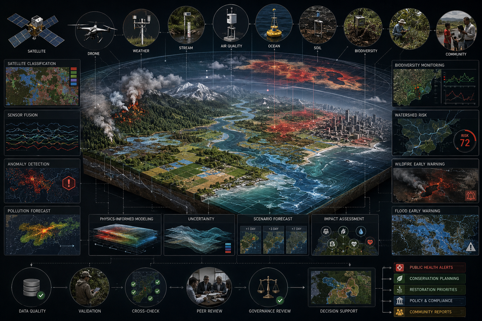
This article develops Artificial Intelligence in Environmental Monitoring as an advanced article within the Artificial Intelligence Systems knowledge series. It explains environmental monitoring as a complex systems problem, sensor networks, Earth observation, remote sensing, environmental data pipelines, state estimation, representation learning, spatiotemporal forecasting, physics-informed AI, anomaly detection, early warning systems, uncertainty, validation, environmental justice, governance, and decision integration. Selected Python and R examples appear here, while the full GitHub repository contains expanded computational scaffolding for environmental sensor fusion, environmental stress scoring, anomaly detection, data-quality review, regional equity analysis, SQL metadata, governance documentation, and reproducible outputs.
Why AI Environmental Monitoring Matters
AI environmental monitoring matters because ecological and climate conditions are changing faster than many traditional monitoring institutions were designed to observe. Air-quality hazards can shift by the hour. Floods can develop quickly across watersheds. Wildfire smoke can travel across regions. Heat islands can expose neighborhoods unevenly. Biodiversity loss may proceed silently until ecological function is already degraded. Land-cover change can occur across large territories that are difficult to inspect manually. Ocean warming, drought, soil moisture stress, and atmospheric circulation all require observation at scales far beyond isolated field measurement.
Artificial intelligence can help by integrating observations across sensors, satellites, field surveys, historical datasets, and scientific models. It can classify land cover from imagery, detect anomalies in sensor streams, interpolate sparse observations, forecast environmental hazards, map exposure, support early warning systems, and prioritize human review. These capabilities can improve environmental science, public health, climate adaptation, conservation, disaster response, and infrastructure planning.
But AI also changes the politics of environmental visibility. What is monitored becomes more governable. What remains unmeasured may remain neglected. Communities with dense sensor coverage may receive attention, while data-poor places may be misread as low-risk. Satellite models may represent landscapes from above while missing local knowledge from below. Environmental AI therefore raises a central question: how can intelligent monitoring systems expand environmental understanding without turning uncertainty, opacity, or unequal data coverage into new forms of environmental injustice?
Observation \neq Understanding
\]
Interpretation: Environmental measurement becomes meaningful only when observations are interpreted through scientific knowledge, uncertainty analysis, spatial context, ecological relationships, and governance purpose.
| Environmental Context | Why Traditional Monitoring Is Not Enough | AI Monitoring Question | Governance Concern |
|---|---|---|---|
| Air quality | Pollution varies across time, weather, neighborhoods, sources, and exposure pathways. | Can sensor networks and models identify pollution events and unequal exposure? | Unequal monitoring coverage, public-health alerts, and environmental justice. |
| Water systems | Water quality and flow depend on rainfall, land use, infrastructure, ecology, and contamination events. | Can AI detect anomalies and prioritize review before harm spreads? | Sensor gaps, delayed laboratory confirmation, and public accountability. |
| Biodiversity | Species and habitats are unevenly observed and often difficult to measure directly. | Can models detect population trends, habitat loss, and ecological stress? | Sampling bias, charismatic-species bias, and conservation priorities. |
| Climate hazards | Flood, fire, drought, heat, and storm risks vary across space, time, and vulnerability. | Can AI support early warning and adaptation planning under uncertainty? | False confidence, unequal preparedness, and risk communication. |
| Land-cover change | Deforestation, urban expansion, wetland loss, and agricultural change occur across large territories. | Can Earth observation and AI detect change quickly and reliably? | Misclassification, enforcement risk, and local sovereignty. |
Note: AI becomes most valuable in environmental monitoring when scale, uncertainty, heterogeneity, and decision consequence are inseparable.
Environmental Monitoring as a Complex Systems Problem
Environmental monitoring is not merely the act of collecting measurements. It is a systems practice that connects observation, interpretation, forecasting, decision-making, and intervention. A sensor reading becomes meaningful only when it is placed within a larger context: location, time, instrument quality, baseline conditions, ecological relationships, physical mechanisms, uncertainty, and governance purpose.
Environmental systems are difficult to monitor because they are:
- nonlinear: small changes can produce disproportionate effects under threshold conditions;
- multiscale: local observations may be shaped by regional, continental, or global processes;
- coupled: atmosphere, water, land, biodiversity, infrastructure, and human activity interact;
- dynamic: baselines shift over seasons, years, decades, and climate regimes;
- partially observed: no monitoring system captures all relevant variables everywhere;
- uncertain: measurement error, model error, sampling bias, and unknown mechanisms remain persistent;
- governed: environmental data is used in policy, regulation, emergency response, conservation, and public accountability.
AI can help environmental monitoring systems detect patterns, interpolate missing observations, classify land cover, estimate pollution exposure, forecast hazards, identify anomalies, and integrate data across modalities. But AI cannot remove the need for scientific judgment. Environmental monitoring systems must remain connected to physical theory, ecological understanding, measurement protocols, community knowledge, and institutional accountability.
Environmental\ Monitoring = Measurement + Context + Uncertainty + Governance
\]
Interpretation: Monitoring becomes environmentally meaningful when data is connected to context, uncertainty, scientific interpretation, and decisions that can be reviewed.
| System Property | Meaning | AI Opportunity | Risk if Mishandled |
|---|---|---|---|
| Nonlinearity | Thresholds and feedbacks can amplify change. | Detect early warning signals and regime shifts. | Models may miss tipping points or rare events. |
| Multiscale structure | Processes operate from local to planetary scales. | Fuse local sensors with satellite and climate data. | Scale mismatch can produce misleading conclusions. |
| Coupling | Air, water, land, ecology, infrastructure, and society interact. | Model compound environmental risks. | Single-domain models can ignore cross-system effects. |
| Partial observability | Many conditions are hidden, sparse, or indirectly measured. | Estimate missing states and quantify uncertainty. | AI may make sparse evidence appear complete. |
| Governance use | Monitoring informs public decisions and institutional action. | Support early warning, enforcement, planning, and stewardship. | Opaque systems can weaken accountability. |
Note: Environmental AI should extend scientific monitoring without replacing domain knowledge, uncertainty communication, or public accountability.
Data Sources: Sensors, Remote Sensing, and Earth Observation
Environmental monitoring depends on heterogeneous data. AI systems must often combine data that differs in spatial resolution, temporal frequency, uncertainty, instrument design, calibration history, and scientific meaning.
| Data Source | Examples | Strengths | Limitations |
|---|---|---|---|
| In-situ sensors | Air-quality monitors, water-quality probes, soil sensors, weather stations. | Local, frequent, direct measurements. | Spatial gaps, calibration drift, maintenance failures. |
| Remote sensing | Satellite imagery, radar, lidar, multispectral and hyperspectral data. | Large spatial coverage and repeated observation. | Cloud cover, resolution limits, retrieval uncertainty. |
| Field surveys | Biodiversity counts, forest plots, wetland surveys, ecological sampling. | High interpretive value and ground truth. | Expensive, sparse, labor-intensive. |
| Scientific instruments | Ocean buoys, flux towers, stream gauges, climate observatories. | High-quality domain-specific measurements. | Limited coverage and specialized maintenance needs. |
| Administrative data | Permits, inspections, land-use records, emissions inventories. | Policy relevance and institutional context. | Reporting bias, inconsistent standards, lagged updates. |
| Citizen science | Species observations, local environmental reporting, low-cost sensors. | Broad participation and spatial reach. | Variable quality and sampling bias. |
Note: Environmental data fusion requires aligning observations across space, time, format, uncertainty, and physical meaning.
NASA Earthdata, Copernicus, national meteorological agencies, environmental protection agencies, research institutions, and global climate programs provide major sources of environmental data. The technical challenge is not only data access. It is data fusion: aligning measurements across space, time, format, uncertainty, and physical meaning.
Data\ Fusion \neq Data\ Aggregation
\]
Interpretation: Environmental data fusion requires scientific harmonization of scale, resolution, uncertainty, calibration, and meaning—not merely combining files into one dataset.
Environmental Data Pipelines and Observability
An environmental AI system requires a pipeline that turns observations into governed information. Raw environmental data may arrive as satellite scenes, sensor streams, field survey tables, station records, raster grids, netCDF files, geospatial vectors, laboratory measurements, or textual reports. These data streams must be cleaned, validated, harmonized, stored, modeled, and interpreted.
A mature environmental monitoring pipeline includes:
- data ingestion: receiving satellite, sensor, field, and administrative data;
- quality control: checking missingness, outliers, calibration, sensor drift, and unit consistency;
- geospatial alignment: mapping observations to coordinates, grids, regions, watersheds, or ecosystems;
- temporal alignment: reconciling hourly, daily, seasonal, annual, and decadal observations;
- feature engineering: deriving indices, anomalies, moving averages, exposure measures, and contextual variables;
- modeling: classifying, forecasting, interpolating, detecting anomalies, or estimating risk;
- uncertainty analysis: representing measurement error, model uncertainty, and scenario uncertainty;
- decision integration: delivering outputs to analysts, agencies, emergency managers, researchers, and communities;
- audit and governance: preserving data lineage, model versions, assumptions, and review decisions.
Environmental observability requires more than dashboards. It requires knowing which parts of the environment are visible to the monitoring system, which parts are under-measured, which observations are uncertain, and which communities or ecosystems may be missing from the data.
| Pipeline Stage | Function | Environmental Example | Governance Risk |
|---|---|---|---|
| Ingestion | Collect observations from multiple sources. | Satellite scenes, stream gauges, air sensors, field surveys. | Data gaps and undocumented source differences. |
| Quality control | Detect errors, outliers, missing values, and calibration problems. | Sensor drift, cloud contamination, unit mismatch. | Bad data becomes authoritative. |
| Alignment | Harmonize observations across space and time. | Watershed grids, daily averages, seasonal baselines. | Scale mismatch distorts risk. |
| Modeling | Classify, forecast, interpolate, or detect anomalies. | Flood risk, air-quality exposure, land-cover change. | Model uncertainty is hidden or misunderstood. |
| Decision integration | Connect outputs to review and action. | Alerts, enforcement, conservation, emergency response. | Models influence policy without accountability. |
Note: Environmental observability requires lineage, uncertainty, metadata, and governance—not only real-time data streams.
Raw\ Environmental\ Data \neq Governed\ Environmental\ Evidence
\]
Interpretation: Environmental data becomes evidence only when quality, calibration, provenance, uncertainty, context, and decision use are documented.
Representation Learning for Environmental Data
Environmental data is often high-dimensional. A single satellite image may contain millions of pixels across multiple spectral bands. A sensor network may produce continuous time series from hundreds or thousands of locations. A climate dataset may include atmospheric, oceanic, terrestrial, and cryospheric variables across global grids and decades of time.
Representation learning helps convert these raw data streams into useful environmental features. In remote sensing, convolutional neural networks can identify spatial patterns such as vegetation, water, urban form, burn scars, cloud structures, or land-cover transitions. In time-series monitoring, recurrent models and transformers can learn temporal dependencies. In networked environmental systems, graph models can represent watersheds, river networks, air-quality stations, habitat corridors, or infrastructure-environment dependencies.
Environmental representations must remain scientifically meaningful. A model that classifies land cover accurately but ignores seasonal variation, sensor calibration, cloud contamination, or ground-truth uncertainty may produce misleading outputs. Representation learning should therefore be paired with domain validation, uncertainty analysis, and data lineage.
| Data Type | Representation Challenge | AI Method | Scientific Caution |
|---|---|---|---|
| Satellite imagery | High-dimensional spatial and spectral data. | Convolutional neural networks, vision transformers, segmentation models. | Cloud cover, seasonal effects, resolution, and ground-truth uncertainty matter. |
| Sensor time series | Continuous readings with missingness and drift. | Sequence models, anomaly detection, state-space models. | Sensor failure can look like environmental change. |
| Watersheds and networks | Relational structure across rivers, gauges, pipes, and regions. | Graph models and spatial statistics. | Connectivity assumptions must match physical hydrology. |
| Biodiversity observations | Sparse, biased, and uneven observations. | Species distribution models, computer vision, occupancy models. | Sampling bias can distort ecological conclusions. |
| Climate grids | Large spatiotemporal fields across variables and scales. | Emulators, transformers, hybrid models, downscaling methods. | Historical relationships may shift under climate change. |
Note: Learned representations must be validated against environmental mechanisms, not only prediction accuracy.
Useful\ Representation = Predictive\ Signal + Scientific\ Meaning
\]
Interpretation: Environmental representations should support prediction while preserving physical, ecological, and measurement meaning.
Spatiotemporal Modeling and Forecasting
Environmental monitoring is fundamentally spatiotemporal. Air pollution moves across neighborhoods and regions. Water quality changes along rivers and through watersheds. Drought develops across seasons. Wildfire risk depends on vegetation, weather, ignition, land management, and climate. Biodiversity changes across habitats, migration routes, and disturbance gradients.
AI systems support spatiotemporal modeling through:
- convolutional models: spatial pattern recognition in gridded imagery;
- recurrent and sequence models: temporal forecasting from time series;
- transformer models: long-range temporal and spatial dependencies;
- graph neural networks: relational structure across sensors, watersheds, transport pathways, or ecosystems;
- Gaussian processes and Bayesian models: uncertainty-aware spatial interpolation and prediction;
- ensemble models: multiple predictions for uncertainty and robustness.
Forecasting becomes most valuable when it is tied to action. A pollution forecast can support health alerts. A flood forecast can trigger emergency preparation. A drought forecast can inform water allocation. A biodiversity model can guide conservation priorities. The model’s value depends on whether its outputs are accurate, timely, interpretable, calibrated, and usable in decision contexts.
| Environmental Process | Spatial Dimension | Temporal Dimension | Decision Use |
|---|---|---|---|
| Air pollution | Neighborhoods, regions, airsheds, transport pathways. | Hourly, daily, seasonal, event-driven. | Health alerts, exposure reduction, enforcement. |
| Flood risk | Watersheds, floodplains, drainage networks. | Storm events, seasonal rainfall, long-term climate shifts. | Emergency response, infrastructure planning, adaptation. |
| Wildfire risk | Vegetation, terrain, communities, ignition zones. | Weather windows, drought cycles, fire seasons. | Preparedness, evacuation planning, fuel management. |
| Biodiversity change | Habitats, corridors, protected areas, migration pathways. | Seasonal, annual, generational, disturbance-driven. | Conservation, restoration, protected area management. |
| Urban heat | Blocks, neighborhoods, land cover, building density. | Daily cycles, heat waves, climate trends. | Public health, cooling centers, tree canopy planning. |
Note: Environmental forecasts should be evaluated by their decision value as well as statistical performance.
Physics-Informed and Hybrid Environmental AI
Purely data-driven environmental models can detect patterns, but they may fail when conditions move beyond the training distribution. Climate change, land-use change, extreme events, and ecological regime shifts can make historical relationships less reliable. Hybrid models attempt to combine the flexibility of machine learning with the constraints of scientific knowledge.
Physics-informed and hybrid approaches include:
- machine learning models constrained by conservation laws;
- neural networks trained with differential-equation residuals;
- statistical emulators of expensive physical simulations;
- data assimilation systems that combine observations with physical models;
- hybrid forecasts that blend numerical weather prediction with machine learning correction;
- ecological models that combine mechanistic understanding with observed data.
The goal is not to replace environmental science with machine learning. The goal is to use machine learning to extend, accelerate, and refine scientific monitoring while preserving physical and ecological meaning. This distinction is essential for environmental governance, where decisions often depend on whether a model represents mechanisms or only correlations.
Machine\ Learning + Domain\ Science \gt Pattern\ Recognition\ Alone
\]
Interpretation: Environmental AI is strongest when data-driven models are constrained, checked, or interpreted through scientific knowledge.
| Hybrid Approach | Purpose | Environmental Example | Governance Value |
|---|---|---|---|
| Physics-informed loss | Penalize violations of known physical constraints. | Hydrology, atmospheric dynamics, heat transfer. | Improves scientific plausibility and extrapolation. |
| Data assimilation | Combine observations with process models. | Weather forecasting, ocean modeling, drought monitoring. | Balances measurement and theory. |
| Model emulation | Approximate expensive simulations with faster models. | Climate scenarios, flood simulation, atmospheric chemistry. | Supports scenario exploration and planning. |
| Mechanistic-ML hybrid | Use machine learning for uncertain subcomponents. | Ecosystem dynamics, species distributions, water quality. | Preserves scientific interpretability. |
| Residual correction | Use AI to correct systematic model errors. | Weather, pollution, or hydrological forecast bias correction. | Improves operational accuracy while retaining model structure. |
Note: Hybrid environmental AI should document where scientific assumptions end and learned approximation begins.
Anomaly Detection and Early Warning Systems
AI is especially useful for anomaly detection and early warning. Environmental monitoring systems must identify unusual conditions quickly enough for intervention. These may include pollutant spikes, algal blooms, deforestation, illegal discharge, sensor failures, wildfire ignition, flood risk, heat stress, drought onset, coral bleaching, disease spread, or ecosystem disturbance.
An early warning system requires more than an anomaly score. It must define:
- what constitutes an anomaly;
- which data streams are trusted;
- how uncertainty is represented;
- which thresholds trigger alerts;
- who receives alerts;
- how alerts are verified;
- what actions follow;
- how false alarms and missed events are reviewed.
False alarms can reduce trust. Missed events can cause harm. A serious environmental AI system must track both and learn from operational experience.
| Anomaly Type | Possible Signal | Potential Meaning | Review Requirement |
|---|---|---|---|
| Air pollution spike | Sudden particulate or ozone increase. | Industrial release, wildfire smoke, inversion, traffic event, sensor error. | Verify sensor health, weather context, and source patterns. |
| Water-quality anomaly | Turbidity, temperature, conductivity, or oxygen deviation. | Runoff, contamination, algal bloom, equipment fault. | Confirm with field or laboratory evidence. |
| Land-cover change | Satellite classification shift. | Deforestation, urban expansion, fire scar, seasonal vegetation change. | Check imagery quality, seasonality, and ground truth. |
| Biodiversity signal | Unexpected species absence or presence. | Population shift, migration change, sampling bias, observer error. | Review sampling effort and ecological context. |
| Climate hazard | Forecast deviation or threshold exceedance. | Flood, drought, heat, fire, storm, or compound event. | Connect alert to emergency decision pathways. |
Note: Anomaly detection should support investigation, not replace scientific and operational review.
Alert \neq Verified\ Event
\]
Interpretation: An environmental alert should trigger verification, context review, and response protocols before being treated as settled knowledge.
Applications Across Environmental Domains
AI-driven environmental monitoring spans many domains. Across these domains, the most important question is not whether AI can detect environmental patterns. It is whether monitoring systems improve environmental protection, public health, ecosystem resilience, and accountable decision-making.
| Domain | AI Monitoring Tasks | Decision Relevance | Key Risks |
|---|---|---|---|
| Climate systems | Downscaling, forecasting, anomaly detection, emissions estimation. | Adaptation planning, mitigation, risk assessment. | Scenario uncertainty and model overconfidence. |
| Air quality | Pollution forecasting, exposure mapping, source detection. | Public health alerts, regulation, urban planning. | Sensor gaps and unequal monitoring coverage. |
| Water systems | Quality prediction, flow forecasting, contamination detection. | Drinking water safety, watershed management, flood response. | Sparse sensors and delayed laboratory confirmation. |
| Biodiversity | Species identification, habitat mapping, population trend estimation. | Conservation planning, protected area management. | Sampling bias and charismatic-species bias. |
| Forests and land cover | Deforestation detection, burn-scar mapping, land-use classification. | Climate policy, enforcement, restoration. | Cloud cover, misclassification, political misuse. |
| Oceans and coasts | Sea-surface monitoring, harmful algal bloom detection, coastal risk. | Fisheries, adaptation, emergency management. | Limited ground truth and dynamic boundaries. |
| Agriculture and soils | Crop stress, soil moisture, drought monitoring, pest risk. | Food security, irrigation, land management. | Smallholder data gaps and commercial data control. |
| Disaster risk | Flood, fire, landslide, heat, and storm monitoring. | Early warning, evacuation, emergency response. | Latency, false alarms, unequal preparedness. |
Note: Environmental AI should be evaluated by its contribution to stewardship, public health, ecosystem resilience, and accountable decision-making.
Uncertainty, Calibration, and Validation
Environmental predictions are uncertain because environmental systems are partially observed, dynamically changing, and affected by interacting drivers. AI systems must quantify uncertainty instead of presenting model outputs as exact truth.
Validation should include:
- spatial validation: testing performance across regions, ecosystems, watersheds, and communities;
- temporal validation: testing across seasons, years, and extreme events;
- sensor validation: comparing model outputs against calibrated instruments and field measurements;
- cross-scale validation: comparing local observations with regional or satellite-derived estimates;
- event validation: evaluating performance on fires, floods, pollution spikes, droughts, storms, or ecological disturbances;
- equity validation: checking whether monitoring accuracy differs across communities or regions;
- calibration review: testing whether predicted probabilities match observed event frequencies.
Environmental AI should be especially cautious during rare events and changing baselines. A model trained on past conditions may become unreliable under climate change, land-use transformation, or ecological regime shifts. In environmental monitoring, uncertainty is not a weakness to hide. It is a condition of responsible knowledge.
| Validation Type | Question | Evidence | Failure Mode |
|---|---|---|---|
| Spatial validation | Does the model work across places and ecosystems? | Regional, watershed, neighborhood, and habitat evaluation. | Aggregate accuracy hides local failure. |
| Temporal validation | Does the model work across seasons and event periods? | Seasonal, annual, and extreme-event tests. | Models fail under changing baselines. |
| Sensor validation | Are measurements reliable and calibrated? | Calibration records, field checks, instrument comparisons. | Sensor failure is mistaken for environmental change. |
| Cross-scale validation | Do local and remote observations agree? | Ground truth, satellite comparison, field verification. | Scale mismatch creates false certainty. |
| Equity validation | Does monitoring quality differ across communities? | Coverage maps, exposure analysis, environmental justice review. | Under-monitored areas remain invisible. |
Note: Responsible environmental AI treats uncertainty as evidence to communicate, not noise to conceal.
Uncertainty\ Communication = Scientific\ Integrity + Public\ Accountability
\]
Interpretation: Environmental monitoring systems should make uncertainty visible because public decisions depend on the limits of what is known.
Integration with Decision, Infrastructure, and Governance Systems
Environmental monitoring becomes consequential when it informs action. Data may flow into public health warnings, environmental enforcement, conservation planning, infrastructure operations, disaster response, water allocation, land-use planning, climate adaptation, or international reporting.
The monitoring-to-action pathway can be represented as:
Observe \rightarrow Model \rightarrow Forecast \rightarrow Decide \rightarrow Intervene \rightarrow Evaluate
\]
Interpretation: Environmental monitoring is part of a governance feedback loop. Observations inform models, models inform decisions, decisions shape interventions, and interventions must be evaluated through continued monitoring.
This feedback loop can improve environmental governance, but it can also create risks. If monitoring is uneven, decision systems may prioritize visible problems while neglecting under-measured communities or ecosystems. If models are proprietary or opaque, public accountability may weaken. If AI is used primarily for enforcement or surveillance without safeguards, environmental monitoring can become socially contested.
Responsible environmental AI must therefore connect technical performance to public purpose.
| Decision Context | Monitoring Output | Possible Action | Accountability Question |
|---|---|---|---|
| Public health | Pollution, heat, smoke, or water-quality alerts. | Warnings, shelter, filtration, closures, emergency response. | Are alerts timely, accessible, and equitable? |
| Environmental enforcement | Anomaly, discharge, land-cover, or emissions signal. | Inspection, investigation, compliance review. | Is the evidence reliable, contestable, and documented? |
| Conservation | Habitat loss, species trend, ecosystem stress. | Protection, restoration, management change. | Are local knowledge and ecological uncertainty included? |
| Infrastructure operations | Flood risk, water stress, heat stress, or wildfire exposure. | Maintenance, routing, capacity planning, emergency preparation. | Are risk burdens shifted or reduced? |
| Climate adaptation | Long-term exposure, vulnerability, and hazard projections. | Investment, relocation planning, resilience projects. | Who participates in defining adaptation priorities? |
Note: Environmental AI becomes governance infrastructure when its outputs shape public decisions.
Sustainability, Equity, and Global Environmental Governance
Environmental monitoring has global significance. Earth observation systems support climate science, biodiversity protection, disaster response, pollution regulation, conservation, water management, agriculture, public health, and sustainable development. AI can improve these systems by increasing coverage, speed, pattern detection, and forecasting capacity.
But environmental data and AI also raise governance questions:
- Who controls environmental data infrastructure?
- Which communities and ecosystems are monitored most closely?
- Which harms remain invisible because data is sparse?
- How are model assumptions disclosed?
- How can affected communities contest environmental classifications or risk scores?
- How are uncertainty and limitations communicated?
- How can global monitoring systems support local sovereignty and environmental justice?
AI-enabled environmental monitoring should be designed as public-interest knowledge infrastructure. Its purpose should be to improve environmental understanding, reduce harm, support stewardship, and strengthen accountable governance.
| Governance Area | Question | Evidence Needed | Risk if Ignored |
|---|---|---|---|
| Data control | Who owns, maintains, and governs environmental data? | Data licenses, institutional agreements, access policies. | Public-interest data becomes privatized or inaccessible. |
| Monitoring equity | Which places are visible and which remain under-measured? | Coverage maps, sensor distribution, community review. | Invisible harms are treated as low risk. |
| Scientific validity | Are model assumptions and uncertainty documented? | Validation reports, calibration records, model cards. | Predictions become authoritative without review. |
| Contestability | Can affected communities challenge outputs? | Public explanation, review process, appeal mechanisms. | Environmental classifications become unchallengeable. |
| Stewardship | Does the system support ecological and social responsibility? | Decision logs, outcomes evaluation, restoration tracking. | Monitoring becomes surveillance rather than care. |
Note: Environmental monitoring should strengthen public knowledge, ecological stewardship, and justice—not only institutional surveillance capacity.
More\ Monitoring \neq Better\ Stewardship
\]
Interpretation: Monitoring improves stewardship only when evidence is scientifically valid, publicly accountable, ethically governed, and connected to meaningful action.
Limits and Risks
AI in environmental monitoring has serious limits.
First, monitoring coverage is uneven. Some regions, ecosystems, and communities are heavily monitored, while others remain data-poor. AI can amplify visibility gaps if it treats sparse data as evidence of low risk.
Second, models can mistake correlation for mechanism. Environmental systems are causal, physical, and ecological systems. A predictive pattern may not represent a stable mechanism, especially under climate change or land-use transformation.
Third, remote sensing has retrieval uncertainty. Satellite-derived variables are not direct truth. They depend on instruments, atmospheric correction, algorithms, resolution, validation data, and processing assumptions.
Fourth, environmental AI can become opaque governance infrastructure. If models influence enforcement, conservation, disaster response, or resource allocation, their assumptions and limitations must be visible.
Fifth, global monitoring can create power asymmetries. Institutions with data infrastructure and modeling capacity may shape environmental narratives about places and communities that have less control over how they are represented.
The goal of AI-enabled environmental monitoring should be better stewardship, not merely more surveillance. The most useful systems will combine scientific rigor, open data, uncertainty communication, local knowledge, institutional accountability, and environmental justice.
Environmental\ Visibility \neq Environmental\ Justice
\]
Interpretation: Making environmental conditions visible is necessary but insufficient. Justice depends on who controls the data, how uncertainty is communicated, and whether evidence leads to protection, restoration, and accountability.
Mathematical Lens: Observation, State Estimation, and Spatiotemporal Forecasting
Environmental monitoring can be framed as a state-estimation problem. The true environmental state is only partially observed through sensors, satellites, and field measurements.
y_t = H x_t + \epsilon_t
\]
Interpretation: The observed measurement \(y_t\) is a partial and noisy observation of the true environmental state \(x_t\). The observation function \(H\) maps the state into what the monitoring system can measure, while \(\epsilon_t\) represents measurement error.
Environmental systems evolve over time according to physical, ecological, and human processes.
x_{t+1} = F(x_t, u_t, w_t)
\]
Interpretation: The future environmental state \(x_{t+1}\) depends on the current state \(x_t\), human or management action \(u_t\), and disturbance \(w_t\), such as weather, wildfire, flooding, drought, emissions, land-use change, or ecological shock.
AI models often learn a representation of raw observations.
z = f_{\theta}(x)
\]
Interpretation: A model \(f_{\theta}\) maps raw environmental input \(x\) into a learned representation \(z\). In satellite imagery, this may capture land-cover structure; in sensor networks, it may capture pollution, hydrological stress, or anomaly patterns.
Forecasting estimates future environmental values or risks.
\hat{y}_{t+k} = f_{\theta}(y_{1:t}, X_{1:t}, s)
\]
Interpretation: A forecasting model predicts a future environmental outcome \(\hat{y}_{t+k}\) using past observations \(y_{1:t}\), covariates \(X_{1:t}\), and spatial location \(s\). This structure is common in air-quality, weather, flood, wildfire, and ecological forecasting.
Physics-informed machine learning adds scientific constraints to the loss function.
\mathcal{L} =
\mathcal{L}_{data}
+
\lambda \mathcal{L}_{physics}
\]
Interpretation: A hybrid model balances empirical fit with physical consistency. \(\mathcal{L}_{data}\) measures prediction error, while \(\mathcal{L}_{physics}\) penalizes violations of known scientific constraints. The parameter \(\lambda\) controls the weight given to physical consistency.
Anomaly detection identifies observations that deviate from expected behavior.
A(x_t) =
\frac{|y_t – \hat{y}_t|}{\sigma_t}
\]
Interpretation: An anomaly score \(A(x_t)\) compares the difference between observed value \(y_t\) and expected value \(\hat{y}_t\), scaled by uncertainty \(\sigma_t\). Large values may indicate pollution events, sensor failures, fires, floods, ecosystem disturbances, or other unusual conditions.
Environmental stress prioritization can combine hazard, exposure, vulnerability, data quality, and environmental justice.
Priority_i =
\alpha h_i +
\beta e_i +
\gamma v_i +
\delta q_i +
\rho j_i
\]
Interpretation: Monitoring priority for zone \(i\) may combine hazard \(h_i\), exposure \(e_i\), vulnerability \(v_i\), data-quality risk \(q_i\), and environmental justice priority \(j_i\). The weights should be documented, reviewed, and governed.
Variables and System Interpretation
| Symbol or Term | Meaning | Environmental Interpretation | AI System Relevance |
|---|---|---|---|
| \(x_t\) | Environmental state | True system condition at time \(t\). | Often only partially observed. |
| \(y_t\) | Observed measurement | Sensor, satellite, station, or field measurement. | Input to monitoring and forecasting models. |
| \(H\) | Observation function | How instruments observe the state. | Encodes measurement limits and retrieval structure. |
| \(\epsilon_t\) | Measurement error | Noise, calibration error, retrieval uncertainty. | Critical for validation and uncertainty analysis. |
| \(F\) | State transition function | Environmental dynamics over time. | Used in forecasting and simulation. |
| \(u_t\) | Human or management action | Policy, restoration, emergency response, emissions control. | Connects monitoring to intervention. |
| \(w_t\) | Disturbance | Weather, fire, flood, drought, pollution, land-use shock. | Source of uncertainty and risk. |
| \(s\) | Spatial location | Coordinate, grid cell, watershed, region, ecosystem. | Required for spatial modeling and environmental justice review. |
| \(z\) | Learned representation | Latent pattern extracted from data. | Used in deep learning, remote sensing, and sensor fusion. |
| \(\mathcal{L}_{data}\) | Data loss | Prediction error against observations. | Measures empirical fit. |
| \(\mathcal{L}_{physics}\) | Physics loss | Penalty for violating physical constraints. | Supports hybrid scientific modeling. |
| \(A(x_t)\) | Anomaly score | Deviation from expected environmental behavior. | Used in early warning and event detection. |
Note: Environmental AI variables should be interpreted through measurement science, ecological context, uncertainty, and governance purpose.
Worked Example: AI for Watershed and Air-Quality Monitoring
Consider a regional monitoring system that combines river sensors, air-quality monitors, weather stations, satellite vegetation indices, land-cover maps, and industrial permit data. The goal is to detect environmental stress events and prioritize human review.
The system receives:
- hourly particulate matter readings from air-quality sensors;
- water temperature, turbidity, dissolved oxygen, and conductivity from river sensors;
- precipitation and temperature from weather stations;
- vegetation and land-surface indicators from satellite imagery;
- land-use and permit records from administrative sources;
- community exposure indicators for environmental justice review.
An AI model estimates an environmental stress score for each monitoring zone. The score combines anomaly detection, forecast deviation, sensor reliability, exposure, and ecological vulnerability. A governance-ready output should include:
- stress probability;
- anomaly score;
- sensor quality score;
- primary contributing variables;
- recent trend direction;
- uncertainty score;
- affected population or ecosystem estimate;
- environmental justice flag;
- recommended review or response action.
This example illustrates why environmental AI must be multi-layered. A pollution spike may be a real event, a sensor malfunction, a weather-driven inversion, a wildfire plume, a local industrial release, or a data processing error. AI can prioritize attention, but scientific and institutional review remains essential.
| Output Field | Meaning | Why It Matters | Review Question |
|---|---|---|---|
| Stress probability | Estimated probability of environmental stress or event risk. | Supports prioritization and early warning. | Is the model calibrated for this region and season? |
| Anomaly score | Deviation from expected environmental behavior. | Identifies unusual conditions for investigation. | Could the anomaly reflect sensor failure or processing error? |
| Sensor quality score | Reliability of the underlying measurement stream. | Prevents false precision from weak data. | Is evidence strong enough for action? |
| Environmental justice flag | Indicator of unequal exposure, vulnerability, or under-monitoring. | Helps prevent visible places from monopolizing attention. | Are historically burdened communities adequately represented? |
| Human review requirement | Whether expert, agency, or community review is needed. | Preserves accountability under uncertainty. | Who verifies, communicates, and acts on the signal? |
Note: Environmental AI should prioritize review when risk, uncertainty, data-quality concerns, or justice concerns are high.
Environmental\ Priority \neq Hazard\ Score\ Alone
\]
Interpretation: Monitoring priority should include hazard, exposure, vulnerability, data quality, uncertainty, ecological consequence, and justice—not only the highest model score.
Computational Modeling
Computational modeling for environmental monitoring should produce artifacts that help scientists, agencies, communities, and decision-makers understand environmental conditions under uncertainty. A useful workflow should not merely output a prediction. It should generate reviewable evidence: stress probabilities, anomaly scores, data-quality risk, population exposure, environmental justice flags, region-level summaries, and human-review requirements.
A practical environmental AI workflow should answer several questions:
- Which zones show elevated environmental stress?
- Which observations are anomalous relative to expected conditions?
- Which results are weakened by poor sensor quality or sparse data?
- Which communities or ecosystems may be exposed?
- Which predictions require scientific or institutional review?
- Are environmental justice priority zones receiving adequate monitoring attention?
- Can outputs be audited after decisions are made?
| Artifact | Purpose | Governance Value |
|---|---|---|
| Monitoring input table | Documents sensor, satellite, exposure, and regional variables. | Supports traceability and review. |
| Environmental stress score | Estimates environmental risk or stress probability. | Supports prioritization and early warning. |
| Anomaly score | Identifies deviations from expected environmental behavior. | Supports investigation and event detection. |
| Data-quality risk | Identifies weak or unreliable measurement streams. | Prevents false precision. |
| Equity review table | Compares monitoring outcomes across region types or priority zones. | Supports environmental justice review. |
| Governance summary | Summarizes zones reviewed, high-risk zones, review flags, and justice flags. | Supports audit, public reporting, and institutional accountability. |
Note: Environmental monitoring workflows should produce evidence for scientific review, community accountability, and public decision-making.
Python Workflow: Environmental Sensor Fusion and Risk Scoring
The following Python workflow creates a synthetic environmental monitoring dataset, fuses sensor and satellite-like features, estimates environmental stress risk, calculates anomaly scores, flags high-uncertainty or high-concern cases, and produces a governance-ready review table.
"""
Artificial Intelligence in Environmental Monitoring
Python workflow: environmental sensor fusion and risk scoring.

This example uses synthetic data so the workflow can be adapted to real
sensor, satellite, field, or administrative environmental datasets.
"""

from __future__ import annotations

from pathlib import Path

import numpy as np
import pandas as pd


RANDOM_SEED = 42
rng = np.random.default_rng(RANDOM_SEED)

OUTPUT_DIR = Path("outputs")
OUTPUT_DIR.mkdir(exist_ok=True)


def create_environmental_monitoring_data(n_zones: int = 120) -> pd.DataFrame:
    """
    Create synthetic environmental monitoring data by zone.

    In a production system, these variables could come from sensors,
    satellites, field surveys, administrative records, or exposure models.
    """
    zones = pd.DataFrame(
        {
            "zone_id": [f"Z{i:03d}" for i in range(n_zones)],
            "region_type": rng.choice(
                ["urban", "industrial", "agricultural", "forest", "coastal"],
                size=n_zones,
                p=[0.28, 0.16, 0.24, 0.20, 0.12],
            ),
            "pm25": rng.normal(14, 6, n_zones).clip(1),
            "ozone": rng.normal(52, 14, n_zones).clip(5),
            "water_turbidity": rng.normal(8, 4, n_zones).clip(0),
            "water_temperature": rng.normal(18, 5, n_zones).clip(0),
            "vegetation_index": rng.normal(0.55, 0.18, n_zones).clip(0, 1),
            "surface_temperature": rng.normal(24, 7, n_zones),
            "precipitation_anomaly": rng.normal(0, 1, n_zones),
            "sensor_health": rng.uniform(0.65, 1.00, n_zones),
            "population_exposure": rng.integers(100, 25000, n_zones),
            "environmental_justice_priority": rng.choice(
                [0, 1],
                size=n_zones,
                p=[0.72, 0.28],
            ),
        }
    )

    zones["industrial_or_urban"] = zones["region_type"].isin(
        ["urban", "industrial"]
    ).astype(int)

    zones["data_quality_risk"] = 1 - zones["sensor_health"]

    return zones


def estimate_environmental_stress(data: pd.DataFrame) -> pd.DataFrame:
    """
    Estimate environmental stress risk using interpretable synthetic scoring.

    The score combines air pollution, water stress, vegetation stress,
    climate anomaly, urban or industrial context, and data-quality risk.
    """
    scored = data.copy()

    scored["air_pollution_index"] = (
        0.55 * (scored["pm25"] / scored["pm25"].max())
        + 0.45 * (scored["ozone"] / scored["ozone"].max())
    )

    scored["water_stress_index"] = (
        0.60 * (scored["water_turbidity"] / scored["water_turbidity"].max())
        + 0.40 * (scored["water_temperature"] / scored["water_temperature"].max())
    )

    scored["vegetation_stress_index"] = 1 - scored["vegetation_index"]

    scored["climate_anomaly_index"] = (
        0.50
        * np.abs(scored["precipitation_anomaly"])
        / np.abs(scored["precipitation_anomaly"]).max()
        + 0.50
        * (scored["surface_temperature"] - scored["surface_temperature"].min())
        / (scored["surface_temperature"].max() - scored["surface_temperature"].min())
    )

    logit = (
        -2.8
        + 2.0 * scored["air_pollution_index"]
        + 1.6 * scored["water_stress_index"]
        + 1.4 * scored["vegetation_stress_index"]
        + 1.2 * scored["climate_anomaly_index"]
        + 0.6 * scored["industrial_or_urban"]
        + 0.8 * scored["data_quality_risk"]
    )

    scored["environmental_stress_probability"] = 1 / (1 + np.exp(-logit))

    scored["anomaly_score"] = (
        np.abs(scored["pm25"] - scored["pm25"].mean()) / scored["pm25"].std()
        + np.abs(scored["water_turbidity"] - scored["water_turbidity"].mean())
        / scored["water_turbidity"].std()
        + np.abs(scored["surface_temperature"] - scored["surface_temperature"].mean())
        / scored["surface_temperature"].std()
    ) / 3

    scored["human_review_required"] = (
        (scored["environmental_stress_probability"] > 0.60)
        | (scored["anomaly_score"] > 1.25)
        | (scored["data_quality_risk"] > 0.25)
        | (scored["environmental_justice_priority"] == 1)
    )

    scored["priority_score"] = (
        0.35 * scored["environmental_stress_probability"]
        + 0.20 * scored["anomaly_score"].clip(0, 2) / 2
        + 0.15 * scored["data_quality_risk"]
        + 0.15 * (scored["population_exposure"] / scored["population_exposure"].max())
        + 0.15 * scored["environmental_justice_priority"]
    )

    return scored.sort_values("priority_score", ascending=False)


def main() -> None:
    """Run environmental monitoring workflow and save governance artifacts."""
    data = create_environmental_monitoring_data()
    scored = estimate_environmental_stress(data)

    data.to_csv(OUTPUT_DIR / "environmental_monitoring_input.csv", index=False)
    scored.to_csv(OUTPUT_DIR / "environmental_stress_priority_table.csv", index=False)

    summary = pd.DataFrame(
        [
            {
                "zones_reviewed": len(scored),
                "mean_stress_probability": scored[
                    "environmental_stress_probability"
                ].mean(),
                "high_stress_zones": int(
                    (scored["environmental_stress_probability"] > 0.60).sum()
                ),
                "human_review_required": int(scored["human_review_required"].sum()),
                "environmental_justice_priority_zones": int(
                    scored["environmental_justice_priority"].sum()
                ),
                "mean_data_quality_risk": scored["data_quality_risk"].mean(),
            }
        ]
    )

    summary.to_csv(
        OUTPUT_DIR / "environmental_monitoring_governance_summary.csv",
        index=False,
    )

    top_review = scored[
        [
            "zone_id",
            "region_type",
            "environmental_stress_probability",
            "anomaly_score",
            "data_quality_risk",
            "population_exposure",
            "environmental_justice_priority",
            "priority_score",
            "human_review_required",
        ]
    ].head(10)

    top_review.to_csv(OUTPUT_DIR / "top_environmental_zones_for_review.csv", index=False)

    memo = f"""# Environmental Monitoring Governance Memo

## Summary

Zones reviewed: {len(scored)}
Mean environmental stress probability: {scored["environmental_stress_probability"].mean():.3f}
High-stress zones: {int((scored["environmental_stress_probability"] > 0.60).sum())}
Human review required: {int(scored["human_review_required"].sum())}
Environmental justice priority zones: {int(scored["environmental_justice_priority"].sum())}
Mean data-quality risk: {scored["data_quality_risk"].mean():.3f}

## Interpretation

- Environmental stress probability estimates zone-level environmental concern.
- Anomaly scores identify unusual observations for investigation.
- Data-quality risk identifies zones where measurement evidence may be weak.
- Environmental justice flags help prevent monitoring systems from overlooking
  communities with unequal exposure or historical under-monitoring.
- Human review should be required for high-risk, high-uncertainty, data-quality,
  or environmental justice-sensitive cases.
"""

    (OUTPUT_DIR / "environmental_monitoring_governance_memo.md").write_text(memo)

    print("Top environmental monitoring zones for review")
    print(top_review)

    print("\nGovernance summary")
    print(summary.T)

    print("\nGovernance memo")
    print(memo)


if __name__ == "__main__":
    main()
This workflow treats environmental monitoring as a governance and scientific-review problem, not only a prediction problem. Environmental stress probability, anomaly score, data-quality risk, population exposure, environmental justice priority, and human-review requirements are all preserved as reviewable evidence.
R Workflow: Environmental Trend and Equity Review
The following R workflow complements the Python example with trend analysis and environmental justice review. It simulates environmental monitoring zones, estimates stress risk, compares review rates by region type, and creates governance outputs.
# Artificial Intelligence in Environmental Monitoring
# R workflow: environmental trend and equity review.

set.seed(42)

if (!dir.exists("outputs")) {
  dir.create("outputs")
}

n <- 120

monitoring <- data.frame(
  zone_id = paste0("Z", sprintf("%03d", 1:n)),
  region_type = sample(
    c("urban", "industrial", "agricultural", "forest", "coastal"),
    size = n,
    replace = TRUE,
    prob = c(0.28, 0.16, 0.24, 0.20, 0.12)
  ),
  pm25 = pmax(rnorm(n, mean = 14, sd = 6), 1),
  ozone = pmax(rnorm(n, mean = 52, sd = 14), 5),
  water_turbidity = pmax(rnorm(n, mean = 8, sd = 4), 0),
  water_temperature = pmax(rnorm(n, mean = 18, sd = 5), 0),
  vegetation_index = pmin(pmax(rnorm(n, mean = 0.55, sd = 0.18), 0), 1),
  surface_temperature = rnorm(n, mean = 24, sd = 7),
  precipitation_anomaly = rnorm(n, mean = 0, sd = 1),
  sensor_health = runif(n, min = 0.65, max = 1.00),
  population_exposure = sample(100:25000, size = n, replace = TRUE),
  environmental_justice_priority = sample(
    c(0, 1),
    size = n,
    replace = TRUE,
    prob = c(0.72, 0.28)
  )
)

monitoring$industrial_or_urban <- ifelse(
  monitoring$region_type %in% c("urban", "industrial"),
  1,
  0
)

monitoring$data_quality_risk <- 1 - monitoring$sensor_health

monitoring$air_pollution_index <- 0.55 * (monitoring$pm25 / max(monitoring$pm25)) +
  0.45 * (monitoring$ozone / max(monitoring$ozone))

monitoring$water_stress_index <- 0.60 *
  (monitoring$water_turbidity / max(monitoring$water_turbidity)) +
  0.40 *
  (monitoring$water_temperature / max(monitoring$water_temperature))

monitoring$vegetation_stress_index <- 1 - monitoring$vegetation_index

monitoring$climate_anomaly_index <- 0.50 *
  abs(monitoring$precipitation_anomaly) /
  max(abs(monitoring$precipitation_anomaly)) +
  0.50 *
  (monitoring$surface_temperature - min(monitoring$surface_temperature)) /
  (max(monitoring$surface_temperature) - min(monitoring$surface_temperature))

logit <- -2.8 +
  2.0 * monitoring$air_pollution_index +
  1.6 * monitoring$water_stress_index +
  1.4 * monitoring$vegetation_stress_index +
  1.2 * monitoring$climate_anomaly_index +
  0.6 * monitoring$industrial_or_urban +
  0.8 * monitoring$data_quality_risk

monitoring$environmental_stress_probability <- 1 / (1 + exp(-logit))

monitoring$anomaly_score <- (
  abs(monitoring$pm25 - mean(monitoring$pm25)) / sd(monitoring$pm25) +
    abs(monitoring$water_turbidity - mean(monitoring$water_turbidity)) /
    sd(monitoring$water_turbidity) +
    abs(monitoring$surface_temperature - mean(monitoring$surface_temperature)) /
    sd(monitoring$surface_temperature)
) / 3

monitoring$human_review_required <-
  monitoring$environmental_stress_probability > 0.60 |
  monitoring$anomaly_score > 1.25 |
  monitoring$data_quality_risk > 0.25 |
  monitoring$environmental_justice_priority == 1

monitoring$priority_score <- 0.35 *
  monitoring$environmental_stress_probability +
  0.20 * pmin(monitoring$anomaly_score, 2) / 2 +
  0.15 * monitoring$data_quality_risk +
  0.15 * (monitoring$population_exposure / max(monitoring$population_exposure)) +
  0.15 * monitoring$environmental_justice_priority

priority_table <- monitoring[order(-monitoring$priority_score), ]

region_review <- aggregate(
  cbind(
    environmental_stress_probability,
    anomaly_score,
    data_quality_risk,
    human_review_required,
    environmental_justice_priority
  ) ~ region_type,
  data = monitoring,
  FUN = mean
)

governance_summary <- data.frame(
  zones_reviewed = nrow(monitoring),
  mean_stress_probability = mean(monitoring$environmental_stress_probability),
  high_stress_zones = sum(monitoring$environmental_stress_probability > 0.60),
  human_review_required = sum(monitoring$human_review_required),
  environmental_justice_priority_zones = sum(monitoring$environmental_justice_priority),
  mean_data_quality_risk = mean(monitoring$data_quality_risk)
)

write.csv(priority_table, "outputs/r_environmental_priority_table.csv", row.names = FALSE)
write.csv(region_review, "outputs/r_environmental_region_review.csv", row.names = FALSE)
write.csv(governance_summary, "outputs/r_environmental_governance_summary.csv", row.names = FALSE)

memo <- paste0(
  "# Environmental Trend and Equity Review Memo\n\n",
  "Zones reviewed: ", nrow(monitoring), "\n",
  "Mean environmental stress probability: ",
  round(mean(monitoring$environmental_stress_probability), 3), "\n",
  "High-stress zones: ",
  sum(monitoring$environmental_stress_probability > 0.60), "\n",
  "Human review required: ",
  sum(monitoring$human_review_required), "\n",
  "Environmental justice priority zones: ",
  sum(monitoring$environmental_justice_priority), "\n",
  "Mean data-quality risk: ",
  round(mean(monitoring$data_quality_risk), 3), "\n\n",
  "Interpretation:\n",
  "- The priority table ranks zones by stress probability, anomaly score, ",
  "data quality, exposure, and environmental justice priority.\n",
  "- The region review table compares monitoring outcomes across region types.\n",
  "- Human review should examine whether high-risk and under-monitored areas ",
  "are receiving adequate scientific and institutional attention.\n",
  "- Governance teams should document whether environmental AI improves ",
  "stewardship or merely increases surveillance capacity.\n"
)

writeLines(memo, "outputs/r_environmental_trend_equity_review_memo.md")

print("Top environmental monitoring zones for review")
print(head(priority_table, 10))

print("Region-level environmental review")
print(region_review)

print("Governance summary")
print(governance_summary)

cat(memo)
The R workflow is useful for governance review because it turns environmental modeling into interpretable tables: monitoring priority, region-level review, data-quality risk, environmental justice priority, and human-review requirements. These outputs can support scientific review, agency oversight, community accountability, and post-event evaluation.
GitHub Repository
The article body includes selected computational examples so the conceptual and mathematical argument remains readable. The full repository contains expanded computational infrastructure: advanced notebooks, Python and R workflows, SQL metadata, environmental monitoring schemas, sensor validation tools, scientific simulation examples, monitoring APIs, dashboard logic, edge-sensing examples, governance documentation, and reproducible outputs.
Complete Code Repository
The full code distribution for this article includes Python, R, SQL, Julia, environmental sensor fusion, remote-sensing workflow scaffolding, environmental stress scoring, anomaly detection, data-quality diagnostics, environmental justice review, governance documentation, reproducible outputs, and audit scaffolding for studying artificial intelligence in environmental monitoring.
From Automated Monitoring to Governed Environmental Intelligence
Artificial intelligence in environmental monitoring shows that intelligence is not only prediction, classification, or automation. It is a way of organizing environmental evidence across instruments, ecosystems, models, uncertainty, public institutions, and affected communities. The strongest environmental AI systems will not simply detect patterns faster. They will help societies understand environmental change, respond to hazards, protect ecosystems, reduce exposure, and govern uncertainty honestly.
The central lesson is that environmental monitoring must be governed. Sensors, satellites, machine learning models, dashboards, anomaly scores, and forecasts are powerful only when they are scientifically validated, calibrated, interpretable, equitable, and accountable. A model may detect land-cover change but misclassify seasonal variation. A pollution forecast may support public health but fail in under-monitored neighborhoods. A global satellite system may improve climate knowledge while raising questions about local sovereignty and data control. Environmental intelligence depends not only on technical capacity, but on the purposes, constraints, and review mechanisms that shape its use.
The future of AI-enabled environmental monitoring will likely depend on hybrid systems that combine Earth observation, sensor networks, edge computing, physics-informed machine learning, ecological modeling, statistical uncertainty, public data infrastructure, and local knowledge. These systems will need to operate across multiple scales: sensor node and watershed, neighborhood and airshed, habitat and biome, city and coastline, regional climate and planetary system.
Within the Artificial Intelligence Systems knowledge series, this article belongs near AI Systems for Infrastructure and Smart Networks, AI Infrastructure: Data Pipelines, Compute, and Deployment Systems, Edge AI and Distributed Intelligence, AI Safety and System Reliability, Model Validation, Benchmarking, and Generalization Theory, Causal Inference and Experimental Design in AI Systems, and Data Governance, Provenance, and Lineage in AI Systems. It provides the environmental and Earth-observation layer for understanding how AI systems become part of scientific measurement, public risk assessment, and ecological stewardship.
The final point is ethical. Environmental monitoring is not just a technical capacity to see the planet more clearly. It is a public responsibility to decide what is measured, how uncertainty is communicated, whose knowledge counts, which harms are made visible, and what actions follow from evidence. AI can help make environmental change more observable, but stewardship begins when observation leads to care, repair, protection, and accountability.
Related Articles
- AI Systems for Infrastructure and Smart Networks
- AI Infrastructure: Data Pipelines, Compute, and Deployment Systems
- Edge AI and Distributed Intelligence
- AI Safety and System Reliability
- Model Validation, Benchmarking, and Generalization Theory
- Causal Inference and Experimental Design in AI Systems
- Data Governance, Provenance, and Lineage in AI Systems
Further Reading
- NASA Earthdata (n.d.) Your Gateway to NASA Earth Observation Data. Available at: https://www.earthdata.nasa.gov/
- NASA Earthdata (n.d.) Earth Observation Data and Artificial Intelligence. Available at: https://www.earthdata.nasa.gov/learn/earth-observation-data-basics/artificial-intelligence
- European Commission (n.d.) Copernicus: Earth Observation. Available at: https://defence-industry-space.ec.europa.eu/eu-space/copernicus-earth-observation_en
- European Space Agency (n.d.) Introducing Copernicus. Available at: https://www.esa.int/Applications/Observing_the_Earth/Copernicus/Introducing_Copernicus
- Intergovernmental Panel on Climate Change (2023) Climate Change 2023: AR6 Synthesis Report. Available at: https://www.ipcc.ch/report/ar6/syr/
- Rolnick, D. et al. (2019) ‘Tackling Climate Change with Machine Learning’. Available at: https://arxiv.org/abs/1906.05433
- Raissi, M., Perdikaris, P. and Karniadakis, G.E. (2019) ‘Physics-informed neural networks: A deep learning framework for solving forward and inverse problems involving nonlinear partial differential equations’, Journal of Computational Physics, 378, pp. 686–707. Available at: https://www.sciencedirect.com/science/article/pii/S0021999118307125
- Rasp, S. et al. (2020) ‘WeatherBench: A benchmark dataset for data-driven weather forecasting’, Journal of Advances in Modeling Earth Systems, 12(11). Available at: https://agupubs.onlinelibrary.wiley.com/doi/10.1029/2020MS002203
References
- European Commission (n.d.) Copernicus: Earth Observation. Available at: https://defence-industry-space.ec.europa.eu/eu-space/copernicus-earth-observation_en
- European Space Agency (n.d.) Introducing Copernicus. Available at: https://www.esa.int/Applications/Observing_the_Earth/Copernicus/Introducing_Copernicus
- Intergovernmental Panel on Climate Change (2023) Climate Change 2023: AR6 Synthesis Report. Available at: https://www.ipcc.ch/report/ar6/syr/
- NASA Earthdata (n.d.) Your Gateway to NASA Earth Observation Data. Available at: https://www.earthdata.nasa.gov/
- NASA Earthdata (n.d.) Earth Observation Data and Artificial Intelligence. Available at: https://www.earthdata.nasa.gov/learn/earth-observation-data-basics/artificial-intelligence
- Raissi, M., Perdikaris, P. and Karniadakis, G.E. (2019) ‘Physics-informed neural networks: A deep learning framework for solving forward and inverse problems involving nonlinear partial differential equations’, Journal of Computational Physics, 378, pp. 686–707. Available at: https://www.sciencedirect.com/science/article/pii/S0021999118307125
- Rasp, S. et al. (2020) ‘WeatherBench: A benchmark dataset for data-driven weather forecasting’, Journal of Advances in Modeling Earth Systems, 12(11). Available at: https://agupubs.onlinelibrary.wiley.com/doi/10.1029/2020MS002203
- Rolnick, D. et al. (2019) ‘Tackling Climate Change with Machine Learning’. Available at: https://arxiv.org/abs/1906.05433