
Last Updated May 14, 2026
The future of environmental monitoring systems will be shaped by the convergence of artificial intelligence, Earth observation, field sensing, interoperable data infrastructure, and environmental intelligence. Monitoring is no longer only a matter of collecting measurements from isolated stations, satellites, surveys, or field instruments. It is becoming a distributed evidence system that must connect planetary-scale observation with local ecological conditions, sensor networks, model outputs, institutional decisions, and public accountability. The decisive question is not simply whether environmental systems can produce more data. It is whether they can transform expanding streams of environmental observation into reliable, interpretable, interoperable, and actionable knowledge about a changing planet.
Environmental monitoring is entering a period in which observational capacity is expanding faster than institutional capacity to interpret, validate, govern, and use it well. Satellites generate continuous Earth observation records. Field sensors capture air, water, soil, biodiversity, and infrastructure conditions at high temporal resolution. Machine-learning models detect patterns that may be invisible to conventional analysis. Cloud-native geospatial systems make large datasets easier to discover and process. Yet these advances also create new risks: opaque models, uneven coverage, weak metadata, fragmented standards, calibration drift, automated misinterpretation, and decision systems that appear intelligent while remaining poorly accountable. The future of environmental monitoring therefore depends on building systems that are not only technologically advanced, but scientifically disciplined, socially legitimate, and institutionally usable.
The central challenge is to move from environmental data accumulation toward environmental intelligence. Environmental intelligence does not mean replacing scientific judgment with automated prediction. It means organizing observation, models, metadata, uncertainty, provenance, and governance so that environmental change can be detected, interpreted, contested, and acted upon with greater clarity. Artificial intelligence can help classify land cover, detect anomalies, fuse sensor and satellite data, forecast hazards, summarize monitoring signals, and prioritize human attention. Earth observation can extend visibility across oceans, forests, cities, watersheds, agricultural regions, and the atmosphere. Interoperability can allow heterogeneous systems to communicate across agencies, platforms, regions, and disciplines. But intelligence emerges only when these capabilities are joined through accountable architectures that preserve measurement meaning, uncertainty, context, and public purpose.
Main Library
Publications
Article Map
Environmental Monitoring
Related Topic
Artificial Intelligence
Related Topic
Data Systems
Related Topic
Embedded & Edge Systems
Future environmental monitoring systems will be judged by the integrity of the full evidence chain. The chain begins with observation, but it does not end with a measurement, image, index, dashboard, or model output. It continues through calibration, metadata, uncertainty assessment, data integration, interpretation, decision support, public communication, review, and institutional learning. A monitoring system that detects change but cannot explain uncertainty is weak. A satellite product that offers wide coverage but lacks ground validation is weak. An AI model that performs well on benchmark data but fails under shifting climate, land-use, or sensor conditions is weak. A platform that integrates many datasets without preserving provenance may appear sophisticated while weakening trust. The future belongs to monitoring systems that combine computational scale with scientific humility and governance discipline.
Engineering Problem
The engineering problem is how to design environmental monitoring systems that can integrate heterogeneous observations, artificial intelligence models, Earth observation products, field sensor streams, metadata standards, uncertainty estimates, and institutional decision workflows without losing scientific validity, spatial-temporal meaning, provenance, interpretability, or public accountability. Future monitoring systems must process more data, but they must also explain what those data mean, where they came from, how reliable they are, and what decisions they can responsibly support.
This problem is difficult because environmental systems are open, dynamic, multi-scale, and unevenly observed. Air pollution varies across neighborhoods and hours. Rivers respond to rainfall, land use, upstream discharge, infrastructure, and seasonal conditions. Biodiversity signals depend on sampling method, habitat structure, detection probability, and observer bias. Satellite imagery provides large-scale visibility but may be limited by clouds, revisit frequency, spatial resolution, sensor characteristics, or classification uncertainty. AI models may generalize poorly when environmental regimes shift. Field instruments may drift, fail, foul, lose power, or transmit incomplete data. Monitoring systems therefore need architectures that preserve observational meaning while operating across uncertainty, scale, and change.
A weak future monitoring system treats AI as a dashboard enhancement, Earth observation as a universal substitute for field evidence, or interoperability as a purely technical API problem. A strong system treats monitoring as a full-stack evidence infrastructure. It specifies what is observed, how it is measured, how it is validated, how data are fused, how uncertainty is represented, how models are governed, how decisions are supported, and how environmental knowledge remains contestable when used in policy, risk management, sustainability claims, or public communication.
| Engineering Tension | Why It Matters | Required Evidence |
|---|---|---|
| Scale versus validity | Large-scale observation can produce broad visibility while masking local measurement uncertainty or ground-truth limitations. | Validation datasets, calibration records, accuracy reports, uncertainty maps |
| Automation versus accountability | AI can accelerate interpretation but may obscure assumptions, training data limits, and failure conditions. | Model cards, audit logs, version records, performance drift reports |
| Integration versus provenance | Data fusion can improve insight while weakening traceability if lineage is not preserved. | Provenance graph, source registry, transformation log, data lineage metadata |
| Interoperability versus semantic ambiguity | Systems can exchange data syntactically while disagreeing about observed properties, units, quality flags, or spatial meaning. | Controlled vocabularies, schema mappings, unit standards, semantic validation |
| Speed versus reviewability | Real-time alerts may be useful only if the system preserves enough evidence to explain why a signal was escalated. | Event evidence package, alert rationale, threshold log, human review record |
| Coverage versus equity | Monitoring systems may serve well-instrumented regions while leaving marginalized or under-resourced communities less visible. | Coverage audit, equity gap assessment, community monitoring integration |
The practical question is therefore: can the monitoring system convert heterogeneous environmental observations into decision-useful intelligence while preserving measurement validity, uncertainty, provenance, interoperability, equity, and governance across the full lifecycle of environmental evidence?
Reference Architecture
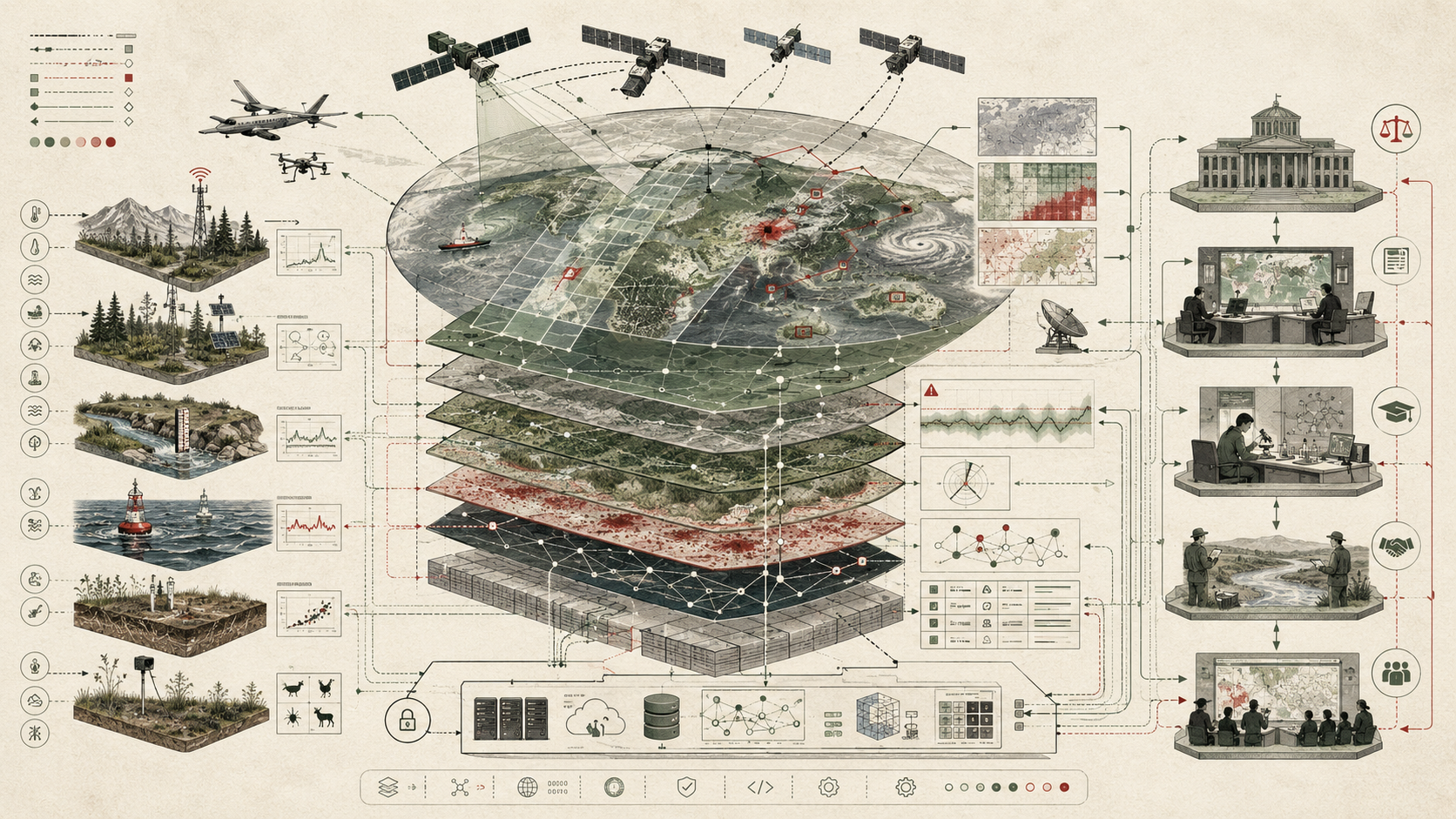
A future environmental monitoring architecture can be understood as a layered evidence stack. The exact implementation may involve satellites, aircraft, drones, in situ sensors, citizen science observations, environmental databases, cloud-native geospatial systems, AI models, edge gateways, APIs, dashboards, and policy workflows. The underlying responsibilities remain consistent: observation, calibration, metadata, integration, modeling, validation, interpretation, communication, governance, and learning.
| Layer | Engineering Role | Primary Risk | Evidence Artifact |
|---|---|---|---|
| Observation layer | Collects environmental signals from satellites, stations, sensors, surveys, models, and community observations. | Coverage gaps, sensor drift, sampling bias, inconsistent resolution | Observation inventory, station registry, satellite product catalog, sampling design |
| Calibration and quality layer | Maintains measurement validity through calibration, quality flags, uncertainty estimates, and anomaly checks. | Uncorrected drift, false precision, hidden missingness | Calibration ledger, QA/QC rules, uncertainty metadata, validation report |
| Metadata and semantics layer | Defines observed properties, units, spatial-temporal reference, methods, instruments, and lineage. | Semantic mismatch across systems | Metadata schema, controlled vocabulary, unit registry, provenance graph |
| Interoperability layer | Exposes observations and products through standardized APIs, catalogs, formats, and data-access patterns. | Fragmented access, brittle integrations, non-machine-actionable data | API specification, STAC catalog, SensorThings endpoint, data contract |
| Fusion and analytics layer | Combines Earth observation, field sensors, models, and contextual datasets into integrated indicators. | Unvalidated fusion, scale mismatch, loss of provenance | Fusion workflow, reproducible notebook, spatial join log, transformation manifest |
| AI and modeling layer | Detects patterns, classifies environmental states, forecasts risk, imputes gaps, and prioritizes attention. | Model opacity, bias, drift, overgeneralization | Model card, training data record, evaluation report, drift monitor |
| Decision-support layer | Transforms analytical outputs into thresholds, alerts, scenarios, dashboards, and institutional workflows. | Misinterpretation, poor communication, automation bias | Decision log, threshold registry, alert rationale, user guidance |
| Governance layer | Defines accountability, stewardship, access rights, review procedures, public communication, and ethical constraints. | Technocratic opacity, inequitable visibility, weak institutional review | Governance policy, access control matrix, audit report, community review record |
| Learning layer | Uses post-event review, model evaluation, field validation, and user feedback to improve the system over time. | Static systems that fail under changing environmental regimes | Retrospective analysis, error taxonomy, retraining record, improvement backlog |
This architecture makes the future of environmental monitoring visible as a system of evidence stewardship. AI and Earth observation are powerful only when embedded within architectures that can preserve measurement meaning, make uncertainty explicit, and support accountable interpretation. Interoperability is not merely the ability to move data between systems. It is the ability to move environmental evidence without destroying the context that makes that evidence scientifically and institutionally meaningful.
Implementation Pattern
A rigorous implementation begins by defining the environmental question, the observational domain, the spatial and temporal resolution, the acceptable uncertainty, the intended decision use, the relevant communities, the data sources, the model assumptions, the interoperability requirements, and the governance pathway. Engineers and researchers should specify not only what the system detects, but what evidence is sufficient to support interpretation and what limits must remain visible to users.
| Artifact | Purpose | Typical Format |
|---|---|---|
| Monitoring objective statement | Defines the environmental question, decision context, affected system, and intended users. | Markdown, policy brief, design record |
| Observation inventory | Lists sensors, satellite products, field observations, models, and contextual datasets. | CSV, JSON, YAML, database table |
| Metadata and semantics profile | Defines observed properties, units, spatial-temporal reference systems, methods, and quality flags. | JSON Schema, SensorThings model, controlled vocabulary, data dictionary |
| STAC or geospatial catalog | Makes Earth observation and raster/vector assets discoverable by time, space, and product metadata. | STAC JSON, API endpoint, catalog manifest |
| Sensor API contract | Exposes field observations through consistent query, metadata, and observation structures. | OGC SensorThings API, REST API, MQTT schema |
| Calibration and QA/QC policy | Defines sensor validation, quality flags, drift checks, missingness handling, and error thresholds. | YAML, SOP, test suite, validation report |
| Fusion workflow | Combines satellite, sensor, model, and contextual datasets while preserving lineage. | Python notebook, R Markdown, workflow DAG, pipeline script |
| AI model card | Documents model purpose, training data, limitations, evaluation domains, and known failure modes. | Markdown, YAML, registry record |
| Uncertainty report | Explains measurement uncertainty, model uncertainty, spatial uncertainty, and decision thresholds. | Notebook, HTML report, dashboard panel |
| Governance and access policy | Defines data stewardship, permissions, public release rules, community review, and ethical safeguards. | Policy document, access matrix, audit record |
| Operational monitoring plan | Tracks system health, data latency, sensor failures, model drift, API uptime, and evidence retention. | SLO document, telemetry dashboard, incident log |
The implementation goal is to make environmental intelligence inspectable. A user should be able to determine which observations were used, how they were processed, what assumptions shaped the model, how uncertainty was estimated, where the system performs well, where it should not be trusted, and how the output connects to a real environmental decision. Without that evidence discipline, future monitoring systems risk becoming high-volume instruments of low-confidence interpretation.
Research-Grade Framing: Environmental Intelligence as Accountable Observation
The most important conceptual shift is from monitoring as data collection to environmental intelligence as accountable observation. Environmental intelligence is not merely a larger dashboard, a faster model, or a more comprehensive satellite archive. It is the organized capacity to observe environmental change, integrate heterogeneous evidence, represent uncertainty, and support action while keeping the evidentiary chain open to review.
This distinction matters because environmental decisions are rarely based on direct measurement alone. They depend on interpreted signals. A land-use change map may combine satellite imagery, classification algorithms, training labels, field validation, and policy thresholds. A water-quality warning may combine sensor readings, calibration checks, hydrological context, historical baselines, and regulatory standards. A biodiversity indicator may combine sparse detections, modeled habitat suitability, species-distribution assumptions, and uncertainty about detection probability. Intelligence emerges only when the system can connect these components without pretending that uncertainty has disappeared.
Future monitoring systems should therefore be designed as evidence infrastructures rather than technology stacks. They must support scientific validity, operational reliability, machine readability, institutional accountability, and public contestability. AI can help discover patterns, but it cannot remove the need for calibration, ground truth, domain expertise, methodological transparency, and ethical governance. Earth observation can expand visibility, but it cannot eliminate the local knowledge needed to interpret environmental consequences. Interoperability can connect systems, but it cannot guarantee shared meaning unless semantics, metadata, and quality rules are aligned.
| Old Pattern | Future Pattern | Why the Shift Matters |
|---|---|---|
| Collect more observations | Collect decision-relevant observations with explicit uncertainty | Prevents data volume from substituting for evidence quality |
| Build dashboards | Build interpretable decision-support systems | Connects visualization to action, accountability, and review |
| Deploy AI models | Govern AI models across training, validation, drift, and use | Reduces opaque automation and domain shift failures |
| Integrate datasets | Preserve provenance across fusion workflows | Keeps outputs traceable to source observations and transformations |
| Publish data portals | Provide interoperable, machine-actionable, reusable evidence systems | Improves reuse, reproducibility, and cross-institutional coordination |
| Measure technical performance | Evaluate environmental, social, and institutional usefulness | Ensures monitoring systems serve real public and ecological needs |
A research-grade future for environmental monitoring must therefore remain skeptical of purely technological optimism. The goal is not to automate environmental truth. The goal is to build systems that make environmental change more visible, interpretable, reviewable, and actionable without erasing complexity, uncertainty, or unequal power.
Formal Model: Observation, Fusion, Intelligence, and Decision Usefulness
A useful formal model separates observations, data sources, models, uncertainty, interoperability, and decision usefulness. Let \(O_i\) represent observation source \(i\), \(Q_i\) represent its quality, \(U_i\) its uncertainty, \(S_i\) its spatial-temporal coverage, \(M_i\) its metadata completeness, and \(I_i\) its interoperability score. Let \(F\) represent a fusion process that combines multiple sources into an environmental intelligence product \(E\).
E = F(O_1, O_2, \ldots, O_n)
\]
Interpretation: Environmental intelligence products are derived from multiple observations, not from isolated measurements. The quality of the final product depends on the validity and compatibility of the sources being fused.
V_i = f(Q_i, S_i, M_i, I_i, 1 – U_i)
\]
Interpretation: The value of an observation source depends on measurement quality, coverage, metadata completeness, interoperability, and uncertainty. More data are not automatically better data.
U_E = g(U_1, U_2, \ldots, U_n, U_F, U_M)
\]
Interpretation: Uncertainty in an environmental intelligence product comes from source observations, fusion methods, and model assumptions. It should be carried forward rather than hidden in a final score.
D = h(E, U_E, C, T, G)
\]
Interpretation: A decision \(D\) depends not only on the environmental intelligence product \(E\), but also on uncertainty, context, timing, and governance. Monitoring outputs become useful only when they are interpreted within decision conditions.
R_{\mathrm{system}} = \alpha Q + \beta I + \gamma P + \delta A + \eta G – \lambda U
\]
Interpretation: System reliability can be approximated as a weighted combination of data quality \(Q\), interoperability \(I\), provenance \(P\), availability \(A\), governance \(G\), and uncertainty \(U\). The weights depend on domain and use case.
This formal lens helps prevent vague claims about AI-enabled monitoring. It shows that intelligence depends not only on model sophistication, but on observation quality, metadata, interoperability, provenance, uncertainty, and governance. A future monitoring system should be able to expose these dimensions rather than collapse them into a single unexplained output.
What Is the Future of Environmental Monitoring Systems?
The future of environmental monitoring systems is the development of integrated infrastructures that combine field observation, remote sensing, artificial intelligence, data standards, interoperable platforms, and decision workflows to understand environmental change across scales. These systems will monitor atmosphere, water, land, ecosystems, cities, agriculture, hazards, infrastructure, and climate-related risk. Their function will not be limited to recording conditions after the fact. They will increasingly support early detection, forecasting, adaptive management, compliance review, resilience planning, sustainability reporting, and public communication.
This future is already visible in the convergence of several technological and institutional trends. Earth observation platforms provide repeated measurements across large regions. Field sensor networks provide local and high-frequency evidence. Cloud-native geospatial systems make massive datasets more accessible. AI models support classification, anomaly detection, forecasting, gap filling, and decision triage. Standards such as geospatial APIs, sensor data models, and asset catalogs improve discovery and interoperability. Open-science and FAIR data principles encourage data systems that are findable, accessible, interoperable, and reusable. Global observing systems increasingly recognize the need to coordinate atmosphere, water, climate, ocean, land, and environmental data.
But the future should not be understood as a simple upward trajectory from manual monitoring to automated intelligence. Environmental monitoring is becoming more powerful and more fragile at the same time. Greater automation can amplify error if validation is weak. Greater data integration can produce false coherence if semantic differences are ignored. Greater spatial coverage can obscure local injustice if marginalized communities remain poorly measured. Greater model complexity can weaken accountability if assumptions are hidden. The future of environmental monitoring is therefore not only a technical frontier. It is a governance frontier.
Artificial Intelligence in Environmental Monitoring
Artificial intelligence will reshape environmental monitoring by expanding the ability to classify, detect, forecast, fuse, and prioritize environmental information. AI systems can identify land-cover change, detect deforestation, estimate water extent, classify clouds, identify pollution anomalies, forecast air quality, infer missing observations, detect sensor failures, estimate biodiversity patterns, and support early warning workflows. Foundation models and self-supervised methods may reduce the need for fully labeled datasets in some Earth observation tasks, while multimodal systems may combine optical imagery, radar, thermal data, time-series measurements, text records, and contextual variables.
AI is especially valuable where environmental data are large, heterogeneous, and time-sensitive. A human analyst cannot manually inspect every satellite scene, sensor stream, acoustic recording, camera-trap image, or anomaly signal produced by modern monitoring systems. AI can act as an attention-allocation mechanism, identifying where human review is needed most. In this sense, the strongest use of AI may not be autonomous environmental judgment, but disciplined triage: helping institutions find signals, compare scenarios, identify uncertainty, and allocate scarce scientific and operational attention.
However, AI introduces distinctive risks. Models trained in one region, season, sensor regime, or ecological context may not generalize elsewhere. Remote-sensing models may confuse visually similar classes. Sensor-fusion models may hide the uncertainty of individual data sources. Forecasting models may degrade when climate regimes shift. Large models may produce confident outputs that users interpret as objective environmental fact. Future monitoring systems therefore need AI governance: model documentation, training data records, validation by domain, uncertainty reporting, drift monitoring, human review pathways, and explicit constraints on use.
| AI Function | Environmental Use | Required Safeguard |
|---|---|---|
| Classification | Land cover, habitat type, cloud masking, water extent, damage mapping | Ground validation, class-specific accuracy, confusion matrix, uncertainty map |
| Anomaly detection | Pollution spikes, sensor faults, algal blooms, wildfire signatures, illegal activity indicators | False-positive review, threshold documentation, event evidence package |
| Forecasting | Air quality, flooding, drought, heat, ecosystem stress, water demand | Backtesting, forecast skill metrics, scenario uncertainty, domain-shift monitoring |
| Data fusion | Combining satellite, field sensors, model outputs, and contextual data | Lineage preservation, uncertainty propagation, scale compatibility checks |
| Gap filling | Missing sensor readings, cloud-obscured imagery, sparse ecological observations | Imputation flags, confidence intervals, distinction between observed and inferred values |
| Decision triage | Prioritizing inspection, field sampling, alerts, or restoration actions | Human review, audit logs, transparent ranking criteria, equity assessment |
AI should therefore be treated as a component within environmental evidence systems, not as an independent source of authority. Its value depends on how it is trained, validated, monitored, constrained, and explained.
Earth Observation and Planetary-Scale Visibility
Earth observation is central to the future of environmental monitoring because it provides repeated, spatially extensive measurements of the planet’s atmosphere, oceans, land, cryosphere, vegetation, urban systems, and hazard conditions. Satellite and airborne observations can reveal changes that are too large, remote, dangerous, or expensive to observe through field methods alone. They make it possible to monitor deforestation, land degradation, agricultural conditions, urban expansion, flood extent, wildfire scars, snow and ice, sea surface conditions, air pollution proxies, and vegetation stress across large regions.
The strength of Earth observation is scale. It can provide consistent measurement over regions that cross administrative boundaries and over time periods that support trend analysis. It can expose environmental change that would otherwise remain invisible to local institutions or fragmented by jurisdiction. It can also support accountability by providing independent evidence about land cover, environmental damage, disaster impacts, and sustainability claims.
Yet Earth observation is not self-interpreting. Sensor characteristics, spatial resolution, revisit frequency, atmospheric correction, cloud cover, orbital constraints, spectral bands, classification methods, and validation data all shape what can be responsibly inferred. A satellite image is not the same as an environmental conclusion. Future systems must therefore connect Earth observation to field validation, metadata, uncertainty, and domain expertise. Planetary-scale visibility becomes valuable only when it remains connected to local ecological meaning and decision context.
| Strength | Monitoring Value | Limit That Must Be Managed |
|---|---|---|
| Large spatial coverage | Supports regional, national, and global environmental assessment. | Local conditions may remain unresolved or misclassified. |
| Repeated observation | Supports change detection, trend analysis, and monitoring continuity. | Temporal gaps can result from clouds, revisit limits, or data outages. |
| Multispectral and radar sensing | Enables vegetation, water, urban, moisture, and structure-related indicators. | Environmental interpretation depends on preprocessing and validation. |
| Independent visibility | Can support accountability where local reporting is weak or contested. | Remote indicators may not capture lived impacts or social vulnerability. |
| Cloud-native access | Allows large-scale analysis without downloading massive archives. | Requires computational literacy, metadata discipline, and cost awareness. |
The future of Earth observation in environmental monitoring will depend less on imagery alone than on integrated workflows that join imagery, in situ measurement, AI interpretation, uncertainty reporting, and public decision systems.
Field Sensing, Edge Monitoring, and Local Environmental Evidence
Field sensing remains essential because many environmental conditions cannot be adequately understood from orbit. Air quality near roads, water chemistry in streams, soil moisture at field scale, dissolved oxygen in lakes, acoustic biodiversity signals, infrastructure-related contamination, and microclimate variation often require local instruments. Future environmental monitoring will therefore combine Earth observation with dense, distributed, and sometimes community-operated field sensing.
Embedded and edge systems will play a larger role in this future. Sensors deployed in remote or harsh environments may need to filter data locally, detect anomalies, buffer observations during connectivity outages, conserve power, manage calibration routines, and transmit only selected summaries or priority events. Edge computing can reduce bandwidth, improve response time, and preserve local continuity, but it also introduces governance questions. What data are filtered before transmission? What evidence is lost? Which local decisions are authorized? How are firmware, calibration, and model updates controlled? How is sensor drift detected?
Local monitoring also matters for environmental justice. Communities facing pollution, flooding, heat, land degradation, or ecological loss may require monitoring systems that capture conditions at scales meaningful to them. Official networks can be sparse or poorly positioned relative to lived exposure. Future systems should therefore include methods for integrating community monitoring, low-cost sensors, participatory observation, and local knowledge without treating these sources as either automatically inferior or automatically equivalent to regulatory-grade instruments. Their value depends on calibration, context, transparency, and appropriate use.
| Responsibility | Technical Requirement | Governance Requirement |
|---|---|---|
| Measurement validity | Calibration, QA/QC, drift detection, maintenance records | Transparent quality categories and limits on interpretation |
| Local continuity | Power management, buffering, offline operation, local storage | Clear policy for missing data and outage reconstruction |
| Edge filtering | Local rules, anomaly detection, compression, selective uplink | Evidence retention and explanation of filtered records |
| Community observation | Usable instruments, training, metadata capture, validation workflows | Respectful data stewardship and community access to results |
| Operational security | Device identity, signed updates, tamper detection, secure telemetry | Accountability for maintenance, access, and incident response |
The future is not satellite versus sensor, expert versus community, or cloud versus edge. It is an integrated monitoring architecture in which each source contributes evidence at the scale where it is strongest.
Interoperability, Standards, and Environmental Data Infrastructure
Interoperability is one of the decisive requirements for future environmental monitoring. Environmental evidence is often distributed across agencies, instruments, platforms, jurisdictions, research groups, satellites, field networks, and data portals. Without interoperable systems, environmental knowledge remains fragmented. Data may exist but remain difficult to discover, interpret, combine, or reuse. Monitoring systems may become collections of isolated datasets rather than coherent infrastructures for environmental intelligence.
Interoperability has several levels. Syntactic interoperability allows systems to exchange data through compatible formats and APIs. Semantic interoperability ensures that systems share meaning about observed properties, units, methods, spatial references, temporal references, and quality flags. Organizational interoperability allows institutions to coordinate access, stewardship, standards, and responsibilities. Scientific interoperability allows datasets to be combined without violating assumptions about scale, uncertainty, sampling, or measurement method.
Future monitoring systems will rely heavily on standards and practices such as geospatial APIs, sensor data models, spatiotemporal asset catalogs, controlled vocabularies, persistent identifiers, machine-actionable metadata, and FAIR data principles. Standards do not eliminate scientific judgment, but they reduce avoidable friction. They make it easier to discover environmental data, query observations, connect sensor systems, run reproducible workflows, and preserve context across platforms.
| Layer | Question | Example Evidence |
|---|---|---|
| Syntactic | Can systems exchange data in readable formats? | API documentation, JSON schema, GeoJSON, NetCDF, Zarr, Cloud Optimized GeoTIFF |
| Semantic | Do systems mean the same thing by observed properties, units, and quality flags? | Controlled vocabulary, ontology mapping, unit registry, data dictionary |
| Spatial-temporal | Can datasets be aligned by location, time, resolution, and reference frame? | Coordinate reference system, timestamp standard, grid definition, temporal aggregation rule |
| Provenance | Can users trace outputs back to source observations and transformations? | Lineage metadata, transformation log, processing version, source registry |
| Organizational | Do institutions share responsibilities for access, stewardship, and update cycles? | Governance agreement, data stewardship policy, service-level objective |
| Scientific | Can datasets be combined without misleading inference? | Validation report, uncertainty propagation, scale compatibility assessment |
Interoperability should therefore be treated as a scientific and governance requirement, not merely a software convenience. A future monitoring system that can exchange data but cannot preserve meaning remains only partially interoperable.
Environmental Intelligence and Decision Support
Environmental intelligence is the translation of environmental evidence into usable situational understanding. It joins observation, analytics, modeling, uncertainty, context, and governance into outputs that can support decision-making. These outputs may include early warnings, risk maps, environmental indicators, sustainability metrics, restoration priorities, compliance signals, scenario analyses, vulnerability assessments, or public dashboards. The goal is not simply to inform, but to help institutions and communities act more responsibly under uncertainty.
Decision support requires a different standard than data publication. A dataset may be scientifically useful without being operationally actionable. A dashboard may be visually impressive without clarifying what users should do. A model output may be accurate on average while failing in high-risk edge cases. Environmental intelligence systems must therefore define their decision context explicitly. Who will use the output? What action might follow? What uncertainty is acceptable? What harms could result from false positives or false negatives? What groups are affected? What review process exists?
Future systems should avoid the trap of treating intelligence as a single score. Environmental conditions are multi-dimensional. A watershed may face drought risk, nutrient loading, habitat decline, flood exposure, and governance fragmentation at the same time. A city may face heat stress, air pollution, tree-canopy inequality, drainage limitations, and vulnerable populations. Environmental intelligence should preserve complexity while making it navigable. Good systems do not erase uncertainty; they help users understand which uncertainties matter for which decisions.
| Output | Decision Use | Required Context |
|---|---|---|
| Environmental indicator | Track condition, pressure, exposure, or progress over time | Definition, data source, uncertainty, baseline, interpretation limits |
| Risk map | Prioritize inspection, investment, protection, or response | Hazard, exposure, vulnerability, spatial resolution, confidence |
| Anomaly alert | Trigger investigation or protective action | Threshold, evidence record, false-alarm history, response protocol |
| Forecast | Prepare for future environmental stress or hazard | Forecast horizon, skill, assumptions, uncertainty range, update cycle |
| Scenario analysis | Compare future pathways, policies, or interventions | Scenario assumptions, model structure, sensitivity analysis |
| Public dashboard | Communicate environmental conditions and trends | Plain-language interpretation, accessibility, data freshness, caveats |
The future of environmental monitoring depends on whether decision-support systems can remain rigorous, transparent, and usable under real institutional conditions. The best systems will help users ask better questions, not merely consume more automated outputs.
Uncertainty, Provenance, Validation, and Model Trust
Uncertainty is not a defect in environmental monitoring. It is a structural feature of observing complex systems. Measurements have error. Sensors drift. Satellites see some properties indirectly. Models simplify. Sampling designs miss some places and times. Field validation is incomplete. Social and ecological systems change. A future monitoring system that hides uncertainty is less trustworthy than one that represents uncertainty honestly.
Provenance is equally important. Users need to know where data came from, how they were transformed, which version of a product was used, what model produced an estimate, what training data were involved, and what assumptions shaped the result. Without provenance, environmental intelligence becomes difficult to audit. This matters in public decision-making, litigation, compliance, disaster response, sustainability reporting, and scientific review. Evidence without lineage is fragile evidence.
Validation must be domain-specific. A land-cover model needs independent ground truth and class-specific accuracy assessment. A low-cost air-quality sensor needs calibration against reference instruments and correction for environmental conditions. A hydrological forecast needs backtesting across event types and seasons. A biodiversity model needs attention to detection probability and sampling bias. A monitoring system should not simply claim performance; it should specify where performance has been demonstrated and where it remains uncertain.
| Trust Dimension | Question | Evidence Artifact |
|---|---|---|
| Measurement trust | Are the observations valid for the intended use? | Calibration record, QA/QC flags, sensor maintenance log |
| Model trust | Has the model been evaluated in the domain where it is used? | Model card, validation report, domain-specific performance metrics |
| Fusion trust | Were heterogeneous sources combined without losing scale or uncertainty meaning? | Fusion workflow, uncertainty propagation, spatial-temporal alignment report |
| Provenance trust | Can outputs be traced to source observations and transformations? | Lineage graph, processing manifest, version registry |
| Operational trust | Is the system functioning reliably over time? | Latency report, uptime metrics, missingness dashboard, incident log |
| Decision trust | Are users given enough context to interpret and act responsibly? | Decision guide, threshold rationale, uncertainty explanation, review protocol |
Trustworthy environmental intelligence depends on making uncertainty and provenance visible at the point of use. A future system should not ask users to trust a model because it is advanced. It should show why the evidence is suitable, where it is limited, and how those limits affect decisions.
Governance, Equity, and Public Accountability
Environmental monitoring systems are governance systems because they shape what becomes visible, what is ignored, who receives warnings, which risks are measured, which communities are prioritized, and which institutions can claim authority. Monitoring is not politically neutral when it affects environmental enforcement, infrastructure investment, public health, climate adaptation, conservation, disaster response, or sustainability reporting.
Future systems must therefore address monitoring inequality. Some places are richly observed while others are sparse. Some environmental harms are measured continuously, while others are documented only after community pressure. Some populations have access to technical dashboards, while others receive delayed or inaccessible information. AI and Earth observation can help reduce gaps, but they can also reproduce them if training data, validation networks, institutional priorities, and access pathways remain unequal.
Public accountability requires that monitoring systems be explainable, reviewable, and contestable. Communities affected by environmental decisions should be able to understand what is being measured, how conclusions are drawn, what uncertainties exist, and how errors can be challenged. Data governance should clarify ownership, stewardship, access, privacy, consent where relevant, and the appropriate use of community-generated data. Environmental intelligence should strengthen public capacity, not merely concentrate interpretive authority in technical platforms.
| Governance Question | Why It Matters | Accountability Mechanism |
|---|---|---|
| Who decides what is monitored? | Monitoring priorities shape environmental visibility and policy attention. | Public consultation, risk assessment, equity review |
| Who controls access to data? | Access determines who can verify, challenge, or reuse environmental evidence. | Open data policy, tiered access, community data agreements |
| Who validates model outputs? | AI systems can produce misleading authority without domain review. | Independent validation, model audit, scientific peer review |
| Who is represented in monitoring coverage? | Uneven coverage can reproduce environmental injustice. | Coverage audit, vulnerability overlay, community-monitoring integration |
| Who can challenge conclusions? | Environmental evidence may affect rights, obligations, funding, enforcement, or public trust. | Appeal process, methodological transparency, evidence release |
| Who benefits from intelligence? | Advanced systems can serve institutions while remaining inaccessible to affected publics. | Plain-language communication, accessible dashboards, participatory review |
The future of environmental monitoring should therefore be measured not only by technical sophistication, but by whether it expands the ability of societies to see environmental harm, protect vulnerable communities, hold institutions accountable, and steward ecological systems responsibly.
Applications Across Environmental Domains
The convergence of AI, Earth observation, interoperability, and environmental intelligence will affect nearly every domain of monitoring. In air quality, integrated systems can combine fixed stations, low-cost sensors, satellite aerosol products, meteorology, traffic, and land-use data to estimate exposure patterns. In water systems, sensors, hydrological models, satellite observations, and watershed data can support flood risk, contamination detection, drought tracking, and ecosystem health. In biodiversity, acoustic sensors, camera traps, eDNA, habitat mapping, and species-distribution models can strengthen ecological observation while also raising questions about sampling bias and data interpretation.
Urban monitoring will increasingly connect heat, air pollution, stormwater, tree canopy, infrastructure, energy, and demographic vulnerability. Agricultural monitoring will integrate soil moisture, crop health, evapotranspiration, irrigation, weather, and land-management data. Coastal monitoring will combine sea-level records, storm surge models, shoreline change, habitat condition, and community exposure. Disaster monitoring will link hazard detection, early warning, response protocols, and post-event assessment. Climate monitoring will depend on long-term continuity across observations, models, indicators, and institutional commitments.
| Domain | Integrated Evidence Sources | Decision-Support Use |
|---|---|---|
| Air quality | Reference stations, low-cost sensors, satellites, meteorology, traffic, emissions inventories | Exposure mapping, alerting, enforcement support, environmental justice analysis |
| Water systems | Stream gauges, water-quality sensors, rainfall radar, satellites, watershed models | Flood warnings, contamination response, drought planning, watershed management |
| Biodiversity | eDNA, acoustic sensors, camera traps, field surveys, habitat maps, species models | Conservation prioritization, habitat restoration, species-risk assessment |
| Land use | Satellite imagery, cadastral data, field validation, land-cover models, planning records | Change detection, deforestation monitoring, urban growth analysis, policy review |
| Climate risk | Climate records, reanalysis, projections, hazard models, exposure and vulnerability data | Adaptation planning, infrastructure resilience, scenario analysis, risk communication |
| Disaster response | Hazard sensors, forecasts, satellites, communications systems, impact observations | Early warning, evacuation support, damage assessment, recovery prioritization |
Across these domains, the most important future capability will be integration without erasure: the ability to connect evidence sources while retaining the context, uncertainty, and limitations that make environmental intelligence trustworthy.
Common Failure Modes
Future environmental monitoring systems can fail in characteristic ways. The most obvious failure is technical: sensors fail, satellites have gaps, APIs break, models drift, dashboards lag, storage systems lose data, or pipelines process observations incorrectly. But deeper failures are often epistemic and institutional. A system may produce outputs that look precise but are not valid for the decision being made. It may merge datasets whose spatial or temporal assumptions do not align. It may treat AI-generated inference as equivalent to direct measurement. It may hide uncertainty because uncertainty is politically inconvenient.
Another major failure mode is automation bias. Users may trust environmental intelligence outputs because they are generated by advanced models or presented through polished interfaces. This can be dangerous when models perform unevenly across regions, seasons, sensor types, or ecological conditions. Future systems must therefore make uncertainty and review pathways visible, especially where decisions affect public health, land use, enforcement, emergency response, or vulnerable communities.
| Failure Mode | Consequence | Prevention |
|---|---|---|
| False coherence | Integrated data products appear consistent while masking incompatible sources. | Semantic validation, scale checks, provenance preservation |
| Model drift | AI performance degrades as environmental conditions or sensor regimes change. | Drift monitoring, periodic validation, retraining policy |
| Hidden uncertainty | Users interpret estimates as more certain than they are. | Uncertainty intervals, confidence maps, clear caveats |
| Coverage inequality | Some communities or ecosystems remain poorly observed. | Coverage audit, participatory monitoring, vulnerability overlay |
| Provenance loss | Outputs cannot be traced back to source observations or transformations. | Lineage records, workflow manifests, version control |
| Dashboard theater | Visual sophistication substitutes for decision usefulness. | User testing, decision-context design, plain-language interpretation |
| Automation without review | AI outputs trigger action without sufficient human or institutional oversight. | Human-in-the-loop workflows, escalation rules, audit logs |
The future of environmental monitoring will be shaped as much by avoiding these failures as by adopting new technologies. A system that is technically advanced but epistemically weak can produce faster misunderstanding at larger scale.
Deployment Readiness Gate
Before a future environmental monitoring system is used for policy, public alerts, sustainability claims, infrastructure decisions, enforcement, or high-stakes planning, it should pass a deployment readiness gate. This gate should test whether the system is scientifically valid, technically reliable, interoperable, transparent, governed, and fit for the decision context.
| Readiness Area | Required Question | Pass Evidence |
|---|---|---|
| Observation readiness | Are the measurements valid for the intended environmental question? | Sampling design, calibration records, QA/QC report |
| Data readiness | Are data discoverable, documented, machine-readable, and reusable? | Metadata profile, catalog endpoint, data dictionary, license |
| Interoperability readiness | Can systems exchange and interpret observations correctly? | API tests, schema validation, controlled vocabulary mapping |
| Model readiness | Has the model been validated for the intended domain and decision use? | Model card, evaluation report, uncertainty analysis, drift monitor |
| Decision readiness | Do users know what actions the output can and cannot support? | Decision guide, threshold rationale, false-positive/negative review |
| Governance readiness | Are accountability, access, review, and community impacts addressed? | Governance policy, access matrix, equity review, audit plan |
| Operational readiness | Can the system remain reliable over time? | SLOs, uptime monitoring, incident response plan, maintenance schedule |
This readiness gate prevents future monitoring systems from being deployed merely because they are technically impressive. The stronger standard is whether they are scientifically warranted, operationally robust, socially accountable, and useful for the decisions they claim to support.
Data and Configuration Artifacts
A reproducible environmental intelligence workflow should include explicit artifacts that describe the monitoring objective, data sources, transformations, models, uncertainty, governance, and outputs. These artifacts make the system easier to audit, reproduce, extend, and govern.
| Artifact | Purpose | Suggested Path |
|---|---|---|
| Observation source inventory | Documents satellite products, sensors, field datasets, models, and contextual variables. | data/observation_source_inventory.csv |
| Monitoring objective manifest | Defines the environmental question, decision context, resolution, and users. | config/monitoring_objective.yml |
| Metadata schema | Defines required fields for observations, units, methods, quality flags, and lineage. | schemas/environmental_observation.schema.json |
| Interoperability profile | Specifies API, catalog, and semantic interoperability requirements. | config/interoperability_profile.yml |
| AI model card | Documents training data, intended use, limitations, validation, and failure modes. | model_cards/environmental_intelligence_model_card.md |
| Uncertainty policy | Defines how measurement, model, and fusion uncertainty are represented. | config/uncertainty_policy.yml |
| Governance policy | Defines data stewardship, access, review, community accountability, and release rules. | governance/environmental_intelligence_governance.md |
| Validation report | Summarizes model performance, source quality, uncertainty, and readiness. | outputs/validation_report.md |
These artifacts help turn the article’s conceptual argument into a reproducible workflow. They make clear that future environmental monitoring is not just a narrative about AI and satellites, but an engineering practice grounded in evidence management.
Mathematical Lens: Coverage, Fusion, Uncertainty, Interoperability, and Usefulness
Several simple metrics can help evaluate future environmental monitoring systems. These metrics are not substitutes for domain expertise, but they make hidden design assumptions more explicit.
C_{\mathrm{coverage}} = \frac{A_{\mathrm{observed}}}{A_{\mathrm{target}}}
\]
Interpretation: Coverage measures the share of the target area that is meaningfully observed. A high coverage score should still be interpreted alongside resolution, frequency, and uncertainty.
F_{\mathrm{freshness}} = t_{\mathrm{now}} – t_{\mathrm{latest}}
\]
Interpretation: Freshness measures how old the latest usable observation is. For early warning, operational monitoring, and rapid response, stale data can be functionally misleading.
I_{\mathrm{interop}} = \frac{N_{\mathrm{standardized}}}{N_{\mathrm{total}}}
\]
Interpretation: Interoperability can be approximated as the share of data sources that conform to documented formats, APIs, metadata rules, and semantic mappings.
P_{\mathrm{provenance}} = \frac{R_{\mathrm{traceable}}}{R_{\mathrm{total}}}
\]
Interpretation: Provenance completeness measures the share of records that can be traced back to source observations, transformations, versions, and processing steps.
U_{\mathrm{decision}} = \phi(U_{\mathrm{measurement}}, U_{\mathrm{model}}, U_{\mathrm{fusion}}, U_{\mathrm{context}})
\]
Interpretation: Decision uncertainty combines measurement error, model uncertainty, fusion uncertainty, and contextual uncertainty. These dimensions should be visible in high-stakes outputs.
S_{\mathrm{usefulness}} = w_1 Q + w_2 C + w_3 F + w_4 I + w_5 P + w_6 G – w_7 U
\]
Interpretation: Decision usefulness can be modeled as a weighted function of quality, coverage, freshness, interoperability, provenance, governance, and uncertainty. The weights should reflect the monitoring domain and use case.
These equations are deliberately simple. Their value lies in forcing monitoring systems to document what they often leave implicit: how much is observed, how fresh the evidence is, how interoperable the system is, how traceable the outputs are, and how uncertainty affects decision usefulness.
Python Workflow: Environmental Intelligence Pipeline
A Python workflow for this article can demonstrate how future monitoring systems combine source inventories, observation quality scores, interoperability flags, provenance completeness, uncertainty estimates, and decision-usefulness metrics. The workflow should be simple enough to reproduce, but structured enough to represent a real monitoring architecture.
from dataclasses import dataclass
from typing import List
import pandas as pd

@dataclass
class ObservationSource:
    source_id: str
    domain: str
    source_type: str
    coverage_score: float
    freshness_score: float
    quality_score: float
    interoperability_score: float
    provenance_score: float
    governance_score: float
    uncertainty_score: float

def decision_usefulness(source: ObservationSource) -> float:
    """
    Estimate decision usefulness from monitoring-system qualities.
    Higher uncertainty reduces the final score.
    """
    weights = {
        "quality": 0.20,
        "coverage": 0.15,
        "freshness": 0.15,
        "interoperability": 0.15,
        "provenance": 0.15,
        "governance": 0.10,
        "uncertainty": 0.10,
    }

    return (
        weights["quality"] * source.quality_score
        + weights["coverage"] * source.coverage_score
        + weights["freshness"] * source.freshness_score
        + weights["interoperability"] * source.interoperability_score
        + weights["provenance"] * source.provenance_score
        + weights["governance"] * source.governance_score
        - weights["uncertainty"] * source.uncertainty_score
    )

sources: List[ObservationSource] = [
    ObservationSource("sat-landsurface-001", "land", "earth_observation", 0.95, 0.80, 0.82, 0.90, 0.88, 0.78, 0.22),
    ObservationSource("sensor-water-001", "water", "field_sensor", 0.55, 0.92, 0.76, 0.70, 0.65, 0.72, 0.30),
    ObservationSource("community-heat-001", "urban_heat", "community_observation", 0.40, 0.85, 0.62, 0.55, 0.58, 0.80, 0.38),
    ObservationSource("model-air-001", "air_quality", "ai_model", 0.75, 0.88, 0.79, 0.76, 0.70, 0.68, 0.28),
]

records = []
for source in sources:
    score = decision_usefulness(source)
    records.append({
        "source_id": source.source_id,
        "domain": source.domain,
        "source_type": source.source_type,
        "decision_usefulness": round(score, 3),
        "requires_review": score < 0.65 or source.uncertainty_score > 0.35
    })

df = pd.DataFrame(records)
print(df.sort_values("decision_usefulness", ascending=False))
This workflow models environmental intelligence as a governed evidence process rather than as a raw predictive output. The same pattern can be extended to real geospatial data, sensor streams, STAC catalogs, SensorThings endpoints, model registries, and dashboard outputs.
R Workflow: Monitoring Indicators and Uncertainty Reporting
An R workflow can support indicator reporting, uncertainty summaries, trend analysis, and reproducible environmental assessment. R is especially useful for statistical reporting, ecological analysis, uncertainty communication, and publication-quality tables.
library(dplyr)
library(readr)

monitoring_sources <- tribble(
  ~source_id, ~domain, ~quality, ~coverage, ~freshness, ~interoperability, ~provenance, ~uncertainty,
  "sat-landsurface-001", "land", 0.82, 0.95, 0.80, 0.90, 0.88, 0.22,
  "sensor-water-001", "water", 0.76, 0.55, 0.92, 0.70, 0.65, 0.30,
  "community-heat-001", "urban_heat", 0.62, 0.40, 0.85, 0.55, 0.58, 0.38,
  "model-air-001", "air_quality", 0.79, 0.75, 0.88, 0.76, 0.70, 0.28
)

indicator_summary <- monitoring_sources %>%
  mutate(
    evidence_strength = (
      0.20 * quality +
      0.20 * coverage +
      0.15 * freshness +
      0.15 * interoperability +
      0.15 * provenance -
      0.15 * uncertainty
    ),
    review_priority = case_when(
      uncertainty >= 0.35 ~ "High uncertainty review",
      evidence_strength < 0.60 ~ "Evidence-strength review",
      TRUE ~ "Routine monitoring"
    )
  ) %>%
  arrange(desc(evidence_strength))

print(indicator_summary)

write_csv(indicator_summary, "outputs/environmental_intelligence_indicator_summary.csv")
The purpose of this workflow is not to reduce environmental monitoring to a single score. It is to demonstrate how quality, coverage, freshness, interoperability, provenance, and uncertainty can be reported together so that users understand the evidence conditions behind an environmental indicator.
Systems Code: Sensors, Edge Devices, APIs, Geospatial Pipelines, and Automation
Future environmental monitoring systems are full-stack systems. They include field devices, edge gateways, cloud services, geospatial catalogs, APIs, databases, workflows, dashboards, and governance records. A serious companion repository should therefore include more than Python and R notebooks. It should include systems-oriented examples that show how monitoring evidence moves through devices, services, data stores, and analytical workflows.
| Language / Tool | Role in Companion Repository | Example Use |
|---|---|---|
| Python | Geospatial processing, AI workflow, validation, uncertainty analysis | STAC query, raster analysis, model evaluation, evidence scoring |
| R | Indicator reporting, uncertainty summaries, ecological statistics | Environmental report tables, trend summaries, confidence intervals |
| SQL | Observation registry, sensor records, model output tables, lineage queries | Environmental observation database schema |
| Go | Lightweight API and telemetry service | Monitoring ingestion endpoint or health-check service |
| Rust | Safe validation tools and CLI checks | Schema validation, provenance integrity checks |
| C / C++ | Embedded monitoring and low-level sensor examples | Field-device sampling loop, buffering, calibration routine |
| MicroPython | Low-power sensor prototyping | Environmental sensor node reading and telemetry publishing |
| TinyML | On-device anomaly or classification example | Local sensor anomaly detection before uplink |
| PYNQ / HDL | Hardware-accelerated or FPGA-oriented monitoring demonstrations | Streaming signal processing or edge inference prototype |
| Bash | Repository setup, validation, reproducible runs | Run workflows, generate outputs, validate manifests |
This breadth is appropriate because environmental monitoring is not only a data-science problem. It is also an embedded systems, networked infrastructure, geospatial computing, AI governance, and public decision-support problem.
Testing and Validation
Testing future environmental monitoring systems requires more than checking that code runs. It requires testing observation validity, metadata completeness, interoperability, model performance, uncertainty propagation, provenance integrity, and decision-context suitability. Tests should be built into the system from the beginning, not added after outputs are already being used.
| Test Type | Purpose | Example Test |
|---|---|---|
| Schema validation | Ensure observations contain required fields and valid units. | Validate JSON records against observation schema. |
| Metadata completeness | Ensure records include method, source, time, location, and quality flags. | Fail records missing observed property, unit, or provenance. |
| Calibration check | Detect expired calibration or likely sensor drift. | Flag sensors exceeding drift or maintenance thresholds. |
| Geospatial consistency | Ensure coordinate systems, extents, grids, and timestamps align. | Validate spatial joins and temporal aggregation rules. |
| Model validation | Evaluate performance against independent data. | Generate confusion matrix, error metrics, uncertainty report. |
| Provenance test | Ensure outputs can be traced to source data and transformations. | Verify every output has source IDs and processing version. |
| Decision-use test | Ensure outputs are appropriate for the intended decision. | Review threshold logic, false-positive/negative implications, user guidance. |
The strongest monitoring systems validate both the data pipeline and the decision pipeline. They ask not only “Is the result technically correct?” but also “Is this result fit for the decision someone is likely to make with it?”
Operational Signals and Monitoring-System Observability
Environmental monitoring systems themselves must be monitored. A system that observes the environment but cannot observe its own performance is operationally fragile. Future systems should track data latency, missingness, sensor health, calibration status, API uptime, model drift, catalog freshness, processing errors, governance review status, and user-facing data quality.
| Signal | Why It Matters | Failure Indicator |
|---|---|---|
| Data latency | Determines whether outputs are timely enough for operational use. | Latest observation older than freshness threshold |
| Missingness | Reveals gaps in coverage, telemetry, or processing. | Missing records by site, domain, or time window |
| Sensor health | Shows whether instruments are functioning reliably. | Battery, calibration, drift, connectivity, or maintenance warning |
| Model drift | Reveals degradation under changing conditions. | Error increase, distribution shift, confidence instability |
| API availability | Determines whether data products remain accessible. | Failed requests, slow response, broken catalog queries |
| Provenance completeness | Determines whether outputs remain auditable. | Records missing source ID, version, or transformation lineage |
| Governance review status | Shows whether models, datasets, and public outputs are being reviewed. | Expired review, unapproved model version, unresolved incident |
System observability is essential because environmental intelligence depends on trust over time. A monitoring system should make its own degradation visible before users unknowingly rely on stale, incomplete, invalid, or poorly governed outputs.
Trade-Offs in Future Monitoring Design
Future environmental monitoring systems will require difficult trade-offs. Higher spatial resolution may increase cost and processing burden. More frequent observation may produce more noise and greater validation demands. Local edge processing may reduce bandwidth but remove access to raw data if evidence retention is weak. AI automation may improve speed but reduce interpretability. Open data may strengthen public accountability but require careful attention to privacy, sensitive ecological locations, Indigenous data sovereignty, and misuse risks.
| Trade-Off | Benefit | Risk |
|---|---|---|
| High-resolution monitoring | Improves local visibility and exposure assessment. | Increases storage, processing, privacy, and validation demands. |
| Real-time analytics | Supports rapid detection and response. | Can reduce review time and amplify false alarms. |
| AI automation | Scales classification, anomaly detection, and forecasting. | Can obscure assumptions and produce domain-shift failures. |
| Open data release | Strengthens transparency, reuse, and accountability. | May expose sensitive ecological, community, or infrastructure information. |
| Edge filtering | Reduces bandwidth and supports offline operation. | May discard raw evidence needed for later review. |
| Integrated indicators | Helps users understand complex conditions. | Can hide uncertainty or political assumptions in composite scores. |
Good monitoring design does not eliminate trade-offs. It documents them, governs them, and makes them visible to users. Future systems should be explicit about what they optimize and what they sacrifice.
Engineer and Researcher Checklist
- Define the environmental question before selecting sensors, models, or platforms.
- Document the intended decision use and the consequences of false positives and false negatives.
- Maintain source inventories for satellites, sensors, field observations, models, and contextual data.
- Use metadata standards that preserve observed property, unit, method, location, time, quality, and provenance.
- Represent uncertainty visibly in maps, indicators, forecasts, alerts, and dashboards.
- Validate AI models by domain, geography, season, sensor type, and decision context.
- Preserve lineage across data fusion, preprocessing, model inference, and publication.
- Use interoperable APIs and catalogs where possible, but verify semantic compatibility.
- Monitor the monitoring system: latency, missingness, drift, uptime, calibration, and review status.
- Assess coverage and equity gaps, especially for vulnerable communities and under-observed ecosystems.
- Keep human review pathways for high-stakes or uncertain outputs.
- Treat environmental intelligence as accountable evidence, not automated certainty.
GitHub Repository
A companion repository for this article should translate the future environmental monitoring architecture into reproducible technical scaffolding. The repository should include source inventories, metadata schemas, AI model cards, uncertainty policies, validation scripts, environmental intelligence scoring examples, and systems-code stubs for sensor, edge, API, and geospatial workflows.
Where This Fits in the Series
This article functions as the capstone and horizon-setting article for the Environmental Monitoring Systems series. It connects the series’ major themes: atmospheric monitoring, water systems, hydrological risk, soil and agricultural sensing, biodiversity observation, ecosystem monitoring, land-use change, sensor networks, embedded field devices, edge computing, IoT architectures, remote sensing, satellite observation, environmental data platforms, dashboards, early warning, sustainability strategy, disaster detection, and resilience monitoring.
Its role is not to replace those more specific articles, but to show how they converge. The future of environmental monitoring systems will depend on whether these domains can be connected into accountable intelligence infrastructures. Air sensors, satellites, biodiversity surveys, dashboards, AI models, water-quality instruments, and early warning systems are not separate futures. They are components of a broader monitoring architecture whose purpose is to make environmental change visible, interpretable, and actionable without losing scientific rigor or public accountability.
Related articles
- Environmental Sensor Networks
- Environmental Data Platforms and Decision Support Systems
- Environmental Analytics and Monitoring Dashboards
- Remote Sensing Systems in Environmental Monitoring
- Satellite Observation and Earth System Monitoring
- Edge Computing in Environmental Monitoring
- IoT Architectures for Environmental Monitoring
- Monitoring Environmental Risk and Resilience
Further reading
- NASA Earthdata (2026) Artificial Intelligence in Earth Science Data Systems. Available at: https://www.earthdata.nasa.gov/about/ai-strategy
- NASA Earthdata (2026) Earth Observation Data and Artificial Intelligence. Available at: https://www.earthdata.nasa.gov/learn/earth-observation-data-basics/artificial-intelligence
- European Commission (2026) Copernicus: Earth Observation. Available at: https://defence-industry-space.ec.europa.eu/eu-space/copernicus-earth-observation_en
- Group on Earth Observations (2026) Earth Intelligence and Global Earth Observation. Available at: https://earthobservations.org/
- Open Geospatial Consortium (2026) OGC SensorThings API Standard. Available at: https://www.ogc.org/standards/sensorthings/
- Open Geospatial Consortium (2026) OGC API Standards. Available at: https://ogcapi.ogc.org/
- SpatioTemporal Asset Catalogs (2026) STAC Specification. Available at: https://stacspec.org/
- World Meteorological Organization (2025) Global Observing System. Available at: https://wmo.int/site/knowledge-hub/programmes-and-initiatives/global-observing-system-gos
References
- European Commission (2026) Copernicus: Earth Observation. Available at: https://defence-industry-space.ec.europa.eu/eu-space/copernicus-earth-observation_en (Accessed: 14 May 2026).
- Group on Earth Observations (2026) Earth Observations. Available at: https://earthobservations.org/ (Accessed: 14 May 2026).
- NASA Earthdata (2026) Artificial Intelligence in Earth Science Data Systems. Available at: https://www.earthdata.nasa.gov/about/ai-strategy (Accessed: 14 May 2026).
- NASA Earthdata (2026) Earth Observation Data and Artificial Intelligence. Available at: https://www.earthdata.nasa.gov/learn/earth-observation-data-basics/artificial-intelligence (Accessed: 14 May 2026).
- NASA Earthdata (2026) SpatioTemporal Asset Catalogs. Available at: https://www.earthdata.nasa.gov/about/esdis/esco/standards-practices/stac (Accessed: 14 May 2026).
- Open Geospatial Consortium (2026) OGC API Standards. Available at: https://ogcapi.ogc.org/ (Accessed: 14 May 2026).
- Open Geospatial Consortium (2026) OGC SensorThings API Standard. Available at: https://www.ogc.org/standards/sensorthings/ (Accessed: 14 May 2026).
- SpatioTemporal Asset Catalogs (2026) STAC Specification. Available at: https://stacspec.org/ (Accessed: 14 May 2026).
- Wilkinson, M.D., Dumontier, M., Aalbersberg, I.J. et al. (2016) ‘The FAIR Guiding Principles for scientific data management and stewardship’, Scientific Data, 3, 160018. Available at: https://www.nature.com/articles/sdata201618 (Accessed: 14 May 2026).
- World Meteorological Organization (2025) Global Observing System. Available at: https://wmo.int/site/knowledge-hub/programmes-and-initiatives/global-observing-system-gos (Accessed: 14 May 2026).
- World Meteorological Organization (2015) WMO Integrated Global Observing System. Available at: https://wmo.int/media/magazine-article/wmo-integrated-global-observing-system-wigos (Accessed: 14 May 2026).