
Last Updated May 14, 2026
Satellite observation and Earth system monitoring are orbital-scale infrastructures of planetary observability through which atmosphere, land, ocean, cryosphere, biosphere, and human-environment processes become repeatedly measurable as interacting parts of one coupled Earth system. They use space-based sensors, orbital geometries, retrieval algorithms, calibration chains, geospatial processing systems, and data-service infrastructures to transform reflected, emitted, and backscattered energy into evidence about weather, climate, hazards, ecosystems, land systems, ocean dynamics, ice change, atmospheric composition, and long-term planetary transformation. In this sense, satellite observation is not simply remote sensing from higher altitude. It is the systematic construction of planetary visibility: a way of observing Earth broadly enough, repeatedly enough, and coherently enough to treat environmental change not as a set of isolated local episodes, but as a structured, coupled, and evolving whole.
Earth-system monitoring poses a distinctive observational challenge because the planet is not composed of separate environmental compartments that can be understood in isolation. Atmospheric circulation shapes ocean dynamics; land cover alters water and carbon cycles; cryospheric change modifies albedo, sea level, and energy balance; fires, aerosols, clouds, vegetation, hydrology, infrastructure, agriculture, and settlement patterns interact across spatial and temporal scales. A river basin, smoke plume, drought field, sea-ice anomaly, marine heatwave, flood extent, or land-cover transition is never merely local in meaning, even when it is locally experienced. Satellite systems address this problem by widening environmental observation to regional, continental, oceanic, and planetary scales while preserving repeatable measurement across time.
The deeper significance of satellite observation lies in the fact that it changes the scale at which environmental evidence becomes governable. A ground station may show a condition; a satellite record can show whether that condition is part of a basin-scale hydrological anomaly, a synoptic storm field, a land-change trajectory, a sea-ice retreat pattern, an aerosol transport event, a vegetation-stress region, or a broader climate tendency. But this orbital view also carries an inferential burden. Satellites frequently observe radiances, reflectances, brightness temperatures, backscatter, waveform returns, and other physical signals rather than environmental states directly. Earth-system meaning is produced through retrievals, classifications, calibration chains, validation, models, continuity strategies, and cross-mission integration. Exceptional satellite monitoring therefore depends not only on powerful instruments, but on disciplined treatment of orbital geometry, revisit logic, proxy interpretation, product lineage, continuity across missions, and the difference between measuring a signal and understanding a coupled planetary process.
Main Library
Publications
Article Map
Environmental Monitoring
Related Topic
Data Systems
Related Topic
Artificial Intelligence
Related Topic
Risk & Resilience
Satellite observation is where environmental monitoring becomes planetary evidence infrastructure. It makes it possible to observe environmental processes across places, scales, and time horizons that no local network could fully capture alone. Yet orbital observation is never pure transparency. It is an engineered and interpretive chain: sensor design, orbit, wavelength, calibration, retrieval, validation, compositing, gridding, uncertainty characterization, data continuity, and service delivery all shape what the final Earth-system product can responsibly mean. The central question is not simply what satellites can see, but how orbital signals become trustworthy evidence for understanding a coupled and changing planet.
Engineering Problem
The engineering problem is how to design satellite observation and Earth-system monitoring systems that can convert orbital measurements into reliable environmental evidence while preserving calibration, geolocation, retrieval logic, uncertainty, mission continuity, cross-sensor comparability, and decision relevance. Satellites do not directly deliver Earth-system truth. They deliver measurements whose meaning depends on physical sensing, algorithmic interpretation, validation, temporal harmonization, and integration with in situ and model-based evidence.
This problem is difficult because satellite observation must resolve several tensions at once. A mission may need global coverage, but high spatial resolution reduces revisit frequency or increases data volume. A geostationary platform may provide continuous regional monitoring, but not full global coverage. A polar-orbiting system may provide repeated global observation, but not constant local watch. A radar instrument may observe through cloud and darkness but represent surface structure differently from optical sensors. An optical sensor may support land-cover and vegetation analysis but be limited by clouds, atmosphere, illumination, and surface reflectance. A climate data record may require continuity across decades, but individual missions have finite lifetimes, evolving instruments, calibration drift, and changing retrieval methods.
Weak satellite-monitoring systems treat orbital data products as self-explanatory environmental facts. Strong systems treat them as evidence chains. They ask what was measured, how it was calibrated, what retrieval algorithm produced the geophysical variable, how uncertainty was characterized, how the product was validated, what spatial and temporal scales apply, what continuity strategy connects missions, and what Earth-system claim the product can honestly support.
| Engineering Tension | Why It Matters | Required Evidence |
|---|---|---|
| Coverage versus resolution | Global or wide-area observation often trades against local spatial detail and data volume. | Spatial resolution, swath width, coverage map, product-use statement |
| Revisit versus continuity | Frequent revisit supports short-term monitoring, while climate records require long-term comparability. | Revisit interval, mission overlap, calibration record, continuity plan |
| Signal versus state | Satellites measure radiance, reflectance, backscatter, or waveform response; environmental states are retrieved or inferred. | Retrieval algorithm, validation report, uncertainty estimate, product documentation |
| Operational speed versus evidentiary depth | Near-real-time products support warning and response but may be less refined than science-quality products. | Latency class, processing level, quality flag, update policy |
| Mission specificity versus Earth-system integration | Individual missions observe particular variables, while Earth-system monitoring requires coupled interpretation. | Cross-mission registry, variable map, model assimilation pathway, integration workflow |
| Global visibility versus local explanation | Orbital products reveal broad pattern but may not resolve local mechanism or lived impact. | In situ validation, local context, uncertainty note, interpretation boundary |
| Public authority versus proxy uncertainty | Satellite products often carry institutional authority, but many are derived from proxy measurements. | Method transparency, confidence flags, source lineage, public caveats |
The practical question is therefore: can the satellite monitoring system preserve enough measurement, retrieval, validation, uncertainty, and continuity context that orbital products become trustworthy evidence rather than visually persuasive planetary abstractions?
Reference Architecture
A practical satellite observation architecture can be understood as a layered Earth-system evidence system. The exact implementation may involve spacecraft, instruments, ground stations, downlink systems, calibration workflows, geolocation pipelines, retrieval algorithms, atmospheric correction, cloud masking, gridding, compositing, product catalogs, APIs, data cubes, forecast assimilation, dashboards, climate data records, and public-service platforms. The underlying responsibilities remain consistent: acquire, calibrate, geolocate, retrieve, validate, harmonize, integrate, interpret, deliver, and learn.
| Layer | Engineering Role | Primary Risk | Evidence Artifact |
|---|---|---|---|
| Mission and orbit layer | Defines orbital geometry, revisit, coverage, altitude, inclination, swath, and mission purpose. | Observation design misaligned with environmental question. | Mission profile, orbit description, revisit map, coverage statement |
| Instrument layer | Measures reflected, emitted, or backscattered energy across optical, infrared, microwave, radar, lidar, or other sensing modes. | Sensor limitations hidden in downstream products. | Instrument specification, spectral bands, radiometric performance, calibration plan |
| Acquisition and downlink layer | Captures scenes or streams, stores data, downlinks to ground systems, and registers observation timing. | Data gaps, latency, missed acquisitions, downlink failure. | Acquisition log, latency report, scene inventory, downlink status |
| Calibration and geolocation layer | Corrects measurements, assigns geospatial location, records viewing geometry, and applies quality controls. | Radiometric or geometric errors propagate into products. | Calibration coefficients, geolocation QA, quality flags, processing level |
| Retrieval and product layer | Transforms orbital signal into geophysical variables, classifications, indices, anomalies, or thematic products. | Derived product mistaken for direct observation. | Retrieval algorithm, product guide, uncertainty layer, validation report |
| Continuity and harmonization layer | Links observations across time, sensors, missions, algorithms, and processing versions. | False trend caused by sensor or method change. | Cross-calibration record, mission overlap plan, time-series documentation |
| Integration and assimilation layer | Combines satellite products with in situ observations, models, forecasts, and other data systems. | Incompatible evidence sources merged without uncertainty or semantic review. | Assimilation workflow, source lineage, model card, integration manifest |
| Service and decision layer | Delivers products through APIs, portals, dashboards, warning systems, climate services, and decision-support tools. | User-facing clarity without evidentiary depth. | Service documentation, user guide, action logic, public caveat statement |
| Governance and accountability layer | Defines stewardship, product review, public communication, continuity planning, and evidentiary accountability. | Orbital products influence decisions without transparent method or limits. | Product governance policy, change log, validation protocol, public evidence package |
This architecture makes clear that satellite observation is not a single act of seeing. It is a chain of measurement, correction, derivation, integration, and interpretation. The quality of Earth-system intelligence depends on every layer.
Implementation Pattern
A rigorous implementation begins by defining the Earth-system question, target variable, mission type, orbital geometry, sensing mode, product level, temporal need, spatial resolution, latency requirement, validation strategy, uncertainty policy, continuity plan, and decision use. The goal is not simply to acquire satellite imagery. The goal is to produce evidence whose limitations and valid uses are explicit.
| Artifact | Purpose | Typical Format |
|---|---|---|
| Observation objective manifest | Defines the Earth-system variable, question, decision use, spatial scale, temporal scale, and intended users. | YAML, Markdown, mission analysis record |
| Mission and sensor inventory | Lists satellites, instruments, sensing modes, spectral bands, orbits, revisit intervals, and product families. | CSV, SQL table, metadata catalog |
| Product registry | Defines product level, variable, units, spatial grid, temporal cadence, algorithm version, uncertainty, and access endpoint. | CSV, JSON, STAC-style catalog, SQL table |
| Retrieval algorithm card | Documents how orbital signal is transformed into a geophysical variable or classification. | Model card, algorithm theoretical basis document, Markdown |
| Calibration and validation record | Preserves calibration state, validation datasets, benchmark results, and uncertainty characterization. | PDF, CSV, QA/QC report, validation notebook |
| Continuity plan | Defines mission overlap, cross-calibration, version management, and long-term product comparability. | YAML, governance plan, release note, climate-data-record documentation |
| Integration manifest | Documents how satellite products are combined with in situ data, models, or decision-support systems. | Workflow manifest, DAG, notebook, data lineage graph |
| Uncertainty and proxy policy | Defines how retrieved, modeled, classified, and proxy products are labeled and communicated. | YAML, user guide, product caveat policy |
| Decision-support specification | Maps products to forecasting, monitoring, planning, response, reporting, or public communication uses. | User-role matrix, dashboard specification, service design record |
| Product change log | Tracks algorithm, calibration, product-version, or mission changes that could affect interpretation. | Release notes, Git log, product history table |
The implementation goal is to make orbital evidence reproducible and interpretable. Users should be able to move from Earth-system claim back to product, from product back to retrieval, from retrieval back to measurement, and from measurement back to mission and sensor context.
Research-Grade Framing: Satellite Observation as Earth-System Knowledge Infrastructure
A research-grade understanding of satellite observation begins by treating it as Earth-system knowledge infrastructure rather than high-altitude measurement alone. Satellite systems determine which planetary processes become visible at large scales, how often they can be revisited, which wavelengths can be observed, how continuity is maintained across missions, and how orbital measurements are translated into products that can be used in forecasting, climate analysis, hazard response, ecosystem assessment, environmental governance, and public communication.
This gives satellite observation exceptional reach, but also makes it epistemically selective. It is extraordinarily strong at synoptic and repeated observation. It is often weaker at direct causal specificity. Satellites record physical signals—radiances, reflectances, emissivities, brightness temperatures, backscatter, waveform returns—from which environmental meaning must be derived through retrievals, classifications, models, validation, and interpretation. A satellite may show the thermal expression of land stress, the structure of a storm system, the extent of snow and ice, the greenness of vegetation, the brightness of clouds, or the roughness of an ocean surface, but the environmental significance of those observations depends on an interpretive chain that remains partly inferential.
Satellite observation therefore does not remove interpretation from environmental monitoring; it institutionalizes it. The satellite archive is not a raw mirror of the planet. It is a structured, calibrated, model-informed, continuously revised, and scientifically negotiated evidentiary system. Its power lies in making planetary-scale environmental change visible in systematic ways. Its discipline lies in preserving explicit awareness of the inferential distance between orbital signal and Earth-system claim.
| Limited Pattern | Stronger Pattern | Why the Shift Matters |
|---|---|---|
| Treat satellite imagery as visual evidence | Treat satellite products as calibrated, retrieved, validated, and versioned evidence | Prevents visually persuasive products from being overinterpreted. |
| Analyze individual images | Build time-series, anomaly, and continuity-aware products | Supports change detection and climate-relevant interpretation. |
| Use one sensor or mission in isolation | Integrate complementary missions, sensors, in situ data, and models | Improves Earth-system interpretation across domains. |
| Publish products without method context | Expose retrieval logic, uncertainty, validation, and product limits | Strengthens scientific credibility and public accountability. |
| Prioritize coverage alone | Balance coverage, revisit, resolution, latency, and valid use | Aligns observation design with decision context. |
| Assume global view implies complete knowledge | Identify proxy limits, representational gaps, and local validation needs | Protects against orbital overconfidence. |
The central research question is not “Can satellites observe the Earth?” but “What kind of Earth-system knowledge can be responsibly constructed from orbital evidence, and under what assumptions?”
Formal Model: Orbital Signal, Retrieval, Continuity, and Earth-System Claim
A useful formal model separates orbital measurement, retrieval, validation, continuity, uncertainty, and Earth-system interpretation. Let \(S_o\) represent orbital signal, \(G\) viewing geometry, \(C\) calibration state, \(R\) retrieval algorithm, \(V\) validation strength, \(U\) uncertainty, \(H\) harmonization across missions, and \(E\) Earth-system claim. The claim is not contained directly in the signal; it is produced through a chain of transformation and interpretation.
P_{\mathrm{geo}} = f(S_o, G, C, R)
\]
Interpretation: A geophysical product \(P_{\mathrm{geo}}\) is derived from orbital signal, viewing geometry, calibration, and retrieval logic. The product is not the raw measurement itself.
Q_{\mathrm{retrieval}} = g(C, V, U, A, D)
\]
Interpretation: Retrieval quality depends on calibration \(C\), validation \(V\), uncertainty \(U\), algorithm suitability \(A\), and domain conditions \(D\).
K_{\mathrm{continuity}} = \frac{N_{\mathrm{overlap\ and\ cross\ calibrated\ periods}}}{N_{\mathrm{mission\ transitions}}}
\]
Interpretation: Continuity strength measures whether mission transitions are supported by overlap, cross-calibration, and documented comparability.
R_{\mathrm{revisit}} = \frac{1}{\Delta t_{\mathrm{repeat}}}
\]
Interpretation: Revisit rate increases as the repeat interval decreases. It is central to monitoring fast-changing hazards, vegetation, water, atmosphere, and ice conditions.
C_{\mathrm{coverage}} = \frac{A_{\mathrm{observed}}}{A_{\mathrm{target}}}
\]
Interpretation: Coverage ratio measures how much of the target area is observed under usable conditions. Clouds, viewing geometry, orbit, sensor limits, and tasking constraints affect this value.
Q_{\mathrm{earth\ claim}} = w_1Q_{\mathrm{retrieval}} + w_2K_{\mathrm{continuity}} + w_3C_{\mathrm{coverage}} + w_4V_{\mathrm{in situ}} + w_5U_{\mathrm{visibility}}
\]
Interpretation: The quality of an Earth-system claim depends on retrieval quality, continuity, coverage, in situ validation, and uncertainty visibility. Orbital scale alone does not determine evidentiary strength.
This formal structure keeps the evidence chain visible. It distinguishes signal from product, product from claim, and broad coverage from strong interpretation. Satellite monitoring is most powerful when each transformation is documented and each claim is scaled to the evidence that supports it.
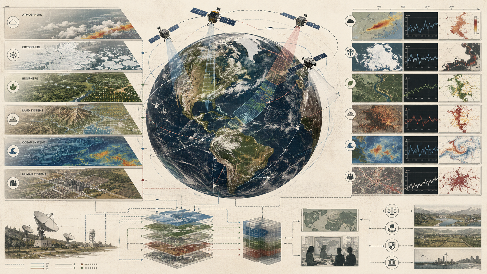
What Are Satellite Observation and Earth System Monitoring?
Satellite observation refers to the systematic use of space-based platforms to observe Earth’s atmosphere, land surface, ocean, cryosphere, biosphere, and environmental processes from orbit. Earth system monitoring is the broader practice of using those orbital observations—together with complementary observing systems and interpretive frameworks—to track the state, variability, and transformation of the coupled Earth system. Satellites are central to this effort because they offer repeated, large-scale, and often global observation that ground-based networks alone cannot sustain coherently.
Such systems may include polar-orbiting satellites for repeated global or near-global coverage; geostationary satellites for continuous regional observation; multi-mission constellations designed to observe complementary Earth-system variables; satellite instruments measuring visible, infrared, microwave, radar, lidar, altimetry, gravimetry, and related signals; processing pipelines that convert radiances and other measured signals into retrieved geophysical products; and global data and service systems linking satellite products to forecasting, research, early warning, public communication, and decision support.
The defining feature of satellite observation is planetary-scale repetition. Orbital systems do not merely offer a broad view; they produce structured, repeatable observation of Earth as a dynamic system. This makes them indispensable to Earth-system monitoring, where understanding depends not only on spatial scale but also on temporal continuity and the capacity to observe interactions among environmental spheres that would otherwise appear fragmented or disconnected.
| Function | Earth-System Role | Example Evidence |
|---|---|---|
| Atmospheric monitoring | Tracks weather systems, clouds, aerosols, water vapor, temperature, trace gases, and storm structure. | Cloud fields, atmospheric motion, lightning, aerosol optical depth, humidity, temperature profiles |
| Land monitoring | Tracks land cover, vegetation condition, surface temperature, fire, land-use change, and disturbance. | NDVI/EVI, land-cover maps, thermal anomalies, burn scars, urban expansion |
| Ocean monitoring | Tracks sea-surface temperature, ocean color, sea level, waves, winds, circulation, and marine productivity. | SST fields, chlorophyll products, altimetry, sea-surface height, ocean wind products |
| Cryosphere monitoring | Tracks sea ice, land ice, snow cover, glacier change, permafrost indicators, and albedo-related processes. | Sea-ice extent, snow cover, ice elevation, glacier velocity, melt indicators |
| Hazard monitoring | Supports flood, fire, drought, storm, landslide, volcanic, heat, and smoke observation. | Flood extent, fire hotspots, smoke plumes, storm imagery, drought anomalies |
| Climate monitoring | Builds long-term records of Earth-system variables and climate indicators. | Temperature, sea ice, clouds, radiation, ocean, land, and atmospheric records |
| Decision support | Connects orbital products to operations, planning, warning, regulation, and public evidence. | Dashboards, maps, APIs, climate services, hazard products, scenario tools |
Satellite observation becomes Earth-system monitoring when orbital records are not treated as isolated scenes, but as structured evidence about interacting planetary processes.
Why Satellite Observation Matters
Satellite observation matters because many environmental and climatic processes become intelligible only when seen at scales larger than any local observing network can provide. Cyclones, heat domes, ocean color fields, wildfire smoke plumes, sea-ice margins, flood extents, vegetation anomalies, atmospheric transport corridors, land-surface change, drought propagation, marine heatwaves, and snowpack patterns all extend beyond the horizons of local instrumentation. Satellite systems make these phenomena visible as coherent patterns rather than disconnected local traces.
It also matters because Earth-system change is not only spatially large but temporally structured. A single orbital image can reveal condition. A sequence of orbital observations can reveal persistence, acceleration, oscillation, disturbance, recovery, recurrence, and long-term trend. Climate monitoring in particular depends on records that persist beyond individual missions and support comparability across decades. Without this continuity, planetary change is harder to distinguish from episodic variability, sensor transition, or methodological revision.
Most importantly, satellite observation matters because it supports coupling across environmental domains. A drought is not merely a precipitation anomaly; it can involve land-surface heating, soil moisture depletion, vegetation stress, atmospheric circulation, groundwater pressure, and water-management response. A flood is not merely local inundation; it may connect rainfall fields, snowmelt, soil saturation, coastal conditions, impervious surfaces, river networks, and downstream exposure. Satellite systems are powerful because they help place local environmental conditions within larger Earth-system configurations and thereby transform isolated observations into systemic evidence.
| Need | Satellite Contribution | Risk Without Orbital Observation |
|---|---|---|
| Synoptic awareness | Shows broad environmental patterns across regions, continents, oceans, and hemispheres. | Large-scale dynamics remain fragmented across local observations. |
| Repeated observation | Supports change detection, anomaly analysis, and trend monitoring. | Environmental change is seen as disconnected episodes rather than trajectories. |
| Hazard response | Provides rapid views of storms, floods, fires, smoke, drought, ice, and heat conditions. | Warning and response systems lack wide-area situational awareness. |
| Climate continuity | Supports long-term records across missions when harmonized and calibrated. | Trend interpretation becomes vulnerable to mission discontinuity. |
| Earth-system coupling | Connects atmosphere, land, ocean, ice, and biosphere indicators. | Interactions among system components remain under-observed. |
| Public evidence | Makes planetary transformation more visible and harder to dismiss as isolated local events. | Environmental change remains anecdotal, localized, or institutionally invisible. |
Satellite observation matters because it changes the scale and continuity of environmental evidence. It allows monitoring systems to ask not only what is happening in one place, but how local conditions relate to wider planetary dynamics.
Orbits, Mission Types, and Observation Geometry
Satellite observation is shaped fundamentally by orbit and mission design. Geostationary systems maintain fixed regional watch, making them especially powerful for rapidly evolving atmospheric and environmental events. They privilege temporal continuity over full global reach. NOAA’s GOES satellites, for example, operate in geosynchronous orbit and can continuously monitor the same area of Earth, supporting intensive data analysis, storm observation, atmospheric measurements, lightning mapping, and space-weather monitoring.
Polar-orbiting and low-Earth-orbit systems, by contrast, trade constant local visibility for repeated global or near-global coverage. This makes them central to climate monitoring, land observation, ocean analysis, cryosphere monitoring, large-scale environmental mapping, and Earth-system data continuity. Some missions prioritize global coverage and spectral diversity; others prioritize radar imaging, altimetry, atmospheric profiling, gravimetry, thermal sensing, or high-resolution land monitoring. Mission purpose and orbit are therefore inseparable from the type of environmental evidence produced.
Mission types also differ by institutional role. Some are operational, designed to support forecasting and near-real-time services. Others are research missions aimed at advancing understanding of specific Earth-system variables or testing new observing capabilities. Others are coordinated constellations intended to observe complementary aspects of the Earth system. NASA’s Earth System Observatory reflects this integrative direction by emphasizing complementary missions that work together to create a more holistic view of Earth. Copernicus Sentinel missions similarly illustrate the value of mission families designed for operational monitoring needs, revisit requirements, and robust service datasets.
| Design Choice | Strength | Constraint | Typical Use |
|---|---|---|---|
| Geostationary orbit | Continuous regional monitoring and rapid updates. | Limited regional view and lower spatial detail than many low-Earth systems. | Weather, storms, lightning, atmospheric monitoring, nowcasting |
| Polar / low-Earth orbit | Repeated global or near-global coverage. | Less continuous local viewing between passes. | Climate records, land, ocean, ice, atmosphere, environmental mapping |
| Optical sensing | Rich land, vegetation, water, cloud, and surface-reflectance information. | Cloud, smoke, illumination, atmosphere, and shadow limitations. | Land cover, vegetation, water color, disturbance, urban change |
| Thermal infrared sensing | Surface and atmospheric temperature-related information. | Atmospheric effects and resolution tradeoffs. | Heat, fire, evapotranspiration, land-surface temperature, ocean temperature |
| Microwave / radar sensing | All-weather and day-night observation for many applications. | Interpretation depends on surface roughness, moisture, geometry, and scattering physics. | Floods, soil moisture, ice, deformation, vegetation structure, ocean surface |
| Altimetry / lidar / profiling | Vertical structure, elevation, height, and profile information. | Sampling patterns and instrument-specific constraints. | Sea level, ice elevation, canopy height, aerosols, clouds, atmosphere |
Observation geometry is therefore not just a logistical detail. It determines what kinds of change can be followed continuously, what can only be reconstructed through revisit, what is globally visible, and what remains partly latent between passes. The satellite system’s orbit is part of its epistemology.
Key Analytical Distinctions
Satellite observation is not the same as remote sensing in general. It is a specific orbital form of remote sensing with distinctive strengths in global scale, revisit, continuity, and Earth-system integration.
Global coverage is not the same as continuous visibility. A system may observe the whole planet repeatedly without maintaining constant watch over one place, while another may watch one region continuously without observing the globe as a whole.
Radiance is not the same as environmental state. Satellite instruments measure physical signals from which geophysical and ecological meaning must be retrieved or inferred.
Broad coherence is not the same as local explanation. Planetary or continental fields can reveal pattern at scale without fully resolving local drivers, near-surface mechanisms, or social vulnerability.
Climate continuity is not the same as mission continuity. A long-term Earth-system record depends on calibration and comparability across multiple missions, not on one satellite platform alone.
Orbital evidence is not the same as stand-alone evidence. Satellite products are often strongest when interpreted with in situ observations, models, and domain expertise rather than treated as self-explanatory.
A satellite product is not the same as a decision product. A retrieved variable may still require thresholds, uncertainty, interpretation, user context, and action guidance before it can support policy, warning, or response.
| Distinction | Why It Matters | Design Implication |
|---|---|---|
| Signal versus state | Measured energy is not automatically the environmental variable of interest. | Document retrieval algorithms, assumptions, and validation. |
| Coverage versus continuity | Wide observation does not guarantee long-term comparability. | Maintain calibration, overlap, and harmonization across missions. |
| Resolution versus interpretation | Fine pixels do not automatically produce stronger ecological or social explanation. | Match resolution to process scale and decision use. |
| Operational product versus science product | Fast products may differ from refined or reprocessed products. | Expose latency, processing level, quality flags, and product version. |
| Product versus service | Data products require interpretation before decision use. | Connect products to user guides, thresholds, uncertainty, and action logic. |
| Orbital view versus local reality | Satellite products may miss ground-level conditions, lived impacts, or local mechanisms. | Integrate in situ monitoring, local knowledge, and validation datasets. |
These distinctions prevent satellite observation from becoming visually authoritative but analytically thin. They preserve the difference between seeing Earth from orbit and understanding environmental change responsibly.
System Architecture: From Orbital Measurement to Earth-System Intelligence
Satellite observation systems operate as layered evidentiary architectures that convert orbital measurement into Earth-system intelligence. Each layer transforms the meaning of the data: instruments detect energy; ground systems downlink and process signals; calibration and geolocation turn raw measurements into spatially meaningful records; retrieval algorithms generate geophysical variables; harmonization links records over time; models and validation provide context; decision systems translate outputs into environmental action.
| Layer | Transformation | Failure Risk |
|---|---|---|
| Mission design | Defines orbit, revisit, coverage, sensor type, resolution, and target variables. | Mission capabilities poorly match environmental question. |
| Acquisition | Instruments detect reflected, emitted, or backscattered energy from Earth and atmosphere. | Observation gaps, viewing-angle effects, cloud limitations, acquisition bias. |
| Calibration and geolocation | Measurements are corrected, standardized, geolocated, and quality-controlled. | Radiometric or geometric errors distort downstream products. |
| Retrieval and derivation | Physical variables, indices, classifications, or thematic products are generated from observed signal. | Users mistake retrieved products for direct observations. |
| Continuity and time series | Repeated observations are linked across time and often across multiple missions. | False trends caused by instrument, orbit, or algorithm changes. |
| Integration and validation | Products are compared with in situ observations, other sensors, and model outputs. | Satellite-only interpretation becomes overconfident. |
| Interpretation | Products are translated into environmental state, anomaly, trajectory, or coupled-system insight. | Earth-system claims exceed what product uncertainty supports. |
| Decision support | Services, agencies, researchers, and public users employ outputs for forecasting, monitoring, reporting, and governance. | Decision systems hide product caveats, uncertainty, or valid-use limits. |
This layered structure matters because satellites do not yield Earth-system knowledge directly from orbit. They yield an evidentiary chain. A rigorous Earth-system monitoring program therefore requires not only advanced sensors, but disciplined attention to how measurement becomes product and how product becomes claim.
Monitoring Coupled Atmosphere–Land–Ocean–Ice Systems
Earth-system monitoring differs from narrower environmental observation because it is concerned fundamentally with coupling. Atmosphere, land, ocean, and cryosphere are not separate monitoring domains so much as interacting components of one dynamic system. Satellite observation is especially powerful here because it can support simultaneous or coordinated observation of multiple domains at scales where their interactions matter.
Atmospheric transport influences aerosol distribution, cloud evolution, heat, and precipitation. Land-surface change alters evapotranspiration, runoff, albedo, habitat condition, and carbon exchange. Ocean temperature and circulation influence storms, fisheries, coastal systems, and atmospheric moisture. Cryospheric shifts affect sea level, energy balance, freshwater processes, and planetary albedo. Fire links land, atmosphere, carbon, air quality, human settlement, and climate feedbacks. Drought links rainfall, soil moisture, vegetation, groundwater, heat, food systems, and infrastructure. These are not independent storylines. They are coupled dynamics, and orbital observation is one of the few ways to watch those couplings unfold coherently across the planet.
| Coupled Process | Satellite Evidence | Interpretive Need |
|---|---|---|
| Drought | Vegetation stress, land-surface temperature, soil moisture proxies, precipitation fields, reservoir indicators. | Connect atmospheric deficit, land response, water management, and ecological impact. |
| Flooding | Rainfall fields, snowmelt indicators, inundation maps, river conditions, soil saturation proxies. | Integrate hydrology, land cover, exposure, and response systems. |
| Wildfire and smoke | Thermal anomalies, burn scars, aerosol plumes, vegetation condition, atmospheric transport. | Relate ignition, fuel, fire behavior, air quality, health exposure, and climate conditions. |
| Sea-ice change | Sea-ice extent, concentration, motion, thickness proxies, surface temperature, albedo. | Connect cryosphere, ocean, atmosphere, navigation, ecosystems, and climate feedbacks. |
| Land-use change | Land cover, vegetation indices, impervious surface, fragmentation, disturbance, fire scars. | Connect habitat, carbon, hydrology, settlement, agriculture, and infrastructure. |
| Ocean-atmosphere interaction | Sea-surface temperature, ocean color, winds, waves, clouds, precipitation, water vapor. | Connect marine heat, storms, productivity, circulation, and climate variability. |
Exceptional satellite monitoring therefore asks not only what one mission can observe, but how multiple missions and observing modes can be combined to illuminate relationships among Earth-system processes that no single sensor, orbit, or product can fully resolve on its own.
Time Series, Climate Records, and Continuity Across Missions
Satellite observation becomes especially powerful when it is organized as a time system rather than as a sequence of disconnected missions. Climate and Earth-system monitoring depend on continuity: not merely repeated measurement, but repeated measurement that remains comparable enough across years, calibration regimes, retrieval versions, and observing generations to support anomaly detection, long-term trends, and structural change analysis.
This continuity is difficult. Instruments age. Orbits drift. Sensor technologies improve. Mission goals change. Retrieval methodologies are revised. Data products are reprocessed. Long records therefore depend on overlap, cross-calibration, documentation, uncertainty analysis, validation, and continuity planning. The challenge is not just to keep looking at Earth, but to keep looking in ways that allow Earth-system change to remain interpretable across decades.
Continuity across missions is one of the deepest institutional achievements of satellite observation. It transforms individual satellite missions from discrete projects into components of a planetary memory system. Without that memory, orbital observation may remain scientifically rich but climatically shallower than it appears.
| Continuity Requirement | Why It Matters | Evidence Artifact |
|---|---|---|
| Mission overlap | Allows comparison between outgoing and incoming sensors. | Overlap period record, cross-sensor comparison |
| Cross-calibration | Reduces false trends caused by sensor differences. | Calibration report, intercomparison dataset |
| Algorithm versioning | Tracks when retrieval changes affect product values. | Algorithm version log, release notes, reprocessing record |
| Product reprocessing | Improves consistency across the full archive using updated methods. | Reprocessed dataset, product-history document |
| Uncertainty preservation | Prevents apparent precision from masking record limitations. | Uncertainty layer, confidence interval, validation report |
| Long-term stewardship | Keeps records discoverable, usable, and interpretable beyond mission lifetime. | Archive plan, data stewardship policy, metadata catalog |
Climate continuity is a social, institutional, and technical achievement. It depends on missions, agencies, archives, calibration teams, retrieval scientists, data stewards, and service systems working across generations.
Radiance, Retrieval, and the Problem of Proxy Earth Observation
Satellite observation is fundamentally a proxy enterprise. Orbital instruments record physical signals, not drought, resilience, ecological integrity, storm hazard, food insecurity, flood vulnerability, carbon-cycle dynamics, or environmental justice in direct and self-evident form. Environmental meaning emerges only after retrieval algorithms, classification systems, physical models, statistical methods, validation datasets, and expert interpretation transform signal into product.
This is what makes satellite monitoring both powerful and epistemically delicate. It is powerful because physical signals can be measured repeatedly, globally, and with high instrumental discipline. It is delicate because the resulting product can appear more direct than it is. A vegetation product may stand in for greenness, stress, productivity, or canopy condition without directly revealing the full ecological process underneath. A thermal anomaly may indicate surface heating without by itself explaining why the anomaly emerged. A flood product may show water extent without fully explaining hydrological drivers, infrastructure failure, or human exposure. A cryosphere product may show extent or retreat while leaving dynamic mechanism partly unresolved.
| Measured Signal / Product | Possible Interpretation | Interpretive Caution |
|---|---|---|
| Radiance / reflectance | Surface, cloud, vegetation, water, or atmospheric properties. | Requires atmospheric correction, geometry awareness, and surface-context interpretation. |
| Vegetation index | Greenness, vegetation condition, productivity proxy, or stress indicator. | Can saturate, vary by biome, and require phenology and land-cover context. |
| Thermal anomaly | Fire activity, heat stress, urban heat, water stress, or surface temperature pattern. | Does not by itself identify cause or exposure consequence. |
| Radar backscatter | Water extent, surface roughness, soil moisture proxy, structure, ice, or deformation. | Depends on geometry, wavelength, polarization, moisture, roughness, and surface structure. |
| Ocean color | Chlorophyll, turbidity, biological productivity, or suspended material. | Requires atmospheric correction and careful interpretation in coastal or complex waters. |
| Altimetry | Sea-surface height, ice elevation, water-level change, or topographic structure. | Requires geophysical corrections, sampling awareness, and uncertainty characterization. |
Exceptional Earth-system monitoring treats retrieval logic as central rather than hidden. It asks not only whether a product is available, but what assumptions connect orbital signal to environmental state, where those assumptions are strongest, how they vary across surface or atmospheric regimes, and what kinds of Earth-system claim the product can support honestly. Proxy interpretation is not a secondary concern. It is the core discipline of orbital evidence.
Resolution, Revisit, Coverage, and the Limits of Orbital Representation
Satellite observation always operates under representational constraints. Spatial resolution influences which features remain distinct and which are mixed. Temporal sampling determines whether fast dynamics are captured or approximated. Coverage shapes whether the system sees globally, regionally, or continuously. Cloud cover, smoke, viewing angle, orbital geometry, terrain, surface reflectance, sensor saturation, and retrieval assumptions all influence what kind of environmental representation is produced.
These constraints are not peripheral. They define the evidentiary boundaries of Earth-system monitoring. A product may be excellent for broad anomaly detection yet weak for local decision-making. A geostationary system may provide continuous atmospheric awareness over one hemisphere while relying on complementary missions for other parts of the Earth system. A climate product may be invaluable for trend analysis while still leaving near-surface causal interpretation incomplete. A high-resolution land product may capture local features but lack daily coverage. A frequent-revisit product may capture timing but miss fine spatial detail.
| Limit | Effect | Mitigation |
|---|---|---|
| Spatial resolution | Mixed pixels can blend land cover, water, infrastructure, vegetation, and bare soil. | Use appropriate scale, higher-resolution validation, subpixel methods, and local context. |
| Temporal revisit | Fast events may be missed between passes. | Use constellations, geostationary data, tasking, or data fusion. |
| Cloud and atmosphere | Optical observations can be obstructed or distorted. | Use radar, compositing, cloud masks, atmospheric correction, and multi-sensor integration. |
| Viewing geometry | Angle effects can change measured signal and apparent surface properties. | Apply bidirectional reflectance correction, geometry metadata, and quality flags. |
| Retrieval validity domain | Algorithms may perform differently across surfaces, seasons, atmospheres, and regions. | Use validation by biome, surface type, climate regime, and product-use limits. |
| Local explanation | Broad satellite patterns may not explain local causes, impacts, or governance conditions. | Integrate in situ data, local knowledge, field studies, and social exposure data. |
Strong monitoring systems do not conceal these boundaries. They make them visible through uncertainty characterization, product documentation, validation protocols, and careful communication of what claims the orbital evidence can and cannot bear.
Satellite Observation and In Situ / Model Integration
Satellite observation is most powerful when integrated with in situ observing systems and Earth-system models rather than treated as a complete substitute for them. Field measurements strengthen calibration, validation, and local interpretability. Models provide dynamics, assimilation, gap-filling, process integration, and scenario reasoning. Satellites extend that combined knowledge across large areas and repeated timescales.
This integration matters because no one observing mode fully resolves the Earth system. Satellites offer coverage and continuity. In situ systems offer local specificity, direct process measurement, and calibration anchors. Models connect measurements to dynamical explanation, forecasts, reanalysis, scenario exploration, and broader system behavior. Exceptional Earth-system monitoring aligns these modes rather than forcing them into competition or a false hierarchy.
| Evidence Mode | Primary Strength | Primary Limitation | Integration Role |
|---|---|---|---|
| Satellite observation | Wide-area, repeated, multi-domain observation. | Proxy interpretation, resolution/revisit constraints, retrieval uncertainty. | Provides spatial continuity, synoptic context, and repeated Earth-system products. |
| In situ monitoring | Direct local measurement and process specificity. | Sparse coverage and network gaps. | Supports calibration, validation, local interpretation, and ground truth. |
| Earth-system models | Dynamical integration, forecasting, assimilation, scenarios, and gap-filling. | Assumption dependence, parameter uncertainty, structural uncertainty. | Connects observations to processes, forecasts, and counterfactual futures. |
| Administrative / social data | Exposure, infrastructure, land use, population, governance, and response context. | Reporting gaps, political boundaries, temporal mismatch. | Connects environmental signals to human systems, vulnerability, and decisions. |
The correct question is therefore not whether satellites replace ground observation, but how orbital, in situ, model-based, and social evidence can be combined into a stronger and more honest planetary monitoring architecture.
Operational Services, Global Programs, and Evidentiary Accountability
Satellite observation is also a governance infrastructure because it underpins operational services, hazard monitoring, climate records, environmental reporting, and shared evidence about planetary change. Weather services, global climate observing frameworks, disaster response systems, Earth-observation programs, environmental data platforms, and climate services rely on orbital products as public and institutional evidence spaces within which environmental claims are evaluated.
This makes evidentiary accountability central. A drought map, storm product, sea-ice record, land-change trend, flood extent, aerosol field, vegetation anomaly, or ocean-temperature product can influence warnings, planning, investment, diplomacy, regulation, and public policy. Their authority therefore depends on methodological legibility: how the product was observed, processed, retrieved, validated, versioned, and linked to service systems. Orbital scale does not eliminate the need for interpretive humility. It increases it.
| Governance Responsibility | Question | Evidence |
|---|---|---|
| Product stewardship | Who maintains the product, documentation, algorithm, and update history? | Product owner, documentation, release notes, archive policy |
| Calibration governance | How are instrument changes, calibration drift, and cross-sensor comparability handled? | Calibration plan, cross-calibration record, mission overlap analysis |
| Algorithm transparency | Can users understand how orbital signal becomes geophysical product? | Algorithm document, retrieval card, source code where available, validation report |
| Uncertainty communication | Are confidence, error, limitations, and valid-use boundaries exposed? | Uncertainty layer, quality flags, caveats, user guide |
| Continuity planning | Can records remain comparable across missions and product versions? | Continuity plan, reprocessing strategy, product version history |
| Public accountability | Can affected publics, agencies, and researchers inspect the evidence behind claims? | Public documentation, open products, metadata catalog, evidence package |
Satellite observation changes the politics of evidence because repeated planetary observation makes environmental transformation harder to dismiss as isolated, anecdotal, or merely local. But when orbital products are overinterpreted, the same systems can foster overconfidence. Accountability in Earth-system monitoring therefore means not only observing the planet, but explaining precisely what the satellite has measured, what the retrieval has inferred, and where scientific confidence reasonably ends.
Failure Modes, Orbital Overconfidence, and Product Fragility
Satellite observation systems can fail in ways that are less visible than spacecraft failure but highly consequential for Earth-system interpretation. A product may continue updating while an algorithm changes, calibration drifts, validation weakens, metadata become stale, or users forget that a variable is inferred rather than directly measured. A dashboard may show a beautiful global map while hiding cloud contamination, retrieval uncertainty, mixed pixels, temporal gaps, or mission-transition discontinuities.
One major failure mode is orbital overconfidence: the assumption that seeing from space means knowing more completely. Satellite systems provide extraordinary perspective, but not omniscience. They can make broad environmental patterns visible while still leaving local mechanisms, near-surface processes, social vulnerability, and causal explanation underdetermined. Another failure mode is product detachment, where downstream users treat satellite products as final facts after the retrieval and validation chain has faded from view.
| Failure Mode | Consequence | Prevention |
|---|---|---|
| Orbital overconfidence | Global visibility is mistaken for complete explanation. | Expose product limits, validation status, and local-context needs. |
| Proxy forgetting | Retrieved or modeled variables are treated as direct measurements. | Label evidence status and explain retrieval logic. |
| Continuity break | Sensor or algorithm changes create false trends. | Use mission overlap, cross-calibration, reprocessing, and versioned records. |
| Resolution mismatch | Product scale does not match process scale or decision scale. | Match product to valid-use scale and document limits. |
| Cloud / atmosphere bias | Optical products underrepresent conditions in cloudy, smoky, or complex atmospheric settings. | Use cloud masks, radar alternatives, compositing, and uncertainty flags. |
| Validation gap | Products are used in regions or regimes where performance is poorly known. | Maintain validation by geography, surface type, season, and environmental condition. |
| Public simplification | Public-facing maps and indicators hide uncertainty or valid-use boundaries. | Provide plain-language caveats, method links, and evidence drill-down. |
Strong systems do not weaken satellite authority by acknowledging these failure modes. They strengthen it. Trustworthy orbital evidence depends on making the chain from signal to claim visible enough to be reviewed.
Future Directions
The future of satellite observation and Earth-system monitoring lies in tighter coordination among complementary missions, stronger continuity across observing generations, deeper integration with in situ and modeling systems, and broader translation of orbital archives into operational, scientific, public, and societal use. The most important trajectory is toward intentionally integrated Earth-system observatories rather than isolated mission silos. NASA’s Earth System Observatory and the Copernicus Sentinel mission family both illustrate this broader direction: complementary observation architectures designed to support more integrated environmental understanding and service delivery.
Artificial intelligence will likely expand satellite observation through image classification, anomaly detection, cloud masking, feature extraction, data fusion, downscaling, gap-filling, retrieval acceleration, change detection, and natural-language access to Earth-observation archives. But AI will also increase the need for strong product governance. Automated interpretation can make satellite evidence more accessible, but it can also hide proxy logic, training-data bias, domain limits, uncertainty, or algorithm drift. AI-supported Earth observation will be only as trustworthy as its metadata, validation, lineage, uncertainty handling, and human review.
The deeper challenge is not simply launching more satellites. It is building observing systems that remain continuity-aware, uncertainty-literate, proxy-conscious, and tightly connected to Earth-system science so that orbital evidence supports responsible environmental judgment rather than only broader coverage. Future systems will require stronger overlap and calibration strategies, sharper treatment of proxy logic, more transparent retrieval documentation, more interoperable data platforms, and clearer communication of what coupled Earth-system claims can honestly be supported by orbital observations.
Satellite observation expands environmental visibility to planetary scale, but always through measurement and inference rather than direct transparency. Where it is well designed and carefully interpreted, it makes Earth-system change more measurable, more discussable, and more governable across atmosphere, land, ocean, ice, ecosystems, and human systems. Where it is weakly interpreted, it can replace local blindness with orbital overconfidence. In that sense, satellite observation and Earth system monitoring are not merely about seeing Earth from space. They are about constructing a reliable planetary evidence system for a changing world and deciding how far environmental judgment can responsibly travel from orbital signal to Earth-system claim.
Deployment Readiness Gate
Before a satellite product or Earth-system monitoring workflow is used for forecasting, climate reporting, hazard response, public communication, environmental policy, regulatory review, infrastructure planning, or accountability, it should pass a deployment readiness gate. This gate should test whether the product is scientifically meaningful, technically reproducible, uncertainty-aware, continuity-safe, and appropriate for its decision use.
| Readiness Area | Required Question | Pass Evidence |
|---|---|---|
| Mission-use readiness | Does the mission, orbit, sensor, resolution, and revisit match the environmental question? | Observation objective, mission profile, product-use statement |
| Calibration readiness | Are measurements calibrated, geolocated, quality-flagged, and versioned? | Calibration record, geolocation QA, quality flags, processing-level documentation |
| Retrieval readiness | Is the transformation from orbital signal to geophysical product documented? | Retrieval algorithm card, product guide, validation report |
| Uncertainty readiness | Are uncertainty, confidence, caveats, and valid-use limits visible to users? | Uncertainty layer, caveat text, user guide, confidence flag |
| Continuity readiness | Can products be compared across time, missions, and algorithm versions? | Cross-calibration record, mission overlap plan, product version history |
| Integration readiness | Are satellite products aligned with in situ, model, or decision-support systems? | Integration manifest, validation dataset, model-assimilation record |
| Decision readiness | Is the product appropriate for warning, planning, reporting, or public communication? | User-role matrix, decision-use statement, action logic, public caveats |
| Governance readiness | Are product changes, stewardship, review, and public accountability defined? | Governance policy, product change log, archive plan, evidence package |
This readiness gate prevents satellite products from being used merely because they are available, visually compelling, or globally comprehensive. The stronger standard is whether the product can support the specific Earth-system claim or decision being made.
Data and Configuration Artifacts
A reproducible satellite observation workflow should include explicit artifacts for mission context, sensor metadata, product definitions, retrieval algorithms, calibration, validation, uncertainty, continuity, integration, and governance. These artifacts make orbital evidence reusable and reviewable.
| Artifact | Purpose | Suggested Path |
|---|---|---|
| Observation objective manifest | Defines Earth-system question, target variable, decision use, spatial scale, and temporal scale. | config/observation_objective.yml |
| Mission and sensor inventory | Lists missions, instruments, orbits, sensing modes, products, revisit, and coverage. | data/mission_sensor_inventory.csv |
| Satellite product registry | Defines products, processing levels, variables, units, spatial grids, temporal cadence, and endpoints. | data/satellite_product_registry.csv |
| Retrieval card | Documents how orbital signal becomes geophysical product. | model_cards/retrieval_algorithm_card.md |
| Calibration and validation table | Tracks calibration status, validation datasets, product confidence, and uncertainty. | data/calibration_validation_records.csv |
| Continuity plan | Documents mission overlap, cross-calibration, algorithm versioning, and climate-record continuity. | config/continuity_plan.yml |
| Integration manifest | Defines how satellite products are combined with in situ observations, models, and decision systems. | config/integration_manifest.yml |
| Uncertainty and proxy policy | Defines how measured, retrieved, modeled, inferred, and scenario products are labeled. | config/uncertainty_proxy_policy.yml |
| Product governance log | Tracks product updates, algorithm changes, validation status, and public caveats. | data/product_governance_log.csv |
These artifacts make satellite monitoring transparent as a chain of evidence, not only as an archive of images or products.
Mathematical Lens: Revisit, Coverage, Retrieval Confidence, and Continuity
Several simple metrics can help evaluate satellite product readiness. These metrics are not substitutes for mission science, retrieval expertise, or validation, but they make the evidence chain more inspectable.
R_{\mathrm{revisit}} = \frac{1}{\Delta t_{\mathrm{repeat}}}
\]
Interpretation: Revisit rate increases as the repeat interval decreases. It is useful for comparing monitoring capacity across missions and constellations.
C_{\mathrm{usable}} = \frac{A_{\mathrm{clear\ or\ valid}}}{A_{\mathrm{target}}}
\]
Interpretation: Usable coverage measures the share of the target area observed under conditions suitable for the product, accounting for clouds, quality flags, retrieval validity, or tasking gaps.
Q_{\mathrm{retrieval}} = w_1C_{\mathrm{calibration}} + w_2V_{\mathrm{validation}} + w_3U_{\mathrm{characterized}} + w_4D_{\mathrm{domain}}
\]
Interpretation: Retrieval quality combines calibration, validation, uncertainty characterization, and suitability for the environmental domain where the product is used.
K_{\mathrm{continuity}} = \frac{N_{\mathrm{documented\ transitions}}}{N_{\mathrm{mission\ or\ algorithm\ transitions}}}
\]
Interpretation: Continuity strength measures how many mission or algorithm transitions have documented overlap, cross-calibration, or reprocessing support.
P_{\mathrm{proxy}} = \frac{N_{\mathrm{proxy\ products\ labeled}}}{N_{\mathrm{retrieved\ or\ inferred\ products}}}
\]
Interpretation: Proxy transparency measures whether retrieved, classified, or inferred products are clearly distinguished from direct observations.
Q_{\mathrm{satellite\ evidence}} = w_1C_{\mathrm{usable}} + w_2Q_{\mathrm{retrieval}} + w_3K_{\mathrm{continuity}} + w_4P_{\mathrm{proxy}} + w_5V_{\mathrm{in situ}}
\]
Interpretation: Satellite evidence quality can be approximated as a function of usable coverage, retrieval quality, continuity, proxy transparency, and in situ validation.
These measures evaluate satellite products as evidence systems rather than as visual objects. They ask whether the orbital product is usable, validated, continuous, transparent, and appropriately connected to ground or model evidence.
Python Workflow: Satellite Product Readiness and Earth-System Evidence Review
A Python workflow can demonstrate how satellite products might be evaluated for usable coverage, retrieval quality, continuity, proxy transparency, validation, and decision readiness. The purpose is not to create a universal satellite score, but to keep the evidence-readiness dimensions visible.
from dataclasses import dataclass
from typing import List
import pandas as pd

@dataclass
class SatelliteProduct:
    product_id: str
    domain: str
    sensing_mode: str
    usable_coverage: float
    calibration_score: float
    validation_score: float
    uncertainty_characterized: float
    domain_suitability: float
    continuity_score: float
    proxy_transparency: float
    in_situ_validation: float
    decision_fit: float
    high_stakes_use: bool

def retrieval_quality(product: SatelliteProduct) -> float:
    return (
        0.25 * product.calibration_score +
        0.30 * product.validation_score +
        0.25 * product.uncertainty_characterized +
        0.20 * product.domain_suitability
    )

def satellite_evidence_quality(product: SatelliteProduct) -> float:
    rq = retrieval_quality(product)
    return (
        0.20 * product.usable_coverage +
        0.22 * rq +
        0.18 * product.continuity_score +
        0.15 * product.proxy_transparency +
        0.15 * product.in_situ_validation +
        0.10 * product.decision_fit
    )

def classify_review_priority(product: SatelliteProduct, evidence_score: float) -> str:
    rq = retrieval_quality(product)
    if product.high_stakes_use and product.uncertainty_characterized < 0.80:
        return "high_stakes_uncertainty_review"
    if product.continuity_score < 0.70:
        return "continuity_review"
    if product.proxy_transparency < 0.75:
        return "proxy_transparency_review"
    if rq < 0.75:
        return "retrieval_quality_review"
    if product.in_situ_validation < 0.70:
        return "validation_review"
    if product.decision_fit < 0.70:
        return "decision_fit_review"
    if evidence_score < 0.75:
        return "satellite_product_quality_review"
    return "routine_monitoring"

products: List[SatelliteProduct] = [
    SatelliteProduct("goes-storm-imagery", "atmosphere", "geostationary_optical_ir", 0.92, 0.90, 0.86, 0.82, 0.88, 0.84, 0.90, 0.78, 0.92, True),
    SatelliteProduct("sentinel-flood-extent", "flood", "sar", 0.82, 0.88, 0.76, 0.74, 0.80, 0.72, 0.82, 0.68, 0.86, True),
    SatelliteProduct("vegetation-stress-index", "biosphere", "optical_ir", 0.68, 0.82, 0.70, 0.68, 0.74, 0.78, 0.62, 0.64, 0.78, False),
    SatelliteProduct("sea-ice-continuity-record", "cryosphere", "microwave", 0.90, 0.86, 0.84, 0.82, 0.86, 0.92, 0.88, 0.80, 0.84, True),
]

records = []
for product in products:
    rq = retrieval_quality(product)
    eq = satellite_evidence_quality(product)
    records.append({
        "product_id": product.product_id,
        "domain": product.domain,
        "sensing_mode": product.sensing_mode,
        "retrieval_quality": round(rq, 3),
        "satellite_evidence_quality": round(eq, 3),
        "usable_coverage": product.usable_coverage,
        "continuity_score": product.continuity_score,
        "proxy_transparency": product.proxy_transparency,
        "in_situ_validation": product.in_situ_validation,
        "decision_fit": product.decision_fit,
        "review_priority": classify_review_priority(product, eq)
    })

df = pd.DataFrame(records)
print(df.sort_values(["review_priority", "satellite_evidence_quality"]))
This workflow treats satellite products as governed evidence objects. A product is not decision-ready merely because it exists or covers a large area. It must be usable, calibrated, validated, uncertainty-aware, continuous, proxy-transparent, and fit for the Earth-system claim or decision it supports.
R Workflow: Orbital Product Continuity and Mission Comparison Reporting
An R workflow can support satellite product governance by summarizing product readiness across domains, sensing modes, and review priorities. This is useful for Earth-observation product audits, mission comparison, climate-record continuity review, and service-readiness reporting.
library(dplyr)
library(readr)

satellite_products <- tribble(
  ~product_id, ~domain, ~sensing_mode, ~usable_coverage, ~calibration_score, ~validation_score, ~uncertainty_characterized, ~domain_suitability, ~continuity_score, ~proxy_transparency, ~in_situ_validation, ~decision_fit, ~high_stakes_use,
  "goes-storm-imagery", "atmosphere", "geostationary_optical_ir", 0.92, 0.90, 0.86, 0.82, 0.88, 0.84, 0.90, 0.78, 0.92, TRUE,
  "sentinel-flood-extent", "flood", "sar", 0.82, 0.88, 0.76, 0.74, 0.80, 0.72, 0.82, 0.68, 0.86, TRUE,
  "vegetation-stress-index", "biosphere", "optical_ir", 0.68, 0.82, 0.70, 0.68, 0.74, 0.78, 0.62, 0.64, 0.78, FALSE,
  "sea-ice-continuity-record", "cryosphere", "microwave", 0.90, 0.86, 0.84, 0.82, 0.86, 0.92, 0.88, 0.80, 0.84, TRUE
)

satellite_summary <- satellite_products %>%
  mutate(
    retrieval_quality = round(
      0.25 * calibration_score +
      0.30 * validation_score +
      0.25 * uncertainty_characterized +
      0.20 * domain_suitability,
      3
    ),
    satellite_evidence_quality = round(
      0.20 * usable_coverage +
      0.22 * retrieval_quality +
      0.18 * continuity_score +
      0.15 * proxy_transparency +
      0.15 * in_situ_validation +
      0.10 * decision_fit,
      3
    ),
    review_priority = case_when(
      high_stakes_use & uncertainty_characterized < 0.80 ~ "high_stakes_uncertainty_review",
      continuity_score < 0.70 ~ "continuity_review",
      proxy_transparency < 0.75 ~ "proxy_transparency_review",
      retrieval_quality < 0.75 ~ "retrieval_quality_review",
      in_situ_validation < 0.70 ~ "validation_review",
      decision_fit < 0.70 ~ "decision_fit_review",
      satellite_evidence_quality < 0.75 ~ "satellite_product_quality_review",
      TRUE ~ "routine_monitoring"
    )
  ) %>%
  arrange(review_priority, satellite_evidence_quality)

print(satellite_summary)

write_csv(
  satellite_summary,
  "outputs/satellite_product_readiness_summary.csv"
)
The R workflow emphasizes that satellite product review should account for sensing mode, domain, coverage, retrieval quality, continuity, proxy transparency, validation, and decision fit. These dimensions help prevent Earth-observation products from being judged by visual appeal or coverage alone.
Systems Code: Orbital Product Pipelines, Metadata, APIs, and Edge Evidence
Satellite observation and Earth-system monitoring depend on full-stack infrastructure. The stack includes mission metadata, product catalogs, cloud object storage, geospatial processing, data cubes, APIs, tiling services, retrieval workflows, validation systems, model assimilation, dashboards, public data portals, and governance logs. A serious companion repository should therefore include both analytical workflows and systems-code scaffolding.
| Language / Tool | Role in Companion Repository | Example Use |
|---|---|---|
| Python | Satellite product scoring, raster workflows, product validation, metadata audits | Satellite product readiness and evidence-quality scoring |
| R | Mission comparison, product readiness reporting, time-series summaries | Continuity and review-priority reporting |
| SQL | Mission registry, product registry, calibration records, validation records, governance logs | Auditable satellite product database schema |
| Go | Lightweight product API and service-health endpoint | Serve product status, latency, coverage, and readiness metadata |
| Rust | Safe validation CLI for product metadata and continuity manifests | Validate product registry completeness and transition records |
| TypeScript | Earth-observation dashboard and catalog type definitions | Product cards, uncertainty panels, map-layer metadata, mission filters |
| C / C++ | Embedded or edge evidence-producer stubs for environmental monitoring systems that complement satellite data | Ground validation sensor records and local event buffers |
| MicroPython | Low-power field validation node | In situ validation record paired with satellite product |
| TinyML | On-device inference that can complement orbital monitoring | Local anomaly detection with product-ready evidence metadata |
| PYNQ / HDL | Streaming raster or signal preprocessing placeholders | Threshold filtering, tile preclassification, high-throughput QA stubs |
This breadth is appropriate because satellite monitoring is not only a space-system problem. It is an evidence infrastructure problem spanning orbital measurement, ground validation, data platforms, analytical workflows, and decision support.
GitHub Repository
A companion repository for this article should translate the satellite observation framework into reproducible technical scaffolding. The repository should include observation objective manifests, mission and sensor inventories, satellite product registries, calibration and validation records, retrieval cards, continuity plans, uncertainty policies, Python and R workflows, SQL schemas, product API examples, and systems-code scaffolding for product readiness, evidence lineage, and Earth-system decision support.
The companion repository provides reproducible examples for satellite observation and Earth-system monitoring, including product readiness scoring, usable-coverage review, retrieval-quality assessment, continuity checks, proxy-transparency audits, in situ validation summaries, mission/product registries, and multi-language systems scaffolding for orbital evidence infrastructure.
Testing and Validation
Testing satellite observation products requires more than confirming that scenes, maps, or API outputs exist. It requires validating calibration, geolocation, retrieval performance, uncertainty characterization, product continuity, mission transitions, spatial and temporal coverage, in situ comparison, and user-facing communication. A satellite product can be visually complete and still be weak as Earth-system evidence.
| Test Type | Purpose | Example Test |
|---|---|---|
| Metadata validation | Ensure products include mission, sensor, orbit, processing level, variable, unit, grid, and timestamp metadata. | Validate product records against satellite product schema. |
| Calibration review | Ensure measurements are radiometrically and geometrically reliable. | Check calibration coefficients, instrument status, and quality flags. |
| Retrieval validation | Ensure geophysical products are supported by algorithm documentation and validation evidence. | Compare product values with validation datasets across regimes. |
| Coverage and quality test | Ensure usable observations cover the target domain under valid conditions. | Compute valid-pixel coverage after cloud, quality, or retrieval masks. |
| Continuity test | Ensure time-series interpretation is not distorted by mission or algorithm transitions. | Review mission overlap, cross-calibration, and product-version changes. |
| Proxy transparency test | Ensure retrieved, inferred, modeled, and classified products are labeled appropriately. | Audit public-facing products for evidence-status labels and caveats. |
| Integration test | Ensure satellite products align with in situ data, models, and decision-support systems. | Reconstruct a dashboard or service output from source products and validation records. |
| Decision-use test | Ensure users do not overinterpret orbital products for unsupported decisions. | Scenario-based review with scientists, planners, responders, and public communicators. |
Validation should test the satellite product as a chain of evidence. The decisive question is not only whether Earth can be seen from orbit, but whether the resulting product can support the claim or action attached to it.
Operational Signals and Satellite-Product Observability
Satellite monitoring systems themselves must be monitored. A system that observes the Earth but cannot observe its own latency, product gaps, calibration status, processing failures, algorithm changes, validation gaps, continuity risks, and service outages is operationally fragile. Product observability should track both technical health and evidence health.
| Signal | Why It Matters | Failure Indicator |
|---|---|---|
| Acquisition status | Determines whether expected observations were captured. | Missed scene, tasking failure, downlink gap |
| Processing latency | Determines whether products are timely enough for operations or warning. | Product delivery exceeds latency threshold. |
| Valid coverage | Determines whether product pixels are usable after quality masks. | Cloud, saturation, invalid retrieval, or missing-data gap. |
| Calibration status | Determines whether measurements remain comparable and physically meaningful. | Calibration drift, unreviewed coefficient update, instrument anomaly. |
| Algorithm version | Determines whether product values changed because of processing updates. | Unannounced retrieval change or reprocessing without documentation. |
| Continuity risk | Determines whether long-term records remain comparable across missions. | No overlap, weak cross-calibration, undocumented mission transition. |
| Validation coverage | Determines whether product performance is known across regimes. | Unvalidated biome, region, season, surface type, or atmospheric condition. |
| Service availability | Determines whether users can access products, APIs, catalogs, and decision tools. | API outage, catalog failure, stale tiles, broken product endpoint. |
Operational observability protects satellite products from silent degradation. It helps ensure that the appearance of planetary monitoring does not outlast the quality of the evidence chain beneath it.
Engineer and Researcher Checklist
- Define the Earth-system question before selecting satellite products or missions.
- Match orbit, revisit, resolution, sensing mode, and latency to the environmental process being monitored.
- Document mission, sensor, product level, variable, unit, grid, temporal cadence, and product version.
- Distinguish orbital signal, retrieved product, modeled estimate, classification, and Earth-system claim.
- Use calibration and geolocation records when products are used for trend, comparison, or decision support.
- Track algorithm versions, product reprocessing, and mission transitions.
- Preserve uncertainty layers, quality flags, caveats, and validation status.
- Assess usable coverage, not just nominal coverage.
- Integrate satellite products with in situ observations, models, and local evidence where appropriate.
- Document continuity strategies for climate or long-term monitoring products.
- Use proxy-transparency labels for retrieved, inferred, modeled, classified, and scenario products.
- Maintain public evidence packages for satellite products used in high-stakes communication or governance.
Where This Fits in the Series
This article connects Environmental Monitoring Systems to remote sensing, Earth observation, climate services, environmental data platforms, land-use monitoring, ecosystem observation, weather sensing, atmospheric data systems, hazard monitoring, AI-enabled environmental intelligence, and risk and resilience. It sits at the planetary scale of the series: the scale where environmental monitoring must connect local conditions to regional, continental, oceanic, and global Earth-system structure.
Within the broader series, this article provides the orbital evidence framework that supports remote sensing systems, land-use change detection, ecosystem monitoring, environmental data platforms, monitoring environmental risk and resilience, disaster detection, and future environmental monitoring systems. Its role is to show that planetary observation is not just bigger observation. It is a different evidentiary architecture: one built around orbital measurement, retrieval, validation, continuity, integration, and the disciplined movement from signal to Earth-system claim.
Related articles
- Remote Sensing Systems in Environmental Monitoring
- Environmental Sensor Networks
- Land Use Monitoring and Environmental Change Detection
- Ecosystem Monitoring and Ecological Observation
- Monitoring Environmental Risk and Resilience
- Weather Sensing and Atmospheric Data Systems
- Environmental Data Platforms and Decision Support Systems
- Environmental Analytics and Monitoring Dashboards
- Environmental Monitoring Systems
Further reading
- NASA (2026) Earth System Observatory. Available at: https://science.nasa.gov/earth-science/missions/earth-system-observatory/
- NASA (2026) Earth Science Missions. Available at: https://science.nasa.gov/earth-science/missions/
- NASA (2026) Earth Science. Available at: https://science.nasa.gov/earth/
- NASA Earthdata (2026) Your Gateway to NASA Earth Observation Data. Available at: https://www.earthdata.nasa.gov/
- National Oceanic and Atmospheric Administration (2026) Satellites. Available at: https://www.noaa.gov/satellites
- National Oceanic and Atmospheric Administration (2026) Geostationary Operational Environmental Satellites. Available at: https://www.ospo.noaa.gov/operations/goes/
- National Environmental Satellite, Data, and Information Service (2026) Geostationary Satellites. Available at: https://www.nesdis.noaa.gov/our-satellites/currently-flying/geostationary-satellites
- World Meteorological Organization (2026) Global Climate Observing System. Available at: https://wmo.int/activities/global-climate-observing-system-gcos
- Global Climate Observing System (2026) Global Climate Observing System. Available at: https://gcos.wmo.int/site/global-climate-observing-system-gcos
- Copernicus (2026) About Copernicus. Available at: https://www.copernicus.eu/en/about-copernicus
- Copernicus (2026) Sentinel Online. Available at: https://sentinels.copernicus.eu/
- European Space Agency (2026) The Sentinel Missions. Available at: https://www.esa.int/Applications/Observing_the_Earth/Copernicus/The_Sentinel_missions
References
- Copernicus (2026) About Copernicus. Available at: https://www.copernicus.eu/en/about-copernicus (Accessed: 14 May 2026).
- Copernicus (2026) Sentinel Online. Available at: https://sentinels.copernicus.eu/ (Accessed: 14 May 2026).
- European Space Agency (2026) The Sentinel Missions. Available at: https://www.esa.int/Applications/Observing_the_Earth/Copernicus/The_Sentinel_missions (Accessed: 14 May 2026).
- Global Climate Observing System (2026) Global Climate Observing System. Available at: https://gcos.wmo.int/site/global-climate-observing-system-gcos (Accessed: 14 May 2026).
- NASA (2026) Earth Science. Available at: https://science.nasa.gov/earth/ (Accessed: 14 May 2026).
- NASA (2026) Earth Science Missions. Available at: https://science.nasa.gov/earth-science/missions/ (Accessed: 14 May 2026).
- NASA (2026) Earth System Observatory. Available at: https://science.nasa.gov/earth-science/missions/earth-system-observatory/ (Accessed: 14 May 2026).
- NASA Earthdata (2026) Your Gateway to NASA Earth Observation Data. Available at: https://www.earthdata.nasa.gov/ (Accessed: 14 May 2026).
- National Environmental Satellite, Data, and Information Service (2026) Geostationary Satellites. Available at: https://www.nesdis.noaa.gov/our-satellites/currently-flying/geostationary-satellites (Accessed: 14 May 2026).
- National Oceanic and Atmospheric Administration (2026) Geostationary Operational Environmental Satellites. Available at: https://www.ospo.noaa.gov/operations/goes/ (Accessed: 14 May 2026).
- National Oceanic and Atmospheric Administration (2026) Satellites. Available at: https://www.noaa.gov/satellites (Accessed: 14 May 2026).
- World Meteorological Organization (2026) Global Climate Observing System. Available at: https://wmo.int/activities/global-climate-observing-system-gcos (Accessed: 14 May 2026).