
Last Updated May 14, 2026
Soil monitoring systems and agricultural sensing are infrastructures of subsurface visibility through which root-zone water, temperature, salinity, nutrients, structure, and soil condition become measurable, interpretable, and actionable across agricultural fields, watersheds, and larger environmental systems. They combine in situ sensors, soil sampling, laboratory analysis, telemetry, geospatial data, satellite products, model-based estimates, and decision-support systems in order to support irrigation management, crop production, drought assessment, nutrient planning, runoff interpretation, soil stewardship, and environmental accountability. In this sense, soil monitoring is not merely the periodic testing of dirt. It is the disciplined construction of operational and ecological evidence about one of the most variable, hidden, and consequential media in agriculture.
Soil presents a distinctive monitoring challenge because it is heterogeneous, layered, dynamic, and only partially visible from the surface. Conditions vary vertically through the profile, horizontally across fields and landscapes, and temporally with rainfall, irrigation, evapotranspiration, crop uptake, drainage, tillage, compaction, salinity movement, nutrient cycling, biological activity, and land-management history. A single sample, point sensor, satellite estimate, or crop symptom rarely captures the full condition of a managed root zone. Effective soil monitoring therefore depends on system design: what is measured, at what depth, with what spatial density, how often, under what calibration assumptions, and for what agronomic or environmental decision.
The deeper significance of soil monitoring lies in the fact that it mediates between subsurface reality and management claim. A field may appear healthy from above while moisture deficits, nutrient constraints, salinity stress, compaction, or soil-structure problems are developing below ground. A watershed may respond to rainfall differently depending on antecedent soil moisture that is not visible from rainfall totals alone. A national soil-information strategy may claim to support resilient agriculture, but that claim depends on whether soils are measured, interpreted, and governed as dynamic systems rather than static backdrops. Where soil monitoring is strong, root-zone conditions become more visible, irrigation and nutrient decisions become more accountable, and drought or runoff interpretation becomes more evidence-based. Where it is weak, agricultural and environmental decision-making remains reactive, generalized, and more vulnerable to delayed symptoms.
Main Library
Publications
Article Map
Environmental Monitoring
Related Topic
Sustainable Development
Related Topic
Data Systems
Related Topic
Risk & Resilience
Soil monitoring is where agricultural sensing becomes root-zone evidence. It asks not only whether a soil reading exists, but whether that reading is placed at the right depth, calibrated for the local soil, representative of the management zone, linked to crop demand, interpreted against weather and hydrology, and connected to a decision that can be evaluated afterward. The central question is not simply whether soil can be measured. It is whether a monitoring system can transform partial subsurface observations into defensible agronomic, hydrological, and stewardship judgment.
Engineering Problem
The engineering problem is how to design soil monitoring systems that can transform partial, depth-specific, method-dependent observations into defensible evidence about root-zone condition, irrigation need, nutrient availability, salinity risk, runoff potential, drought stress, and soil stewardship. Soil monitoring is not a single-device problem. It is a systems problem involving placement, depth, calibration, sampling design, telemetry, metadata, validation, field context, crop stage, soil texture, hydrological setting, and decision thresholds.
This problem is difficult because soil is strongly heterogeneous. A moisture sensor can be accurate at one depth and location while poorly representing the rest of a field. A near-surface moisture estimate can respond rapidly to rainfall while deeper plant-available water remains depleted. Electrical conductivity can signal salinity risk, nutrient status, texture, moisture variation, or other soil conditions depending on context. A satellite or model product can provide broad soil-moisture visibility but still require local interpretation before it can guide field-scale irrigation. A laboratory sample can characterize nutrients, pH, carbon, or texture but may not capture the timing of root-zone water dynamics. Soil monitoring therefore requires a disciplined relationship between measurement and management purpose.
Weak soil monitoring treats readings as self-explanatory. Strong soil monitoring treats each value as part of an evidence chain. It asks where the sensor was placed, which depth it represents, whether installation disturbed the soil, whether calibration fits the local soil type, whether the reading is comparable through time, whether the measurement represents the management zone, whether remote and in situ observations agree, whether uncertainty is visible, and whether the decision supported by the data can be audited afterward.
| Engineering Tension | Why It Matters | Required Evidence |
|---|---|---|
| Point accuracy versus field representativeness | A sensor can be technically accurate while failing to represent the wider management zone. | Placement plan, soil-zone map, sensor density rationale, representativeness audit |
| Surface signal versus root-zone condition | Surface moisture can change quickly while deeper plant-available water changes more slowly. | Depth profile, root-zone interpretation, crop-stage context, soil texture data |
| Continuous sensing versus laboratory characterization | Sensors capture temporal dynamics, while lab tests capture properties sensors may not measure well. | Hybrid sampling plan, lab results, sensor records, integrated interpretation |
| Remote products versus in situ management | Satellite and model products support regional interpretation but may not resolve field-scale decisions. | Scale statement, validation plan, local calibration, product caveats |
| Moisture quantity versus plant availability | Water content depends on soil texture, rooting depth, crop demand, and management stage. | Available-water capacity, crop curve, management threshold, soil-type metadata |
| Telemetry visibility versus data integrity | Near-real-time data can still mislead if installation, calibration, or metadata are weak. | Calibration record, QA/QC flags, telemetry status, maintenance log |
| Agronomic action versus environmental accountability | Soil data may guide irrigation while also supporting drought, runoff, nutrient, and policy claims. | Decision-use statement, public caveat, governance log, reporting method |
The practical question is therefore: can the soil monitoring system support the specific agronomic, hydrological, or stewardship claim being made, or does it merely produce plausible-looking numbers from a limited subsurface window?
Reference Architecture
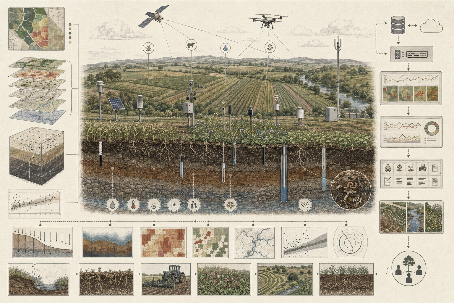
A practical soil monitoring architecture can be understood as a root-zone evidence system. The exact implementation may include soil-moisture probes, profile sensors, temperature sensors, salinity and electrical-conductivity sensors, telemetry units, field sampling, laboratory analysis, crop-stage data, soil maps, irrigation records, satellite soil-moisture products, water-balance models, dashboards, alerts, and soil information systems. The responsibilities remain consistent: observe, contextualize, transmit, validate, interpret, decide, document, and revise.
| Layer | Engineering Role | Primary Risk | Evidence Artifact |
|---|---|---|---|
| Monitoring objective layer | Defines crop, field, soil type, management zone, monitoring purpose, decision use, and evidence standard. | Measurements are collected without a clear management or reporting question. | Monitoring objective manifest, field-zone plan, decision-use statement |
| Soil-context layer | Documents texture, depth, drainage, organic matter, compaction, salinity risk, rooting zone, and management history. | Readings are interpreted without the soil properties that give them meaning. | Soil profile record, soil-type map, management history, lab results |
| Observation layer | Measures soil moisture, temperature, conductivity, salinity, nutrients, carbon, pH, structure, or related variables. | Sensors or samples observe too little of the relevant soil system. | Sensor registry, sampling protocol, lab report, observation records |
| Depth and placement layer | Links each measurement to location, depth, installation condition, crop root zone, and management zone. | Point measurements are overgeneralized to the whole field or root profile. | Depth plan, installation record, representativeness audit |
| Telemetry and storage layer | Moves readings into operational systems while preserving timestamps, units, metadata, and outages. | Data arrive without enough context to diagnose gaps, drift, or failure. | Telemetry log, missingness report, data-quality flags |
| Calibration and validation layer | Checks sensor performance, installation effects, soil-specific calibration, and agreement with reference data. | Plausible-looking readings become agronomically misleading. | Calibration record, field validation, comparison with samples or reference products |
| Integration and modeling layer | Combines point sensors, lab results, weather, crop stage, satellite products, and water-balance models. | Methods are combined without scale or uncertainty discipline. | Integration manifest, model card, scale caveat, uncertainty statement |
| Decision and governance layer | Connects soil evidence to irrigation, nutrient timing, drought interpretation, runoff risk, stewardship, and policy use. | Soil data remain visible but do not change decisions or accountability. | Decision log, alert registry, governance log, public evidence package |
This architecture makes clear that soil monitoring is not only sensing. It is the management of an evidence chain from subsurface condition to decision and accountability.
Implementation Pattern
A rigorous soil-monitoring implementation begins with the decision being supported. Irrigation scheduling, drought assessment, nutrient management, soil-health evaluation, salinity control, runoff-risk interpretation, crop forecasting, groundwater-recharge estimation, and national soil-information planning do not require identical monitoring designs. Each purpose implies different spatial density, depth distribution, sampling frequency, calibration, telemetry, validation, and reporting expectations.
| Artifact | Purpose | Suggested Format |
|---|---|---|
| Monitoring objective manifest | Defines crop, field, soil type, management zone, monitoring purpose, temporal horizon, and decision use. | YAML, Markdown, architecture decision record |
| Soil profile and field-zone registry | Documents texture, drainage, rooting depth, management zone, topography, compaction, and salinity context. | CSV, GeoJSON, SQL table |
| Sensor and sampling registry | Tracks sensor ID, depth, location, method, unit, installation date, calibration status, and ownership. | CSV, SQL table, geospatial registry |
| Installation and calibration record | Documents placement quality, soil disturbance, calibration method, maintenance, and field checks. | Markdown, CSV, maintenance log |
| Soil observation records | Stores time-stamped moisture, temperature, conductivity, salinity, or related readings with quality flags. | CSV, Parquet, SQL table, time-series database |
| Laboratory and sampling results | Stores pH, nutrients, organic carbon, texture, bulk density, and other lab-derived properties. | CSV, PDF, lab-report archive, SQL table |
| Remote and modeled soil-moisture linkage | Connects in situ observations to satellite, water-balance, or gridded soil-moisture products. | GeoTIFF, NetCDF, CSV extract, API output |
| Irrigation and management decision log | Records how soil data influenced irrigation, fertigation, nutrient timing, or field intervention. | CSV, SQL table, dashboard export |
| Public evidence package | Explains methods, scale, uncertainty, calibration, caveats, and valid-use limits for reporting. | Markdown, HTML, PDF, dashboard note |
| Governance and revision log | Tracks calibration changes, failed sensors, revised thresholds, product updates, and reporting decisions. | CSV, SQL table, changelog |
The implementation goal is to make soil-based decisions reconstructable. A user should be able to move from an irrigation recommendation, drought assessment, soil-health interpretation, or runoff-risk claim back to the sensor placement, depth, calibration, soil context, weather context, model input, uncertainty statement, and decision rule that produced it.
Research-Grade Framing: Soil Monitoring as Root-Zone Knowledge Infrastructure
A research-grade account of soil monitoring begins by treating it as root-zone knowledge infrastructure rather than as device deployment. Soil monitoring systems determine which subsurface conditions become visible, which depths are represented, how local heterogeneity is interpreted, how point observations are generalized, how satellite and model products are validated, and how soil data become agronomic or environmental claims. In that sense, soil monitoring organizes the conditions under which root-zone reality becomes knowable.
This role is epistemically demanding because soil knowledge is usually inferential and partial. A sensor records conditions at one installation point and depth. A lab sample represents a collected material under a sampling design. A satellite product estimates surface or profile moisture at larger scale. A water-balance model uses weather, land cover, soil properties, and assumptions to estimate fluxes and storage. Each method reveals part of the soil system while leaving other dimensions inferred. The monitoring system becomes trustworthy only when those methods are combined without erasing their limits.
This inferential chain is not neutral. What becomes routinely measured gains management and governance weight. Soil moisture is often highly operational because it can be sensed continuously and linked directly to irrigation timing. Soil carbon, nutrient availability, structure, compaction, microbial condition, and biological health may require slower or more complex sampling. A monitoring system that privileges only the easiest variables can become operationally useful but ecologically thin. A strong soil monitoring system preserves the distinction between immediate operational signals and broader soil stewardship evidence.
| Limited Pattern | Stronger Pattern | Why the Shift Matters |
|---|---|---|
| Install sensors | Design a depth-aware, calibrated, decision-linked root-zone evidence system | Prevents device deployment from being mistaken for monitoring quality. |
| Track soil moisture | Interpret moisture through texture, rooting depth, crop stage, weather, and available-water capacity | Prevents water-content readings from being overinterpreted without agronomic context. |
| Use point readings | Audit spatial representativeness across management zones and soil variability | Prevents local precision from becoming field-scale overconfidence. |
| Use satellite products | Link remote estimates to in situ validation, scale caveats, and local decision limits | Prevents broad-scale visibility from being mistaken for field-scale management precision. |
| Report dashboards | Preserve calibration, uncertainty, missingness, maintenance, and decision-use history | Supports accountability when data guide irrigation, drought, or stewardship claims. |
| Treat soil as a static substrate | Monitor soil as a dynamic hydrological, chemical, biological, and management-responsive system | Connects short-term agronomy with long-term stewardship. |
The central research question is not “Can this system measure soil?” but “What kind of root-zone evidence does this system produce, at what scale, with what uncertainty, and for what decision?”
Formal Model: Moisture, Profile Representation, Calibration, and Root-Zone Evidence Quality
A useful formal model separates water content, plant-available water, profile representation, spatial representativeness, calibration quality, telemetry completeness, sampling strength, remote-product agreement, and decision readiness. Let \(\theta\) represent volumetric water content, \(\theta_{\mathrm{fc}}\) field capacity, \(\theta_{\mathrm{wp}}\) wilting point, \(Z_r\) rooting depth, \(C_{\mathrm{cal}}\) calibration quality, \(R_{\mathrm{spatial}}\) spatial representativeness, \(C_{\mathrm{telemetry}}\) telemetry completeness, \(S_{\mathrm{lab}}\) sampling/laboratory strength, \(A_{\mathrm{remote}}\) remote/in situ agreement, and \(D_{\mathrm{decision}}\) decision readiness. Root-zone evidence quality depends on these dimensions together, not on one sensor value alone.
AWC = \theta_{\mathrm{fc}} – \theta_{\mathrm{wp}}
\]
Interpretation: Available water capacity is the difference between field capacity and wilting point. It helps translate water content into plant-availability context.
S_{\mathrm{root}} = \int_{0}^{Z_r} \theta(z)\,dz
\]
Interpretation: Root-zone storage integrates soil water content across rooting depth rather than treating one shallow reading as the whole profile.
D_{\mathrm{depletion}} = \frac{S_{\mathrm{field\ capacity}} – S_{\mathrm{current}}}{S_{\mathrm{field\ capacity}} – S_{\mathrm{wilting}}}
\]
Interpretation: Depletion ratio estimates how much of the available root-zone water has been used relative to the soil’s usable water range.
C_{\mathrm{telemetry}} = \frac{N_{\mathrm{received\ records}}}{N_{\mathrm{expected\ records}}}
\]
Interpretation: Telemetry completeness measures whether operational decisions are based on continuous enough data rather than hidden gaps.
E_{\mathrm{sensor}} = \left|\theta_{\mathrm{sensor}} – \theta_{\mathrm{reference}}\right|
\]
Interpretation: Sensor error compares sensor readings with reference measurements or field validation observations.
Q_{\mathrm{soil\ evidence}} =
w_1R_{\mathrm{spatial}} +
w_2R_{\mathrm{depth}} +
w_3C_{\mathrm{cal}} +
w_4C_{\mathrm{telemetry}} +
w_5S_{\mathrm{lab}} +
w_6A_{\mathrm{remote}} +
w_7U_{\mathrm{uncertainty}} +
w_8D_{\mathrm{decision}}
\]
Interpretation: Soil evidence quality depends on spatial representativeness, depth representation, calibration, telemetry completeness, lab/sampling support, remote-product agreement, uncertainty communication, and decision readiness.
This formal structure protects against a common mistake in soil monitoring: treating a single reading as if it directly represented the whole root zone, the whole field, or the whole management decision. Soil evidence becomes stronger when depth, context, calibration, representativeness, and decision use are evaluated together.
What Are Soil Monitoring Systems and Agricultural Sensing?
Soil monitoring systems are integrated systems for observing, sampling, analyzing, and interpreting soil condition across agricultural and environmental settings. They include point sensors that measure variables such as moisture, temperature, conductivity, or salinity; sampling protocols for laboratory analysis; telemetry systems that transmit readings from the field; and geospatial or model-based frameworks that connect local measurements to broader agronomic, hydrological, and environmental interpretation. Agricultural sensing refers to the applied use of these observations for farm and land-management decisions, including irrigation timing, crop support, nutrient strategy, salinity management, drought response, and soil stewardship.
Such systems may include soil moisture probes and profile sensors; temperature, salinity, and electrical-conductivity sensors; manual field sampling for nutrient, pH, carbon, texture, and bulk-density analysis; telemetry and mobile-access data platforms; satellite or modeled soil-moisture products; and decision-support tools for irrigation, crop, and land management. NASA’s SMAP mission measures and maps soil moisture and freeze-thaw state, while NASA–USDA global soil-moisture data provide surface and subsurface soil moisture, profile soil moisture, and anomaly products at global scale. These broad products are powerful because they extend soil visibility beyond field points, but their value depends on careful interpretation of scale and purpose.
The defining feature of soil monitoring systems is that they make below-ground conditions partially knowable without direct excavation of the entire field. This matters because soils mediate water availability, nutrient dynamics, root development, runoff generation, salinity movement, drought impact, and resilience under weather extremes. Larger-scale soil-moisture products support agricultural, climate, and hydrological assessment, while in situ networks remain essential for local ground truth, calibration, and management.
| Monitoring Form | Primary Question | Typical Evidence | Main Risk |
|---|---|---|---|
| Point soil sensing | What is the soil condition at this location and depth? | Moisture, temperature, conductivity, salinity, profile readings | Point accuracy is mistaken for field representativeness. |
| Profile monitoring | How does condition vary through the root zone? | Multi-depth probes, soil-water storage, depletion ratios | Shallow signals are mistaken for whole-profile condition. |
| Laboratory soil analysis | What are the chemical, physical, and longer-term soil properties? | pH, nutrients, texture, organic carbon, bulk density, salinity, soil-health measures | Slow periodic data are disconnected from time-sensitive management. |
| Remote and modeled soil moisture | How do soil-moisture conditions vary across landscapes or regions? | Satellite retrievals, gridded products, anomalies, model outputs | Broad-scale estimates are overused for field-scale decisions. |
| Irrigation decision support | When, where, and how much should irrigation be applied? | Moisture thresholds, crop stage, weather, ET, depletion, management zones | Thresholds are applied without soil texture, crop, or calibration context. |
| Soil information systems | How can soil data support policy, extension, fertilizer recommendations, and resilience planning? | National soil databases, decision-support systems, soil maps, lab/sensor networks | Data systems exist without capacity, maintenance, or local decision uptake. |
Soil monitoring is therefore more than subsurface measurement. It is a structured method for producing evidence about root-zone condition, agricultural timing, hydrological response, and soil stewardship.
Why Soil Monitoring Matters
Soil monitoring matters because soils regulate some of the most important constraints in agriculture: water availability, nutrient supply, salinity stress, temperature conditions, root development, compaction, runoff generation, and resilience under weather variability. Soil moisture in particular affects plant production potential, rainfall-runoff response, drought severity, irrigation need, and hydrological interpretation. This means soil condition is not only a farm-management variable. It is also a watershed, climate, food-system, and resilience variable.
It also matters because many soil processes are not directly visible from the surface. Crops may show stress only after moisture deficits, salinity pressure, compaction, or nutrient imbalances have already developed. Runoff risk may reflect antecedent saturation that is not obvious from rainfall totals alone. Nutrient availability may depend on moisture, temperature, chemistry, and biological processes rather than on total stock alone. Soil monitoring creates the empirical basis needed to distinguish surface appearance from root-zone condition.
Soil monitoring also matters because management increasingly requires timing rather than only diagnosis. In irrigation, the critical question is often not whether a field is dry in the abstract, but whether moisture at a particular depth and moment is sufficient for the crop and whether irrigation can be delayed, targeted, reduced, or advanced. In nutrient management, the question is not only how much nutrient is present, but when it is available, how water status affects uptake or movement, and whether management action increases loss risk. Soil monitoring is thus a temporal infrastructure for agronomy: it changes when intervention occurs, not only what is known about the soil.
| Need | Monitoring Contribution | Risk Without Monitoring |
|---|---|---|
| Irrigation management | Links soil moisture, root-zone depletion, crop stage, and timing decisions. | Water is applied too early, too late, too much, or too uniformly. |
| Drought assessment | Shows soil-water deficits that connect meteorological drought to agricultural stress. | Drought is interpreted only through rainfall or surface symptoms. |
| Runoff and recharge interpretation | Links rainfall response to antecedent moisture, water balance, and infiltration context. | Flood, runoff, or recharge response is interpreted without subsurface storage context. |
| Nutrient management | Connects nutrient availability, timing, water status, and movement risk. | Nutrient decisions are based on static stock without temporal availability context. |
| Salinity and stress management | Tracks conductivity, water movement, irrigation practices, and drainage-related stress. | Salinity risk develops gradually before crop symptoms are recognized. |
| Soil stewardship | Links short-term sensing with longer-term soil health, carbon, structure, and capacity. | Operational optimization ignores slow soil degradation. |
| Food-system resilience | Supports soil information systems, advisory services, fertilizer recommendations, and policy capacity. | Regions with weak soil data remain dependent on generalized recommendations and delayed evidence. |
Soil monitoring matters because the root zone is where water, nutrients, crops, weather, and management converge. Decisions that ignore that hidden layer often become reactive rather than adaptive.
Soil Monitoring as Root-Zone Knowledge Infrastructure
A deep understanding of soil monitoring requires treating it as root-zone knowledge infrastructure. Soil monitoring systems do not simply gather data. They organize how subsurface agricultural condition becomes knowable: which depths are measured, which properties are observed continuously, which still depend on laboratory analysis, how field heterogeneity is handled, how local observations are linked to remote products, and how measurements become management thresholds.
This role is epistemically demanding because soil knowledge is often inferential and partial. A moisture sensor records conditions at a location and depth, not across the entire rooting zone. Electrical conductivity may indicate salinity or related soil conditions, but requires contextual interpretation. Laboratory analysis can describe nutrients, pH, organic carbon, and texture, but usually lacks continuous temporal resolution. Satellite soil-moisture products can describe large-scale surface or profile conditions, yet require in situ validation and may not resolve field-scale variability in the way a grower needs. Larger-scale soil observation is therefore powerful precisely because it complements rather than replaces ground-based observation.
In this sense, soil monitoring is not just about measuring soil. It is about building a usable observational bridge between field-scale root-zone reality, larger-scale environmental models, and agronomic action. That bridge must preserve enough depth, context, and calibration that a reading can be transformed into a meaningful management judgment rather than remaining a technically correct but operationally ambiguous number.
| Monitoring Choice | What Becomes More Visible | What May Remain Less Visible |
|---|---|---|
| Single-depth moisture sensing | Local water dynamics at one depth. | Whole-profile storage, deeper root-zone stress, spatial heterogeneity. |
| Multi-depth profile sensing | Root-zone dynamics and water movement through the profile. | Chemical, biological, and structural soil condition unless separately sampled. |
| Laboratory soil testing | Nutrients, pH, carbon, texture, salinity, and longer-term properties. | High-frequency temporal dynamics between sampling events. |
| Remote soil-moisture products | Regional and global moisture patterns, anomalies, and drought context. | Fine field-scale variability and installation-specific management thresholds. |
| Irrigation dashboards | Operational timing, threshold comparison, and management response. | Calibration uncertainty, representativeness limits, slow soil-health change. |
| National soil information systems | Policy, fertilizer recommendation, capacity building, and soil-data continuity. | Local interpretive complexity unless linked to extension and field validation. |
Soil monitoring is powerful because it makes a hidden medium operationally visible. It is risky when that visibility is mistaken for completeness.
Core Soil Parameters and Measurement Targets
Soil monitoring systems typically focus on variables that matter for crop performance, hydrological behavior, environmental quality, or long-term soil condition. Among these, soil moisture is often the most operationally central because it links directly to plant water availability, irrigation timing, drought assessment, runoff generation, and recharge interpretation. But moisture is only one part of the soil system.
Common monitoring targets include soil moisture, soil temperature, electrical conductivity, salinity-related indicators, pH, nutrient condition, organic carbon, texture, bulk density, compaction, infiltration, freeze-thaw state, and broader soil-health or biological indicators where relevant. These parameters differ in how they are measured. Some can be sensed continuously. Others require sampling and laboratory analysis. Some support immediate operational decisions. Others support longer-term stewardship or policy evaluation.
No single variable is sufficient to describe soil condition as a whole. Moisture interacts with crop stage, texture, rooting depth, evapotranspiration, compaction, and irrigation scheduling. Nutrients depend on both stock and availability. Salinity stress can be influenced by irrigation practices and drainage. Organic carbon and structure evolve more slowly than daily moisture conditions. Soil monitoring is therefore a relational logic of parameter interaction, not just a list of agronomic readings.
| Parameter | Why It Matters | Common Method | Interpretive Risk |
|---|---|---|---|
| Soil moisture | Controls plant water availability, irrigation timing, runoff response, and drought stress. | Moisture probes, profile sensors, satellite/model products, water-balance models | Water content is interpreted without texture, rooting depth, or available-water capacity. |
| Soil temperature | Affects germination, root activity, microbial activity, nutrient cycling, and freeze-thaw dynamics. | Temperature probes, profile sensors, weather-linked models | Surface temperature is mistaken for root-zone thermal condition. |
| Electrical conductivity / salinity | Indicates salinity risk, dissolved ions, moisture-related conductivity, or management effects. | EC sensors, salinity probes, lab analysis, geophysical methods | Conductivity is overinterpreted without soil-water and chemical context. |
| pH and nutrients | Shape fertility, nutrient availability, crop uptake, and amendment needs. | Soil sampling and laboratory analysis | Total stock is mistaken for plant-available nutrient timing. |
| Organic carbon / organic matter | Supports structure, water retention, nutrient cycling, biological activity, and soil stewardship. | Laboratory analysis, soil-health assessment, repeated sampling | Slow change is overclaimed from short monitoring windows. |
| Bulk density / compaction | Affects rooting, infiltration, aeration, runoff, and water storage. | Core sampling, penetrometer, field assessment | Surface condition is used without profile or management-zone context. |
| Texture and structure | Determine water holding, drainage, rooting, nutrient behavior, and sensor interpretation. | Lab analysis, soil survey, field description | Moisture thresholds are transferred across soils without adjustment. |
| Freeze-thaw state | Influences hydrology, runoff, root-zone access, and seasonal land-atmosphere dynamics. | Remote sensing, soil temperature, modeled products | Large-scale products are used without local validation. |
The same measurement can mean very different things in different soil systems. A moisture reading that indicates adequate water in a fine-textured soil may imply emerging stress in a coarse soil with lower available-water capacity. A conductivity reading can suggest fertility context in one setting and salinity risk in another. Soil data acquire meaning through soil type, management history, crop demand, and hydrological setting.
Key Analytical Distinctions
Soil moisture is not the same as soil health. Moisture is often the most operationally monitored variable, but broader soil health or fertility assessment may require laboratory analysis, organic-matter interpretation, structural assessment, biological indicators, and longer-term context.
Point sensing is not the same as field representation. A sensor reports conditions at its installation depth and location, not across the entire field or landscape. Proper placement and undisturbed installation are central to whether point data can support wider inference.
Remote sensing is not the same as in situ monitoring. Satellite and modeled products provide broader spatial context, but in situ measurements remain essential for local calibration, validation, and field-level management.
Soil monitoring is not identical to crop sensing. Crop canopies may reveal stress responses, but root-zone monitoring targets subsurface conditions that often precede visible plant symptoms. Soil sensing and crop sensing are related but analytically distinct.
Availability is not the same as quantity. A nutrient stock in the soil does not automatically translate into plant-available nutrient at the moment the crop needs it. Water, temperature, chemistry, and biological processes mediate what is actually usable.
Profile condition is not the same as surface condition. Surface moisture may respond rapidly to rainfall while deeper layers change more slowly. Management errors often arise when shallow signals are mistaken for whole-profile condition.
| Distinction | Why It Matters | Design Implication |
|---|---|---|
| Moisture versus soil health | Moisture is operationally important but not a full soil-health diagnosis. | Pair moisture sensing with sampling, structure, carbon, nutrient, and stewardship indicators. |
| Point measurement versus management zone | A local reading may not represent the entire zone being managed. | Design sensor placement around soil variability and decision zones. |
| Surface condition versus root-zone condition | Shallow signals can diverge from deeper plant-available water. | Use depth profiles and crop-stage interpretation where irrigation decisions are high stakes. |
| Remote estimate versus field operation | Satellite and model products have scale and retrieval assumptions. | Use in situ validation and scale caveats before field-level recommendations. |
| Quantity versus availability | Water and nutrients become useful through soil texture, chemistry, biology, and crop demand. | Link measurements to available-water capacity, rooting depth, crop stage, and lab context. |
| Data visibility versus decision accountability | A dashboard can show readings without demonstrating better decisions. | Maintain decision logs, threshold rationales, and outcome review. |
These distinctions prevent soil monitoring from being reduced to sensor readings. The soil system is layered, contextual, and management-responsive; monitoring must preserve enough of that structure to support credible decision-making.
System Architecture: From Soil Observation to Agronomic Decision Support
Soil monitoring systems operate as layered architectures that connect below-ground observation to management action. In situ sensors, samples, and remote products capture soil condition at selected depths, locations, and scales. Measurements are time-stamped, georeferenced, and linked to soil type, depth, crop, field, and management context. Telemetry or data services move observations into operational platforms. Validation checks readings against calibration expectations, field conditions, reference observations, and neighboring signals. Interpretation compares soil information with thresholds, crop needs, irrigation timing, model expectations, drought status, or nutrient planning. Growers, operators, analysts, and institutions then use the information for irrigation, drought response, nutrient planning, runoff interpretation, and land stewardship.
| Stage | Transformation | Failure Risk |
|---|---|---|
| Soil process | Water, heat, solutes, roots, microbes, structure, and management interact below ground. | The selected variables fail to represent the soil process of concern. |
| Observation | Sensors, samples, remote products, and models capture partial soil evidence. | Measurements are too shallow, sparse, poorly placed, or weakly calibrated. |
| Metadata and context | Observations are linked to depth, soil type, crop stage, location, method, unit, and time. | Readings arrive without enough context to interpret them agronomically. |
| Telemetry and storage | Data are transmitted, stored, synchronized, and made available for operational use. | Gaps, outages, missing units, or stale data are hidden from users. |
| Validation and QA/QC | Readings are checked for plausibility, drift, calibration, installation effects, and reference agreement. | Sensor drift or installation error becomes a false management signal. |
| Interpretation | Soil readings become depletion, stress, salinity risk, nutrient timing, or runoff-risk indicators. | Thresholds are applied without soil, crop, or scale context. |
| Decision use | Soil evidence informs irrigation, nutrient planning, drought response, stewardship, or policy capacity. | Monitoring becomes informational but not accountable to outcomes. |
This architecture matters because the value of soil data depends on more than sensing alone. A moisture probe without calibration or depth context may mislead. A satellite product without local reference may be too coarse for operational use. A laboratory result without timing relative to irrigation or rainfall may be hard to apply. Soil monitoring becomes decision-relevant when observation, context, and response are linked coherently.
In Situ Sensors, Sampling, Remote Sensing, and Modeling
Modern soil monitoring uses multiple methods because no single observational mode adequately resolves the full soil system. In situ sensors provide local, often high-frequency measurements at defined depths. Best-practice guidance on soil-moisture sensors emphasizes placement in undisturbed soils and appropriate installation practice, illustrating that sensor performance is inseparable from field method. A sensor’s usefulness depends not only on its specification but on whether it is installed, calibrated, maintained, and interpreted in relation to the surrounding soil profile.
Sampling and laboratory analysis remain important for nutrients, pH, carbon, texture, bulk density, and broader soil properties that are not captured by routine field sensors. These methods provide analytical depth and interpretive breadth, even if they lack the temporal continuity of sensor data. In many systems, the strongest design is hybrid: continuous sensing for temporal dynamics, targeted sampling for chemistry and broader soil characterization, and contextual data for management interpretation.
Remote sensing and modeled products extend soil monitoring across larger spatial scales. SMAP measures and maps soil moisture and freeze-thaw state, NASA–USDA global soil-moisture products provide surface and subsurface soil-moisture information and anomalies, and USGS soil-water-balance tools estimate water-balance components and potential recharge using common gridded and tabular inputs. These methods do not replace field observations; they extend them into regional and larger-scale intelligence.
| Method Family | Strength | Limitation | Best Use |
|---|---|---|---|
| In situ soil sensors | High-frequency local measurements at known locations and depths. | Limited spatial representativeness; sensitive to placement and calibration. | Irrigation timing, profile dynamics, local validation, field operations. |
| Manual sampling and laboratory analysis | Strong chemical, physical, and soil-health characterization. | Periodic, slower, and often less temporally continuous. | Nutrients, pH, carbon, texture, bulk density, salinity, soil-health assessment. |
| Remote sensing | Broad spatial visibility and repeated regional or global observation. | Scale, retrieval, depth, vegetation, and local validation constraints. | Drought context, regional soil-moisture anomaly, large-area assessment. |
| Water-balance modeling | Connects weather, land cover, soil storage, ET, runoff, and recharge estimation. | Depends on model assumptions and input quality. | Hydrological analysis, recharge estimation, drought and water-balance interpretation. |
| Decision-support platforms | Translate soil observations into irrigation, nutrient, or stewardship guidance. | Can hide uncertainty, calibration status, or model assumptions. | Operational scheduling, advisory services, grower dashboards, policy support. |
| National soil information systems | Organize soil data for extension, fertilizer recommendations, policy, and resilience planning. | Require institutional capacity, maintenance, standards, and local uptake. | Soil governance, agrifood resilience, national planning, sustainable soil management. |
The strongest soil monitoring systems combine in situ measurement, sampling, remote sensing, modeling, and management context. The problem is not simply to measure more soil variables, but to measure and interpret them in a way that supports decisions at the right scale.
Representativeness, Depth, and Spatial Variability
One of the central intellectual challenges in soil monitoring is representativeness. Soil is highly variable across short distances because of texture, topography, drainage, organic matter, compaction, rooting patterns, salinity distribution, management history, and irrigation heterogeneity. A single sensor can be precise and still weakly representative. A single sample can be chemically valid and still fail to represent the management zone. Monitoring design must therefore ask what each measurement represents and what it does not.
Depth compounds the problem. Near-surface soil moisture can change rapidly after rainfall or irrigation, while deeper-root-zone conditions respond more slowly. Surface-focused remote sensing may not fully capture deeper plant-available water conditions without modeling or data integration. A profile-aware interpretation can reveal whether water remains accessible to roots, whether irrigation has reached the intended depth, whether deep percolation risk is rising, or whether surface wetness hides deeper depletion.
Representativeness therefore depends on network design, placement strategy, depth selection, and the scale of the management question. A point sensor may be excellent for a specific irrigation zone, less useful for whole-field generalization, and insufficient for basin-scale hydrological inference without additional context. Soil monitoring is thus always a problem of selective visibility rather than total subsurface transparency.
| Challenge | Consequence | Mitigation |
|---|---|---|
| Soil texture variability | Moisture thresholds differ across soil types and available-water capacity. | Use soil-zone mapping and texture-specific interpretation. |
| Depth mismatch | Sensor readings do not match active rooting depth or management question. | Use crop-stage-aware depth profiles. |
| Topographic variation | High and low areas differ in drainage, saturation, runoff, and stress. | Stratify placement by landscape position. |
| Irrigation heterogeneity | Application uniformity affects local readings and field interpretation. | Link sensor placement to irrigation zones and distribution uniformity. |
| Management-history variation | Tillage, compaction, amendments, and traffic create uneven soil behavior. | Maintain management history and compaction context. |
| Remote product scale mismatch | Broad soil-moisture estimates may not resolve field-level variability. | Use in situ validation and scale caveats. |
| Sampling bias | Convenient or accessible sampling locations overrepresent easy conditions. | Use sampling plans tied to soil zones, gradients, and decision needs. |
Soil monitoring design cannot be separated from agronomic purpose. The spatial density appropriate for a research field, an irrigated block, a drought-monitoring network, and a national soil information system will not be the same. Monitoring quality depends not on maximizing data indiscriminately, but on matching observational design to the scale and consequence of the decision.
Calibration, Validation, and Data Integrity
Soil monitoring depends on calibration and validation because sensor readings are shaped by installation quality, soil disturbance, depth, moisture regime, soil texture, salinity, temperature, and local soil properties. Installation guidance for soil-moisture sensors underscores that data quality in soil monitoring is produced through method as much as through device specification. A sensor may be technically capable but still produce weak evidence if it is poorly installed, weakly calibrated, or interpreted outside its valid soil context.
Validation is especially important where in situ observations are used to support larger network, satellite, or model products. Field data remain essential for evaluating wider products and for understanding where larger-scale estimates diverge from local conditions important to growers, hydrologists, or land managers. Conversely, remote and modeled products can help identify whether local measurements are behaving plausibly in relation to broader weather and hydrological patterns.
Data integrity is a chain property. It depends on whether the path from soil condition to logged number remains interpretable enough that the resulting record can support inference. Calibration is not a one-time predeployment ritual. It is part of the continuing life of the sensor, the maintenance of the monitoring network, and the evidentiary status of every value the system produces.
| Check | Purpose | Failure Signal |
|---|---|---|
| Installation-depth verification | Ensures readings correspond to intended soil layer and root-zone question. | Depth record missing or inconsistent with crop-rooting interpretation. |
| Undisturbed-placement review | Checks whether installation altered the soil contact or measurement environment. | Air gaps, disturbed soil, poor sensor-soil contact, unstable readings. |
| Soil-specific calibration | Adjusts interpretation to local texture, salinity, bulk density, and soil properties. | Generic calibration applied to high-stakes management without validation. |
| Telemetry completeness | Reveals gaps, stale data, outages, and hidden missingness. | Dashboard shows latest value without record-completeness warning. |
| Reference comparison | Compares sensors with manual samples, neighboring sensors, lab data, or reference products. | Persistent disagreement without investigation or caveat. |
| Plausibility checks | Flags impossible values, flatlines, jumps, drift, or weather-inconsistent behavior. | Sensor appears stable because it has silently failed. |
| Maintenance and revision log | Preserves context for replacement, recalibration, repair, or threshold changes. | Time series changes after maintenance without annotation. |
Without these checks, soil monitoring can become data-rich but agronomically misleading. A technically functioning system can still fail if readings are poorly positioned, weakly documented, uncalibrated, or interpreted outside the soil context that gives them meaning.
Irrigation, Nutrients, and Soil-Management Applications
One of the strongest application areas for soil monitoring is irrigation management. Digital sensor approaches can support more precise irrigation decisions by showing whether root-zone moisture is approaching a management threshold, whether irrigation has reached the intended depth, whether water remains available after rainfall, and whether irrigation can be delayed, reduced, or targeted. Soil moisture visibility helps change irrigation from schedule-based habit toward evidence-based timing.
Soil monitoring also supports nutrient management by linking root-zone water status to nutrient availability, uptake, leaching risk, and management timing. Nutrient decisions are rarely only about total stock. They are about the interaction between nutrients, water, temperature, crop stage, microbial processes, soil chemistry, and management conditions. Soil monitoring can therefore improve the timing and interpretation of nutrient application, especially when paired with laboratory testing and field history.
At larger scales, soil monitoring contributes to drought analysis, runoff forecasting, recharge estimation, agricultural assessment, and food-system resilience. Soil moisture links farm-scale sensing to regional hydrological and climate-relevant intelligence, which is why it is prominent in both agricultural management and drought-monitoring systems. The same root-zone information that supports daily irrigation can also help interpret broader water stress when aggregated, validated, and scaled appropriately.
| Application | Soil Evidence Needed | Decision Use | Key Caveat |
|---|---|---|---|
| Irrigation scheduling | Root-zone moisture, depletion, soil texture, crop stage, weather, ET. | Delay, advance, reduce, target, or verify irrigation. | Thresholds must match soil and crop context. |
| Fertigation and nutrient timing | Moisture status, nutrient test, crop demand, leaching risk, application history. | Align nutrient delivery with uptake and water movement. | Total nutrient stock is not the same as availability. |
| Drought monitoring | Surface and root-zone moisture, anomalies, crop stress, regional context. | Assess agricultural drought severity and recovery. | Large-scale products require local interpretation. |
| Runoff-risk review | Antecedent moisture, soil saturation, infiltration capacity, rainfall forecast. | Anticipate runoff, erosion, nutrient loss, or flood response. | Rainfall totals alone are insufficient. |
| Salinity management | Electrical conductivity, irrigation water, drainage, moisture movement, crop tolerance. | Adjust irrigation, leaching, drainage, and crop strategy. | Conductivity needs chemical and moisture context. |
| Soil-health stewardship | Carbon, structure, compaction, infiltration, biological indicators, moisture dynamics. | Evaluate long-term management and resilience. | Many soil-health indicators change slowly. |
| Policy and advisory systems | Soil maps, lab networks, sensor data, decision-support tools, regional calibration. | Fertilizer recommendations, extension, resilience planning, sustainable soil management. | Requires institutional capacity and data governance. |
The strongest soil-management applications use monitoring to connect short-term operational action with long-term stewardship. Soil monitoring should not only optimize the next irrigation event. It should help protect the soil system that future production depends on.
Governance, Soil Information Systems, and Capacity
Soil monitoring has a governance dimension because soil data become most powerful when organized into durable information systems rather than isolated measurements. FAO’s SoilFER work frames soil mapping and soil information as a basis for policymaking, fertilizer recommendations, national soil information systems, decision-support systems, and sustainable soil management. This matters because soil monitoring is not only a technical activity; it is a capacity-building activity.
Monitoring capacity is uneven. Not all regions have strong soil-laboratory infrastructure, sensor networks, calibration capacity, extension services, data platforms, or integrated soil information systems. Where soil condition is poorly observed, irrigation, fertility, drought response, and land stewardship must rely more heavily on generalized recommendations, delayed crop symptoms, or sparse sampling. Where soil is well observed, root-zone condition can become part of adaptive decision-making, agricultural advisory services, and public policy.
Weak soil monitoring is therefore often not just a device gap but an institutional gap. The ability to observe soils systematically shapes whose agricultural systems receive timely support, whose landscapes can be managed with better evidence, and which regions can translate subsurface knowledge into more resilient agrifood policy. Soil information systems become credible when they combine data infrastructure with local validation, analytical capacity, governance, maintenance, and extension pathways.
| Governance Responsibility | Question | Evidence |
|---|---|---|
| Calibration governance | Who defines calibration methods, maintenance intervals, and valid-use limits? | Calibration policy, maintenance log, sensor method note |
| Data-quality governance | Are missingness, drift, telemetry gaps, and field anomalies visible? | QA/QC flags, completeness report, anomaly log |
| Threshold governance | Who defines irrigation, salinity, drought, nutrient, or runoff thresholds? | Threshold registry, soil/crop rationale, revision history |
| Scale governance | Are field, watershed, regional, and national products used at appropriate scales? | Scale statement, validation record, product caveat |
| Soil-information governance | Are soil data organized for durable access, interpretation, advisory use, and policy support? | Soil information system, metadata standard, data stewardship plan |
| Capacity governance | Do users have the laboratory, extension, digital, and analytical capacity to use the system? | Training plan, lab network, extension pathway, decision-support workflow |
| Public accountability | Can soil-related claims about resilience, sustainability, drought, or productivity be evaluated? | Public evidence package, uncertainty statement, reporting methodology |
Governance is how soil monitoring remains trustworthy after sensor readings enter dashboards, irrigation schedules, fertilizer recommendations, drought assessments, sustainability claims, and national soil-information systems.
Future Directions
The future of soil monitoring lies in stronger integration across in situ sensing, laboratory analysis, remote sensing, telemetry, water-balance modeling, decision-support systems, and national soil information systems. SMAP and NASA–USDA products show how space-based and model-supported observation can extend soil visibility across large areas, while FAO’s SoilFER work demonstrates how soil mapping, digital tools, national soil information systems, and decision-support systems can strengthen soil governance and agrifood resilience.
Artificial intelligence and digital agriculture platforms will likely increase the use of sensor fusion, anomaly detection, irrigation recommendation systems, yield-risk modeling, salinity-risk mapping, and adaptive nutrient guidance. But these tools will also make evidence governance more important. If models infer soil condition from sensor streams, satellite products, weather data, and management records, the monitoring system must preserve calibration status, soil context, model version, training data, uncertainty, and valid-use limits. Otherwise automated recommendations may amplify weak placement, poor calibration, or scale mismatch.
The deeper challenge is not simply collecting more soil data. It is building monitoring systems that are representative, well-calibrated, depth-aware, uncertainty-aware, and decision-relevant. Future systems will need stronger integration between field sensing and larger-scale products, clearer handling of soil variability, and more explicit coupling among soil observation, irrigation, drought, nutrient management, runoff risk, and long-term stewardship.
Soils are rarely directly visible as systems. Their most consequential dynamics occur beneath the surface, across uneven landscapes, and on timescales that mix rapid water response with slower structural, chemical, and biological change. Where soil monitoring is strong, the root zone becomes more knowable, more manageable, and more governable. Where it is weak, agriculture and land management remain more reactive and more uncertain. In that sense, soil monitoring systems are infrastructures of subsurface visibility, agronomic accountability, and environmental stewardship.
Deployment Readiness Gate
Before a soil monitoring system is used for irrigation scheduling, drought assessment, nutrient management, salinity control, soil-health reporting, runoff-risk interpretation, food-system resilience planning, or public environmental claims, it should pass a deployment readiness gate. This gate should test whether the monitoring system is representative, calibrated, depth-aware, metadata-rich, uncertainty-aware, and fit for the decision attached to it.
| Readiness Area | Required Question | Pass Evidence |
|---|---|---|
| Purpose readiness | Does the system match the crop, soil, field, management zone, temporal horizon, and decision use? | Monitoring objective manifest, decision-use statement, management-zone plan |
| Depth readiness | Are measurements aligned with root-zone depth, soil layers, and crop stage? | Depth plan, profile record, root-zone interpretation note |
| Representativeness readiness | Do sensors and samples represent relevant soil zones, topography, irrigation zones, and variability? | Placement plan, soil-zone map, representativeness audit |
| Calibration readiness | Are sensors calibrated, installed properly, and maintained for local soil conditions? | Calibration log, installation record, maintenance schedule |
| Metadata readiness | Are location, depth, unit, method, soil type, crop, installation date, and quality flags preserved? | Sensor registry, observation schema, metadata completeness report |
| Validation readiness | Are readings checked against field samples, lab results, neighboring sensors, or reference products? | Validation report, reference comparison, QA/QC results |
| Integration readiness | Are in situ data, lab results, remote products, weather, crop stage, and models integrated responsibly? | Integration manifest, scale caveat, model card, uncertainty statement |
| Decision readiness | Are thresholds and recommendations linked to soil, crop, water, and management context? | Threshold registry, irrigation rule, nutrient timing logic, decision log |
| Governance readiness | Are stewardship, revision, data-quality, public caveats, and reporting responsibilities defined? | Governance log, public evidence package, review owner |
This readiness gate prevents soil monitoring from being treated as complete merely because sensors are deployed or satellite products are available. The stronger standard is whether the system can support a defensible decision about root-zone condition and soil stewardship.
Data and Configuration Artifacts
A reproducible soil-monitoring workflow should include explicit artifacts for objectives, soil context, sensor placement, calibration, observations, laboratory results, remote-product linkage, thresholds, decisions, uncertainty, and governance. These artifacts make soil-based decisions auditable rather than hidden inside dashboards or advisory outputs.
| Artifact | Purpose | Suggested Path |
|---|---|---|
| Monitoring objective manifest | Defines crop, field, soil type, management zone, monitoring purpose, and decision use. | config/monitoring_objective.yml |
| Soil profile registry | Documents soil texture, depth, drainage, rooting zone, organic matter, and field-zone context. | data/soil_profile_registry.csv |
| Sensor and sampling registry | Stores sensor ID, depth, location, method, unit, installation, calibration, and owner. | data/sensor_sampling_registry.csv |
| Installation and calibration log | Tracks placement quality, undisturbed installation, calibration method, maintenance, and validation. | data/calibration_maintenance_log.csv |
| Soil observation records | Stores moisture, temperature, conductivity, salinity, and related time-series records. | data/soil_observation_records.csv |
| Laboratory soil results | Stores pH, nutrients, carbon, texture, bulk density, and soil-health measurements. | data/lab_soil_results.csv |
| Remote-product linkage | Connects in situ records to satellite or modeled soil-moisture products. | data/remote_soil_moisture_linkage.csv |
| Threshold and decision registry | Documents irrigation, drought, salinity, nutrient, and runoff thresholds. | data/threshold_decision_registry.csv |
| Readiness and evidence scores | Assesses representativeness, depth coverage, calibration, telemetry, lab support, uncertainty, and decision readiness. | data/soil_monitoring_readiness_scores.csv |
| Governance log | Tracks calibration revisions, sensor failures, caveats, threshold changes, and reporting decisions. | data/soil_monitoring_governance_log.csv |
These artifacts turn soil monitoring into a reproducible root-zone evidence system rather than a loose collection of sensor readings, lab reports, and model outputs.
Mathematical Lens: Soil Water, Root-Zone Availability, Calibration, and Decision Readiness
Several simple metrics can help evaluate soil-monitoring readiness. These metrics are not substitutes for agronomic expertise, field validation, soil science, or local management judgment, but they make root-zone evidence quality more inspectable.
AWC = \theta_{\mathrm{fc}} – \theta_{\mathrm{wp}}
\]
Interpretation: Available water capacity helps translate water content into plant-availability context by comparing field capacity with wilting point.
S_{\mathrm{root}} = \int_{0}^{Z_r} \theta(z)\,dz
\]
Interpretation: Root-zone storage integrates soil water across the rooting depth rather than treating one point reading as the whole profile.
D_{\mathrm{depletion}} = \frac{S_{\mathrm{field\ capacity}} – S_{\mathrm{current}}}{S_{\mathrm{field\ capacity}} – S_{\mathrm{wilting}}}
\]
Interpretation: Depletion ratio estimates how much available root-zone water has been used relative to the soil’s usable water range.
C_{\mathrm{telemetry}} = \frac{N_{\mathrm{received\ records}}}{N_{\mathrm{expected\ records}}}
\]
Interpretation: Telemetry completeness shows whether operational decisions are based on a sufficiently continuous data stream.
E_{\mathrm{sensor}} = \left|\theta_{\mathrm{sensor}} – \theta_{\mathrm{reference}}\right|
\]
Interpretation: Sensor error compares sensor readings against reference measurements, helping identify calibration or installation problems.
Q_{\mathrm{soil\ evidence}} =
w_1R_{\mathrm{spatial}} +
w_2R_{\mathrm{depth}} +
w_3C_{\mathrm{cal}} +
w_4C_{\mathrm{telemetry}} +
w_5S_{\mathrm{lab}} +
w_6A_{\mathrm{remote}} +
w_7U_{\mathrm{uncertainty}} +
w_8D_{\mathrm{decision}}
\]
Interpretation: Soil evidence quality depends on spatial representativeness, depth representation, calibration, telemetry completeness, laboratory support, remote-product agreement, uncertainty communication, and decision readiness.
These measures evaluate soil monitoring as a root-zone evidence system. They ask whether the system is measuring enough of the right soil context to support the intended management or reporting claim.
Python Workflow: Soil Monitoring Readiness and Root-Zone Evidence Quality
A Python workflow can demonstrate how soil monitoring systems might be evaluated for spatial representativeness, depth representation, calibration quality, telemetry completeness, laboratory support, remote-product agreement, uncertainty communication, and decision readiness. The purpose is not to create a universal score, but to make evidence-quality dimensions visible.
from dataclasses import dataclass
from typing import List
import pandas as pd

@dataclass
class SoilMonitoringProgram:
    program_id: str
    crop_or_system: str
    geography: str
    spatial_representativeness: float
    depth_representation: float
    calibration_quality: float
    telemetry_completeness: float
    laboratory_support: float
    remote_product_agreement: float
    uncertainty_communication: float
    decision_readiness: float
    high_stakes_use: bool

def soil_evidence_quality(program: SoilMonitoringProgram) -> float:
    return (
        0.14 * program.spatial_representativeness +
        0.14 * program.depth_representation +
        0.14 * program.calibration_quality +
        0.12 * program.telemetry_completeness +
        0.12 * program.laboratory_support +
        0.10 * program.remote_product_agreement +
        0.10 * program.uncertainty_communication +
        0.14 * program.decision_readiness
    )

def classify_review_priority(program: SoilMonitoringProgram, score: float) -> str:
    if program.high_stakes_use and program.calibration_quality < 0.75:
        return "high_stakes_calibration_review"
    if program.spatial_representativeness < 0.70:
        return "spatial_representativeness_review"
    if program.depth_representation < 0.70:
        return "depth_representation_review"
    if program.calibration_quality < 0.75:
        return "calibration_review"
    if program.telemetry_completeness < 0.80:
        return "telemetry_completeness_review"
    if program.laboratory_support < 0.70:
        return "laboratory_support_review"
    if program.remote_product_agreement < 0.70:
        return "remote_product_validation_review"
    if program.uncertainty_communication < 0.75:
        return "uncertainty_communication_review"
    if program.decision_readiness < 0.75:
        return "decision_readiness_review"
    if score < 0.75:
        return "soil_evidence_quality_review"
    return "routine_monitoring"

programs: List[SoilMonitoringProgram] = [
    SoilMonitoringProgram(
        "irrigated-maize-profile-monitoring",
        "maize",
        "irrigated_field_block",
        0.76,
        0.86,
        0.82,
        0.92,
        0.70,
        0.72,
        0.78,
        0.86,
        True,
    ),
    SoilMonitoringProgram(
        "orchard-salinity-moisture-monitoring",
        "orchard",
        "salinity_risk_zone",
        0.72,
        0.80,
        0.76,
        0.88,
        0.78,
        0.68,
        0.76,
        0.82,
        True,
    ),
    SoilMonitoringProgram(
        "regional-drought-soil-moisture-network",
        "mixed_agriculture",
        "regional_network",
        0.68,
        0.72,
        0.78,
        0.84,
        0.66,
        0.82,
        0.78,
        0.76,
        True,
    ),
    SoilMonitoringProgram(
        "soil-health-stewardship-program",
        "soil_health",
        "conservation_fields",
        0.70,
        0.64,
        0.74,
        0.76,
        0.86,
        0.62,
        0.70,
        0.72,
        False,
    ),
]

records = []
for program in programs:
    score = soil_evidence_quality(program)
    records.append({
        "program_id": program.program_id,
        "crop_or_system": program.crop_or_system,
        "geography": program.geography,
        "spatial_representativeness": program.spatial_representativeness,
        "depth_representation": program.depth_representation,
        "calibration_quality": program.calibration_quality,
        "telemetry_completeness": program.telemetry_completeness,
        "laboratory_support": program.laboratory_support,
        "remote_product_agreement": program.remote_product_agreement,
        "uncertainty_communication": program.uncertainty_communication,
        "decision_readiness": program.decision_readiness,
        "soil_evidence_quality": round(score, 3),
        "review_priority": classify_review_priority(program, score),
    })

df = pd.DataFrame(records)
print(df.sort_values(["review_priority", "soil_evidence_quality"]))
This workflow treats soil monitoring programs as evidence systems. A program is not ready merely because it has sensors or data products. It must preserve enough evidence about spatial representation, depth, calibration, telemetry, laboratory context, remote-product validation, uncertainty, and decision use to support the intended claim.
R Workflow: Soil Condition, Irrigation Readiness, and Reporting Quality
An R workflow can support soil-monitoring governance by summarizing evidence quality across irrigation programs, drought networks, salinity-risk zones, soil-health stewardship programs, and national soil-information systems. This is useful for field audits, monitoring-program reviews, public evidence packages, and advisory-system readiness.
library(dplyr)
library(readr)

soil_programs <- tribble(
  ~program_id, ~crop_or_system, ~geography, ~spatial_representativeness, ~depth_representation, ~calibration_quality, ~telemetry_completeness, ~laboratory_support, ~remote_product_agreement, ~uncertainty_communication, ~decision_readiness, ~high_stakes_use,
  "irrigated-maize-profile-monitoring", "maize", "irrigated_field_block", 0.76, 0.86, 0.82, 0.92, 0.70, 0.72, 0.78, 0.86, TRUE,
  "orchard-salinity-moisture-monitoring", "orchard", "salinity_risk_zone", 0.72, 0.80, 0.76, 0.88, 0.78, 0.68, 0.76, 0.82, TRUE,
  "regional-drought-soil-moisture-network", "mixed_agriculture", "regional_network", 0.68, 0.72, 0.78, 0.84, 0.66, 0.82, 0.78, 0.76, TRUE,
  "soil-health-stewardship-program", "soil_health", "conservation_fields", 0.70, 0.64, 0.74, 0.76, 0.86, 0.62, 0.70, 0.72, FALSE
)

soil_summary <- soil_programs %>%
  mutate(
    soil_evidence_quality = round(
      0.14 * spatial_representativeness +
      0.14 * depth_representation +
      0.14 * calibration_quality +
      0.12 * telemetry_completeness +
      0.12 * laboratory_support +
      0.10 * remote_product_agreement +
      0.10 * uncertainty_communication +
      0.14 * decision_readiness,
      3
    ),
    review_priority = case_when(
      high_stakes_use & calibration_quality < 0.75 ~ "high_stakes_calibration_review",
      spatial_representativeness < 0.70 ~ "spatial_representativeness_review",
      depth_representation < 0.70 ~ "depth_representation_review",
      calibration_quality < 0.75 ~ "calibration_review",
      telemetry_completeness < 0.80 ~ "telemetry_completeness_review",
      laboratory_support < 0.70 ~ "laboratory_support_review",
      remote_product_agreement < 0.70 ~ "remote_product_validation_review",
      uncertainty_communication < 0.75 ~ "uncertainty_communication_review",
      decision_readiness < 0.75 ~ "decision_readiness_review",
      soil_evidence_quality < 0.75 ~ "soil_evidence_quality_review", TRUE ~ "routine_monitoring" ) ) %>%
  arrange(review_priority, soil_evidence_quality)

print(soil_summary)

write_csv(
  soil_summary,
  "outputs/soil_monitoring_readiness_summary.csv"
)
The R workflow emphasizes that soil-monitoring review should account for placement, depth, calibration, telemetry, laboratory context, remote-product validation, uncertainty, and decision readiness. These dimensions help prevent soil-monitoring programs from being judged by dashboard availability alone.
Systems Code: Field Sensors, Soil Records, Telemetry, and Governance Logs
Soil monitoring depends on full-stack environmental and agricultural systems code. The stack includes sensor registries, depth metadata, telemetry streams, field logs, calibration records, soil-observation schemas, lab-result tables, satellite-product linkages, decision-support thresholds, irrigation recommendations, QA/QC rules, dashboards, and governance logs. A serious companion repository should therefore include both analytical workflows and systems-code scaffolding.
| Language / Tool | Role in Companion Repository | Example Use |
|---|---|---|
| Python | Soil evidence-quality scoring, irrigation-readiness review, telemetry checks, and uncertainty summaries | Readiness scoring and review prioritization |
| R | Agronomic reporting, soil-monitoring summaries, and field audit tables | Monitoring-program audit outputs and public evidence summaries |
| SQL | Sensor registry, soil profiles, lab results, observation records, thresholds, and governance logs | Auditable soil-monitoring database schema |
| GeoJSON | Field zones, sensor locations, soil sampling points, and management-area boundaries | Spatial registry for soil monitoring sites |
| TypeScript | Dashboard and platform data models | Soil-profile cards, sensor-status panels, irrigation-readiness displays |
| Go | Lightweight soil-monitoring status endpoint | Expose telemetry, calibration, and readiness status |
| Rust | Safe validation CLI for soil-observation records and metadata | Validate required fields, units, depths, calibration status, and quality flags |
| C / C++ | Low-level embedded sensor-record and telemetry-buffer examples | Demonstrate field-device records and delayed telemetry concepts |
| Shell scripts | Reproducible directory, validation, and export workflows | One-command scaffold validation and output generation |
This breadth is appropriate because soil monitoring is not only agronomic fieldwork. It is evidence infrastructure spanning sensing, sampling, telemetry, calibration, decision support, soil information systems, and governance.
GitHub Repository
A companion repository for this article should translate the soil-monitoring framework into reproducible technical scaffolding. The repository should include monitoring objective manifests, soil profile registries, sensor and sampling registries, calibration logs, soil observation records, laboratory results, remote-product linkage files, threshold and decision registries, readiness scoring workflows, SQL schemas, dashboard data types, and governance logs.
Testing and Validation
Testing soil monitoring systems requires more than confirming that sensors produce readings. It requires validating installation, depth, calibration, metadata completeness, telemetry continuity, spatial representativeness, laboratory integration, remote-product agreement, uncertainty communication, and decision-use logic. A soil-monitoring program can appear sophisticated while producing weak evidence if any part of the chain is undocumented or untested.
| Test Type | Purpose | Example Test |
|---|---|---|
| Installation test | Ensure sensors are installed at the intended depth with acceptable soil contact and minimal disturbance. | Review installation record, depth, photographs, and field notes. |
| Calibration test | Ensure sensor interpretation is valid for local soil conditions. | Compare readings with reference samples or local calibration curves. |
| Metadata test | Ensure readings include location, depth, unit, sensor ID, soil type, crop, and quality status. | Validate observation schema and sensor registry completeness. |
| Telemetry test | Ensure data arrive with sufficient continuity for operational decisions. | Calculate expected versus received records and stale-data frequency. |
| Representativeness test | Ensure sensor and sampling locations represent relevant soil and management zones. | Compare placement against soil map, topography, irrigation zones, and management history. |
| Depth-profile test | Ensure monitoring captures the active root zone rather than only surface conditions. | Compare sensor depths with crop rooting depth and irrigation objectives. |
| Lab-integration test | Ensure sensor readings are interpreted with soil chemistry, texture, carbon, pH, or salinity context where needed. | Review lab-result linkage to sensor sites and management zones. |
| Remote-product validation test | Ensure satellite or model products are compared with in situ observations before local use. | Compare gridded estimates with local sensors and report scale caveats. |
| Decision-logic test | Ensure thresholds and recommendations are matched to soil, crop, water, and management context. | Audit irrigation or nutrient recommendations against monitoring evidence. |
| Public-evidence test | Ensure soil-related claims expose calibration, uncertainty, scale, and valid-use limits. | Review public evidence package and reporting caveats. |
Validation should test the soil monitoring system as a root-zone evidence chain. The decisive question is not only whether measurements exist, but whether they can support the decision or claim being made.
Operational Signals and Soil-Monitoring Observability
Soil monitoring systems must observe themselves. A system that monitors soil but cannot report sensor health, depth records, calibration status, telemetry completeness, missingness, maintenance events, lab-result linkage, remote-product agreement, threshold revisions, and decision outcomes is operationally fragile. Monitoring-system observability should track both technical workflow health and root-zone evidence health.
| Signal | Why It Matters | Failure Indicator |
|---|---|---|
| Sensor health | Determines whether readings are current, plausible, and technically valid. | Flatline, impossible values, drift, stale data, battery or communication failure. |
| Depth metadata | Determines whether readings can be interpreted as surface, profile, or root-zone evidence. | Unknown depth, inconsistent depth labels, or missing crop-rooting context. |
| Calibration status | Determines whether values are valid for local soil and method conditions. | Generic calibration used without validation or maintenance record. |
| Telemetry completeness | Determines whether operational decisions are based on continuous enough records. | Hidden gaps, stale readings, missing intervals, unflagged outages. |
| Representativeness status | Determines whether sensors and samples represent the decision zone. | Sensor locations do not match soil variability, topography, or irrigation zones. |
| Lab linkage | Determines whether sensor readings are interpreted with soil chemistry and physical context. | Moisture thresholds or salinity interpretations lack texture, pH, nutrient, or lab context. |
| Remote-product agreement | Determines whether satellite or model estimates align with field observations. | Persistent disagreement without scale caveat or validation review. |
| Threshold revision history | Determines whether decision logic changed over time. | Irrigation or salinity thresholds updated without documentation. |
| Decision outcome review | Determines whether monitoring improved irrigation, nutrient, drought, or stewardship decisions. | Dashboard exists but no decision or outcome log is maintained. |
| Public evidence readiness | Determines whether soil-related claims can be interpreted and contested. | No calibration caveat, no uncertainty statement, no scale statement, no governance owner. |
Operational observability protects soil monitoring from silent evidence degradation. It helps ensure that the appearance of digital agricultural precision does not outlast the quality and accountability of the monitoring system beneath it.
Engineer and Researcher Checklist
- Define the crop, field, soil type, management zone, temporal horizon, monitoring objective, and decision use before deploying sensors.
- Distinguish soil moisture, soil health, nutrient availability, salinity risk, profile condition, and crop stress rather than treating them as interchangeable.
- Document sensor location, depth, method, unit, installation date, soil type, crop stage, calibration status, and data-quality flags.
- Use soil-zone mapping and representativeness audits to avoid overgeneralizing point measurements.
- Use depth-aware interpretation when irrigation, drought, or root-zone stress decisions are high stakes.
- Pair continuous sensing with laboratory analysis where nutrients, pH, carbon, texture, salinity, or broader soil-health claims are involved.
- Validate sensors against field samples, neighboring sensors, lab data, or reference observations where possible.
- Use satellite and modeled soil-moisture products with explicit scale caveats and in situ comparison.
- Expose telemetry gaps, stale data, sensor drift, maintenance changes, and calibration revisions in operational systems.
- Maintain threshold registries for irrigation, salinity, drought, nutrient, and runoff decisions.
- Provide public evidence packages that explain methods, depth, calibration, uncertainty, representativeness, and valid-use limits.
- Ensure soil data influence decisions and stewardship review rather than merely populating dashboards.
Where This Fits in the Series
This article connects Environmental Monitoring Systems to agricultural sensing, water monitoring, remote sensing, climate monitoring, environmental sensor networks, embedded field devices, data platforms, risk and resilience, and sustainable development. It sits at the root-zone layer of the series: the point where subsurface field observations become evidence about irrigation, drought, nutrient availability, runoff behavior, and soil stewardship.
Within the broader series, this article provides the soil-monitoring framework that supports water quality monitoring systems, river and watershed monitoring networks, smart water systems and environmental sensing, climate monitoring systems and environmental observation, remote sensing systems in environmental monitoring, environmental sensor networks, embedded monitoring devices for field observation, and environmental data platforms and decision support systems. Its role is to show that soil intelligence does not emerge from sensors alone. It emerges from the relationship among placement, depth, calibration, sampling, remote products, models, uncertainty, management context, and governance.
Related articles
- Environmental Monitoring Systems
- Water Quality Monitoring Systems
- River and Watershed Monitoring Networks
- Smart Water Systems and Environmental Sensing
- Climate Monitoring Systems and Environmental Observation
- Environmental Sensor Networks
- Embedded Monitoring Devices for Field Observation
- Environmental Data Platforms and Decision Support Systems
- Remote Sensing Systems in Environmental Monitoring
- Monitoring Environmental Risk and Resilience
Further reading
- NASA Jet Propulsion Laboratory (2026) SMAP Mission. Available at: https://smap.jpl.nasa.gov/
- NASA Jet Propulsion Laboratory (2026) Soil Moisture Active Passive (SMAP). Available at: https://www.jpl.nasa.gov/missions/soil-moisture-active-passive-smap/
- NASA Earthdata (2026) Soil Moisture / Water Content. Available at: https://www.earthdata.nasa.gov/topics/land-surface/soil-moisture-water-content
- NASA Goddard Space Flight Center (2026) NASA–USDA Global Soil Moisture Data. Available at: https://earth.gsfc.nasa.gov/hydro/data/nasa-usda-global-soil-moisture-data
- National Snow and Ice Data Center (2026) Soil Moisture Active Passive Data. Available at: https://nsidc.org/data/smap/data
- U.S. Geological Survey (2018) Water Balance and Soil Moisture. Available at: https://www.usgs.gov/centers/eros/science/water-balance-and-soil-moisture
- U.S. Geological Survey (2016) Soil-Water-Balance (SWB) for estimating groundwater recharge. Available at: https://www.usgs.gov/software/soil-water-balance-swb-estimating-groundwater-recharge
- U.S. Department of Agriculture, Agricultural Research Service (2022) In situ soil moisture sensors in undisturbed soils. Available at: https://www.ars.usda.gov/research/publications/publication/?seqNo115=395752
- U.S. Department of Agriculture, Agricultural Research Service (2022) USDA scientists collaborate with partners to address soil moisture challenges on farms. Available at: https://www.ars.usda.gov/news-events/news/research-news/2022/usda-scientists-collaborate-with-partners-to-address-soil-moisture-challenges-on-farms/
- Food and Agriculture Organization of the United Nations (2026) SoilFER: Soil mapping for resilient agrifood systems. Available at: https://www.fao.org/global-soil-partnership/soilfer/en/
- Food and Agriculture Organization of the United Nations (2025) FAO advances implementation of SoilFER Programme to empower countries with resilient and informed soil decisions. Available at: https://www.fao.org/global-soil-partnership/resources/highlights/detail/en/c/1750023/
References
- Food and Agriculture Organization of the United Nations (2025) FAO advances implementation of SoilFER Programme to empower countries with resilient and informed soil decisions. Available at: https://www.fao.org/global-soil-partnership/resources/highlights/detail/en/c/1750023/ (Accessed: 14 May 2026).
- Food and Agriculture Organization of the United Nations (2026) SoilFER: Soil mapping for resilient agrifood systems. Available at: https://www.fao.org/global-soil-partnership/soilfer/en/ (Accessed: 14 May 2026).
- NASA Earthdata (2026) Soil Moisture / Water Content. Available at: https://www.earthdata.nasa.gov/topics/land-surface/soil-moisture-water-content (Accessed: 14 May 2026).
- NASA Goddard Space Flight Center (2026) NASA–USDA Global Soil Moisture Data. Available at: https://earth.gsfc.nasa.gov/hydro/data/nasa-usda-global-soil-moisture-data (Accessed: 14 May 2026).
- NASA Jet Propulsion Laboratory (2026) SMAP Mission. Available at: https://smap.jpl.nasa.gov/ (Accessed: 14 May 2026).
- NASA Jet Propulsion Laboratory (2026) Soil Moisture Active Passive (SMAP). Available at: https://www.jpl.nasa.gov/missions/soil-moisture-active-passive-smap/ (Accessed: 14 May 2026).
- National Snow and Ice Data Center (2026) Soil Moisture Active Passive Data. Available at: https://nsidc.org/data/smap/data (Accessed: 14 May 2026).
- U.S. Department of Agriculture, Agricultural Research Service (2022) In situ soil moisture sensors in undisturbed soils. Available at: https://www.ars.usda.gov/research/publications/publication/?seqNo115=395752 (Accessed: 14 May 2026).
- U.S. Department of Agriculture, Agricultural Research Service (2022) USDA scientists collaborate with partners to address soil moisture challenges on farms. Available at: https://www.ars.usda.gov/news-events/news/research-news/2022/usda-scientists-collaborate-with-partners-to-address-soil-moisture-challenges-on-farms/ (Accessed: 14 May 2026).
- U.S. Geological Survey (2016) Soil-Water-Balance (SWB) for estimating groundwater recharge. Available at: https://www.usgs.gov/software/soil-water-balance-swb-estimating-groundwater-recharge (Accessed: 14 May 2026).
- U.S. Geological Survey (2018) Water Balance and Soil Moisture. Available at: https://www.usgs.gov/centers/eros/science/water-balance-and-soil-moisture (Accessed: 14 May 2026).