
Last Updated July 13, 2026
Precision farming transforms agriculture by turning fields into monitored, data-rich environmental systems. Instead of relying only on intuition, fixed schedules, or broad field averages, precision agriculture integrates IoT sensors, drones, remote sensing, geospatial analytics, machine learning, and decision-support tools to observe soil, water, crops, nutrients, pests, and field variability with far greater spatial and temporal resolution.
Agriculture has always depended on observation. Farmers read soil texture, rainfall, crop color, plant stress, pest pressure, and seasonal rhythms through experience. Precision farming does not eliminate that knowledge. It changes the observational architecture around it. Fields that were once managed as broad units can now be understood as dynamic landscapes with zones, gradients, thresholds, microclimates, moisture patterns, nutrient variation, canopy differences, and site-specific risks.
This matters because agriculture sits at the intersection of food security, land use, water stress, climate change, rural livelihoods, energy systems, fertilizer markets, biodiversity, and public policy. Precision farming is therefore not merely a farm-technology upgrade. It is part of a broader shift toward digital agriculture: the integration of data, connectivity, sensing, automation, analytics, and governance into the systems that produce food.
Main Library
Publications
Article Map
Environmental Monitoring
Related Topic
Data Systems
Related Topic
Embedded & Edge Systems
Related Topic
Sustainable Development
The central question is not whether sensors and drones can generate agricultural data. They can. The deeper question is whether these systems improve agricultural resilience, reduce environmental harm, support farmer judgment, strengthen accountability, and remain accessible across different scales of farming. A precision system that improves input efficiency for large farms while deepening platform dependency, data asymmetry, or exclusion for small producers is not automatically sustainable. A drone map that detects crop stress but lacks agronomic interpretation can produce information without wisdom.
This article examines precision farming as an environmental monitoring system. It argues that the value of IoT sensors, drones, remote sensing, and geospatial analytics depends on how well they are integrated into human judgment, farm governance, water stewardship, soil health, data rights, interoperability, and long-term food-system resilience.
What Precision Farming Changes in Agriculture
For much of modern agricultural history, farm management decisions relied on rules of thumb, experience, regional averages, and fixed schedules. Irrigation might be applied according to calendar timing. Fertilizer might be spread uniformly across a field. Pesticides might be applied when visible damage appeared. These approaches could work reasonably well when climate patterns were more predictable, input costs were lower, fields were less instrumented, and environmental externalities were less visible in policy and market systems.
Precision farming changes that logic. It treats farmland not as a uniform production surface but as a heterogeneous and dynamic system. Soil properties vary meter by meter. Moisture changes across topography, texture, compaction, drainage, and microclimate. Pest pressure spreads unevenly. Nutrient availability differs by soil chemistry, organic matter, previous management, erosion, and biological activity. Crop stress may appear in one zone long before it is visible across the entire field.
Once these variations can be measured, farm management changes. The question is no longer simply, “Does this field need water?” It becomes, “Which zones of this field are experiencing measurable soil moisture stress, and how much water is needed to bring those zones back within an agronomically useful range?” The same shift applies to fertilizer, pest management, seeding density, harvest timing, and soil-health interventions.
Precision farming therefore changes agriculture in three ways:
- It increases spatial resolution. Field management can shift from whole-field averages to management zones, grid cells, rows, or even plant-level observations.
- It increases temporal resolution. Sensors and imaging systems can monitor change over hours, days, weeks, and seasons rather than relying only on periodic field walks or manual sampling.
- It changes the decision architecture. Data streams, analytics systems, equipment controllers, agronomic models, and platform interfaces become part of the farm-management process.
This does not make traditional knowledge obsolete. It gives farmers and agronomists new instruments for seeing field variation. The strongest precision farming systems combine local expertise with measured evidence. They do not replace farmer judgment; they make that judgment more informed.
How Precision Farming Turns Fields into Data Systems
The most important transformation associated with precision farming is not simply better hardware. It is the conversion of agricultural landscapes into data-generating environments. A field becomes a monitored system when soil sensors, weather stations, irrigation controllers, GPS-guided equipment, drones, satellite imagery, yield monitors, and farm-management platforms produce structured observations over time.
This shift has major implications. A field is no longer known only through visual inspection, memory, and seasonal experience. It is also represented through maps, time series, spectral indices, moisture curves, yield layers, prescription files, machine logs, and decision-support dashboards. These data do not replace the field. They create a second informational layer through which the field can be interpreted, governed, financed, insured, and regulated.
That second layer can be powerful. It can reveal patterns that are hard to see from the ground: persistent low-yield zones, irrigation inefficiencies, nutrient leaching risk, disease spread, crop stress before visual symptoms appear, soil compaction patterns, and the relationship between management actions and yield outcomes. It can also support more targeted interventions, allowing farmers to apply inputs where needed and avoid waste where they are not.
But the data layer also introduces new questions. Who owns field data? Who controls the platform? Can the farmer export records into interoperable systems? Are recommendations explainable? Is the model calibrated to local conditions? Can data be used by insurers, lenders, input suppliers, equipment vendors, or governments in ways that shift power away from producers? Does the system support decision-making, or does it create dependency on proprietary analytics?
Precision farming turns fields into data systems, but data systems are never neutral. They organize attention, influence decisions, and create new forms of authority. The challenge is to build agricultural data systems that support ecological performance and farmer agency rather than reducing farms to extractive data sources.
The Precision Farming Monitoring Stack
A precision farming system can be understood as a monitoring stack. Each layer converts some part of agricultural reality into information, and each layer introduces its own strengths, uncertainties, and governance needs.
| Layer | Examples | What it measures | Key governance concern |
|---|---|---|---|
| Field sensing | Soil moisture sensors, salinity probes, temperature sensors, nutrient sensors | Local environmental conditions within the field | Calibration, maintenance, placement, and data ownership |
| Weather and microclimate | Farm weather stations, humidity sensors, wind sensors, evapotranspiration models | Atmospheric conditions affecting irrigation, pests, disease, and crop stress | Data quality, local representativeness, and decision thresholds |
| Remote sensing | Satellites, drones, multispectral imagery, thermal imagery | Canopy condition, vegetation indices, water stress, crop vigor, land-cover patterns | Interpretation, validation, privacy, and spatial resolution limits |
| Machine data | Yield monitors, GPS-guided tractors, variable-rate applicators, irrigation controllers | Management actions, yield outcomes, input application, machine performance | Interoperability, vendor lock-in, and auditability |
| Analytics layer | Farm-management platforms, machine learning, prescription maps, dashboards | Recommendations, forecasts, anomaly detection, risk scores | Explainability, bias, uncertainty, and farmer oversight |
| Governance layer | Data agreements, open standards, policy rules, farmer cooperatives, public programs | Authority over data, decisions, access, and accountability | Equity, transparency, and protection from extractive platform dependency |
The monitoring stack matters because precision farming is not one technology. It is a system of systems. A drone image is useful only if it is interpreted correctly. A soil sensor is useful only if it is placed, calibrated, and maintained properly. A variable-rate prescription is useful only if it reflects crop needs, equipment capability, weather conditions, and economic constraints. A digital platform is useful only if it supports farmer decision-making rather than obscuring it.
Precision farming should therefore be evaluated not by the number of devices deployed, but by the quality of the monitoring architecture and the decisions it supports.
How IoT Sensors Enable Precision Farming
IoT technologies are one of the core foundations of precision farming. Networks of connected sensors can continuously measure soil moisture, soil temperature, salinity, nutrient indicators, air temperature, humidity, rainfall, wind, leaf wetness, irrigation flow, water pressure, equipment status, and microclimate conditions. These measurements convert agricultural variability into time-series data that can inform management.
At the field level, IoT sensors allow farmers to:
- collect continuous environmental measurements instead of occasional manual readings;
- detect hidden processes such as slow moisture depletion, soil salinity accumulation, or irrigation nonuniformity;
- identify stress conditions before they become visible in crop canopies;
- support irrigation scheduling based on measured soil and weather conditions;
- compare management zones across seasons;
- document environmental conditions for insurance, compliance, or stewardship programs.
Sensor placement is critical. A sensor network that samples only convenient locations may misrepresent field conditions. Soil texture, slope, drainage, crop type, irrigation layout, and historical yield maps should inform where sensors are placed. One sensor in a field does not make the field fully visible. It creates one measurement point. A good monitoring design asks where information is needed, what uncertainty remains, and how decisions will change based on the data.
Sensor maintenance is equally important. Soil probes drift. Batteries fail. Wireless signals degrade. Sensors can be damaged by equipment, animals, weather, or soil movement. Calibration matters. Data gaps matter. Precision farming systems should include diagnostics, maintenance schedules, metadata, and quality checks. Without them, sensor data can create false precision: numbers that appear authoritative but do not accurately represent field conditions.
IoT systems also raise governance questions. Data collected from fields can reveal productivity, management practices, risk profiles, input use, irrigation behavior, soil conditions, and financial value. If platforms aggregate these data across farms, they may gain market power over producers. Precision farming should therefore include data stewardship from the beginning, not as an afterthought.
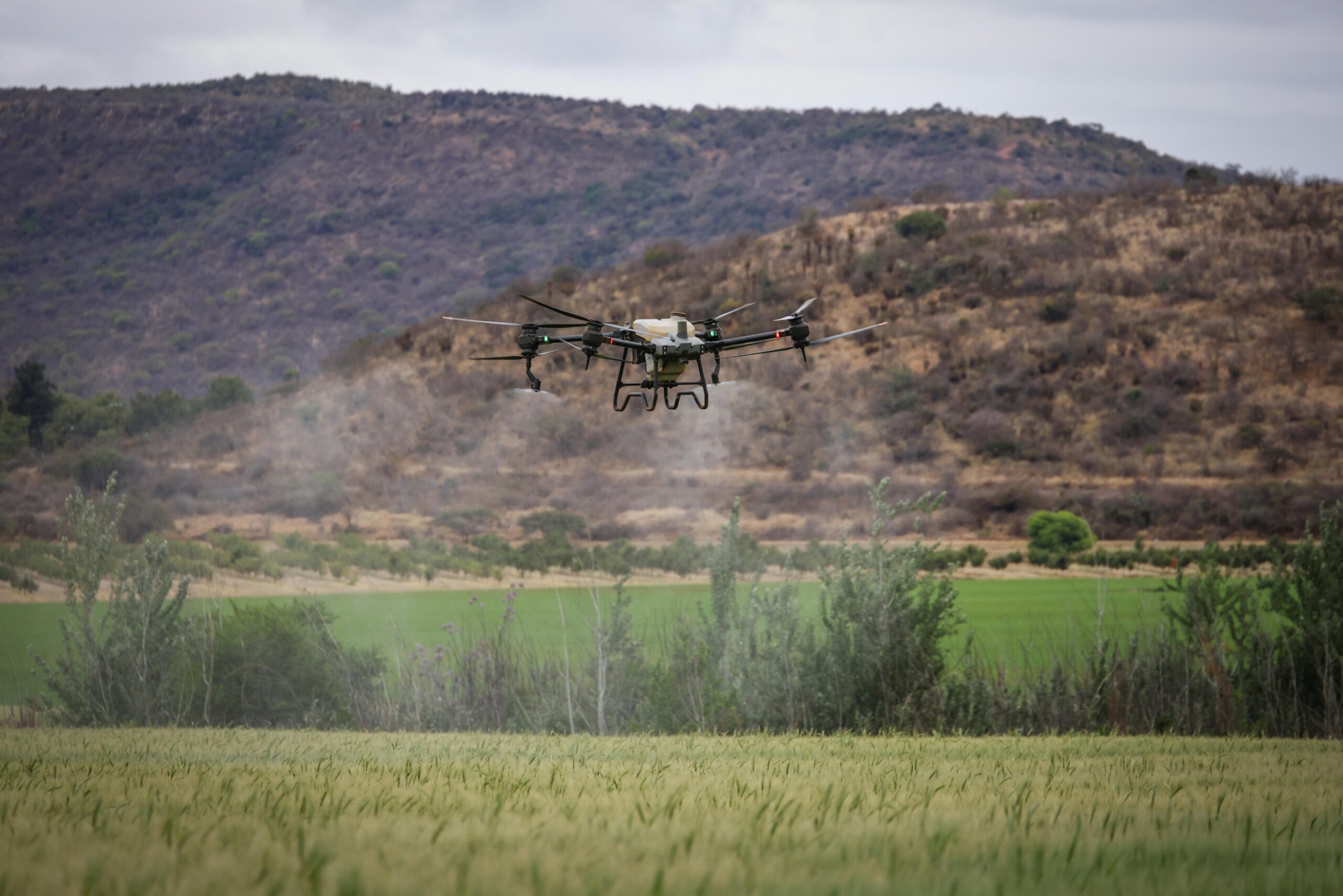
How Agricultural Drones Support Precision Farming
Agricultural drones extend precision farming into the spatial dimension. Equipped with RGB, multispectral, hyperspectral, or thermal cameras, drones can rapidly survey fields and detect patterns that may be difficult to observe from ground level. They can help identify crop stress, uneven emergence, irrigation problems, pest damage, disease symptoms, lodging, weed pressure, nutrient deficiency, drainage patterns, and variability in plant vigor.
Drone systems are especially useful because they can provide high-resolution imagery on demand. Satellites offer broad coverage, but cloud cover, revisit intervals, and spatial resolution can limit usefulness for specific management decisions. Drones can be deployed when a farmer or agronomist needs a closer look at a particular field, zone, or event.
Common drone applications include:
- RGB imaging for visual inspection, stand counts, weed mapping, and field scouting;
- multispectral imaging for vegetation indices, crop vigor, nutrient stress, and canopy differences;
- thermal imaging for irrigation stress, canopy temperature, and water-use analysis;
- topographic mapping for drainage, erosion, and field-shape analysis;
- damage assessment after storms, floods, droughts, pests, or disease events.
In a precision farming workflow, drones can function as part of a sensing–decision–action loop. Aerial imagery identifies a stress zone. The imagery is compared with soil sensor data, weather records, crop stage, historical yield maps, and field observations. Agronomic interpretation determines whether the pattern reflects moisture stress, nutrient deficiency, pest pressure, compaction, disease, or another cause. The farmer then decides whether to irrigate, scout, sample, spray, adjust fertility, or monitor further.
The key phrase is agronomic interpretation. Drone imagery does not explain itself. A low vegetation index may indicate drought stress, nutrient deficiency, disease, soil variation, weed competition, herbicide injury, or simply a different crop stage. Precision farming systems should avoid treating imagery as automatic truth. Drones are powerful observation tools, but their outputs must be validated and interpreted within local crop knowledge.
Remote Sensing, Satellites, and Geospatial Field Intelligence
Remote sensing broadens precision farming beyond individual field visits. Satellite imagery, aerial imagery, and geospatial analytics allow farmers, agronomists, researchers, insurers, lenders, and policymakers to observe agricultural landscapes across wider areas. These systems can monitor crop growth, drought stress, irrigation patterns, land-cover change, vegetation health, soil exposure, flood damage, and seasonal variability.
Satellite imagery is especially valuable for repeated observation. It allows agricultural systems to be monitored over time, across fields, watersheds, regions, and countries. This is important for food security, drought monitoring, crop forecasting, insurance assessment, water planning, and climate adaptation. Remote sensing helps connect farm-level management to landscape-level environmental conditions.
Geospatial field intelligence often combines several datasets:
- satellite vegetation indices;
- drone imagery;
- soil maps;
- yield maps;
- topography;
- weather data;
- irrigation infrastructure;
- field boundaries;
- crop history;
- management zones.
Once these layers are combined, farmers can identify zones that behave differently over time. Some areas may consistently underperform because of compaction, drainage, salinity, slope, soil texture, or nutrient limitations. Other zones may respond strongly to targeted management. Precision farming uses spatial evidence to move from uniform treatment toward site-specific management.
However, remote sensing has limits. Spectral signals are indirect. They measure reflected energy, canopy temperature, or surface patterns, not the full biological complexity of soil, roots, pests, disease, or management history. Cloud cover, shadows, sensor calibration, atmospheric correction, mixed pixels, and crop-stage differences can all affect interpretation. Like all monitoring systems, remote sensing requires validation.
The most reliable precision farming systems combine remote sensing with field knowledge. Satellite data can show where to look. Drones can provide finer detail. Sensors can provide continuous local measurements. Field scouting can identify causes. Agronomic knowledge can convert signals into decisions.
Sensing–Decision–Action Feedback Loops
Precision farming is best understood as a feedback loop. The system senses field conditions, interprets data, recommends or supports action, applies interventions, and then measures the result. This loop is what distinguishes precision farming from passive monitoring.
- Sensing: IoT sensors, drones, satellites, weather stations, yield monitors, and field observations collect data.
- Integration: data streams are combined with field boundaries, crop stage, historical records, soil maps, and management zones.
- Interpretation: agronomic analysis identifies likely causes of observed patterns.
- Decision: the farmer or advisor selects an intervention based on evidence, economics, risk, and goals.
- Action: irrigation, fertilizer, pesticide, seeding, cultivation, or scouting is applied in a targeted way.
- Evaluation: the system observes whether the intervention produced the expected result.
A strong feedback loop reduces waste because it avoids treating all field zones the same. It also supports learning. Over time, farmers can compare intervention outcomes, refine management zones, adjust thresholds, improve input timing, and identify persistent constraints. Precision farming becomes not only a technology system but a learning system.
But feedback loops can fail. Data may be inaccurate. Models may be poorly calibrated. Recommendations may not account for local economics. Equipment may apply prescriptions incorrectly. Weather may change suddenly. A platform may optimize for yield without accounting for soil health or water limits. A farmer may receive too many alerts without clear priorities. Automation can produce complexity rather than clarity.
The strongest systems are designed for human-in-the-loop decision-making. They support interpretation, allow override, document uncertainty, and preserve local expertise. Precision farming should make decisions more informed, not more opaque.
A Mathematical Lens: Variable-Rate Management and Field Variability
Precision farming can be understood through the relationship between field variability and management response. A simple representation of crop response in a field zone \(i\) is:
Y_i = f(S_i, W_i, N_i, P_i, M_i, C_i)
\]
Interpretation: Yield \(Y_i\) in zone \(i\) depends on soil conditions \(S_i\), water availability \(W_i\), nutrient status \(N_i\), pest and disease pressure \(P_i\), management actions \(M_i\), and climate conditions \(C_i\). Precision farming tries to observe these variables more clearly so management can respond to local conditions rather than field averages.
A conventional uniform input strategy applies the same rate across the field:
I_i = I_0
\]
Interpretation: Under uniform management, every zone \(i\) receives the same input rate \(I_0\), even though soil, water, nutrient demand, and crop stress may vary across the field.
Variable-rate management changes this by assigning inputs according to local need:
I_i = g(\hat{W}_i, \hat{N}_i, \hat{Y}_i, R_i)
\]
Interpretation: Input rate \(I_i\) is determined by estimated water stress \(\hat{W}_i\), nutrient status \(\hat{N}_i\), expected yield potential \(\hat{Y}_i\), and risk or constraint factors \(R_i\). The function \(g\) represents the management rule or decision model.
The goal is not simply to minimize input use. The goal is to improve the relationship between input, output, cost, risk, and environmental impact. A simplified efficiency measure might be:
E = \frac{Y}{I}
\]
Interpretation: Input efficiency \(E\) can be represented as output \(Y\) per unit of input \(I\). Precision farming can improve efficiency when it reduces unnecessary input use while maintaining or improving yield, quality, or resilience.
Environmental loss can also be represented conceptually:
L_i = \max(0, I_i – U_i)
\]
Interpretation: Potential loss \(L_i\) in zone \(i\) can be represented as the portion of input \(I_i\) that exceeds crop or soil uptake capacity \(U_i\). Over-application of water, nitrogen, or chemicals can increase runoff, leaching, emissions, cost, or ecological harm.
These equations are simplified, but they clarify the logic. Precision farming is valuable when measurement improves the match between local conditions and management action. It is not inherently sustainable. It becomes sustainable when the decision function is designed to protect soil, water, profitability, ecological integrity, and long-term resilience.
Water, Nutrients, Soil Health, and Input Efficiency
Precision farming is often justified through input efficiency. Water, fertilizer, and pesticides are expensive. They also have environmental consequences when misapplied. Over-irrigation can waste water, increase pumping costs, contribute to salinity, and reduce soil aeration. Excess nitrogen can leach into groundwater, run off into waterways, or contribute to nitrous oxide emissions. Pesticides applied without careful targeting can increase cost, harm beneficial organisms, and accelerate resistance.
Precision systems can help by making field conditions more visible. Soil moisture sensors can improve irrigation scheduling. Thermal imagery can reveal water stress. Variable-rate fertilizer systems can adjust nutrient application by zone. Drone imagery can help identify pest or disease hotspots. Yield maps can identify areas where high input rates do not produce proportional returns. Soil sampling and electrical conductivity mapping can reveal management zones.
The sustainability potential is significant, but it depends on implementation. A farmer could use precision systems to reduce inputs where they are unnecessary. Another could use the same systems to intensify production in ways that increase total environmental pressure. Technology does not determine the outcome by itself. Incentives, regulations, market conditions, agronomic goals, farmer values, and policy frameworks all matter.
Soil health is especially important. Precision farming should not be reduced to input optimization alone. Soil is a living system shaped by organic matter, structure, microbial activity, compaction, erosion, infiltration, nutrient cycling, and biological resilience. Sensors and data platforms can help monitor soil-related indicators, but soil stewardship requires long-term management choices: cover crops, reduced disturbance, crop rotation, organic amendments, erosion control, and water-sensitive practices.
A precision system that maximizes short-term yield while degrading soil is not sustainable. A stronger approach uses measurement to support regenerative and resilience-oriented management. The goal is not only to produce more with less. It is to maintain the ecological capacity of the field over time.
AI, Machine Learning, and Agronomic Decision Support
Machine learning can help precision farming systems interpret complex data. Models can classify crop stress, detect weeds, estimate yield, forecast disease risk, identify irrigation anomalies, predict equipment failure, segment management zones, and recommend variable-rate actions. AI systems are especially useful when data streams are too large or complex for manual analysis alone.
Examples include:
- computer vision models that identify crop rows, weeds, disease symptoms, or damaged plants;
- time-series models that detect soil moisture trends or irrigation anomalies;
- yield prediction models that combine weather, soil, crop, and management data;
- classification models that identify crop stress from multispectral imagery;
- decision-support systems that recommend irrigation or nutrient timing;
- predictive maintenance systems for pumps, tractors, sprayers, drones, and irrigation equipment.
But agricultural AI must be treated carefully. Models trained in one region, crop system, soil type, or climate may not transfer well to another. A disease model may perform well under one lighting condition and poorly under another. A yield model may overfit historical data and fail under climate extremes. A recommendation system may optimize for profitability without accounting for groundwater depletion or nutrient runoff. A proprietary platform may provide recommendations without enough transparency for farmers to understand or challenge them.
Responsible AI for precision farming should include:
- clear documentation of model purpose and limits;
- validation across farms, seasons, soil types, and weather conditions;
- uncertainty reporting;
- explainable recommendations where decisions are consequential;
- human review for high-cost or environmentally sensitive actions;
- data portability and interoperability;
- protections against exploitative data use;
- support for farmer and agronomist expertise.
The strongest agricultural AI systems are not those that remove farmers from decision-making. They are those that help farmers see patterns, test assumptions, evaluate trade-offs, and act with greater confidence.
Governance, Equity, and Precision Farming
Precision farming is often presented as a neutral efficiency improvement. In practice, it redistributes informational power. The farm generates data, but the platform may control access. The farmer owns the land, but the software provider may shape recommendations. The equipment collects machine data, but the manufacturer may define interoperability. The analytics system may influence credit, insurance, procurement, or input sales.
Several governance concerns follow:
- Data ownership: Farmers need clarity over who owns, accesses, aggregates, sells, or reuses field data.
- Platform dependency: Proprietary systems can lock producers into specific vendors, equipment ecosystems, or analytics services.
- Interoperability: Closed formats can prevent farmers from moving data across tools or advisors.
- Data asymmetry: Agritech firms may gain more insight into farm operations than farmers gain from the platform.
- Equitable access: Large farms may adopt precision tools faster than smallholders or resource-constrained producers.
- Algorithmic accountability: Recommendations that affect inputs, yields, loans, insurance, or compliance should be explainable enough for review.
- Rural infrastructure: Connectivity gaps can limit access to digital agriculture tools.
Equity is especially important. Precision farming may improve productivity for farms that can afford sensors, drones, subscriptions, skilled labor, connectivity, equipment upgrades, and data services. Smaller producers may face barriers. In some regions, digital agriculture could widen existing inequalities if public policy does not support access, training, open standards, cooperative models, and locally appropriate technology.
Data governance should therefore be part of agricultural policy. Questions of interoperability, farmer data rights, digital extension services, broadband access, platform transparency, public research, and cooperative data stewardship will shape whether precision farming strengthens food-system resilience broadly or primarily benefits those already positioned to adopt advanced technologies.
Precision farming is not just about better field decisions. It is about who controls the informational infrastructure of agriculture.
Precision Farming and Sustainable Agriculture
Precision farming has strong sustainability potential. By improving measurement and targeting, it can reduce unnecessary input use, improve water productivity, limit fertilizer losses, reduce pesticide overuse, support soil monitoring, improve crop resilience, and help farmers adapt to climate variability. But technology alone does not guarantee sustainable outcomes.
A precision system can be used for different goals. It can reduce nitrogen losses, or it can increase total production without reducing pollution. It can optimize irrigation within hydrological limits, or it can enable more intensive water extraction. It can support soil health, or it can treat soil as a chemical input surface. It can reduce environmental monitoring gaps, or it can generate data that remain locked inside private platforms.
Sustainable precision farming should be evaluated across several dimensions:
| Dimension | Relevant precision farming contribution | Risk if poorly governed |
|---|---|---|
| Water | Soil moisture monitoring, evapotranspiration-informed scheduling, irrigation-zone management | Efficiency gains may be offset by expansion or intensified water use |
| Nutrients | Variable-rate fertilizer, soil testing, crop-demand mapping | Recommendations may optimize yield without fully accounting for runoff or leaching |
| Pesticides | Targeted spraying, pest hotspot detection, weed mapping | Automated systems may over-rely on chemical control if ecological alternatives are ignored |
| Soil health | Compaction mapping, organic matter monitoring, erosion risk identification | Short-term yield optimization may undermine long-term soil resilience |
| Climate adaptation | Drought monitoring, heat-stress detection, yield-risk forecasting | Models trained on historical conditions may fail under new climate extremes |
| Equity | Digital extension, open tools, cooperative data systems | High-cost platforms may exclude small or resource-constrained producers |
The strongest sustainability case for precision farming emerges when digital tools are embedded within ecological goals: conserving water, reducing pollution, improving soil health, supporting biodiversity, strengthening farmer livelihoods, and increasing food-system resilience. Precision should mean more than exact application. It should mean better alignment between agricultural production and ecological limits.
Designing Precision Farming for Human Judgment
There is a risk that precision farming becomes an overly automated decision environment where farmers are expected to follow algorithmic recommendations without understanding the assumptions behind them. That would weaken agriculture rather than strengthen it. Farming is contextual. Weather shifts, pests surprise, markets change, equipment fails, soils behave differently than models expect, and local knowledge matters.
A better design philosophy treats precision tools as decision support. Sensors, drones, imagery, and models should improve farmer judgment by making field conditions more visible. They should not replace the farmer’s capacity to interpret, question, adapt, and override recommendations.
Human-centered precision farming should prioritize:
- Explainability: recommendations should show why a zone is flagged and what evidence supports the recommendation.
- Uncertainty: systems should communicate confidence, data gaps, and model limitations.
- Farmer override: automated recommendations should remain contestable.
- Local calibration: systems should adapt to specific crops, soils, climates, equipment, and management goals.
- Collaborative knowledge: farmers, agronomists, researchers, and extension services should interpret data together.
- Training and support: tools should be accompanied by education, not just subscriptions.
- Practical usability: interfaces should reduce cognitive burden rather than overwhelm users with alerts.
Precision farming works best when it supports a skilled human decision-maker. A farmer who understands the field, the crop, the weather, the market, the equipment, and the constraints can use data intelligently. A black-box recommendation without context may create compliance, but not resilience.
The goal is not algorithmic farming. It is better-informed agriculture.
Why Precision Farming Matters for Policy and Food Systems
Precision farming is increasingly becoming part of the infrastructure through which societies govern food systems, land use, water resources, agricultural risk, and environmental performance. As digital agriculture expands, public policy will shape who benefits, who controls data, which standards matter, and whether monitoring systems support sustainability or merely intensification.
Several policy areas are especially important:
- Digital infrastructure: rural broadband, connectivity, and technical support affect whether farms can use digital tools effectively.
- Open standards: interoperability helps farmers avoid vendor lock-in and supports data portability.
- Extension services: public and cooperative extension can help translate data into locally useful agronomic knowledge.
- Water governance: irrigation data can support conservation, but policy must prevent efficiency gains from increasing total extraction.
- Nutrient management: precision tools can improve fertilizer targeting, but regulations and incentives shape actual outcomes.
- Insurance and finance: farm data may improve risk assessment, but safeguards are needed to prevent unfair use.
- Smallholder access: public programs, cooperatives, and open tools can help prevent digital agriculture from widening inequality.
- Environmental accountability: monitoring systems can support stewardship programs if metrics are transparent and defensible.
Precision farming also matters for food-system resilience. Climate variability is increasing the value of timely environmental information. Drought, heat, floods, pests, and disease can change quickly. Farms that can detect stress earlier and respond more precisely may be better positioned to adapt. At the same time, public institutions need aggregated information to understand regional risk, food security, water demand, and environmental pressure.
Drones, sensors, and geospatial analytics are therefore not merely farm tools. They are components of a broader governance layer emerging across agriculture. The design of that layer will shape agricultural sustainability for decades.
Frequently Asked Questions About Precision Farming
What is precision farming?
Precision farming is a data-driven agricultural management approach that uses tools such as sensors, GPS, remote sensing, drones, yield monitors, machine data, and analytics systems to manage field variability more precisely. Instead of treating the whole field the same, precision farming supports site-specific decisions about water, fertilizer, crop protection, seeding, scouting, and harvest management.
How do drones help precision farming?
Drones help precision farming by collecting aerial imagery at high spatial resolution. Depending on the sensor, drones can help identify crop stress, irrigation problems, pest pressure, disease symptoms, nutrient deficiencies, drainage issues, storm damage, and field variability. The imagery is most useful when combined with ground observations, soil data, weather records, and agronomic interpretation.
Why are IoT sensors important in agriculture?
IoT sensors provide continuous or frequent measurements of field conditions such as soil moisture, soil temperature, salinity, weather, irrigation flow, and microclimate. This allows farmers to monitor change over time rather than relying only on occasional manual measurements or visual inspection.
Is precision farming automatically sustainable?
No. Precision farming can support sustainability by improving input efficiency and environmental monitoring, but outcomes depend on incentives, management goals, policy, farmer judgment, and governance. The same tools can be used to reduce waste or intensify production. Sustainability depends on how the system is designed and used.
Can precision farming help small farms?
It can, but access is uneven. Small farms may benefit from low-cost sensors, shared drone services, cooperative data platforms, public extension support, open-source tools, and mobile decision-support systems. Without attention to cost, training, interoperability, and data rights, precision technologies may benefit larger farms more quickly than smaller producers.
GitHub Repository
The companion repository for this article can support reproducible precision-farming workflows, synthetic sensor data, drone-imagery metadata examples, soil-moisture analysis, variable-rate management calculations, geospatial field-zone modeling, and environmental monitoring documentation templates.
Complete Code Repository
This repository provides a companion technical workspace for precision farming and agricultural monitoring systems, including synthetic IoT sensor data, drone and remote-sensing workflows, variable-rate management examples, soil-moisture calculations, geospatial analytics templates, and reproducible Python, R, SQL, and systems-code examples for data-driven agriculture.
Precision Farming as Environmental Monitoring Infrastructure
Precision farming matters because agriculture is becoming more instrumented, more data-driven, and more connected to environmental monitoring systems. Fields are no longer only production spaces. They are sensor environments, geospatial systems, decision platforms, and governance sites where water, soil, nutrients, crops, labor, capital, and data intersect.
Used well, precision farming can help farmers detect stress earlier, manage inputs more carefully, conserve water, reduce nutrient losses, improve yield stability, document stewardship, and adapt to climate variability. Used poorly, it can deepen platform dependency, widen inequality, obscure decision-making, or intensify production without improving ecological outcomes.
The difference lies in design. Precision farming should be built around farmer judgment, transparent data systems, accountable platforms, open standards, ecological goals, and public-interest governance. Sensors and drones can make agriculture more visible, but visibility must be connected to wisdom, stewardship, and institutional responsibility.
Precision farming is therefore not simply a technology trend. It is part of the environmental monitoring infrastructure of the future food system. The question is whether that infrastructure will be governed for resilience, equity, and sustainability—or whether it will become another layer of opaque control over land, labor, water, and food.
Related articles
- Environmental Monitoring Systems
- Data Systems & Analytics
- Embedded & Edge Systems
- Artificial Intelligence Systems
- Sustainable Development
Further reading
- Food and Agriculture Organization. The digital revolution and its potential to transform agricultural production.
- Food and Agriculture Organization. E-Agriculture and digital agriculture resources.
- USDA Economic Research Service. Precision Agriculture in the Digital Era: Recent Adoption on U.S. Farms.
- U.S. Government Accountability Office. Precision Agriculture: Benefits and Challenges for Technology Adoption and Use.
- Gebbers, R. and Adamchuk, V.I. Precision Agriculture and Food Security.
- Wolfert, S. et al. Big Data in Smart Farming: A review.
References
- Food and Agriculture Organization. The digital revolution and its potential to transform agricultural production. In The State of Food and Agriculture 2022.
- Food and Agriculture Organization. E-Agriculture and digital agriculture resources.
- Gebbers, R. and Adamchuk, V.I. (2010). Precision agriculture and food security. Science, 327(5967), 828–831.
- U.S. Department of Agriculture, Economic Research Service. (2023). Precision Agriculture in the Digital Era: Recent Adoption on U.S. Farms.
- U.S. Government Accountability Office. (2024). Precision Agriculture: Benefits and Challenges for Technology Adoption and Use.
- Wolfert, S., Ge, L., Verdouw, C. and Bogaardt, M.J. (2017). Big Data in Smart Farming: A review. Agricultural Systems, 153, 69–80.
- Zhang, N., Wang, M. and Wang, N. (2002). Precision agriculture — a worldwide overview. Computers and Electronics in Agriculture, 36(2–3), 113–132.