
Last Updated May 14, 2026
Urban sensor networks and infrastructure monitoring are the distributed observation systems through which cities make physical infrastructure, environmental conditions, public services, and urban risk more visible, interpretable, and governable. They include sensors embedded in transport systems, utilities, drainage networks, buildings, public space, bridges, energy systems, water systems, environmental monitoring stations, meters, cameras, asset-condition devices, and digital platforms that transform physical signals into operational knowledge. In this sense, urban sensing is not simply about deploying devices across the city. It is about building the informational infrastructure through which urban systems can be measured, maintained, coordinated, protected, and held accountable.
Cities have always depended on incomplete and uneven visibility. Infrastructure is dispersed across streets, pipes, substations, drainage networks, public buildings, public spaces, environmental systems, utility corridors, transport corridors, and service territories that operate continuously but often remain only partially legible to the institutions responsible for them. Historically, much urban infrastructure was governed through periodic inspection, delayed reporting, manual sampling, and citizen complaint rather than through continuous or near-real-time awareness. That approach remains important, but it is increasingly inadequate in cities shaped by climate pressure, aging assets, congestion, service expectations, environmental exposure, cybersecurity risk, and growing digital dependence.
This article develops Urban Sensor Networks and Infrastructure Monitoring: Observability, Risk, and Resilience as an advanced article within the Intelligent Infrastructure Systems knowledge series. It examines urban sensing as a public observability system rather than as a smart-city gadget layer. It connects distributed sensing, telemetry, metadata, calibration, edge devices, communications infrastructure, data platforms, anomaly detection, asset stewardship, environmental exposure, service continuity, cybersecurity, governance, public legitimacy, and urban resilience. Selected Python and R examples appear here, while the companion GitHub repository can support reproducible workflows for sensor inventories, telemetry records, asset-condition monitoring, environmental exposure indicators, data-quality review, sensor-network coverage analysis, SQL-backed urban observability archives, embedded monitoring nodes, and multi-language systems-engineering scaffolds.
Main Library
Publications
Article Map
Intelligent Infrastructure
Related Article Map
Environmental Monitoring
Related Article Map
Data Systems
Related Article Map
Risk & Resilience
For that reason, urban sensor networks should not be treated as a catalog of devices. A city does not become more intelligent merely by placing sensors across its territory. It becomes more capable when sensing systems are connected to communications networks, interoperable platforms, operational workflows, maintenance regimes, response protocols, rights protections, and governance arrangements that improve public decision-making and service delivery. Urban data has value when it is governed for coherent public use rather than fragmented collection.
Urban sensor networks and infrastructure monitoring therefore sit at the intersection of infrastructure management, environmental observation, public service delivery, data governance, digital infrastructure, public accountability, and urban resilience. Where these layers remain disconnected, cities accumulate data without improving understanding or action. Where they are integrated thoughtfully, cities become more capable of detecting risk, prioritizing maintenance, coordinating operations, identifying unequal exposure, and understanding how infrastructure performs across time and space.
Engineering Problem
The engineering problem is how to build urban sensor networks that provide reliable, interpretable, secure, and institutionally useful visibility into infrastructure systems without producing fragmented data, false confidence, surveillance risk, or ungoverned digital dependence. This is not a narrow problem of placing devices in the field. It is a systems problem involving sensing design, telemetry, communications reliability, metadata, calibration, device lifecycle management, data integration, edge processing, cybersecurity, interoperability, operational workflows, public legitimacy, and response capacity.
This problem is difficult because urban infrastructure is spatially distributed, technically heterogeneous, politically visible, and operationally interdependent. Sensors may observe traffic speed, bridge vibration, water pressure, sewer levels, electricity demand, public-building conditions, rainfall, air quality, surface temperature, street lighting, waste bins, flood depth, or equipment state, but these signals only become useful when linked to assets, geographies, service territories, thresholds, maintenance histories, and decision pathways. Raw sensor data can be abundant and still fail to answer practical questions: Which asset needs inspection? Which neighborhood faces exposure? Which signal indicates an emerging failure? Which alert is reliable enough to trigger action?
Strong urban sensor network infrastructure therefore requires an end-to-end operating model. It must define what is being observed, why the observation matters, where sensors are placed, how readings are transmitted, how devices are calibrated, how data quality is assessed, how records are integrated with infrastructure context, how anomalies are interpreted, how cybersecurity is managed, and how findings lead to maintenance, response, public reporting, or policy action.
| Engineering Tension | Why It Matters | Required Evidence |
|---|---|---|
| Sensor deployment versus system observability | More devices do not automatically produce better understanding if signals are not linked to assets, services, thresholds, and workflows. | Sensor objective manifest, asset linkage table, monitoring use-case register |
| Real-time telemetry versus data quality | Fast readings can produce false confidence if calibration, drift, missingness, latency, and provenance are not monitored. | Calibration log, device-health record, quality-flag schema, missingness report |
| Centralized platforms versus resilience | Centralized data platforms can improve coordination while creating single points of failure or vendor dependence. | Architecture map, failover plan, data-portability policy, vendor-risk review |
| Operational value versus rights risk | Urban sensing can improve public services but may also create privacy, surveillance, or legitimacy concerns. | Data governance policy, privacy review, public-purpose statement, access-control record |
| Sector-specific monitoring versus cross-system risk | Separate transport, water, energy, environmental, and building sensors may miss cascading conditions across systems. | Interoperability plan, shared identifiers, service dependency map, cross-domain dashboard |
| Detection versus response | A system that detects conditions but cannot trigger maintenance or institutional action remains incomplete. | Response protocol, work-order integration, governance log, after-action review |
The practical question is therefore: can urban sensor networks turn distributed signals into credible, secure, accountable, and actionable infrastructure knowledge?
Reference Architecture
A practical reference architecture for urban sensor networks links field devices to institutional response. The exact system varies across transport, water, energy, buildings, air quality, stormwater, waste, bridges, streets, public space, and civic facilities, but the responsibilities remain consistent: observe conditions, transmit data, preserve metadata, assess quality, integrate records, interpret signals, protect systems, govern access, and connect findings to action.
| Layer | Engineering Role | Primary Risk | Evidence Artifact |
|---|---|---|---|
| Monitoring objective layer | Defines what is being observed, why it matters, and which operational or public decisions the sensor system supports. | Sensors are deployed without a clear public or operational purpose. | Sensor objective manifest, use-case register, public-purpose statement |
| Sensing and device layer | Collects measurements from infrastructure, environment, services, buildings, assets, and public space. | Devices fail, drift, under-cover high-risk zones, or measure variables that do not answer the decision problem. | Sensor inventory, device metadata, calibration log, coverage map |
| Connectivity and telemetry layer | Moves readings through cellular, fiber, LPWAN, Wi-Fi, radio, satellite, SCADA, or hybrid networks. | Signals are delayed, dropped, insecure, or unavailable during disruption. | Telemetry log, latency report, communications architecture, failover plan |
| Metadata and quality layer | Documents calibration, drift, missingness, quality flags, sensor location, asset linkage, units, and provenance. | Readings are interpreted without sufficient context or confidence. | Quality-control schema, device-health table, metadata dictionary |
| Data integration and platform layer | Links sensor outputs to assets, geographies, incidents, service zones, maintenance records, and governance systems. | Data streams remain fragmented across vendors, agencies, and systems. | SQL schema, API documentation, common identifiers, data catalog |
| Analytics and interpretation layer | Creates anomaly detection, dashboards, digital twins, risk indicators, alerts, forecasts, and service-status reviews. | Dashboards produce activity without meaningful diagnosis or action. | Indicator catalog, alert thresholds, model card, validation report |
| Governance and response layer | Connects monitoring outputs to maintenance, public reporting, emergency response, capital planning, rights protections, and accountability. | Urban sensing becomes technically impressive but institutionally weak or publicly illegitimate. | Governance log, response protocol, access policy, after-action review |
This architecture makes clear that urban sensing is not only a device network. It is a public observability system that must link measurement, interpretation, governance, and action.
Implementation Pattern
A rigorous implementation pattern begins with the urban problem, not the sensor. A city should identify the infrastructure service, environmental condition, maintenance risk, exposure concern, or operational decision that requires better observability. It should then determine which variables need to be measured, at what spatial and temporal resolution, with what accuracy, under which privacy and governance constraints, and through which operational response pathway.
| Artifact | Purpose | Suggested Format |
|---|---|---|
| Urban sensing objective manifest | Defines monitoring purpose, domains, variables, public-use limits, and decision pathways. | YAML, Markdown, architecture decision record |
| Sensor and device inventory | Documents devices, locations, operators, domains, variables, firmware, and operational status. | CSV, SQL table, device registry, asset-management export |
| Asset linkage table | Links sensors to infrastructure assets, service zones, geographies, and responsible agencies. | CSV, SQL table, GIS layer, API schema |
| Telemetry and communications log | Tracks latency, uptime, dropouts, communications mode, failover, and network status. | CSV, time-series table, monitoring dashboard export |
| Calibration and device-health log | Tracks sensor drift, battery status, maintenance history, calibration date, and quality flags. | CSV, SQL table, device-management system |
| Threshold and indicator catalog | Defines alerts, anomaly rules, operational indicators, exposure triggers, and response categories. | YAML, CSV, SQL table |
| Privacy, rights, and access review | Documents data access, privacy risk, surveillance safeguards, retention rules, and public accountability. | Markdown, policy register, data governance record |
| Response and stewardship log | Connects sensor findings to maintenance, inspection, public reporting, emergency response, or investment. | CSV, SQL table, work-order export, governance log |
The implementation goal is to make urban sensing claims reconstructable. A reader should be able to move from a dashboard alert, infrastructure risk signal, service-status indicator, exposure map, or maintenance recommendation back to the sensor, device metadata, calibration status, data-quality flag, asset linkage, threshold rule, governance policy, and response record that support it.
Research-Grade Framing: Urban Sensing as Public Observability Infrastructure
A research-grade account of urban sensor networks begins by treating sensing as public observability infrastructure rather than as a technology layer added onto the city. Sensors do not simply capture reality. They shape what institutions are able to see, what risks become visible, which places are measured, which services are monitored, and which failures are recognized early enough to act upon. Urban observability therefore has technical, institutional, and civic dimensions.
This framing matters because sensors can both reveal and conceal. A dense traffic-sensing system may make vehicle movement visible while missing pedestrian safety, transit reliability, disability access, or air pollution. A water network may have excellent pressure telemetry while lacking neighborhood-level water-quality data. A city may monitor downtown assets while leaving high-burden districts under-observed. A dashboard may show operational signals without explaining uncertainty, maintenance status, or public consequence. Urban sensing infrastructure is therefore never neutral; it reflects design priorities, governance choices, and institutional capacity.
Urban sensing also requires humility. Sensors fail. Data drift. Communications degrade. Models misclassify. Dashboards can seduce institutions into believing that the city is more knowable than it really is. The point of a strong monitoring system is not to eliminate uncertainty, but to document it, manage it, and prevent it from becoming hidden fragility. Good urban observability makes both conditions and knowledge limits visible.
| Limited Pattern | Stronger Pattern | Why the Shift Matters |
|---|---|---|
| Install sensors | Build governed observability systems linked to assets, services, and response | Devices alone do not create actionable public knowledge. |
| Publish dashboards | Document methods, quality, thresholds, uncertainty, and decision use | Visual information can mislead when context is missing. |
| Monitor high-value corridors | Evaluate coverage against exposure, vulnerability, and service need | Unequal monitoring can reproduce unequal urban attention. |
| Centralize platform control | Design interoperable, secure, resilient, and publicly accountable data infrastructure | Centralization can create vendor lock-in, fragility, and legitimacy concerns. |
| Treat sensor data as objective | Validate readings through calibration, metadata, field knowledge, and institutional review | Sensor outputs require interpretation before they can support public action. |
The central research question is therefore: how can cities build sensing systems that improve public capability, infrastructure stewardship, and resilience without creating opaque, fragile, or illegitimate forms of urban control?
Formal Model: Sensing, Coverage, Signal Quality, Risk, and Response
A useful formal model separates measurement, coverage, data quality, anomaly detection, infrastructure risk, and response capacity. Let \(X_{i,t}\) represent a sensor observation at device or location \(i\) and time \(t\), \(B_i\) a baseline or expected condition, \(A_{i,t}\) an anomaly, \(Q_i\) a sensor-quality score, \(C_z\) coverage in zone \(z\), \(H_{z,t}\) hazard or stressor intensity, \(E_z\) exposure, \(V_z\) vulnerability, and \(G_z\) governance or response capacity.
A_{i,t} = X_{i,t} – B_i
\]
Interpretation: A sensor anomaly compares an observed condition with a baseline or expected condition. The baseline must be documented and appropriate for the infrastructure domain.
Q_i =
w_1U_i +
w_2K_i +
w_3M_i +
w_4L_i +
w_5P_i
\]
Interpretation: Sensor quality can be treated as a composite of uptime \(U\), calibration status \(K\), metadata completeness \(M\), latency performance \(L\), and provenance \(P\).
C_z = \frac{N_{\mathrm{observed},z}}{N_{\mathrm{needed},z}}
\]
Interpretation: Coverage compares the number of observed locations, assets, or service zones with the number needed for the monitoring purpose. Coverage should be assessed against risk, not only geography.
R_{z,t} = H_{z,t} \times E_z \times V_z \times (1 – G_z)
\]
Interpretation: Urban infrastructure risk rises when hazard or stressor intensity, exposure, and vulnerability are high and governance response capacity is weak.
O_{\mathrm{urban}} =
\alpha Q +
\beta C +
\gamma I +
\delta S +
\eta G
\]
Interpretation: Urban observability can be approximated as a function of sensor quality \(Q\), coverage \(C\), interoperability \(I\), service relevance \(S\), and governance capacity \(G\).
This formal structure protects against a common mistake in smart-city discourse: equating data collection with knowledge. Urban observability depends on signal quality, coverage, interoperability, interpretation, and response capacity together.
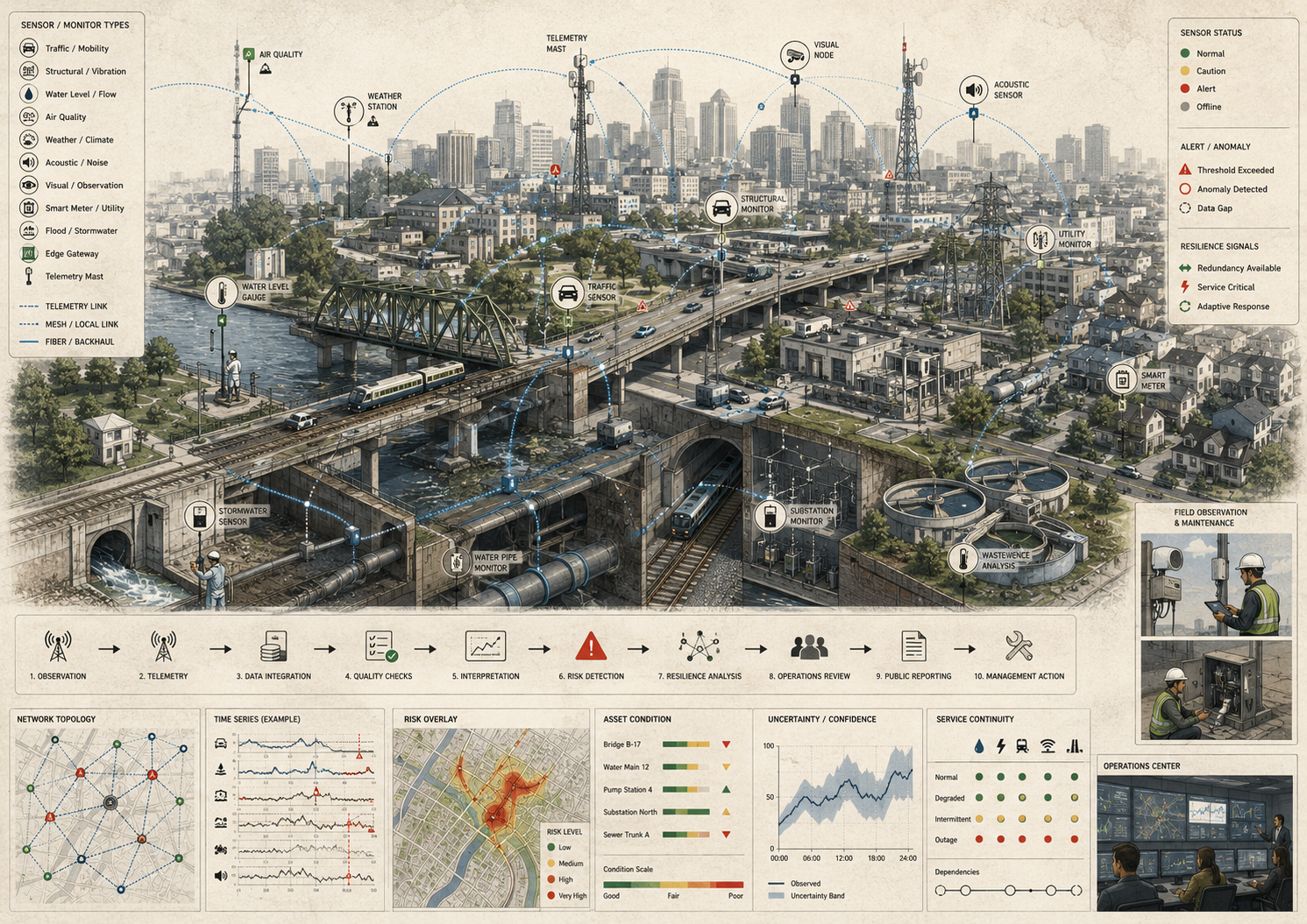
What Are Urban Sensor Networks and Infrastructure Monitoring?
Urban sensor networks are distributed systems of devices and instruments that collect data about the condition, behavior, and performance of urban environments and infrastructure. These networks may include traffic sensors, smart meters, air-quality stations, weather sensors, flood gauges, bridge monitors, acoustic leak detectors, building-management devices, public-lighting controls, wastewater telemetry, drainage sensors, structural-health monitors, public-space counters, and other instruments embedded within the city’s physical fabric.
Infrastructure monitoring refers to the broader process through which the data produced by these networks is interpreted and used to guide maintenance, operations, risk management, public reporting, emergency coordination, and policy. This distinction matters because a sensor network is not automatically a monitoring system. A monitoring system requires metadata, quality assurance, data integration, interpretation, governance, and a pathway to action.
Urban sensing is therefore broader than isolated measurement. A single device can capture a reading, but an urban sensor network creates the possibility of distributed, comparative, and time-sensitive awareness across a wider system. This matters because city infrastructure is not static. Traffic patterns shift by hour. Flood risk changes with weather. Water pressure varies across the network. Air pollution moves across neighborhoods. Assets degrade unevenly. Infrastructure monitoring becomes valuable when it helps institutions understand these dynamics rather than merely recording discrete events.
Urban sensor networks are best understood as the modernization of the city’s observational capacity. They extend the city’s ability to detect conditions, compare locations, identify anomalies, and relate physical signals to operational decisions. In that sense, they form part of the informational infrastructure of contemporary cities.
Why Cities Need Distributed Urban Observability
Cities need distributed urban observability because urban systems are spatially extensive, operationally interdependent, and often only partially visible through manual oversight. Water systems run below ground. Transport conditions evolve minute by minute. Buildings contain hidden mechanical systems. Heat, noise, air pollution, and flood exposure vary across blocks and neighborhoods. Utility performance, asset degradation, and service disruptions often emerge gradually before they become visible as crises.
This matters because urban governance depends on knowing where conditions are changing, which assets are under stress, where service quality is degrading, and which communities are exposed. A city that relies only on periodic inspection or complaint-driven awareness remains largely reactive. It may detect failure after it becomes disruptive rather than while it is still manageable. By contrast, distributed sensing can help reveal early warning signals, local variations, and cross-system interactions that would otherwise remain obscure.
Observability also matters because cities increasingly face compound risks. Heat waves interact with energy demand, building performance, public health, and public space. Intense rainfall affects drainage, mobility, water quality, housing, and emergency access. Congestion can worsen emissions, emergency response, travel reliability, and public exposure simultaneously. Sensor networks can make these coupled conditions more legible, helping cities interpret infrastructure not as isolated sectors but as interconnected systems under stress.
| Urban Condition | Observability Need | Failure If Missing |
|---|---|---|
| Distributed infrastructure assets | Measure conditions across pipes, roads, bridges, buildings, utilities, and public space. | Asset degradation remains hidden until failure or complaint. |
| Fast-changing operations | Track congestion, transit reliability, drainage levels, equipment status, and service disruptions in time. | Institutions respond after disruptions have already cascaded. |
| Localized environmental exposure | Measure heat, air quality, flooding, noise, and water conditions at neighborhood or corridor scale. | Citywide averages hide unequal exposure and burden. |
| Interdependent services | Link signals across energy, water, transport, communications, and public facilities. | Cross-system failure pathways remain invisible. |
| Aging and climate-stressed assets | Detect early warning signals, maintenance needs, and stress conditions. | Maintenance remains reactive and capital planning loses evidence. |
Distributed urban observability becomes valuable when it allows cities to move from delayed recognition toward earlier, more accountable, and more equitable infrastructure stewardship.
Core Architecture of Urban Sensor Networks
Urban sensor networks can be understood through a layered architecture that links physical sensing to institutional response. Each layer matters because weaknesses in sensing, connectivity, metadata, platform integration, interpretation, cybersecurity, or governance can undermine the whole monitoring system.
Sensing Layer
This layer includes fixed and mobile devices that capture measurements from infrastructure and the urban environment. Sensors may monitor flow, pressure, temperature, vibration, occupancy, motion, emissions, noise, particulate matter, rainfall, water levels, structural strain, energy consumption, equipment state, lighting status, waste levels, or flood depth. Sensor selection should follow the monitoring question, not the other way around.
Connectivity Layer
Signals must move through communications systems such as fiber, cellular networks, wireless sensor networks, low-power wide-area networks, supervisory control environments, satellite links, radio systems, or hybrid urban communications architectures. Without reliable connectivity, measurement remains local rather than systemic. Connectivity must also be resilient enough to operate during the kinds of disruptions the monitoring system is meant to support.
Metadata and Quality Layer
Sensor readings require context. This layer documents device type, location, installation date, asset linkage, calibration status, unit definitions, firmware, drift, latency, missingness, quality flags, and data provenance. Without this layer, cities may receive readings but lack the confidence needed to interpret them responsibly.
Data and Integration Layer
At this layer, sensor outputs are timestamped, aligned, linked to assets or geographies, and integrated with contextual information such as maintenance history, service zones, infrastructure topology, weather conditions, incident records, and public-service data. This is where local readings begin to take on wider urban meaning.
Analytics and Interpretation Layer
This layer includes dashboards, alert systems, anomaly detection, trend analysis, visualization, digital twins, forecasting tools, and operational analytics. It is where raw measurements are translated into awareness, comparison, diagnosis, and action recommendations. Analytical systems should document thresholds, uncertainty, false-positive risk, valid use, and human review requirements.
Decision and Response Layer
Monitoring becomes infrastructurally meaningful only when it shapes action. This may involve dispatching maintenance crews, rerouting traffic, issuing warnings, prioritizing inspections, managing water systems, adjusting building controls, updating public reports, revising capital plans, or strengthening environmental and service-equity interventions.
| Layer | Core Capability | Maturity Question |
|---|---|---|
| Sensing | Device measurement of infrastructure, environmental, service, and asset conditions | Are the right variables being measured at the right scale? |
| Connectivity | Transmission through fiber, cellular, LPWAN, radio, SCADA, satellite, or hybrid networks | Can readings move reliably and securely under normal and disrupted conditions? |
| Metadata and quality | Calibration, drift, uptime, latency, missingness, asset linkage, provenance | Can readings be trusted, interpreted, and compared over time? |
| Data integration | Databases, APIs, geospatial layers, asset systems, service records, interoperability | Can sensor data be connected to infrastructure context? |
| Analytics and interpretation | Anomaly detection, dashboards, alerts, trend analysis, digital twins, forecasting | Can signals be translated into meaningful operational or public knowledge? |
| Governance and response | Maintenance, public reporting, privacy, cybersecurity, rights protections, accountability | Can monitoring outputs lead to legitimate and effective action? |
Together these layers show that urban sensor networks are socio-technical systems linking measurement, interpretation, governance, and institutional action across the city.
Infrastructure Domains and Monitoring Applications
Urban sensor networks span many infrastructure domains, and their value often lies in how they illuminate interdependencies among them. The most mature sensor system in one domain can still leave the city fragile if its data are isolated from service context or from the systems it depends on.
Transport and Streets
Transport sensing may include traffic detectors, connected signals, curb-use monitoring, transit vehicle tracking, parking sensors, pedestrian counts, cycling counts, road-condition sensors, bridge monitors, and incident-detection systems. These systems can improve corridor management, transit operations, safety analysis, pavement maintenance, and the understanding of street use across modes. In dense urban settings, even small shifts in signal timing, bus headways, curb occupancy, or flooding can cascade into wider effects on congestion, emissions, emergency access, and accessibility.
Energy and Buildings
Building-management systems, smart meters, occupancy sensors, thermal monitoring, load sensors, equipment-condition sensors, and distributed energy controls help cities and operators understand energy demand, HVAC performance, grid stress, building comfort, and infrastructure resilience. These systems also matter during heat waves, peak demand, outages, or emergency sheltering, when building performance becomes directly connected to public welfare.
Water, Wastewater, and Stormwater
Pressure sensors, flow meters, tank-level monitors, acoustic leak detectors, rainfall gauges, flood sensors, sewer-level monitors, pump telemetry, and treatment-system data support water quality, network performance, drainage behavior, and infrastructure risk management. In cities, these systems also affect mobility, public health, housing, climate adaptation, and environmental exposure. A drainage sensor is never only a drainage sensor if flooding can also interrupt buses, damage housing, and degrade water quality.
Environmental Monitoring
Air-quality stations, heat sensors, weather systems, noise monitors, hydrological instruments, soil sensors, ecological monitoring devices, and mobile environmental sensors help cities understand exposure, ecological stress, and environmental inequalities across neighborhoods. This is especially important where environmental conditions shape public-health outcomes and service priorities, and where citywide averages conceal highly unequal local conditions.
Civic Assets and Public Space
Lighting systems, waste bins, parks, bridges, schools, libraries, civic facilities, and public buildings can all be instrumented to support safer operations, preventive maintenance, accessibility review, and better understanding of how public space is used and stressed over time. In this domain, monitoring can help cities move beyond reactive repairs toward more systematic stewardship of shared civic assets.
| Domain | Example Sensors | Public or Operational Use |
|---|---|---|
| Transport and streets | Traffic detectors, signal telemetry, transit GPS, bridge vibration sensors, curb sensors | Congestion management, safety, maintenance, emergency access, multimodal planning |
| Energy and buildings | Smart meters, HVAC sensors, thermal sensors, occupancy sensors, equipment monitors | Energy management, heat resilience, public facility readiness, demand response |
| Water and stormwater | Pressure sensors, flow meters, rainfall gauges, flood sensors, sewer-level telemetry | Leak detection, flood warning, drainage operations, water quality, asset management |
| Environmental exposure | Air-quality sensors, heat sensors, noise monitors, hydrological gauges | Public health, environmental justice, climate adaptation, local exposure mapping |
| Civic assets and public space | Lighting status, waste-bin sensors, public-building sensors, park condition monitors | Maintenance, public safety, public space stewardship, service quality |
The key point is that urban sensing becomes more valuable when it supports cross-domain awareness rather than remaining confined to sector-specific instrumentation. Cities rarely fail in neatly separated categories, and the monitoring architecture should reflect that reality.
Data Integration, Platforms, and Urban Interpretation
Sensor networks do not create urban intelligence automatically. Their outputs become useful when cities can integrate, contextualize, and interpret them across institutional and infrastructural boundaries. A city may possess traffic data, air-quality data, flood data, smart-meter data, public-building data, and service-request data, but if those streams remain disconnected, the city’s understanding of infrastructure remains fragmented.
Urban data platforms matter because they allow distributed sensor outputs to be aligned with assets, geographies, incidents, service systems, and governance records. This can support dashboards, maintenance systems, urban observatories, forecasting, digital twins, emergency coordination, and cross-sector planning. Interoperability and common data frameworks are essential at this stage. Otherwise, cities accumulate instrumentation without creating coherent situational awareness.
Interpretation is just as important as storage. Sensor data can be noisy, partial, biased, or misleading when detached from maintenance records, engineering knowledge, spatial context, community knowledge, or operational priorities. Urban monitoring becomes valuable not because it produces more signals, but because it helps institutions distinguish routine variation from meaningful change and connect observation to action.
| Data Stage | Function | Governance Value |
|---|---|---|
| Raw sensor reading | Records a value at a device, location, and time. | Provides the basic observation unit. |
| Quality-controlled telemetry | Applies calibration status, missingness checks, latency review, and validity flags. | Improves trust and interpretability. |
| Asset-linked record | Connects a reading to an asset, service zone, infrastructure network, or public facility. | Turns readings into infrastructure context. |
| Indicator or alert | Summarizes status, anomaly, threshold, trend, or exposure condition. | Supports public reporting, maintenance, response, or planning. |
| Institutional action | Connects evidence to work orders, emergency response, public communication, or investment. | Turns sensing into public value. |
Urban sensor infrastructure should therefore be evaluated by the strength of the interpretive chain, not simply by the volume of data collected.
Environmental Sensing, Public Health, and Urban Exposure
One of the most important roles of urban sensor networks is to make uneven urban exposure more visible. Air pollution, heat, flooding, noise, water-quality risk, smoke, traffic exposure, and drainage failure are rarely distributed evenly across the city. They often vary by street form, traffic intensity, land use, housing conditions, tree canopy, infrastructure quality, elevation, industrial proximity, and neighborhood vulnerability. Distributed sensing can reveal these inequalities in ways that citywide averages cannot.
This matters because public health is tied closely to environmental infrastructure. Air-quality monitoring can support transport policy, emissions control, health-risk communication, and environmental justice review. Heat sensing can inform cooling strategies, tree-canopy planning, building retrofits, and emergency preparedness. Flood sensing can improve warnings, drainage operations, road closures, and resilience planning. Water-quality sensing can strengthen public-health protection and regulatory assurance.
Urban sensor networks therefore do more than support engineering efficiency. They can change what cities are able to see about risk, exposure, and unequal infrastructure performance, which in turn can influence public priorities and institutional accountability.
| Environmental Signal | Urban Interpretation | Possible Public Response |
|---|---|---|
| PM2.5, NO2, ozone, or smoke | Localized air-quality exposure and traffic or industrial burden | Health advisory, emissions review, transport policy, community reporting |
| Surface and air temperature | Urban heat islands, cooling gaps, building vulnerability, outdoor-worker risk | Cooling centers, canopy investment, building retrofits, heat action plans |
| Rainfall, water level, and flood depth | Stormwater stress, road closure risk, drainage bottlenecks, flood exposure | Flood warning, pump management, route closure, drainage investment |
| Noise levels | Transport, industrial, construction, or nightlife exposure | Planning review, enforcement, public-health analysis, mitigation design |
| Water pressure or quality | Network condition, service reliability, contamination risk, equity of service | Maintenance dispatch, public-health communication, infrastructure upgrade |
Environmental sensing becomes most powerful when it is linked to social exposure, infrastructure conditions, and accountable public action rather than treated as isolated environmental data collection.
Asset Stewardship, Maintenance, and Lifecycle Awareness
Urban sensor networks are also important because infrastructure usually degrades gradually rather than failing all at once. Bridges accumulate stress. Pipes leak before they rupture. Pumps lose efficiency before they stop. Pavement deteriorates before it becomes dangerous. Buildings overheat or drift out of calibration before major breakdown. Drainage systems clog before flooding becomes visible. Monitoring systems help cities detect these trajectories earlier.
This is where sensing intersects with stewardship. Good monitoring improves the temporal intelligence of infrastructure management by allowing cities and operators to move from crisis response toward preventive, predictive, or condition-informed maintenance. It can help prioritize inspection, improve work-order timing, reduce emergency repairs, strengthen lifecycle planning, and make replacement decisions more evidence-based.
Lifecycle awareness is particularly important in cities where old and new systems coexist. Legacy assets may be operating under new climate or usage conditions, while new digital assets introduce their own maintenance burdens, calibration needs, software dependencies, firmware updates, cybersecurity requirements, and vendor risks. Sensor networks do not eliminate these complexities, but they can make them more visible.
| Asset or System | Monitoring Signal | Stewardship Use |
|---|---|---|
| Bridges and structures | Vibration, strain, displacement, load, corrosion, inspection anomalies | Prioritized inspection, structural health monitoring, renewal planning |
| Water networks | Pressure, flow, acoustic leaks, pump status, tank levels, water quality | Leak detection, pressure management, maintenance dispatch, capital renewal |
| Stormwater and drainage | Rainfall, water levels, pump status, blockage indicators, flood depth | Flood response, pump operations, cleaning schedules, capacity upgrades |
| Buildings and public facilities | Temperature, humidity, occupancy, energy use, HVAC status, indoor air quality | Comfort, efficiency, health protection, emergency shelter readiness |
| Roads and public space | Surface condition, lighting status, waste levels, pedestrian flow, incident reports | Maintenance prioritization, safety improvements, public-space stewardship |
Monitoring becomes stewardship infrastructure when it helps institutions care for assets across their lifecycle rather than merely detect failure after the fact.
Risk, Cybersecurity, and Sensor-System Vulnerability
Urban sensor networks expand capability, but they also introduce new forms of risk. Sensors can fail, drift, lose calibration, lose power, transmit erroneous readings, or be poorly maintained. Communications networks can degrade or be interrupted. Data pipelines can be corrupted. Platforms can become overloaded, poorly secured, or dependent on vendors. In digitally mediated cities, the loss of observability can itself become an operational problem.
Cybersecurity is especially important because sensor systems increasingly connect to critical infrastructure, civic services, and city platforms. A poorly governed monitoring environment can create openings for manipulation, surveillance abuse, false confidence, data exfiltration, denial of service, or systemic disruption. The more urban services depend on shared digital layers, the more those layers require secure architecture, clear accountability, and resilient fallback procedures.
Risk also arises from concentration and opacity. A city may improve coordination through centralized platforms while simultaneously increasing vendor dependence, institutional complexity, or the consequences of a single point of failure. Urban monitoring therefore requires resilience, redundancy, explainability, public oversight, and fallback capacity rather than mere expansion of data collection.
| Risk Category | Failure Mode | Mitigation Requirement |
|---|---|---|
| Device failure | Sensors drift, lose calibration, lose power, or fail silently. | Device-health monitoring, calibration logs, redundancy, field inspection |
| Telemetry failure | Signals are delayed, dropped, duplicated, or unavailable during disruption. | Latency tracking, failover communications, offline procedures |
| Data-quality failure | Readings are misinterpreted because missingness, units, or metadata are not documented. | Quality flags, metadata schema, provenance, validation tests |
| Cybersecurity failure | Sensor networks, gateways, APIs, or platforms are manipulated or disrupted. | Authentication, encryption, segmentation, logging, incident response |
| Privacy and legitimacy failure | Urban sensing expands surveillance or public mistrust without clear safeguards. | Data minimization, privacy review, public-purpose documentation, accountability |
| Platform concentration | Vendor lock-in or centralized platform failure weakens city control and resilience. | Interoperability, portability, open standards, resilience architecture |
Urban sensor networks should therefore be designed as resilient public infrastructure, not merely as connected devices or platform services.
Governance, Legitimacy, and Institutional Capacity
Urban sensing is a governance problem as much as a technical one. Cities must decide what to measure, where to place sensors, how to govern access, how to protect rights, how to finance operations, how to avoid vendor lock-in, how to manage retention, how to communicate uncertainty, and how to ensure that monitoring serves public rather than merely administrative or commercial purposes. These decisions shape what becomes visible and what remains ignored.
Legitimacy matters because sensor networks can affect privacy, surveillance, participation, and trust in public institutions. A city that senses extensively without explaining purposes, safeguards, or public value may weaken legitimacy even while improving operational visibility. Urban digital transformation therefore has to be grounded in rights, inclusion, accountability, and public value rather than silent extraction of data from the urban environment.
Institutional capacity matters just as much. A city can procure sophisticated sensor systems and still fail to improve infrastructure governance if agencies cannot interpret the data, if maintenance workflows are weak, if procurement creates vendor lock-in, if staff cannot maintain systems, or if no one is empowered to act on emerging signals. Urban sensor networks are therefore not only technical systems. They are institutional systems whose quality depends on governance, skills, coordination, finance, public accountability, and long-term maintenance.
| Capability | Purpose | Evidence Artifact |
|---|---|---|
| Public-purpose definition | Defines why sensing exists and which public outcomes it supports. | Public-purpose statement, monitoring objective manifest |
| Rights and privacy governance | Protects against surveillance abuse, over-collection, weak retention rules, and unclear access. | Privacy review, access-control policy, retention policy, data minimization plan |
| Interoperability and data stewardship | Prevents fragmentation across vendors, agencies, and data systems. | API documentation, shared identifiers, data catalog, portability plan |
| Operational response authority | Ensures sensor findings lead to maintenance, dispatch, warning, or public reporting where appropriate. | Response protocol, work-order integration, governance log |
| Cybersecurity and resilience | Protects the monitoring architecture and ensures fallback capacity. | Security architecture, incident response plan, failover test, audit log |
| Public accountability | Explains what is measured, what is not measured, who uses the data, and how communities can contest or interpret it. | Public evidence package, community feedback record, transparency report |
The governance question is whether urban sensing strengthens public capability and accountability, or whether it simply produces more data without public legitimacy.
Measurement, Indicators, and Urban Monitoring Quality
Measurement matters because cities need ways to assess whether sensor systems are actually improving urban understanding and infrastructure performance. Relevant indicators may include coverage, uptime, latency, calibration status, data completeness, anomaly-detection accuracy, maintenance response time, asset-condition visibility, environmental exposure mapping, cybersecurity posture, privacy safeguards, and usefulness of monitoring outputs in operational decisions.
But monitoring quality cannot be reduced to sensor counts or dashboard activity. A city may install many devices and still remain weak in interpretation, maintenance, public legitimacy, or service improvement. Urban monitoring should therefore be evaluated in terms of whether it improves service quality, risk awareness, infrastructure stewardship, exposure visibility, and accountable public reasoning rather than through deployment volume alone.
Indicators are most useful when they help cities learn, prioritize, and govern more effectively. They are less useful when they turn urban sensing into a technocratic performance ritual detached from material improvements in infrastructure and urban life.
| Metric Type | Example Measure | Interpretive Caution |
|---|---|---|
| Coverage | Share of relevant assets, geography, service zones, or exposure areas monitored | Coverage may not align with highest risk or vulnerability. |
| Uptime and latency | Device availability, telemetry delay, communication dropouts, data freshness | Real-time data may still be misleading if calibration is weak. |
| Calibration and quality | Calibration status, drift detection, missingness, range checks, quality flags | Unflagged data can produce false confidence. |
| Interoperability | Use of common identifiers, APIs, units, metadata, and asset linkages | Non-interoperable systems remain difficult to coordinate. |
| Operational uptake | Alerts converted into inspections, work orders, public reports, or response actions | Monitoring may detect problems without institutional consequence. |
| Public legitimacy | Privacy safeguards, public-purpose documentation, transparency, complaint pathways | Technically useful systems can still undermine trust. |
Good monitoring performance measures the health of the entire observation-action chain, not only the number of devices deployed.
Deployment Readiness Gate
Before urban sensor networks are used for infrastructure operations, maintenance prioritization, public reporting, exposure analysis, emergency management, digital twin workflows, or resilience planning, they should pass a readiness gate. The purpose is not to delay useful monitoring. It is to confirm that sensor outputs are supported by documented objectives, reliable devices, secure communications, usable metadata, data-quality review, rights protections, and response pathways.
| Readiness Check | Pass Condition | Evidence |
|---|---|---|
| Monitoring purpose | Urban domains, variables, use cases, thresholds, and decision pathways are defined. | Urban sensing objective manifest, indicator catalog |
| Sensor and asset inventory | Devices, locations, assets, service zones, operators, and operational status are documented. | Sensor inventory, asset linkage table, GeoJSON layer |
| Telemetry reliability | Connectivity, latency, uptime, failover, and outage behavior are documented and monitored. | Telemetry log, communications architecture, failover plan |
| Data quality and calibration | Calibration, missingness, drift, quality flags, units, and provenance are tracked. | Calibration log, quality-control schema, device-health table |
| Data integration | Sensor records are standardized, timestamped, linked to assets, and interoperable across systems. | SQL schema, API documentation, data catalog, shared identifiers |
| Cybersecurity and resilience | Authentication, segmentation, logging, incident response, and fallback procedures are defined. | Security architecture, incident response plan, audit log |
| Rights and public legitimacy | Privacy, access, retention, public purpose, and accountability safeguards are documented. | Privacy review, public evidence package, data governance policy |
| Response and stewardship | Monitoring outputs are connected to maintenance, inspection, warning, reporting, or planning action. | Response protocol, work-order integration, governance log |
A sensor network that cannot pass this readiness gate may still collect data, but its outputs should be treated cautiously when used for public claims, operational automation, or infrastructure investment decisions.
Data and Configuration Artifacts
The companion repository can use a data-first structure so urban sensing claims can be examined rather than merely asserted. Each artifact has a specific role in making the observability chain reconstructable across devices, assets, telemetry, metadata, data quality, indicators, governance, and response.
| Artifact | File | Purpose |
|---|---|---|
| Urban sensing objective manifest | config/urban_sensing_objective.yml |
Defines domains, variables, use cases, valid-use limits, and public evidence requirements. |
| Sensor inventory | data/urban_sensor_inventory.csv |
Tracks devices, domains, locations, operators, assets, variables, and operational status. |
| Telemetry records sample | data/urban_sensor_telemetry_sample.csv |
Stores timestamped sensor readings with variables, units, quality flags, and latency. |
| Asset linkage table | data/sensor_asset_linkage.csv |
Links sensors to infrastructure assets, service zones, responsible agencies, and criticality. |
| Calibration and device-health log | data/calibration_device_health_log.csv |
Tracks calibration, drift, battery, uptime, firmware, maintenance, and device-health status. |
| Coverage and exposure review | data/coverage_exposure_review.csv |
Evaluates whether monitoring coverage captures high-risk assets, exposed communities, and service zones. |
| Indicator and alert catalog | data/urban_sensor_indicator_catalog.csv |
Documents thresholds, anomaly logic, alert categories, and response interpretation. |
| SQL schema | sql/schema.sql |
Creates a local SQLite database for urban sensor and infrastructure monitoring records. |
These artifacts are designed to make urban observability auditable. They can be replaced with institutional data sources later, but the scaffold makes the logic of urban sensing, signal quality, interpretation, and action explicit from the beginning.
Mathematical Lens: Sensor Quality, Urban Observability, and Response
A lightweight mathematical lens helps distinguish data collection from observability. The point is not to reduce urban monitoring to a single score, but to make visible the relationships among sensor quality, coverage, signal interpretation, infrastructure risk, and institutional response.
A_{i,t} = X_{i,t} – B_i
\]
Interpretation: A sensor anomaly compares a current observation with an expected baseline. The baseline may represent normal traffic, pressure, temperature, vibration, water level, or another domain-specific condition.
Q_i =
w_1U_i +
w_2K_i +
w_3M_i +
w_4L_i +
w_5P_i
\]
Interpretation: Sensor quality depends on uptime \(U\), calibration \(K\), metadata completeness \(M\), latency \(L\), and provenance \(P\).
C_z = \frac{N_{\mathrm{observed},z}}{N_{\mathrm{needed},z}}
\]
Interpretation: Coverage should be evaluated against the monitoring purpose. A zone may appear covered geographically while still under-monitoring high-risk assets or vulnerable populations.
O_{\mathrm{urban}} =
\alpha Q +
\beta C +
\gamma I +
\delta S +
\eta G
\]
Interpretation: Urban observability depends on quality \(Q\), coverage \(C\), interoperability \(I\), service relevance \(S\), and governance capacity \(G\).
This mathematical framing should be used as a structured diagnostic, not as a substitute for engineering judgment, public governance, cybersecurity review, privacy assessment, or community knowledge.
Python Workflow: Urban Sensor Network and Infrastructure Monitoring Review
The Python workflow in the companion repository can read sensor inventories, telemetry records, asset linkages, calibration logs, coverage reviews, and indicator catalogs; compute sensor-quality scores, coverage flags, threshold exceedances, latency risks, and observability review flags; and export a governance-ready watchlist. The sample below illustrates the core logic.
from pathlib import Path
import pandas as pd

ARTICLE_DIR = Path("articles/urban-sensor-networks-infrastructure-monitoring-observability-risk-and-resilience")
DATA_DIR = ARTICLE_DIR / "data"
OUTPUT_DIR = ARTICLE_DIR / "outputs"
OUTPUT_DIR.mkdir(parents=True, exist_ok=True)

sensors = pd.read_csv(DATA_DIR / "urban_sensor_inventory.csv")
telemetry = pd.read_csv(DATA_DIR / "urban_sensor_telemetry_sample.csv", parse_dates=["timestamp"])
linkage = pd.read_csv(DATA_DIR / "sensor_asset_linkage.csv")
health = pd.read_csv(DATA_DIR / "calibration_device_health_log.csv")
coverage = pd.read_csv(DATA_DIR / "coverage_exposure_review.csv")
indicators = pd.read_csv(DATA_DIR / "urban_sensor_indicator_catalog.csv")

review = (
    telemetry
    .merge(sensors, on="sensor_id", how="left")
    .merge(linkage, on="sensor_id", how="left")
    .merge(health, on="sensor_id", how="left")
    .merge(coverage, on="service_zone_id", how="left")
    .merge(indicators, on=["domain", "variable"], how="left")
)

review["threshold_exceeded"] = review["value"] >= review["threshold_value"]

review["latency_score"] = (
    1 - (review["latency_seconds"] / review["latency_seconds"].max())
).clip(lower=0, upper=1)

review["sensor_quality_score"] = (
    0.25 * review["uptime_score"] +
    0.20 * review["calibration_score"] +
    0.20 * review["metadata_score"] +
    0.20 * review["latency_score"] +
    0.15 * review["provenance_score"]
)

review["coverage_gap_score"] = 1 - review["coverage_score"]

review["urban_observability_score"] = (
    0.30 * review["sensor_quality_score"] +
    0.20 * review["coverage_score"] +
    0.20 * review["interoperability_score"] +
    0.15 * review["service_relevance_score"] +
    0.15 * review["governance_response_score"]
)

review["monitoring_review_flag"] = (
    (review["threshold_exceeded"]) |
    (review["sensor_quality_score"] < 0.75) |
    (review["coverage_gap_score"] >= 0.35) |
    (review["latency_seconds"] > review["max_acceptable_latency_seconds"]) |
    (review["governance_response_score"] < 0.60)
)

review.to_csv(OUTPUT_DIR / "urban_sensor_network_monitoring_review.csv", index=False)

watchlist = (
    review[review["monitoring_review_flag"]]
    .sort_values(
        ["threshold_exceeded", "coverage_gap_score", "sensor_quality_score"],
        ascending=[False, False, True]
    )
)

watchlist.to_csv(OUTPUT_DIR / "urban_sensor_governance_watchlist.csv", index=False)

print(watchlist[[
    "sensor_id",
    "asset_id",
    "domain",
    "variable",
    "value",
    "threshold_value",
    "sensor_quality_score",
    "coverage_gap_score",
    "urban_observability_score"
]])
This workflow is intentionally transparent. It allows analysts to see whether monitoring concern arises from threshold exceedance, sensor quality, latency, coverage gaps, interoperability, service relevance, or weak governance response.
R Workflow: Sensor Coverage, Quality, and Infrastructure Reporting
The R workflow can summarize urban sensing by domain, evaluate monitoring coverage, identify threshold exceedances, and report on sensor quality and observability performance for infrastructure teams, city agencies, and public evidence packages.
library(readr)
library(dplyr)

article_dir <- "articles/urban-sensor-networks-infrastructure-monitoring-observability-risk-and-resilience"
data_dir <- file.path(article_dir, "data")
output_dir <- file.path(article_dir, "outputs")
dir.create(output_dir, recursive = TRUE, showWarnings = FALSE)

sensors <- read_csv(file.path(data_dir, "urban_sensor_inventory.csv"), show_col_types = FALSE)
telemetry <- read_csv(file.path(data_dir, "urban_sensor_telemetry_sample.csv"), show_col_types = FALSE)
linkage <- read_csv(file.path(data_dir, "sensor_asset_linkage.csv"), show_col_types = FALSE)
health <- read_csv(file.path(data_dir, "calibration_device_health_log.csv"), show_col_types = FALSE)
coverage <- read_csv(file.path(data_dir, "coverage_exposure_review.csv"), show_col_types = FALSE)
indicators <- read_csv(file.path(data_dir, "urban_sensor_indicator_catalog.csv"), show_col_types = FALSE)

review <- telemetry %>%
  left_join(sensors, by = "sensor_id") %>%
  left_join(linkage, by = "sensor_id") %>%
  left_join(health, by = "sensor_id") %>%
  left_join(coverage, by = "service_zone_id") %>%
  left_join(indicators, by = c("domain", "variable")) %>%
  mutate(
    threshold_exceeded = value >= threshold_value,
    latency_score = pmax(0, pmin(1, 1 - latency_seconds / max(latency_seconds, na.rm = TRUE))),
    sensor_quality_score =
      0.25 * uptime_score +
      0.20 * calibration_score +
      0.20 * metadata_score +
      0.20 * latency_score +
      0.15 * provenance_score,
    coverage_gap_score = 1 - coverage_score,
    urban_observability_score =
      0.30 * sensor_quality_score +
      0.20 * coverage_score +
      0.20 * interoperability_score +
      0.15 * service_relevance_score +
      0.15 * governance_response_score,
    monitoring_review_flag =
      threshold_exceeded |
      sensor_quality_score < 0.75 |
      coverage_gap_score >= 0.35 |
      latency_seconds > max_acceptable_latency_seconds |
      governance_response_score < 0.60
  )

domain_summary <- review %>%
  group_by(domain) %>%
  summarise(
    sensors = n_distinct(sensor_id),
    observations = n(),
    threshold_exceedances = sum(threshold_exceeded, na.rm = TRUE),
    mean_sensor_quality = mean(sensor_quality_score, na.rm = TRUE),
    mean_coverage_gap = mean(coverage_gap_score, na.rm = TRUE),
    mean_observability = mean(urban_observability_score, na.rm = TRUE),
    review_flags = sum(monitoring_review_flag, na.rm = TRUE),
    .groups = "drop"
  ) %>%
  arrange(desc(review_flags), desc(mean_coverage_gap))

write_csv(review, file.path(output_dir, "urban_sensor_monitoring_review_report.csv"))
write_csv(domain_summary, file.path(output_dir, "urban_sensor_domain_summary.csv"))

print(domain_summary)
The purpose is not to produce a definitive smart-city rating. It is to demonstrate how urban sensor records, coverage, quality, latency, thresholds, and governance response can be made reproducible and auditable.
Systems Code: Urban Sensing, Edge Monitoring, and Infrastructure Observability
The companion repository can extend the article into a reproducible systems scaffold. Python and R support analytical review; SQL stores evidence; YAML files define objectives and policies; GeoJSON provides spatial placeholders; TypeScript can support dashboard interfaces; Go can support monitoring-status APIs; Rust can support strict telemetry validation; C can support sensor-quality calculations; Fortran can support numerical observability routines; MicroPython can support low-power urban sensing nodes; PYNQ and HDL can support hardware-assisted stream validation where appropriate.
| Directory | Role | Example Use |
|---|---|---|
python/ |
Sensor-quality scoring, coverage review, threshold checks, governance watchlists | Compute urban observability and monitoring review flags |
r/ |
Domain summaries, sensor coverage reports, monitoring performance review | Summarize sensor quality and coverage by infrastructure domain |
sql/ |
Evidence tables and auditable queries | Join sensors, telemetry, asset linkages, health records, indicators, and governance logs |
c/ and embedded_c/ |
Low-level sensor-quality checks and embedded monitoring logic | Validate edge telemetry, battery, range, latency, and threshold flags |
rust/ |
Strict validation and CLI scaffolding | Validate sensor records, quality scores, and domain-specific thresholds |
go/ |
Monitoring-status API scaffold | Expose device, asset, or infrastructure monitoring status over a lightweight endpoint |
fortran/ |
Numerical observability calculations | Prototype sensor quality, anomaly, and observability scoring |
micropython/ |
Edge sensing-node scaffold | Prototype low-power flood, air-quality, heat, or asset-status telemetry |
pynq/ and hdl/ |
Hardware-assisted stream validation | Prototype FPGA checks for threshold flags, latency status, and quality signals |
typescript/ |
Dashboard/interface scaffold | Display sensor quality, coverage gaps, threshold events, and governance review flags |
The code should be understood as an engineering scaffold for reproducible urban sensing workflows, not as a replacement for certified infrastructure operations, public-safety authority, cybersecurity review, privacy review, or city governance processes.
GitHub Repository
The companion repository can house the reproducible data, code, schemas, validation tools, and systems-engineering examples that support this article’s urban sensor network and infrastructure monitoring framework.
The companion repository contains reproducible scaffolding for urban sensor inventories, telemetry records, asset linkages, calibration and device-health logs, coverage and exposure reviews, threshold and indicator catalogs, SQL-backed observability archives, embedded monitoring examples, and multi-language urban sensing workflows.
Testing and Validation
Testing urban sensor networks requires more than checking whether devices transmit data or dashboards load. Validation should examine whether sensors are properly placed, calibrated, linked to assets, secured, monitored for drift, integrated with metadata, interpreted correctly, and connected to response workflows. It should also assess whether coverage captures high-risk infrastructure and exposed communities rather than only convenient or high-value locations.
| Validation Area | Test Question | Failure Signal |
|---|---|---|
| Sensor inventory | Are devices, locations, variables, operators, firmware, and status documented? | Readings appear without clear device context. |
| Asset and service linkage | Are sensors connected to assets, service zones, infrastructure domains, and responsible agencies? | Telemetry cannot be translated into infrastructure action. |
| Calibration and device health | Are calibration, drift, battery, uptime, maintenance, and replacement status tracked? | Sensor outputs generate false confidence. |
| Telemetry reliability | Are latency, dropouts, communication failures, and failover behavior monitored? | Data appear current but are delayed, missing, or incomplete. |
| Cybersecurity | Are devices, gateways, APIs, platforms, and credentials protected? | Sensor networks become attack surfaces for infrastructure disruption. |
| Coverage and equity | Does sensor placement capture vulnerable communities, critical services, and high-risk assets? | Monitoring improves visibility where systems are already well observed. |
| Response integration | Are alerts connected to maintenance, inspection, public reporting, or emergency response? | Monitoring detects problems but produces no action. |
Validation should be repeated after sensor replacement, firmware updates, platform migration, network changes, new cybersecurity findings, major infrastructure events, and changes in public reporting or operational workflows.
Operational Signals and Urban Sensor Network Observability
Urban sensor network observability means being able to see whether the monitoring system itself is functioning as trustworthy public infrastructure. This includes device uptime, telemetry latency, missingness, calibration status, battery status, firmware status, alert volumes, false-positive rates, threshold exceedances, platform health, cybersecurity events, coverage gaps, and response closure.
| Signal | What It Reveals | Operational Use |
|---|---|---|
| Device uptime | Whether sensors are producing expected records | Maintenance scheduling and monitoring reliability review |
| Telemetry latency | Whether readings arrive quickly enough for the intended use | Operations, alerting, public reporting, and emergency coordination |
| Calibration and drift | Whether readings remain credible over time | Field service, quality assurance, sensor replacement |
| Missingness and quality flags | Whether records contain gaps, suspect values, or failed readings | Data-quality review and dashboard caveats |
| Coverage gap score | Whether high-risk assets, service zones, or exposed communities are under-observed | Network expansion, equity review, risk prioritization |
| Alert-to-response closure | Whether monitoring findings lead to inspection, maintenance, reporting, or action | Governance accountability and operational improvement |
| Security events | Whether devices, APIs, gateways, or platforms show suspicious behavior | Cybersecurity response and resilience planning |
Urban sensor network observability is strongest when the city can monitor not only infrastructure conditions, but also the health, reliability, legitimacy, and actionability of the monitoring system itself.
Engineer and Researcher Checklist
- Define the infrastructure domains, variables, thresholds, service questions, and public purposes the sensor network must support.
- Document sensors, locations, operators, firmware, communication modes, calibration status, and operational status.
- Link each sensor to assets, service zones, geographies, responsible agencies, and response workflows.
- Track uptime, latency, missingness, drift, battery, calibration, firmware updates, and quality flags.
- Evaluate monitoring coverage against high-risk assets, vulnerable communities, service gaps, and environmental exposure.
- Use shared identifiers, interoperable schemas, APIs, metadata, and data catalogs to avoid platform fragmentation.
- Protect sensor networks through cybersecurity architecture, access controls, logging, segmentation, and incident response.
- Document privacy, rights, retention, public purpose, and public accountability safeguards.
- Connect alerts and indicators to inspection, maintenance, public reporting, emergency response, or capital planning.
- Publish evidence packages that explain what is measured, what is not measured, how data are validated, and who is responsible.
This checklist is intentionally practical. It keeps urban sensing focused on public observability, infrastructure stewardship, and accountable action rather than device deployment alone.
Where This Fits in the Series
Urban sensor networks and infrastructure monitoring connect several major threads within the Intelligent Infrastructure Systems knowledge series. They rely on digital infrastructure to move data, cyber-physical systems to connect software and physical assets, environmental monitoring to detect exposure, data platforms to integrate records, water and transportation systems to support sector-specific sensing, security systems to protect observability, and governance systems to turn monitoring into legitimate public action.
This article therefore functions as a bridge between physical infrastructure and public intelligence. It shows that intelligent infrastructure is not only about automation or optimization. It is also about whether cities can observe their own systems reliably enough, securely enough, and equitably enough to maintain services, detect risk, and govern responsibly under changing conditions.
Future Directions
The future of urban sensor networks will likely involve denser environmental monitoring, more connected utility sensing, wider use of edge processing, stronger integration with urban observatories and digital twins, and greater use of sensor data in climate adaptation, public-health protection, preventive maintenance, and service-continuity planning. It will also likely involve stronger attention to data governance, public legitimacy, cybersecurity, interoperability, and the risks of over-centralized platform dependence.
The deeper challenge, however, is not simply building more instrumented cities. It is building cities whose sensing systems improve public capability without undermining trust, rights, or institutional clarity. Urban sensor networks will matter most where they strengthen urban stewardship, resilience, exposure visibility, and service quality rather than merely multiplying streams of data. The long-run goal is not ubiquitous sensing for its own sake. It is an urban infrastructure system that can detect conditions early enough, interpret them clearly enough, and respond effectively enough to support safer, fairer, and more resilient cities.
Future work should therefore move beyond sensor deployment toward governed observability systems: secure, interoperable, documented, inclusive, accountable, and connected to public action.
Related Articles
- Digital Infrastructure Systems
- Cyber-Physical Infrastructure Systems
- Infrastructure Monitoring and Sensor Integration
- Infrastructure Data Platforms and Analytics
- Smart City Infrastructure Systems
- Intelligent Water Infrastructure Systems
- Environmental Monitoring Systems
- Intelligent Transportation Networks
- Infrastructure Security and Cyber Resilience
- Infrastructure Governance and Policy Systems
These connections are substantive rather than decorative. Urban sensor networks are not an isolated smart-city accessory, but a systems domain connecting measurement, maintenance, environmental awareness, cyber-physical infrastructure, resilience, and public governance.
Further Reading
- United Nations Human Settlements Programme (UN-Habitat) (2025) International Guidelines on People-Centred Smart Cities. Available at: https://unhabitat.org/sites/default/files/2025/03/international_guidelines_on_people_centred_smart_cities_clean_4.3.2025.pdf.
- United Nations Human Settlements Programme (UN-Habitat) (2024) World Smart Cities Outlook 2024. Available at: https://unhabitat.org/world-smart-cities-outlook-2024.
- Organisation for Economic Co-operation and Development (OECD) (2024) Smart City Data Governance. Available at: https://www.oecd.org/en/publications/smart-city-data-governance_e57ce301-en.html.
- Organisation for Economic Co-operation and Development (OECD) (2021) Innovation and Data Use in Cities. Available at: https://www.oecd.org/en/publications/innovation-and-data-use-in-cities_9f53286f-en.html.
- United for Smart Sustainable Cities (U4SSC) (n.d.) United for Smart Sustainable Cities. Available at: https://u4ssc.itu.int/.
- International Telecommunication Union (ITU) (2023) Enabling Digital Transformation in Smart Sustainable Cities. Available at: https://www.itu.int/en/publications/Documents/tsb/2023-Master-plan-Enabling-digital-transformation-smart-cities/files/downloads/23-00351_Master-plan-Enabling-digital-transformation-smart-cities.pdf.
- World Bank (n.d.) Global Smart City Partnership Program. Available at: https://www.worldbank.org/en/programs/global-smart-city-partnership-program.
- World Bank (2017) Big Data and Thriving Cities. Available at: https://documents1.worldbank.org/curated/en/842181488514624285/pdf/113147-WP-P152206-PUBLIC-WBG-BigData-URBAN-Final-online.pdf.
References
- International Telecommunication Union (ITU) (2022) Recommendation ITU-T Y.4903: Key performance indicators for smart sustainable cities to assess the achievement of sustainable development goals. Available at: https://www.itu.int/rec/dologin_pub.asp?id=T-REC-Y.4903-202203-I%21%21PDF-E&lang=e&type=items.
- International Telecommunication Union (ITU) (2023) Enabling Digital Transformation in Smart Sustainable Cities. Geneva: ITU. Available at: https://www.itu.int/en/publications/Documents/tsb/2023-Master-plan-Enabling-digital-transformation-smart-cities/files/downloads/23-00351_Master-plan-Enabling-digital-transformation-smart-cities.pdf.
- Organisation for Economic Co-operation and Development (OECD) (2021) Innovation and Data Use in Cities. Paris: OECD. Available at: https://www.oecd.org/content/dam/oecd/en/publications/reports/2021/12/innovation-and-data-use-in-cities_f621a0a6/9f53286f-en.pdf.
- Organisation for Economic Co-operation and Development (OECD) (2024) Smart City Data Governance. Paris: OECD. Available at: https://www.oecd.org/content/dam/oecd/en/publications/reports/2023/10/smart-city-data-governance_fc19e878/e57ce301-en.pdf.
- United for Smart Sustainable Cities (U4SSC) (n.d.) United for Smart Sustainable Cities. Available at: https://u4ssc.itu.int/.
- United Nations Human Settlements Programme (UN-Habitat) (2024) World Smart Cities Outlook 2024. Nairobi: UN-Habitat. Available at: https://unhabitat.org/world-smart-cities-outlook-2024.
- United Nations Human Settlements Programme (UN-Habitat) (2025) International Guidelines on People-Centred Smart Cities. Available at: https://unhabitat.org/sites/default/files/2025/03/international_guidelines_on_people_centred_smart_cities_clean_4.3.2025.pdf.
- World Bank (n.d.) Global Smart City Partnership Program. Available at: https://www.worldbank.org/en/programs/global-smart-city-partnership-program.
- World Bank (2017) Big Data and Thriving Cities. Washington, DC: World Bank. Available at: https://documents1.worldbank.org/curated/en/842181488514624285/pdf/113147-WP-P152206-PUBLIC-WBG-BigData-URBAN-Final-online.pdf.