
Last Updated May 14, 2026
Intelligent transportation networks are transport systems in which physical infrastructure, vehicles, communications systems, sensors, data platforms, operational control, and public governance are integrated to improve mobility, safety, accessibility, reliability, efficiency, and resilience. They include roads, rail systems, public transit, freight corridors, cycling and pedestrian infrastructure, traffic management systems, curb and parking systems, connected vehicles, digital ticketing, logistics platforms, and the institutional arrangements that coordinate them. In this sense, intelligent transportation is not simply about adding technology to roads. It is about making transport networks more observable, more coordinated, and more responsive to human and system needs.
Transport systems have always depended on infrastructure, but the conditions under which that infrastructure operates have become more complex. Rapid urbanization, congestion, logistics intensity, climate pressure, safety concerns, digital dependence, accessibility demands, and the need to decarbonize mobility all place strain on transport systems originally designed for narrower operational assumptions. A city or region can no longer treat roads, transit, freight, signaling, traffic control, and traveler information as separate domains without creating blind spots.
This article develops Intelligent Transportation Networks: Mobility, Data, and Network Coordination as an advanced article within the Intelligent Infrastructure Systems knowledge series. It examines intelligent transportation as a public mobility coordination system rather than as a narrow mobility-technology category. It connects roads, public transit, freight, active mobility, traffic control, digital fare systems, vehicle telematics, curb management, operational centers, network observability, safety, accessibility, cybersecurity, emissions, service reliability, and public governance. Selected Python and R examples appear here, while the companion GitHub repository can support reproducible workflows for mobility inventories, service-performance records, multimodal network coordination, traffic and transit reliability analysis, freight and curb review, SQL-backed transportation observability archives, embedded monitoring, and multi-language systems-engineering scaffolds.
Main Library
Publications
Article Map
Intelligent Infrastructure
Related Article Map
Data Systems
Related Article Map
Risk & Resilience
Related Article Map
Environmental Monitoring
For that reason, intelligent transportation networks should not be reduced to apps, autonomous vehicles, or connected traffic lights. A transport network becomes more intelligent when digital and physical layers are composed in ways that improve system awareness, support multimodal coordination, reduce friction in movement, and help institutions manage trade-offs between speed, safety, equity, emissions, and resilience. Mobility innovation becomes meaningful only when it is linked to better policy, stronger institutions, and improved transport outcomes rather than technology adoption in isolation.
Intelligent transportation networks therefore sit at the intersection of infrastructure, digital coordination, urban governance, public service delivery, logistics, safety, accessibility, environmental performance, and economic geography. Where those layers remain fragmented, cities and regions accumulate devices without achieving system intelligence. Where they are integrated thoughtfully, transportation systems become more legible, more adaptable, and more capable of supporting safer, more inclusive, and more resilient mobility.
Engineering Problem
The engineering problem is how to coordinate mobility across interdependent transport modes, infrastructure assets, data systems, operators, travelers, freight users, public agencies, and governance constraints while improving safety, accessibility, reliability, emissions performance, and resilience. This is not a narrow problem of optimizing vehicle throughput. It is a systems problem involving roads, transit, walking, cycling, freight, curb use, parking, signals, terminals, stations, digital platforms, service operations, data quality, incident response, cybersecurity, and public accountability.
This problem is difficult because transportation networks are inherently relational. A signal-timing decision can affect bus reliability, pedestrian safety, emissions, freight movement, emergency access, and nearby congestion. A transit delay can affect employment access, school access, medical trips, and multimodal transfers. A freight bottleneck can propagate through ports, warehouses, deliveries, curb activity, and urban streets. A digital ticketing outage can become an access problem. An incident in one corridor can reshape system performance across many others. Intelligent transportation therefore has to manage not only traffic states, but also network dependencies and public consequences.
Strong intelligent transportation infrastructure requires an end-to-end operating model. It must define mobility objectives, observe network conditions, preserve data quality, integrate modes, model accessibility and reliability, coordinate operations, communicate with users, protect digital systems, evaluate equity and safety, and connect analytics to policy, service planning, maintenance, emergency response, and capital investment. The central engineering question is not simply whether a transport network can move faster. It is whether it can coordinate movement more safely, inclusively, reliably, and resiliently under changing conditions.
| Engineering Tension | Why It Matters | Required Evidence |
|---|---|---|
| Throughput versus accessibility | Improving vehicle flow can fail to improve access to jobs, schools, health care, and civic life if public transit, walking, cycling, affordability, and transfers are weak. | Accessibility analysis, travel-time distribution, multimodal service map |
| Mode optimization versus network coordination | A road, bus, rail, freight, curb, or parking system can improve locally while weakening the total mobility network. | Multimodal dependency map, corridor performance record, service-integration plan |
| Real-time control versus public governance | Adaptive operations can improve performance but may obscure trade-offs unless objectives, thresholds, and accountability are clear. | Operations policy, control logic documentation, public reporting record |
| Data abundance versus interpretability | Mobility data from sensors, vehicles, platforms, and ticketing systems can remain fragmented or misleading without metadata and governance. | Data catalog, quality flags, shared identifiers, platform integration schema |
| Digital integration versus cyber-physical risk | Transport systems become more capable but also more dependent on communications, platforms, credentials, APIs, and vendor systems. | Cybersecurity review, failover plan, incident response protocol |
| Efficiency versus resilience | Highly optimized mobility systems can become brittle when incidents, weather, outages, labor disruption, or emergency events occur. | Redundancy review, disruption scenarios, recovery and fallback procedures |
The practical question is therefore: can intelligent transportation networks convert distributed mobility signals into safer, more reliable, more accessible, and more accountable public mobility outcomes?
Reference Architecture
A practical reference architecture for intelligent transportation links physical movement systems to sensing, communications, data integration, operational control, traveler information, governance, and public value. The exact architecture varies across cities, regions, corridors, transit systems, ports, logistics networks, and intercity systems, but the responsibilities remain consistent: observe mobility conditions, integrate data across modes, coordinate operations, protect systems, evaluate public outcomes, and connect evidence to policy and investment.
| Layer | Engineering Role | Primary Risk | Evidence Artifact |
|---|---|---|---|
| Mobility objective layer | Defines mobility goals, performance trade-offs, public value priorities, accessibility targets, and operational decision uses. | Technology is deployed without clear transport outcomes. | Mobility objective manifest, performance policy, public-value statement |
| Physical transport layer | Includes roads, rail, bus corridors, sidewalks, cycling networks, stations, depots, terminals, intersections, bridges, ports, and curb space. | Digital systems are optimized without respecting physical capacity, geometry, maintenance, and human movement needs. | Network inventory, asset register, service-zone map, corridor catalog |
| Sensing and telemetry layer | Collects traffic, transit, freight, curb, incident, signal, vehicle, passenger, safety, infrastructure, and environmental data. | Network conditions remain invisible, delayed, biased, or poorly linked to operational decisions. | Sensor inventory, telemetry log, signal-state data, fleet-status records |
| Data integration layer | Aligns records across modes, agencies, vendors, assets, schedules, routes, corridors, and geography. | Transport data remains fragmented and cannot support coordinated network management. | SQL schema, data catalog, API notes, shared identifiers, metadata dictionary |
| Analytics and operations layer | Supports forecasting, signal coordination, dispatch, incident response, route management, service reliability, freight coordination, and traveler information. | Data is collected but not translated into useful operational action. | Indicator catalog, operations playbook, model card, dispatch protocol |
| Safety, accessibility, and equity layer | Evaluates whether mobility improvements improve safety, access, affordability, inclusion, mode choice, and public space quality. | Efficiency gains obscure unequal burden, unsafe streets, or inaccessible services. | Accessibility review, safety register, equity analysis, user impact assessment |
| Governance and resilience layer | Connects standards, procurement, cybersecurity, fallback modes, public reporting, agency coordination, and long-term investment. | Mobility intelligence becomes technically capable but institutionally weak, insecure, or publicly unaccountable. | Governance log, cybersecurity review, failover plan, capital planning record |
This architecture makes clear that intelligent transportation is not only a mobility data platform. It is a public coordination system that must link infrastructure, people, freight, operations, standards, rights, safety, resilience, and governance.
Implementation Pattern
A rigorous implementation pattern begins with the mobility problem, not with the technology. A transport authority should identify the public outcome it wants to improve: safer intersections, more reliable buses, better freight coordination, lower emissions, reduced congestion, accessible transfers, emergency access, curb management, multimodal wayfinding, or recovery from disruption. It should then determine what must be measured, which systems must coordinate, which data are needed, which users are affected, which trade-offs are acceptable, and which institutions have authority to act.
| Artifact | Purpose | Suggested Format |
|---|---|---|
| Mobility objective manifest | Defines mobility goals, network scope, modes, public values, decision uses, and valid-use limits. | YAML, Markdown, architecture decision record |
| Transport network inventory | Documents corridors, routes, stations, signals, intersections, terminals, depots, curb zones, and critical assets. | CSV, SQL table, GIS layer, asset register |
| Mobility telemetry record | Stores traffic counts, speeds, headways, vehicle locations, incidents, curb occupancy, signal states, delays, and freight events. | CSV, time-series table, API export |
| Service performance table | Measures reliability, accessibility, travel-time variability, dwell time, crowding, safety events, and recovery time. | CSV, SQL table, dashboard export |
| Multimodal coordination graph | Links road, transit, freight, walking, cycling, curb, emergency, and public-space dependencies. | CSV edge list, graph database, network model |
| Safety and accessibility review | Assesses whether network changes improve safety, inclusive mobility, transfer quality, and access to essential destinations. | CSV, GeoJSON, equity review, accessibility matrix |
| Cybersecurity and fallback plan | Documents digital dependencies, incident response, manual operations, failover, and continuity procedures. | Markdown, YAML, security architecture, response playbook |
| Governance and operations log | Connects mobility evidence to operations, maintenance, public communication, regulation, and investment. | CSV, SQL table, work-order export, governance log |
The implementation goal is to make transport-intelligence claims reconstructable. A reader should be able to move from a mobility indicator, signal-timing adjustment, reliability claim, congestion intervention, freight recommendation, or public dashboard back to the source data, network context, threshold rule, model assumption, quality flag, governance authority, and response record that support it.
Research-Grade Framing: Transportation as Public Mobility Coordination Infrastructure
A research-grade account of intelligent transportation begins by treating transportation as public mobility coordination infrastructure rather than as a technology market, vehicle innovation category, or traffic optimization exercise. Transport systems organize access to work, education, health care, public space, housing, markets, emergency services, and civic life. Their intelligence should therefore be judged by their ability to coordinate movement in ways that improve safety, accessibility, reliability, resilience, sustainability, and public accountability.
This framing matters because transport technologies can both solve and intensify problems. Adaptive traffic control may reduce delay for vehicles while worsening walking conditions or bus priority. Digital ticketing can simplify payment while excluding users without bank accounts, smartphones, or digital literacy. Mobility platforms can improve information while centralizing control over public right of way. Freight optimization can improve logistics while increasing curb conflict or neighborhood burden. Connected vehicle systems can improve safety under some conditions while increasing digital dependency and cybersecurity exposure.
Transportation intelligence also requires humility. Mobility networks are shaped by land use, housing markets, logistics systems, labor patterns, household income, disability access, energy prices, weather, regulation, and social inequality. Data-rich mobility systems can still fail if they do not represent the full range of users, modes, risks, and public values. Good transportation intelligence makes trade-offs visible rather than hiding them behind dashboards, proprietary models, or narrow operational metrics.
| Limited Pattern | Stronger Pattern | Why the Shift Matters |
|---|---|---|
| Optimize vehicle flow | Coordinate multimodal mobility, safety, accessibility, freight, and public space | Transportation serves people and goods, not traffic volume alone. |
| Deploy smart devices | Build governed mobility observability systems linked to operations and policy | Devices only matter when they improve decision-making and public outcomes. |
| Maximize speed | Evaluate reliability, access, safety, emissions, equity, and resilience | Fast movement can still be unsafe, inaccessible, polluting, or inequitable. |
| Separate modes by agency or operator | Coordinate roads, transit, freight, walking, cycling, curb use, and emergency access | Mobility failures often emerge at the seams between systems. |
| Treat data platforms as neutral | Govern mobility data as public infrastructure with rights, standards, and accountability | Mobility data shapes access, power, regulation, and public trust. |
The central research question is therefore: how can transportation networks use intelligence to improve public mobility without reducing transport to speed, automation, or platform control?
Formal Model: Mobility, Reliability, Accessibility, Coordination, and Risk
A useful formal model separates travel time, reliability, accessibility, coordination, safety, emissions, and resilience. Let \(T_{o,d,m,t}\) represent travel time from origin \(o\) to destination \(d\) by mode \(m\) at time \(t\), \(T_{o,d,m}^{\mathrm{free}}\) a reference travel time, \(A_o\) accessibility from origin \(o\), \(R_m\) reliability for mode \(m\), \(C_{\mathrm{coord}}\) multimodal coordination quality, \(S\) safety performance, \(E\) emissions burden, and \(G\) governance capacity.
R_m = 1 – \frac{\sigma(T_m)}{\mu(T_m)}
\]
Interpretation: Reliability falls as travel-time variability rises. A transportation system may appear fast on average while remaining unreliable for users who need dependable arrival times.
A_o = \sum_{d=1}^{n} O_d \cdot f(T_{o,d})
\]
Interpretation: Accessibility from origin \(o\) depends on the opportunities \(O_d\) reachable across the network and the impedance function \(f(T_{o,d})\), which declines as travel time or travel burden rises.
C_{\mathrm{coord}} =
w_1I +
w_2H +
w_3P +
w_4X +
w_5G
\]
Interpretation: Coordination quality can be treated as a composite of interoperability \(I\), headway or schedule alignment \(H\), priority management \(P\), cross-mode transfer quality \(X\), and governance capacity \(G\).
Q_{\mathrm{mobility}} =
\alpha R +
\beta A +
\gamma S +
\delta C_{\mathrm{coord}} –
\eta E
\]
Interpretation: Mobility quality depends on reliability, accessibility, safety, and coordination, while environmental burden reduces overall performance.
L_{\mathrm{incident}} =
\max(0,\ T_{\mathrm{restore}} – T_{\mathrm{target}})
\]
Interpretation: Incident recovery lag measures how far restoration time exceeds the target recovery time for a corridor, service, or critical transport function.
This formal structure protects against a common mistake in intelligent transportation: treating speed, throughput, or automation as sufficient measures of success. Transport intelligence should be evaluated through reliability, accessibility, safety, resilience, emissions, and public coordination together.
What Are Intelligent Transportation Networks?
Intelligent transportation networks are transport infrastructures in which sensing, communications, computation, data integration, and institutional coordination are embedded into the movement of people and goods. These networks may include traffic-signal coordination, fleet management, passenger-information systems, digital fare systems, freight-tracking platforms, connected intersections, curb-management tools, multimodal journey platforms, and automated or semi-automated operational controls. What makes them intelligent in a meaningful sense is not the presence of digital devices alone, but the extent to which they improve network awareness, operational coordination, and public mobility outcomes.
Intelligent transportation is therefore best understood as the modernization of transport systems’ informational and operational layers rather than as an entirely separate mobility system. Roads still carry vehicles, rail systems still depend on track and signaling, bus systems still require rights of way, and logistics still rely on terminals, depots, and corridors. What changes is the network’s ability to sense conditions, communicate across modes and institutions, coordinate movement dynamically, and manage system trade-offs more effectively than conventional fragmented arrangements allowed.
The concept also differs from a narrow focus on private vehicle technology. Intelligent transportation networks include public transit, active mobility, freight, curb management, accessibility systems, and network operations. In cities especially, the intelligence of transport infrastructure depends on how well it serves multiple users and multiple modes, not on how technologically advanced any single mode appears in isolation.
For this reason, intelligent transportation should be interpreted as a public infrastructure capability. It asks whether a mobility system can observe itself, coordinate across modes, respond to disruption, support users, protect rights, manage risk, and improve access to places people need to reach.
Why Transport Requires Network Intelligence
Transport requires network intelligence because movement is inherently relational. Congestion at one node affects travel times elsewhere. Signal timing shapes bus reliability, emissions, emergency access, pedestrian safety, and freight movement. Road incidents alter safety conditions, logistics performance, public-transit punctuality, and emergency response. Curb use affects delivery efficiency, micromobility, parking pressure, accessible loading, and pedestrian space. In freight systems, port or terminal delays propagate through supply chains. In urban systems, the interaction between mobility, land use, emissions, accessibility, and social equity makes transport a network problem rather than a set of isolated assets.
This matters because fragmented transport management has real costs. A city may upgrade its traffic lights yet fail to improve bus reliability. It may expand metro service but remain weak on feeder systems and first-mile access. It may deploy digital tolling without improving freight efficiency or safety. It may collect mobility data without governing the public right of way effectively. Network intelligence becomes valuable when it helps transport authorities understand cross-effects, prioritize interventions, and coordinate mobility systems in relation to broader public goals.
Transport intelligence is therefore less about technological novelty than about governability. It expands what transport agencies can know, but more importantly it can improve what they are able to coordinate, regulate, and deliver. A network becomes intelligent when observation, analysis, and control improve the public mobility system rather than merely increasing the sophistication of individual components.
| Transport Condition | Network Intelligence Need | Failure If Missing |
|---|---|---|
| Congestion and unreliable travel time | Measure speeds, travel-time variability, incidents, demand patterns, and signal performance. | Authorities treat congestion as isolated delay rather than a network reliability problem. |
| Public transit reliability | Track headways, dwell time, transfer quality, bus priority, crowding, and missed connections. | Transit remains vulnerable to road conditions, poor transfers, and fragmented operations. |
| Freight and curb pressure | Coordinate deliveries, loading, parking, freight corridors, terminals, and curb access. | Goods movement conflicts with buses, walking, cycling, parking, safety, and public space. |
| Safety and accessibility | Evaluate crash risk, pedestrian exposure, disability access, safe crossings, and inclusive information. | Mobility systems optimize movement while failing vulnerable users. |
| Climate and disruption risk | Monitor flooding, heat, storms, power outages, incidents, service disruptions, and recovery time. | Transport networks become brittle under stress and recovery is slow or unequal. |
Transportation networks require intelligence because the public problem is not movement alone. It is coordinated, safe, accessible, reliable, and resilient movement across space and institutions.
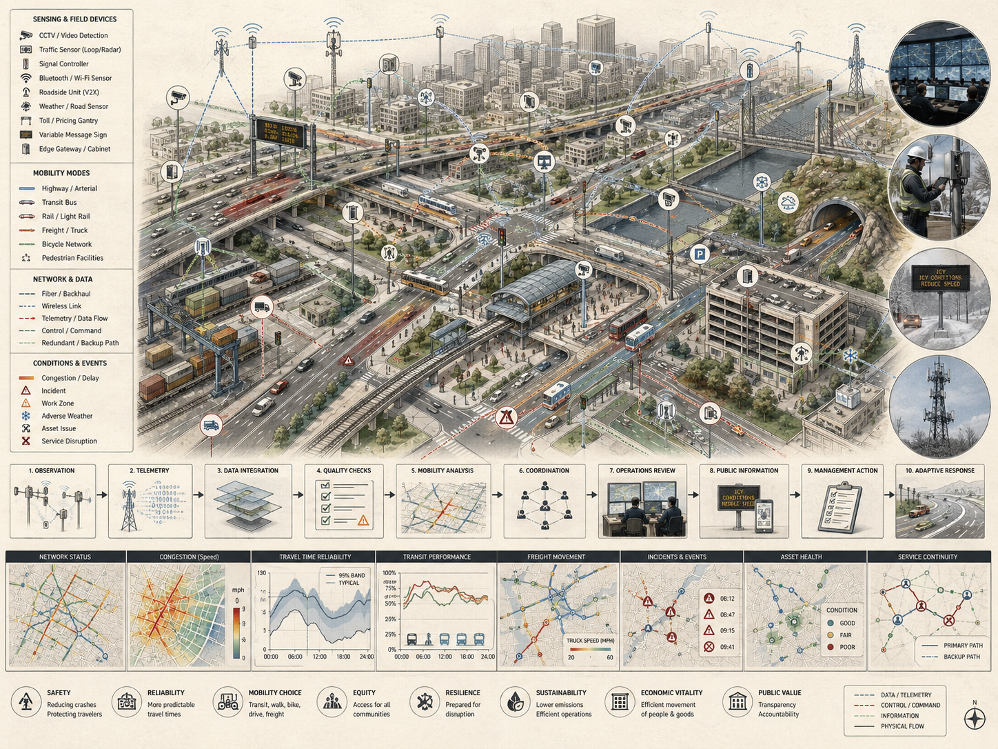
Core Architecture of Intelligent Transportation Networks
Intelligent transportation networks can be understood through a layered architecture that links physical movement systems to digital coordination and institutional response. Each layer matters because weaknesses in infrastructure, sensing, data quality, operations, cybersecurity, or governance can undermine the full mobility system.
Physical Transport Infrastructure Layer
This layer includes roads, rail lines, stations, depots, terminals, sidewalks, cycling facilities, ports, intersections, bridges, tunnels, curb zones, and logistics corridors. These remain the material foundation of mobility and freight circulation. Intelligent transportation cannot compensate for every physical deficiency: poor sidewalks, inaccessible stations, unreliable track, inadequate bus priority, unsafe intersections, and poorly maintained roads all constrain what digital coordination can accomplish.
Sensing and Connectivity Layer
This layer includes loop detectors, cameras, GNSS signals, connected vehicle inputs, roadside units, smart-ticketing devices, fleet telematics, signal controllers, curb sensors, passenger-counting systems, and the communications networks that move transport data across the system. Without this layer, network conditions remain only partially visible. With it, agencies can detect congestion, incidents, service gaps, crowding, loading conflicts, signal failures, and emerging disruption more quickly.
Data and Platform Layer
At this layer, heterogeneous mobility data is collected, aligned, stored, and made available for operational or strategic use. It may include journey-planning platforms, traffic-control systems, fare and ticketing platforms, geospatial systems, freight-visibility tools, curb-management systems, and open-data interfaces. Without interoperability and governance, even data-rich networks remain institutionally fragmented.
Analytical and Operations Layer
This layer includes forecasting, optimization, dispatch, incident management, route planning, transit control, adaptive signal systems, traveler information, freight coordination, and operations-center workflows. It is where transport data begins to shape actual network performance. Analytical systems should document objectives, assumptions, model limits, false-positive risk, and human-review requirements.
Governance and Institutional Layer
This layer includes transport authorities, municipalities, regulators, operators, standards bodies, police and emergency services, accessibility authorities, public-health agencies, and the rules, skills, procurement systems, and accountability structures through which transport systems are governed. It is this layer that determines whether network intelligence improves public mobility or merely produces more operational complexity.
| Layer | Core Capability | Maturity Question |
|---|---|---|
| Physical transport infrastructure | Roads, rail, bus corridors, sidewalks, cycling routes, stations, depots, terminals, curb zones, bridges, and signals | Can the physical network support safe and inclusive multimodal movement? |
| Sensing and connectivity | Traffic detectors, fleet telemetry, connected signals, ticketing systems, curb sensors, vehicle data, communications networks | Can the transport system observe changing conditions reliably and securely? |
| Data and platform systems | Mobility data stores, APIs, geospatial systems, open data, scheduling systems, fare platforms, control systems | Can data be integrated across modes, agencies, operators, and use cases? |
| Analytics and operations | Forecasting, dispatch, signal coordination, incident response, service management, traveler information, logistics coordination | Can mobility signals be translated into meaningful operational action? |
| Governance and public value | Standards, procurement, privacy, cybersecurity, equity, accessibility, public reporting, interagency coordination | Can intelligent transportation serve public goals, rights, and accountability? |
Together these layers show that intelligent transportation is neither purely physical nor purely digital. It is a socio-technical mobility architecture in which infrastructure, information, operations, and institutions must function together.
Multimodal Mobility, Freight, and Network Integration
Intelligent transportation networks span multiple modes, and their value often lies in coordination across those modes rather than digitization within any one of them alone. Roads, buses, rail, sidewalks, bicycle networks, freight systems, curb zones, parking, micromobility, paratransit, taxis, ride-hailing, emergency routes, and public information systems all interact in shared space.
Public Transit and Shared Mobility
Transit intelligence may include real-time vehicle tracking, headway management, digital ticketing, multimodal trip planning, transfer coordination, service alerts, bus priority, rail operations, and first-mile or last-mile integration. These systems improve mobility most when they strengthen the public-transport backbone rather than displacing it. A network can be digitally sophisticated and still underperform if transfers are poor, schedules are unreliable, fare systems are fragmented, stations are inaccessible, or buses remain trapped in congestion.
Road Traffic and Intersections
Adaptive signal control, incident detection, corridor management, lane-use systems, dynamic messaging, traffic information tools, and connected intersections can improve throughput, safety, and travel-time reliability. But these interventions matter most when linked to larger mobility goals such as road safety, bus priority, emissions reduction, emergency access, and equitable street use rather than simply maximizing vehicle flow.
Freight and Logistics
Freight intelligence includes terminal coordination, fleet telematics, route optimization, port and corridor visibility, delivery scheduling, loading-zone management, and digitally coordinated logistics. In many cities and regions, freight remains under-integrated in smart-mobility narratives even though goods movement is essential to economic function and to curb, road, and network management. A network that manages commuters well but ignores deliveries, servicing, and logistics remains only partially intelligent.
Active Mobility and Public Space
Walking and cycling infrastructure also belong within intelligent transportation when cities use data and coordination tools to improve safety, accessibility, route continuity, signal timing, lighting, maintenance, and street design. Transport intelligence is weakened when active modes remain invisible in network planning or are treated as residual afterthoughts rather than core components of urban mobility.
| Mode or Function | Coordination Need | Public-Value Test |
|---|---|---|
| Public transit | Headway management, bus priority, transfer coordination, fare integration, real-time information | Does intelligence improve reliable access for transit-dependent users? |
| Road traffic | Adaptive signals, incident response, corridor management, emergency access, safety monitoring | Does vehicle management improve safety and mobility rather than only throughput? |
| Freight and logistics | Terminal visibility, route coordination, delivery scheduling, curb access, freight corridors | Does logistics intelligence reduce conflict and improve goods movement without shifting burden? |
| Walking and cycling | Safe crossings, route continuity, signal priority, lighting, maintenance, accessibility | Are active modes treated as core mobility systems rather than residual users? |
| Curb and public space | Loading, parking, micromobility, deliveries, accessible pickup, transit stops, pedestrian space | Does curb intelligence manage scarce public space transparently and fairly? |
The key point is that intelligent transportation networks become more useful when they support multimodal coordination and system-wide visibility rather than isolated operational improvements within a single transport mode.
Traffic Management, Transit Operations, and Real-Time Coordination
One of the defining functions of intelligent transportation is operational coordination in real time. Traffic management centers, transit control rooms, incident-response systems, freight platforms, curb-management systems, and fleet platforms all aim to reduce the gap between network conditions and institutional response. This may involve rerouting around incidents, adapting signal timing, prioritizing buses, dispatching recovery crews, adjusting service intervals, managing loading zones, issuing traveler alerts, or communicating delays to the public.
Real-time coordination matters because transport conditions change quickly. A static network can perform poorly under variable demand, weather, construction, breakdowns, crowding, power disruption, or emergency events. Intelligent operations improve the network’s ability to absorb shocks and maintain service quality under changing conditions. But they also increase dependence on data quality, communications reliability, clear authority, and institutional readiness to interpret signals and act decisively.
Operational intelligence therefore cannot be reduced to automated control. It depends equally on human operators, governance rules, emergency protocols, inter-agency communication, accessibility requirements, and the clarity of public information systems. The capacity to act on time-sensitive information is as important as the capacity to collect it.
| Function | Operational Role | Risk If Weak |
|---|---|---|
| Incident detection and response | Identifies crashes, breakdowns, signal failures, flooding, blocked corridors, or disruptions. | Delays propagate through the network before agencies respond. |
| Adaptive signal coordination | Adjusts timing, priority, and flow in response to changing conditions. | Signals improve vehicle flow while harming buses, walking, cycling, or emergency access. |
| Transit operations control | Manages headways, dispatch, crowding, transfers, alerts, and service recovery. | Transit reliability weakens despite digital information. |
| Freight and curb coordination | Manages delivery zones, loading access, port or terminal flows, and logistics conflicts. | Freight operations create congestion, unsafe curb conditions, or neighborhood burden. |
| Traveler information | Communicates disruptions, service changes, route choices, transfer options, and accessibility information. | Users receive data but not usable guidance. |
Real-time coordination becomes publicly valuable when it supports safer and more reliable mobility for the whole network, not only faster movement through selected corridors.
Data, Platforms, and Transportation Observability
Transportation intelligence depends on observability: the ability to know what is happening across the network with enough clarity to act. Intelligent transportation networks increase observability by converting vehicle movements, passenger flows, service delays, signal states, freight patterns, curb use, infrastructure condition, safety events, and incident data into measurable signals. But observability is not just about volume. It depends on whether transport data is reliable, interoperable, contextualized, and connected to operational or policy decisions.
Platforms matter because transport data is usually scattered across agencies, modes, vendors, and operators. A city may have public-transit data, traffic data, logistics data, parking data, curb data, ticketing data, and service-request data, but without integration these streams remain partial and difficult to use collectively. Data only becomes infrastructurally valuable when it supports better planning, regulation, operations, maintenance, and service coordination.
At the same time, mobility data raises questions of privacy, commercial power, interoperability, procurement, vendor lock-in, and control over the public right of way. Standards and mobility-data protocols can improve coordination, but they also require governance that preserves accountability and public purpose. A transport network can become more visible to institutions while becoming less transparent to the public if governance is weak.
| Data Stage | Function | Governance Value |
|---|---|---|
| Raw mobility signal | Records a vehicle, person, signal, incident, transaction, route, or infrastructure event. | Provides the basic observation unit. |
| Quality-controlled record | Applies missingness checks, timestamp validation, location validation, sensor status, and provenance. | Improves trust and interpretability. |
| Mode-linked and asset-linked record | Connects data to roads, routes, stops, stations, signals, corridors, curb zones, or terminals. | Turns mobility data into infrastructure context. |
| Indicator or alert | Summarizes reliability, speed, delay, safety, crowding, access, emissions, or disruption. | Supports operations, public reporting, planning, and regulation. |
| Institutional action | Connects evidence to signal timing, dispatch, maintenance, enforcement, public information, or investment. | Turns transportation observability into public value. |
Transportation data infrastructure should therefore be evaluated by the strength of the observation-action chain, not simply by the scale of data collection.
Safety, Accessibility, and Public Value
Transport networks should not be judged only by speed or throughput. Safety, accessibility, and public value are central to whether transport intelligence is socially meaningful. A faster network that is unsafe for pedestrians, inaccessible to disabled users, weak for low-income commuters, unreliable for transit riders, or burdensome for neighborhoods is not a high-performing public mobility system.
Accessibility matters because transport infrastructure structures access to employment, education, health care, food, public services, recreation, and civic life. Intelligent transportation networks can improve this by making services more legible, reducing uncertainty for travelers, improving interchange quality, supporting more reliable multimodal journeys, and allowing agencies to see where access is weak. But they can also reproduce exclusion if digital interfaces, payment systems, enforcement tools, or data-driven planning are designed without regard to affordability, disability access, language, cash access, device access, or unequal digital literacy.
Public value therefore depends on institutional design as much as technical sophistication. A transport authority may acquire excellent operational tools yet fail to improve mobility equity, road safety, or network accessibility if governance priorities remain narrow. Intelligent transport becomes publicly meaningful when it improves real mobility conditions rather than merely producing more data about them.
| Public-Value Question | Transportation Intelligence Requirement | Failure Mode |
|---|---|---|
| Who is safer? | Track crash risk, near misses, vulnerable users, safe crossings, speed, lighting, and street design. | Efficiency gains increase risk for pedestrians, cyclists, disabled users, or transit riders. |
| Who gains access? | Measure access to jobs, schools, health care, essential services, and transfers by mode and population. | Average travel time improves while access remains unequal. |
| Who can use digital systems? | Design fare, ticketing, routing, and information systems for affordability, language, disability access, and non-smartphone users. | Digital mobility excludes users who most depend on public transport. |
| Who bears the burden? | Evaluate emissions, noise, freight routes, curb conflicts, enforcement, and traffic diversion by neighborhood. | Network optimization shifts harm onto less powerful communities. |
| Who can understand decisions? | Explain objectives, performance metrics, assumptions, trade-offs, and public reporting. | Mobility governance becomes opaque and difficult to contest. |
Transport intelligence should therefore be evaluated by whether it expands safe and reliable access to the city, not only by whether it increases operational precision.
Risk, Cybersecurity, and System Vulnerability
Intelligent transportation networks create new capabilities, but they also create new vulnerabilities. As traffic systems, transit operations, ticketing platforms, connected vehicles, logistics systems, passenger-information services, and operations centers become more digitally mediated, failures in communications networks, cybersecurity controls, cloud services, vendor platforms, or data governance can affect mobility and safety simultaneously. A signaling failure can become a transit reliability failure. A digital ticketing outage can become an access problem. A platform failure can disrupt multiple operators at once.
Risk also comes from concentration and dependence. Transport agencies may become reliant on proprietary systems, outsourced data environments, or poorly interoperable vendors that reduce flexibility and increase lock-in. A region may integrate many functions through a common platform and improve day-to-day coordination, yet also increase the consequences of a major outage or cyber incident. The more transport functions depend on shared digital layers, the more those layers become critical infrastructure in their own right.
For that reason, intelligent transportation networks must be designed with resilience, fallback modes, interoperability, segmentation, manual procedures, and institutional redundancy in mind. A transport system does not become more resilient simply because it is more connected. It becomes more resilient when digital and physical systems can continue supporting safe and accessible mobility under stress, disruption, and partial failure.
| Risk Category | Failure Mode | Mitigation Requirement |
|---|---|---|
| Sensor and telemetry failure | Mobility conditions are delayed, missing, inaccurate, or misinterpreted. | Data-quality flags, redundancy, validation, maintenance, and fallback procedures |
| Platform outage | Traffic control, ticketing, traveler information, dispatch, or logistics systems become unavailable. | Failover architecture, manual operating mode, continuity plan |
| Cybersecurity incident | Signals, ticketing, operations, connected systems, or APIs are manipulated or disrupted. | Authentication, encryption, segmentation, monitoring, incident response |
| Vendor lock-in | Authorities lose control over data, standards, portability, procurement, or long-term maintenance. | Open standards, data portability, contract governance, documentation |
| Algorithmic or operational bias | Optimization favors visible or high-value users while harming vulnerable users or underserved areas. | Equity review, public metrics, model cards, governance oversight |
| Over-automation | Human operators lose situational awareness or control under unusual conditions. | Human-in-the-loop design, drills, escalation rules, operator training |
Intelligent transportation networks should therefore be designed as resilient public infrastructure, not merely as connected mobility platforms.
Governance, Standards, and Institutional Capacity
Governance is central to intelligent transportation because mobility networks are shared, regulated, and politically consequential. Streets, rights of way, transit systems, freight corridors, signal systems, parking, curb management, enforcement, fare systems, and public information environments involve multiple agencies and multiple publics. Intelligent transportation systems therefore depend on standards, procurement capability, institutional coordination, operator competence, and regulatory clarity as much as they depend on devices or software.
Standards matter because transport intelligence increasingly depends on interoperable data flows, communication protocols, and common frameworks for evaluating performance. Without standards, network coordination becomes harder, vendor dependence deepens, and public authorities struggle to compare systems or scale operations across jurisdictions.
Institutional capacity matters just as much. A city or region can procure sophisticated transport technologies yet fail to improve mobility if agencies cannot coordinate, if governance is fragmented across jurisdictions, if transit operators and road authorities remain siloed, if freight is omitted from mobility planning, or if public values are not embedded in design and deployment. Intelligent transportation networks are therefore not only technical systems. They are institutional systems whose quality depends on rules, skills, coordination, finance, public accountability, and long-term maintenance.
| Capability | Purpose | Evidence Artifact |
|---|---|---|
| Public mobility objective setting | Defines whether systems prioritize safety, accessibility, reliability, emissions, freight, resilience, or other public outcomes. | Mobility objective manifest, performance policy, public-value statement |
| Interagency coordination | Links road authorities, transit agencies, freight operators, emergency services, planning departments, and public works. | Coordination charter, operations protocol, shared incident playbook |
| Standards and interoperability | Enables data sharing, comparability, portability, and vendor accountability. | API documentation, data schema, procurement standards, data catalog |
| Rights, privacy, and access governance | Protects mobility data, payment data, location data, enforcement systems, and user rights. | Privacy review, access-control policy, retention policy, transparency report |
| Cybersecurity and continuity | Protects transport systems and ensures safe fallback during outages or attacks. | Security architecture, incident response plan, manual operations plan |
| Public accountability | Explains trade-offs, performance metrics, service impacts, and decision authority. | Public dashboard, evidence package, community feedback record |
The governance question is whether transportation intelligence strengthens public mobility capability and accountability, or whether it simply produces more digital complexity.
Measurement, Indicators, and Transport Performance
Measurement matters because transport systems need ways to assess whether intelligent-network interventions are actually improving mobility conditions. Indicators may include travel-time reliability, crash reduction, transit punctuality, headway regularity, dwell times, accessibility, mode integration, emissions impacts, freight efficiency, curb turnover, incident clearance, service responsiveness, and recovery time. But transport performance cannot be reduced to whatever is easiest to count. A network may improve average speeds while worsening accessibility, safety, affordability, or public space.
This is why broader indicator frameworks matter. Intelligent transportation should be evaluated in terms of service quality, inclusion, safety, sustainability, resilience, and system performance rather than through narrow technological or throughput metrics alone. The most useful indicators are those that help authorities reason about trade-offs rather than conceal them.
Indicators are most valuable when they improve learning, prioritization, and accountability rather than merely feeding dashboards. Transport intelligence is strongest when it supports public reasoning about mobility trade-offs instead of obscuring those trade-offs behind technical jargon or proprietary analytics.
| Metric Type | Example Measure | Interpretive Caution |
|---|---|---|
| Reliability | Travel-time variability, on-time performance, headway regularity, incident recovery time | Average speed can improve while reliability remains poor for users. |
| Accessibility | Jobs, schools, health care, and services reachable by mode within time thresholds | Citywide accessibility can hide neighborhood, disability, fare, or schedule barriers. |
| Safety | Crashes, serious injuries, near-miss indicators, speed exposure, crossing risk | Throughput metrics can obscure harm to vulnerable road users. |
| Transit quality | Wait time, crowding, transfer quality, missed trips, service gaps, bus priority performance | Real-time information does not compensate for unreliable or inadequate service. |
| Freight and curb performance | Loading reliability, dwell time, delivery conflict, freight corridor delay, curb turnover | Freight efficiency can shift burden to neighborhoods or public space. |
| Environmental performance | Emissions, energy use, mode shift, idling, exposure, congestion-related pollution | Efficiency gains can be offset by induced demand or unequal exposure. |
| Governance and data quality | Metadata completeness, uptime, latency, interoperability, privacy review, public reporting | Dashboards can appear authoritative even when underlying data are incomplete. |
Good transportation measurement evaluates the full mobility system: reliability, safety, accessibility, environmental impact, resilience, and public governance together.
Deployment Readiness Gate
Before intelligent transportation workflows are used for traffic operations, transit planning, signal priority, fare systems, traveler information, freight coordination, curb management, safety analysis, public reporting, or emergency response, they should pass a readiness gate. The purpose is not to delay useful transport innovation. It is to confirm that mobility outputs are supported by documented objectives, reliable data, secure systems, interoperability, accessibility review, public governance, and response pathways.
| Readiness Check | Pass Condition | Evidence |
|---|---|---|
| Mobility purpose | Modes, corridors, users, performance goals, public values, and decision pathways are defined. | Mobility objective manifest, performance policy |
| Network and asset inventory | Corridors, routes, stops, signals, curb zones, terminals, stations, and operators are documented. | Transport network inventory, GIS layer, asset register |
| Data quality and telemetry | Latency, missingness, sensor health, timestamp quality, location validity, and provenance are tracked. | Telemetry log, quality-control schema, metadata dictionary |
| Interoperability | Mobility data are linked through shared identifiers, APIs, standards, and common schemas. | Data catalog, API documentation, schema registry |
| Safety and accessibility review | Impacts on vulnerable users, disabled users, transit riders, pedestrians, cyclists, and low-income users are assessed. | Safety review, accessibility review, equity analysis |
| Cybersecurity and continuity | Authentication, segmentation, incident response, failover, manual fallback, and platform continuity are defined. | Security architecture, continuity plan, incident response playbook |
| Operational response | Alerts, indicators, and model outputs are connected to dispatch, signal operations, maintenance, public information, or planning action. | Operations protocol, work-order integration, public communication procedure |
| Public accountability | Performance metrics, assumptions, caveats, governance authority, and review cycles are documented. | Public evidence package, governance log, transparency report |
A transport-intelligence system that cannot pass this readiness gate may still collect useful data, but its outputs should be treated cautiously when used for operational automation, public claims, or infrastructure investment decisions.
Data and Configuration Artifacts
The companion repository can use a data-first structure so intelligent transportation claims can be examined rather than merely asserted. Each artifact has a specific role in making the mobility coordination chain reconstructable across infrastructure, data, service performance, accessibility, safety, freight, governance, and response.
| Artifact | File | Purpose |
|---|---|---|
| Mobility objective manifest | config/mobility_objective.yml |
Defines modes, corridors, decision uses, public values, valid-use limits, and performance priorities. |
| Transport network inventory | data/transport_network_inventory.csv |
Documents routes, corridors, stops, stations, signals, intersections, curb zones, terminals, and operators. |
| Mobility telemetry sample | data/mobility_telemetry_sample.csv |
Stores timestamped traffic, transit, freight, signal, incident, curb, and service-status readings. |
| Service performance review | data/service_performance_review.csv |
Tracks reliability, headway, delay, crowding, recovery time, accessibility, and mode coordination. |
| Multimodal coordination graph | data/multimodal_coordination_edges.csv |
Stores dependencies among roads, transit, freight, curb, walking, cycling, emergency access, and public space. |
| Safety and accessibility review | data/safety_accessibility_review.csv |
Assesses crash exposure, vulnerable users, service access, disability access, and equity gaps. |
| Governance and operations log | data/transport_governance_operations_log.csv |
Documents decisions, incidents, public communication, signal changes, service recovery, and review actions. |
| SQL schema | sql/schema.sql |
Creates a local SQLite database for transportation observability records. |
These artifacts are designed to make transportation intelligence auditable. They can be replaced with institutional data sources later, but the scaffold makes the logic of mobility coordination, public value, and operational review explicit from the beginning.
Mathematical Lens: Mobility Reliability, Accessibility, and Network Coordination
A lightweight mathematical lens helps distinguish mobility intelligence from technology deployment. The point is not to reduce transportation performance to a single score, but to make visible the relationships among reliability, accessibility, safety, coordination, emissions, and governance capacity.
R_m = 1 – \frac{\sigma(T_m)}{\mu(T_m)}
\]
Interpretation: Reliability for mode \(m\) declines as travel-time variability grows relative to average travel time. This is especially important for transit riders, workers, freight operators, and people making time-sensitive trips.
A_o = \sum_{d=1}^{n} O_d \cdot f(T_{o,d})
\]
Interpretation: Accessibility from origin \(o\) depends on the opportunities reachable across the network and the travel burden required to reach them. Intelligent transportation should improve access, not only movement speed.
C_{\mathrm{coord}} =
w_1I +
w_2H +
w_3P +
w_4X +
w_5G
\]
Interpretation: Coordination quality depends on interoperability \(I\), headway or schedule alignment \(H\), priority management \(P\), cross-mode transfer quality \(X\), and governance capacity \(G\).
Q_{\mathrm{mobility}} =
\alpha R +
\beta A +
\gamma S +
\delta C_{\mathrm{coord}} –
\eta E
\]
Interpretation: Mobility quality rises with reliability, accessibility, safety, and coordination, while emissions and environmental burden reduce overall performance.
This mathematical framing should be used as a structured diagnostic, not as a substitute for transport planning, public engagement, engineering review, accessibility analysis, safety assessment, or governance judgment.
Python Workflow: Intelligent Transportation Network Review
The Python workflow in the companion repository can read transport network inventories, mobility telemetry, service performance records, multimodal coordination edges, safety and accessibility reviews, and governance logs; compute reliability scores, coordination scores, recovery lag, accessibility gaps, and operational review flags; and export a governance-ready watchlist. The sample below illustrates the core logic.
from pathlib import Path
import pandas as pd

ARTICLE_DIR = Path("articles/intelligent-transportation-networks-mobility-data-and-network-coordination")
DATA_DIR = ARTICLE_DIR / "data"
OUTPUT_DIR = ARTICLE_DIR / "outputs"
OUTPUT_DIR.mkdir(parents=True, exist_ok=True)

inventory = pd.read_csv(DATA_DIR / "transport_network_inventory.csv")
telemetry = pd.read_csv(DATA_DIR / "mobility_telemetry_sample.csv", parse_dates=["timestamp"])
performance = pd.read_csv(DATA_DIR / "service_performance_review.csv")
coordination = pd.read_csv(DATA_DIR / "multimodal_coordination_edges.csv")
safety_access = pd.read_csv(DATA_DIR / "safety_accessibility_review.csv")

review = (
    telemetry
    .merge(inventory, on="network_element_id", how="left")
    .merge(performance, on="network_element_id", how="left")
    .merge(safety_access, on="service_zone_id", how="left")
)

review["travel_time_reliability"] = (
    1 - (review["travel_time_std_minutes"] / review["travel_time_mean_minutes"])
).clip(lower=0, upper=1)

review["incident_recovery_lag_minutes"] = (
    review["expected_recovery_minutes"] - review["target_recovery_minutes"]
).clip(lower=0)

review["mobility_quality_score"] = (
    0.25 * review["travel_time_reliability"] +
    0.20 * review["accessibility_score"] +
    0.20 * review["safety_score"] +
    0.20 * review["coordination_score"] -
    0.15 * review["emissions_burden_score"]
).clip(lower=0, upper=1)

review["transport_review_flag"] = (
    (review["travel_time_reliability"] < 0.70) |
    (review["accessibility_gap_score"] >= 0.35) |
    (review["safety_risk_score"] >= 0.35) |
    (review["incident_recovery_lag_minutes"] > 0) |
    (review["coordination_score"] < 0.65)
)

watchlist = (
    review[review["transport_review_flag"]]
    .sort_values(
        ["safety_risk_score", "accessibility_gap_score", "incident_recovery_lag_minutes"],
        ascending=[False, False, False]
    )
)

review.to_csv(OUTPUT_DIR / "intelligent_transportation_network_review.csv", index=False)
watchlist.to_csv(OUTPUT_DIR / "transportation_governance_watchlist.csv", index=False)

print(watchlist[[
    "network_element_id",
    "network_element_name",
    "mode",
    "service_zone_id",
    "travel_time_reliability",
    "accessibility_gap_score",
    "safety_risk_score",
    "coordination_score",
    "incident_recovery_lag_minutes"
]])
This workflow is intentionally transparent. It allows analysts to see whether transportation concern arises from reliability, accessibility gaps, safety risk, recovery lag, weak coordination, or emissions burden.
R Workflow: Mobility, Reliability, and Accessibility Reporting
The R workflow can summarize intelligent transportation performance by mode, service zone, corridor, or network element; identify reliability and accessibility gaps; and create stewardship-oriented reports for transport authorities, mobility planners, public works teams, and governance review processes.
library(readr)
library(dplyr)

article_dir <- "articles/intelligent-transportation-networks-mobility-data-and-network-coordination"
data_dir <- file.path(article_dir, "data")
output_dir <- file.path(article_dir, "outputs")
dir.create(output_dir, recursive = TRUE, showWarnings = FALSE)

inventory <- read_csv(file.path(data_dir, "transport_network_inventory.csv"), show_col_types = FALSE)
telemetry <- read_csv(file.path(data_dir, "mobility_telemetry_sample.csv"), show_col_types = FALSE)
performance <- read_csv(file.path(data_dir, "service_performance_review.csv"), show_col_types = FALSE)
safety_access <- read_csv(file.path(data_dir, "safety_accessibility_review.csv"), show_col_types = FALSE)

review <- telemetry %>%
  left_join(inventory, by = "network_element_id") %>%
  left_join(performance, by = "network_element_id") %>%
  left_join(safety_access, by = "service_zone_id") %>%
  mutate(
    travel_time_reliability = pmax(0, pmin(1, 1 - travel_time_std_minutes / travel_time_mean_minutes)),
    incident_recovery_lag_minutes = pmax(expected_recovery_minutes - target_recovery_minutes, 0),
    mobility_quality_score = pmax(
      0,
      pmin(
        1,
        0.25 * travel_time_reliability +
        0.20 * accessibility_score +
        0.20 * safety_score +
        0.20 * coordination_score -
        0.15 * emissions_burden_score
      )
    ),
    transport_review_flag =
      travel_time_reliability < 0.70 |
      accessibility_gap_score >= 0.35 |
      safety_risk_score >= 0.35 |
      incident_recovery_lag_minutes > 0 |
      coordination_score < 0.65
  )

mode_summary <- review %>%
  group_by(mode) %>%
  summarise(
    network_elements = n_distinct(network_element_id),
    mean_reliability = mean(travel_time_reliability, na.rm = TRUE),
    mean_accessibility_gap = mean(accessibility_gap_score, na.rm = TRUE),
    mean_safety_risk = mean(safety_risk_score, na.rm = TRUE),
    mean_coordination = mean(coordination_score, na.rm = TRUE),
    mean_mobility_quality = mean(mobility_quality_score, na.rm = TRUE),
    review_flags = sum(transport_review_flag, na.rm = TRUE),
    .groups = "drop"
  ) %>%
  arrange(desc(review_flags), desc(mean_safety_risk))

write_csv(review, file.path(output_dir, "intelligent_transportation_review_report.csv"))
write_csv(mode_summary, file.path(output_dir, "transportation_mode_summary.csv"))

print(mode_summary)
The purpose is not to produce a definitive transportation rating. It is to demonstrate how reliability, accessibility, safety, coordination, recovery, and environmental burden can be made reproducible and auditable.
Systems Code: Mobility Monitoring, Edge Sensing, and Transportation Coordination
The companion repository can extend the article into a reproducible systems scaffold. Python and R support analytical review; SQL stores evidence; YAML files define objectives and policies; GeoJSON provides spatial placeholders; TypeScript can support dashboard interfaces; Go can support mobility-status APIs; Rust can support strict transport-record validation; C can support reliability and coordination calculations; Fortran can support numerical mobility routines; MicroPython can support low-power traffic, curb, or transit telemetry nodes; PYNQ and HDL can support hardware-assisted stream validation where appropriate.
| Directory | Role | Example Use |
|---|---|---|
python/ |
Reliability scoring, accessibility review, coordination analysis, governance watchlists | Compute transport review flags and mobility quality scores |
r/ |
Mode summaries, corridor reports, service-zone performance review | Summarize reliability, safety, accessibility, and coordination by mode |
sql/ |
Evidence tables and auditable queries | Join network inventory, telemetry, service performance, safety, accessibility, and governance records |
c/ and embedded_c/ |
Low-level mobility-status and telemetry-quality checks | Validate speed, headway, latency, or threshold flags at the edge |
rust/ |
Strict validation and CLI scaffolding | Validate mobility records, reliability scores, and coordination fields |
go/ |
Mobility-status API scaffold | Expose corridor, route, or service-zone status over a lightweight endpoint |
fortran/ |
Numerical reliability and network-performance calculations | Prototype reliability, accessibility, and recovery calculations |
micropython/ |
Edge sensing-node scaffold | Prototype low-power traffic, curb, or transit telemetry nodes |
pynq/ and hdl/ |
Hardware-assisted stream validation | Prototype FPGA checks for speed, latency, headway, or threshold flags |
typescript/ |
Dashboard/interface scaffold | Display mobility quality, reliability, safety risk, accessibility gaps, and recovery lag |
The code should be understood as an engineering scaffold for reproducible intelligent transportation workflows, not as a replacement for certified transport operations, safety engineering, public authority, cybersecurity review, accessibility compliance, or transport planning judgment.
GitHub Repository
The companion repository can house the reproducible data, code, schemas, validation tools, and systems-engineering examples that support this article’s intelligent transportation framework.
Testing and Validation
Testing intelligent transportation networks requires more than checking whether sensors transmit data or dashboards load. Validation should examine whether mobility data are reliable, whether modes are integrated, whether safety and accessibility are protected, whether operational changes improve public outcomes, whether digital systems are secure, and whether fallback procedures function under disruption.
| Validation Area | Test Question | Failure Signal |
|---|---|---|
| Network inventory | Are routes, corridors, signals, stops, stations, curb zones, freight facilities, and responsible agencies documented? | Mobility data cannot be linked to operational context. |
| Telemetry quality | Are timestamps, locations, latency, missingness, sensor status, and provenance tracked? | Dashboards appear current while data are delayed, partial, or invalid. |
| Multimodal integration | Are roads, transit, freight, walking, cycling, curb use, and emergency access evaluated together? | Mode-specific optimization creates cross-system harm. |
| Safety and accessibility | Do interventions improve safe and inclusive mobility for vulnerable users? | Efficiency improves while safety, access, or equity deteriorates. |
| Operational response | Are alerts connected to dispatch, signal changes, service recovery, maintenance, or public information? | Transport systems observe problems but do not act effectively. |
| Cybersecurity and resilience | Are control systems, APIs, ticketing, signals, communications, and platforms protected with fallback modes? | Digital dependency creates operational fragility. |
| Public accountability | Are assumptions, metrics, objectives, trade-offs, and decision authority documented? | Mobility decisions become opaque or difficult to contest. |
Validation should be repeated after platform migrations, signal-policy changes, new fare systems, service redesigns, major incidents, cybersecurity findings, route changes, accessibility complaints, and transportation-plan updates.
Operational Signals and Transportation Network Observability
Transportation network observability means being able to see whether the mobility system and its monitoring systems are functioning as trustworthy public infrastructure. This includes speeds, travel-time variability, headways, missed trips, signal states, incidents, crowding, curb occupancy, freight bottlenecks, crash risk, accessibility gaps, platform health, data latency, telemetry missingness, cybersecurity events, and response closure.
| Signal | What It Reveals | Operational Use |
|---|---|---|
| Travel-time reliability | Whether users can depend on consistent mobility outcomes | Corridor management, transit planning, freight coordination, public reporting |
| Transit headway and dwell time | Whether service is reliable and transfers are feasible | Dispatch, bus priority, station management, schedule adjustment |
| Signal and intersection status | Whether control systems are functioning and supporting priority rules | Traffic operations, pedestrian safety, bus priority, emergency access |
| Incident and recovery lag | Whether disruptions are detected and cleared within target timeframes | Incident management, emergency response, resilience review |
| Curb and freight pressure | Whether loading, deliveries, parking, and public space are in conflict | Curb management, enforcement, freight planning, public-space design |
| Accessibility gap | Whether service improvements reach people and places with limited access | Equity review, service planning, investment prioritization |
| Cyber and platform health | Whether digital transport systems are secure, available, and resilient | Continuity planning, incident response, operations assurance |
Transportation observability is strongest when the system can monitor not only movement, but also reliability, accessibility, safety, resilience, public impact, and the health of the digital systems that support mobility operations.
Engineer and Researcher Checklist
- Define the mobility goals, modes, corridors, users, service zones, public values, and decision pathways the system must support.
- Document routes, roads, rail lines, bus corridors, stops, stations, signals, intersections, curb zones, terminals, depots, and responsible operators.
- Track mobility telemetry quality: timestamps, latency, missingness, location validity, sensor status, platform uptime, and provenance.
- Evaluate reliability, accessibility, safety, emissions, freight performance, curb use, and service recovery rather than throughput alone.
- Link transport records across modes through shared identifiers, interoperable schemas, APIs, metadata, and data catalogs.
- Assess public-transit priority, transfer quality, first-mile and last-mile access, disability access, fare access, and digital inclusion.
- Protect signals, ticketing, control systems, APIs, traveler information, and mobility platforms through cybersecurity architecture and fallback procedures.
- Connect alerts and indicators to dispatch, maintenance, traffic operations, transit control, public information, freight coordination, or capital planning.
- Publish public evidence explaining metrics, assumptions, trade-offs, privacy safeguards, governance authority, and review cycles.
- Use incidents, service disruptions, accessibility complaints, and after-action reviews to revise network design and operations.
This checklist is intentionally practical. It keeps intelligent transportation focused on public mobility, safety, accessibility, resilience, and accountability rather than mobility technology alone.
Where This Fits in the Series
Intelligent transportation networks connect several major threads within the Intelligent Infrastructure Systems knowledge series. They rely on digital infrastructure to move data, cyber-physical systems to connect software and physical mobility assets, urban sensor networks to observe conditions, infrastructure data platforms to integrate records, energy infrastructure to support electrified mobility, environmental monitoring to track emissions and exposure, security systems to protect operations, and governance systems to turn mobility intelligence into accountable public action.
This article therefore functions as a bridge between transportation planning and intelligent infrastructure governance. It shows that intelligent infrastructure is not only about automation, sensing, optimization, or digital platforms. It is also about whether transport systems can improve access, preserve safety, coordinate movement, reduce unequal burden, and adapt under stress.
Future Directions
The future of intelligent transportation networks will likely involve deeper multimodal integration, better freight visibility, stronger public-transit coordination, richer use of AI-enabled analytics, more advanced connected-vehicle and automated-driving communications standards, wider use of mobility data in infrastructure planning, stronger cybersecurity, and more sophisticated public reporting. But the deeper challenge is not simply making transport more connected. It is making transport networks more governable, safer, more accessible, more resilient, and more publicly accountable through infrastructure intelligence.
Intelligent transportation will matter most where it improves real mobility conditions rather than merely digitizing legacy inefficiencies. The long-run goal is not smart mobility as a label. It is a transportation infrastructure system that can see more clearly, coordinate more effectively, respond more safely, and serve more people under changing conditions.
Future work should therefore move beyond mobility technology toward governed transportation intelligence: interoperable, secure, inclusive, accessible, resilient, evidence-based, and accountable to the people and communities whose lives depend on the mobility network.
Related Articles
- Digital Infrastructure Systems
- Cyber-Physical Infrastructure Systems
- Urban Sensor Networks and Infrastructure Monitoring
- Infrastructure Monitoring and Sensor Integration
- Infrastructure Data Platforms and Analytics
- Smart City Infrastructure Systems
- Infrastructure Systems for Urban Resilience
- Monitoring Energy Infrastructure Performance
- Infrastructure Security and Cyber Resilience
- Infrastructure Governance and Policy Systems
These connections are substantive rather than decorative. Intelligent transportation networks are not an isolated mobility-tech category, but a systems domain connecting movement, data, governance, resilience, safety, accessibility, and public infrastructure.
Further Reading
- International Telecommunication Union (ITU) (n.d.) Intelligent Transportation Systems and Smart Mobility in support of the SDGs. Available at: https://www.itu.int/en/ITU-T/ITS/Pages/SDG.aspx.
- International Telecommunication Union (ITU) (n.d.) Intelligent Transport Systems and Smart Mobility. Available at: https://www.itu.int/en/ITU-T/ITS/Pages/default.aspx.
- International Transport Forum (ITF) (n.d.) Mobility Innovation Hub. Available at: https://www.itf-oecd.org/mobility-innovation-hub.
- International Transport Forum (ITF) (2025) AI for Transport Authorities: Principles and Practical Guidance. Available at: https://www.itf-oecd.org/ai-transport-authorities.
- World Bank (n.d.) Transport. Available at: https://www.worldbank.org/ext/en/topic/transport.
- World Bank (2025) Transforming Transportation 2025: From Vision to Action. Available at: https://blogs.worldbank.org/en/transport/transforming-transportation-2025.
- World Bank (2024) Promoting Livable Cities by Investing in Urban Mobility. Available at: https://www.worldbank.org/en/results/2024/03/13/promoting-livable-cities-by-investing-in-urban-mobility.
- United Nations Human Settlements Programme (UN-Habitat) (n.d.) People-Centred Smart Cities. Available at: https://unhabitat.org/programme/people-centred-smart-cities.
References
- International Telecommunication Union (ITU) (n.d.) Intelligent Transportation Systems and Smart Mobility in support of the SDGs. Available at: https://www.itu.int/en/ITU-T/ITS/Pages/SDG.aspx.
- International Telecommunication Union (ITU) (n.d.) Intelligent Transport Systems and Smart Mobility. Available at: https://www.itu.int/en/ITU-T/ITS/Pages/default.aspx.
- International Telecommunication Union (ITU) (2025) Standards shaping the future of connected, automated and safe mobility. Available at: https://www.itu.int/hub/2025/03/standards-shaping-the-future-of-connected-automated-and-safe-mobility/.
- International Telecommunication Union (ITU) (n.d.) Security for Intelligent Transport Systems. Available at: https://www.itu.int/en/ITU-T/ITS/standardization/Pages/sg17.aspx.
- International Transport Forum (ITF) (n.d.) Mobility Innovation Hub. Available at: https://www.itf-oecd.org/mobility-innovation-hub.
- International Transport Forum (ITF) (2025) AI for Transport Authorities: Principles and Practical Guidance. Paris: ITF/OECD. Available at: https://www.itf-oecd.org/sites/default/files/docs/ai-transport-authorities.pdf.
- United Nations Human Settlements Programme (UN-Habitat) (n.d.) The People-Centred Smart Cities Flagship Programme. Available at: https://unhabitat.org/programme/people-centred-smart-cities.
- World Bank (n.d.) Transport. Available at: https://www.worldbank.org/ext/en/topic/transport.
- World Bank (2024) Promoting Livable Cities by Investing in Urban Mobility. Available at: https://www.worldbank.org/en/results/2024/03/13/promoting-livable-cities-by-investing-in-urban-mobility.
- World Bank (2025) Transforming Transportation 2025: From Vision to Action. Available at: https://blogs.worldbank.org/en/transport/transforming-transportation-2025.