
Last Updated May 14, 2026
Weather sensing and atmospheric data systems are latency-sensitive socio-technical infrastructures used to measure fast-changing atmospheric conditions, reconstruct the most plausible current state of the atmosphere, and support forecasting, warning, and real-time decision-making under conditions of uncertainty. They combine surface instruments, upper-air observations, radar, satellite remote sensing, aircraft and marine reports, communication networks, quality-control systems, and data assimilation frameworks in order to transform incomplete and unevenly distributed observations into operational atmospheric knowledge. Weather sensing is therefore not simply the collection of meteorological data. It is the organized production of atmospheric legibility at forecast speed.
Weather is an unusually demanding object of observation because the atmosphere is dynamic, multi-scalar, and only partially visible from any single platform. Temperature, pressure, humidity, wind, clouds, precipitation, visibility, radiation, and vertical structure evolve across minutes to days through interacting processes that span local boundary layers, mesoscale circulations, synoptic systems, and planetary-scale flows. No instrument directly observes “the atmosphere” as a complete state. Instead, weather services infer that state from distributed, heterogeneous, and temporally staggered measurements. Operational weather knowledge is therefore assembled, not simply received.
Modern weather sensing systems support public forecasting, aviation operations, storm warning, hydrometeorological services, marine safety, agricultural planning, energy management, emergency response, infrastructure operations, and climate-sensitive public services. Their deeper significance lies in the fact that they make atmospheric conditions actionable within narrow decision windows. Forecasting, nowcasting, and hazard communication all depend on the speed, quality, interoperability, and structure of the observational system beneath them. In this sense, weather sensing is not merely a technical precondition for meteorology. It is one of the core infrastructures through which societies govern atmospheric uncertainty.
Main Library
Publications
Article Map
Environmental Monitoring
Related Topic
Data Systems
Related Topic
Risk & Resilience
Related Topic
Intelligent Infrastructure
Weather sensing is where environmental monitoring becomes operational atmospheric intelligence. It asks not only whether atmospheric variables can be measured, but whether observations can be transmitted, quality-controlled, standardized, assimilated, and interpreted quickly enough to support forecast, nowcast, warning, and decision workflows. The central question is not simply whether weather data exist. It is whether the observing system can transform partial, fast-changing atmospheric evidence into timely and trustworthy situational awareness.
Engineering Problem
The engineering problem is how to design weather sensing and atmospheric data systems that can transform partial, heterogeneous, rapidly changing observations into a usable estimate of current atmospheric state. Weather systems operate under strict latency constraints. Observations that arrive too late, lack metadata, fail quality control, cannot be standardized, or cannot enter analysis and assimilation workflows may contribute little to operational forecasting even if the instruments themselves are accurate.
This problem is difficult because the atmosphere is both spatially continuous and observationally discontinuous. Surface stations sample local boundary-layer conditions. Radiosondes provide vertical profiles but only at selected places and times. Radar sees precipitation structure and storm motion but not the full thermodynamic environment. Satellites provide broad coverage but often through indirect retrievals. Aircraft reports enrich major corridors while leaving other airspace sparse. Marine buoys and ship reports reduce oceanic gaps but remain logistically limited. Weather knowledge emerges by coordinating these partial views, not by relying on any one platform.
Weak weather sensing treats observation as a data-volume problem. Strong weather sensing treats observation as a real-time state-estimation problem. It asks whether measurements are timely, georeferenced, quality-controlled, standardized, interoperable, vertically informative, spatially representative, assimilable, and linked to forecast or warning decisions. The decisive question is not simply how many observations exist. It is whether the observing system can reconstruct the atmosphere quickly and credibly enough for operational use.
| Engineering Tension | Why It Matters | Required Evidence |
|---|---|---|
| Accuracy versus latency | A precise observation may lose operational value if it arrives after forecast or warning decision windows. | Timestamp, transmission latency, update interval, decision-window requirement |
| Local observation versus atmospheric state | Point measurements do not directly describe the full three-dimensional atmosphere. | Spatial metadata, platform type, vertical profile data, assimilation context |
| Platform diversity versus interoperability | Surface, radar, satellite, aircraft, marine, and upper-air data have different formats, errors, and meanings. | Common schema, metadata standard, platform registry, quality-control rules |
| Surface density versus vertical constraint | Dense surface networks cannot substitute fully for upper-air structure needed for stability, shear, and model initialization. | Upper-air registry, profile coverage, radiosonde/profiler availability, vertical uncertainty note |
| Observation count versus representativeness | Large data volume can still leave oceans, mountains, boundary-layer transitions, or convective environments under-observed. | Coverage audit, blind-spot map, platform gap analysis |
| Quality control versus speed | Operational systems must detect errors quickly without delaying useful data beyond decision relevance. | Automated QC flags, manual review queue, latency budget, provisional-use rules |
| Observation intake versus assimilation readiness | Data in a database are not necessarily usable in model initialization or nowcasting systems. | Assimilation eligibility flag, bias correction, error model, provenance metadata |
The practical question is therefore: can the system transform distributed atmospheric observations into forecast-ready knowledge before the atmosphere has already changed enough to make that knowledge stale?
Reference Architecture
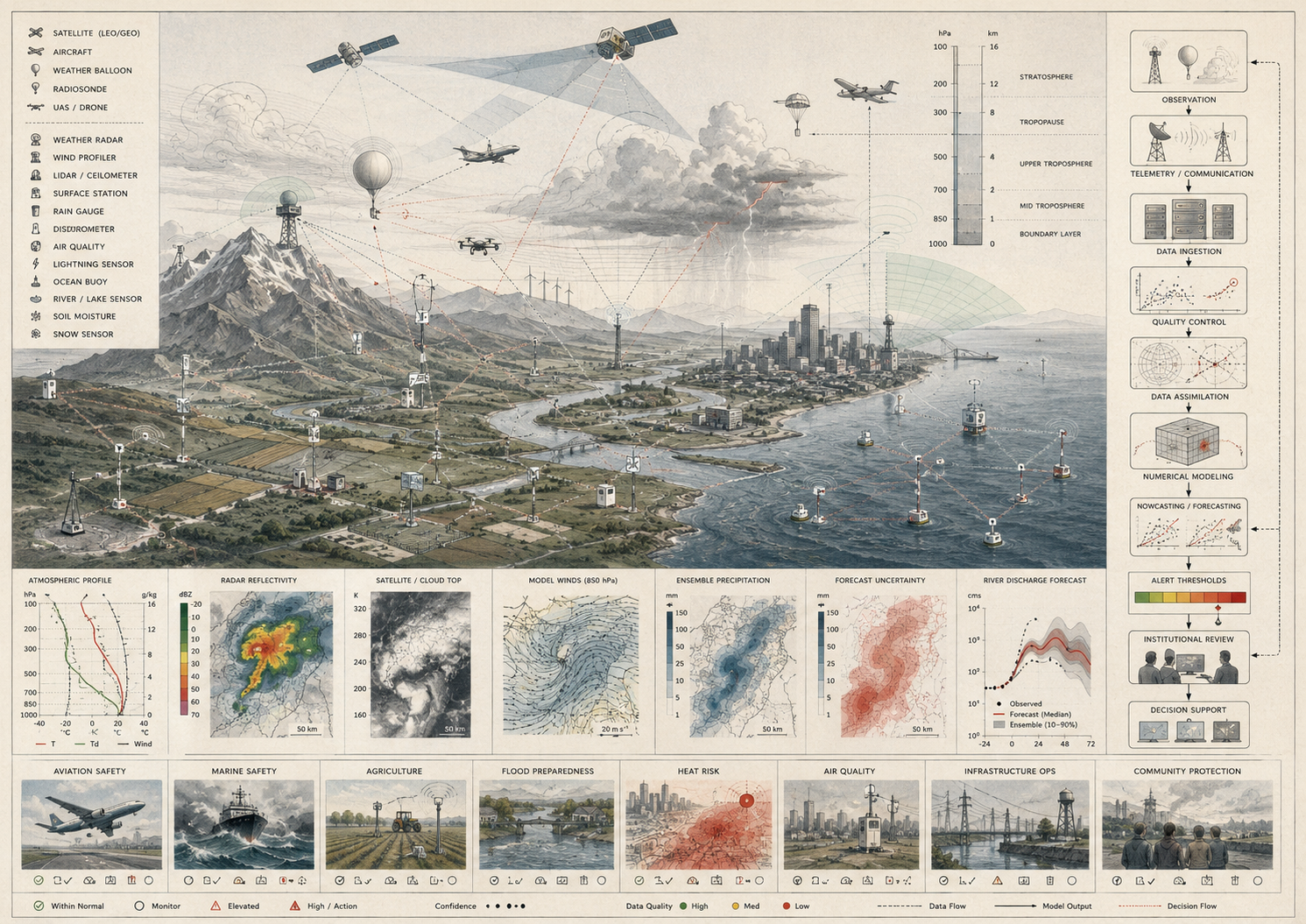
A practical weather sensing architecture can be understood as a real-time atmospheric evidence system. The exact implementation may include surface weather stations, automated airport observing systems, radar networks, radiosondes, wind profilers, satellite retrievals, aircraft reports, ship and buoy observations, lightning networks, telemetry systems, observation coding standards, quality-control pipelines, data assimilation systems, nowcasting platforms, numerical weather prediction interfaces, and forecast decision-support tools. The responsibilities remain consistent: observe, encode, transmit, validate, standardize, integrate, assimilate, forecast, warn, document, and learn.
| Layer | Engineering Role | Primary Risk | Evidence Artifact |
|---|---|---|---|
| Operational objective layer | Defines forecast, nowcast, warning, aviation, marine, hydrological, or decision-support use case and latency requirement. | Observation systems are designed around instruments rather than decisions. | Weather sensing objective manifest, latency budget, decision-use statement |
| Observation platform layer | Registers surface, radar, satellite, upper-air, aircraft, marine, lightning, and specialty observing platforms. | Platform capabilities, limits, ownership, and update frequencies are unclear. | Platform registry, station metadata, sensor inventory |
| Acquisition and telemetry layer | Captures observations, timestamps, geolocation, units, platform metadata, and transmission status. | Data arrive stale, incomplete, or without usable provenance. | Telemetry log, latency report, observation ingest table |
| Quality-control layer | Screens for outliers, sensor failure, siting issues, temporal inconsistency, spatial inconsistency, and coding errors. | Faulty observations distort analysis or forecasts. | QC policy, automated flags, manual-review log, exclusion rules |
| Standardization and interoperability layer | Normalizes variables, units, codes, timestamps, platform identifiers, and metadata for operational exchange. | Observations cannot be combined or reused across systems. | Common schema, data dictionary, exchange-format rules |
| Integration and assimilation layer | Aligns observations with model background fields, error assumptions, bias corrections, and analysis workflows. | Data are collected but not converted into forecast-ready atmospheric state. | Assimilation readiness table, bias-correction record, model-card notes |
| Forecast and nowcast layer | Uses observations and assimilated state estimates for short-range forecasts, nowcasts, hazard tracking, and warnings. | Forecast systems fail to expose uncertainty, freshness, or observational limits. | Forecast product registry, nowcast log, uncertainty statement |
| Governance and learning layer | Reviews network performance, blind spots, data-sharing, maintenance, observational inequality, and corrective action. | Observation gaps persist while forecasts appear authoritative. | Coverage audit, governance log, after-action review, revision record |
This architecture makes clear that weather sensing is not only instrumentation. It is the management of a time-sensitive evidence chain from atmospheric condition to operational atmospheric state.
Implementation Pattern
A rigorous weather sensing implementation begins with the operational decision horizon. Aviation visibility monitoring, severe-storm nowcasting, river-flood forecasting, marine weather services, public daily forecasting, road-weather management, energy-load forecasting, and heat-health alerting do not require identical observation architectures. Each purpose implies different variables, platforms, latency budgets, spatial densities, quality-control rules, assimilation requirements, and communication pathways.
| Artifact | Purpose | Suggested Format |
|---|---|---|
| Weather sensing objective manifest | Defines use case, geography, variables, platforms, latency budget, decision horizon, and forecast workflow. | YAML, Markdown, architecture decision record |
| Observation platform registry | Stores platform ID, type, owner, location, variables, update frequency, siting, and operational status. | CSV, SQL table, GeoJSON |
| Atmospheric observation records | Stores variable values, units, timestamps, geolocation, platform type, QC flags, and freshness metadata. | CSV, Parquet, SQL table, time-series database |
| Telemetry and latency log | Tracks expected observations, received observations, transmission time, latency, outages, and stale records. | CSV, observability export, time-series health table |
| Quality-control policy | Documents range checks, internal consistency checks, spatial buddy checks, temporal checks, and manual review rules. | YAML, Markdown, SQL rule table |
| Assimilation readiness table | Identifies which observations are eligible for model initialization, nowcasting, bias correction, or decision support. | CSV, SQL table, model-ingest manifest |
| Coverage and blind-spot audit | Identifies sparse regions, vertical gaps, marine gaps, radar limitations, and lower-capacity network areas. | CSV, GIS layer, audit memo |
| Forecast-use and warning log | Tracks how observations supported forecasts, nowcasts, warnings, or operational decisions. | CSV, SQL table, incident log |
| Governance and data-sharing log | Tracks network ownership, standards, cross-agency exchange, quality caveats, maintenance, and revision history. | CSV, Markdown, SQL table |
The implementation goal is to make atmospheric knowledge reconstructable. A user should be able to move from a forecast, warning, nowcast, or operational decision back to the observations, platform metadata, latency, QC flags, assimilation rules, uncertainty notes, and governance records that supported it.
Research-Grade Framing: Weather Observation as Real-Time Epistemic Infrastructure
A research-grade account of weather sensing begins by treating it as real-time epistemic infrastructure rather than as meteorological data collection. Weather observing systems organize how the present atmosphere becomes knowable under severe time constraints. Unlike long-duration climate record systems, which prioritize continuity and comparability over decades, weather observation prioritizes speed, interoperability, update frequency, rapid quality control, and integration into forecast and warning workflows. The problem is not only to measure the atmosphere, but to know it quickly enough for the knowledge to matter.
This requires recognizing that operational atmospheric knowledge is inferential. Surface stations observe local conditions. Radiosondes reveal vertical profiles at specific times and places. Radar captures precipitation structure and motion, but not the totality of thermodynamic state. Satellites provide broad spatial coverage, but often through indirect measurement and retrieval. Aircraft and marine observations add critical detail, yet remain uneven in distribution. Weather sensing systems therefore work by assembling partial, platform-specific glimpses into a coherent operational estimate of atmospheric state.
For this reason, the epistemic problem of weather observation is not solved at the sensor alone. It is solved through the coordination of instruments, standards, communication systems, data screening, spatial-temporal alignment, and assimilation frameworks that make heterogeneous observations jointly interpretable. In operational meteorology, the atmosphere is not fully observed in any simple sense. It is reconstructed from evidence.
| Limited Pattern | Stronger Pattern | Why the Shift Matters |
|---|---|---|
| Collect weather measurements | Design a real-time evidence chain for state estimation, forecasting, nowcasting, and warnings | Prevents data volume from being mistaken for atmospheric intelligence. |
| Track surface variables | Integrate surface, upper-air, radar, satellite, aircraft, marine, and model-background evidence | Captures the atmosphere as a three-dimensional, multi-platform inference problem. |
| Move data into storage | Move data into time-sensitive QC, interoperability, assimilation, and decision workflows | Distinguishes archived data from operational knowledge. |
| Report station status | Report observation freshness, latency, platform health, QC status, and assimilation eligibility | Protects forecast workflows from stale or untrustworthy evidence. |
| Assume broad coverage equals adequacy | Audit vertical gaps, ocean gaps, radar gaps, sparse regions, and lower-capacity observation areas | Makes observational inequality and forecast uncertainty visible. |
| Treat model forecasts as separate from observations | Document how observations constrain model initialization, nowcasts, and forecast correction | Clarifies the dependence of prediction on observed initial conditions. |
The central research question is not “How many weather observations are available?” but “What kind of atmospheric state estimate can the system produce, how quickly, with what uncertainty, and for what operational decision?”
Formal Model: Observation, Latency, Coverage, Assimilation, and Atmospheric Evidence Quality
A useful formal model separates observation freshness, platform coverage, vertical constraint, quality-control validity, assimilation readiness, spatial representativeness, uncertainty communication, and governance readiness. Let \(O_i\) represent an observation, \(T_o\) observation time, \(T_a\) arrival time, \(L_o\) observation latency, \(C_s\) spatial coverage, \(C_v\) vertical coverage, \(Q_c\) quality-control completeness, \(A_r\) assimilation readiness, \(U_c\) uncertainty communication, and \(G_r\) governance readiness. Weather-sensing evidence quality depends on these dimensions together, not on isolated observations alone.
L_o = T_a – T_o
\]
Interpretation: Observation latency is the time between measurement and operational availability. Lower latency improves usefulness for nowcasting, forecasting, and warning.
F_{\mathrm{fresh}} = \frac{N_{\mathrm{fresh}}}{N_{\mathrm{expected}}}
\]
Interpretation: Observation freshness measures the share of expected observations that arrive within the operational latency budget.
C_{\mathrm{platform}} =
\frac{P_{\mathrm{active}}}{P_{\mathrm{required}}}
\]
Interpretation: Platform coverage estimates the fraction of required observation platforms that are active and reporting.
A_{\mathrm{ready}} =
\frac{N_{\mathrm{assimilable}}}{N_{\mathrm{valid}}}
\]
Interpretation: Assimilation readiness measures the share of valid observations that meet metadata, format, freshness, and quality requirements for model or nowcast ingestion.
Q_{\mathrm{weather\ evidence}} =
w_1F_{\mathrm{fresh}} +
w_2C_s +
w_3C_v +
w_4Q_c +
w_5A_r +
w_6R_p +
w_7U_c +
w_8G_r
\]
Interpretation: Weather evidence quality depends on freshness, spatial coverage, vertical coverage, quality-control completeness, assimilation readiness, representativeness, uncertainty communication, and governance readiness.
This formal structure protects against a common mistake in weather sensing: treating raw observation volume as if it directly represented operational atmospheric knowledge. Weather evidence becomes stronger when observation freshness, platform coverage, vertical constraint, QC, assimilation readiness, uncertainty, and governance are evaluated together.
What Are Weather Sensing and Atmospheric Data Systems?
Weather sensing and atmospheric data systems are integrated systems for measuring the present atmosphere and translating those measurements into operationally usable data products. They include field instruments, observing platforms, telemetry networks, coding standards, quality-control procedures, data exchange systems, assimilation frameworks, forecasting interfaces, and decision-support workflows that together support rapid interpretation of atmospheric conditions.
These systems often include surface weather stations measuring temperature, pressure, humidity, precipitation, wind, and related near-surface variables; upper-air systems such as radiosondes and profiling instruments that reveal vertical atmospheric structure; weather radar systems that detect precipitation structure, storm organization, and mesoscale evolution; satellite platforms that provide broad cloud, moisture, thermal, and atmospheric-motion information; aircraft, airport, ship, buoy, and marine observations that extend coverage across key corridors and sparse regions; and operational data systems that move observations into analysis, nowcasting, and forecast workflows. WMO’s Guide to Instruments and Methods of Observation provides detailed standards for measuring meteorological variables, while WMO’s global observing and information systems support international observation exchange. NOAA’s ASOS/AWOS systems provide continuous automated surface observations across more than 900 U.S. sites, and ECMWF’s operational assimilation workflows process large volumes of satellite and non-satellite observations for forecasting.
The defining feature of weather sensing systems is not simply that they observe the atmosphere, but that they do so within short decision horizons. Their purpose is to support an evolving operational representation of atmospheric conditions that can guide forecasts and warnings on timescales measured in minutes to hours. Weather sensing is therefore best understood as a live observational architecture rather than as a static monitoring network.
| Observation Form | Primary Question | Typical Evidence | Main Risk |
|---|---|---|---|
| Surface weather observation | What are near-surface atmospheric conditions? | Temperature, pressure, humidity, wind, precipitation, visibility, present weather | Local conditions are overgeneralized beyond siting and representativeness limits. |
| Upper-air observation | What is the vertical structure of the atmosphere? | Radiosonde profiles, wind profilers, temperature, humidity, pressure, wind with height | Vertical gaps weaken stability, shear, and model-initialization understanding. |
| Radar observation | Where are precipitation, storms, and mesoscale structures evolving? | Reflectivity, velocity, storm motion, precipitation structure, severe-weather signatures | Radar coverage gaps or beam geometry limits create false confidence. |
| Satellite observation | What large-scale cloud, moisture, temperature, and atmospheric motion patterns are visible? | Imagery, radiances, retrievals, atmospheric motion vectors, cloud and moisture fields | Indirect retrievals are interpreted without uncertainty or assimilation context. |
| Aircraft and aviation observation | What conditions are present along flight corridors and around airports? | Wind, temperature, turbulence, aircraft reports, airport weather observations | Dense corridor observations leave other regions sparse. |
| Marine and ocean observation | What atmospheric and surface conditions are present over oceans and coastal waters? | Buoy, ship, sea-level pressure, wind, waves, marine weather reports | Oceanic data remain sparse despite major influence on weather development. |
Weather sensing systems are therefore more than instrument networks. They are operational infrastructures for making the atmosphere measurable, interoperable, and forecast-relevant in near real time.
Why Weather Sensing Matters
Weather sensing matters because atmospheric conditions change rapidly and because many weather-sensitive decisions are tightly bound to time. Hazardous winds, convective storms, freezing conditions, dense fog, heavy precipitation, heat, winter-weather transitions, aviation hazards, marine hazards, and rapidly shifting boundary-layer conditions can emerge and intensify on timescales that leave little room for observational delay. The value of a weather sensing system is therefore inseparable from timeliness, spatial reach, vertical constraint, and the ability to update atmospheric understanding continuously.
These systems matter scientifically because weather prediction depends on observed initial conditions. They matter operationally because transport, agriculture, water management, energy systems, aviation, marine services, public safety, emergency response, and infrastructure operations all depend on a credible picture of atmospheric conditions. They matter institutionally because public weather services require coordinated observation and fast data exchange to sustain forecasts and warnings. A forecast is never produced from theory alone. It is constrained by the quality and structure of the observational system that feeds it.
Weather sensing also matters because the atmosphere is multi-scalar. Local surface conditions interact with topography, land-surface processes, boundary-layer dynamics, moisture transport, frontal systems, convection, jet streams, and upper-level flow. No single platform resolves these interactions completely. Effective weather observation therefore depends on the integration of multiple observing modes, each of which captures a different aspect of atmospheric behavior.
| Need | Weather-Sensing Contribution | Risk Without Strong Observation |
|---|---|---|
| Forecast initialization | Constrains model starting conditions through surface, upper-air, satellite, radar, aircraft, and marine observations. | Forecast errors grow from weak or biased initial-state estimates. |
| Severe-weather warning | Supports storm detection, tracking, nowcasting, and warning updates. | Hazards evolve faster than the observing system can characterize them. |
| Aviation safety | Provides airport, visibility, wind, ceiling, turbulence, icing, and convective-weather information. | Flight operations face stale or incomplete atmospheric awareness. |
| Hydrometeorological services | Tracks precipitation, storm evolution, snow, and atmospheric drivers of flood risk. | Water and flood forecasts lack timely weather forcing evidence. |
| Energy and infrastructure operations | Supports load forecasting, renewable generation, outage planning, and weather-sensitive asset management. | Infrastructure decisions are made from insufficiently current atmospheric information. |
| Public trust | Improves credibility of forecasts and warnings through timely, verified, and explainable observations. | Forecast uncertainty appears arbitrary or unsupported. |
| Equitable protection | Extends atmospheric visibility to places otherwise under-observed. | Forecast quality and warning lead time vary with observational inequality. |
Weather sensing matters because atmospheric knowledge has a short shelf life. Without timely observation, the atmosphere becomes operationally unknowable at the very moment when public decisions depend on knowing it.
Weather Observation as Real-Time Epistemic Infrastructure
Weather sensing is best understood as a real-time epistemic infrastructure: a system that organizes how the present atmosphere becomes knowable under severe time constraints. Unlike long-duration climate record systems, which prioritize continuity and comparability over decades, weather observation prioritizes speed, interoperability, update frequency, and rapid integration into decision workflows. The problem is not only to measure the atmosphere, but to know it quickly enough for the knowledge to matter.
This knowledge role is inferential. Surface stations observe local conditions. Radiosondes reveal vertical profiles at specific times and places. Radar captures precipitation structure and motion, but not the totality of thermodynamic state. Satellites provide broad spatial coverage, but often through indirect measurement and retrieval. Aircraft and marine observations add critical detail, yet remain uneven in distribution. Weather sensing systems therefore work by assembling partial, platform-specific glimpses into a coherent operational estimate of atmospheric state.
This means that weather observations do not become knowledge automatically. They become knowledge through timing, metadata, standards, quality control, comparison, integration, and assimilation. A weather station reading without site metadata, a radar product without context, a satellite retrieval without uncertainty, or an upper-air profile that arrives late may all be less operationally useful than they appear. Weather sensing is powerful because it turns distributed atmospheric signals into a usable estimate of present conditions. It is risky when partial observations are mistaken for complete atmospheric awareness.
| Observation Choice | What Becomes More Visible | What May Remain Less Visible |
|---|---|---|
| Dense surface networks | Near-surface temperature, wind, pressure, humidity, precipitation, and local variability. | Vertical structure, upper-level flow, oceanic conditions, and remote terrain. |
| Upper-air profiles | Stability, moisture depth, wind shear, vertical temperature structure, and model-initialization constraints. | Rapid spatial variation between launch sites and launch times. |
| Radar systems | Precipitation structure, storm motion, severe-weather signatures, and short-horizon hazard evolution. | Clear-air thermodynamics, low-level gaps, blocked beams, and distant shallow features. |
| Satellite systems | Broad cloud, moisture, atmospheric motion, thermal, and remote-region information. | Direct surface or boundary-layer measurement without retrieval uncertainty. |
| Aircraft observations | High-value data along flight corridors and around aviation-critical regions. | Areas outside major routes or lower-traffic regions. |
| Marine platforms | Oceanic atmospheric conditions, coastal transitions, and marine weather forcing. | Dense global ocean coverage comparable to land networks. |
Atmospheric knowledge is therefore not located in any single instrument. It is produced by the organized interaction of platforms, standards, communication systems, quality controls, and models.
Core Atmospheric Variables and Measurement Targets
Weather sensing systems are organized around variables that describe the current state and near-term evolution of the atmosphere. These variables are important not only because they are individually meaningful, but because their interaction shapes forecast-relevant atmospheric behavior.
| Variable Group | Typical Measurements | Operational Use | Interpretive Caveat |
|---|---|---|---|
| Thermodynamic state | Temperature, dew point, humidity, pressure, virtual temperature | Air-mass analysis, stability, heat stress, fog, precipitation type, model initialization | Surface values do not fully describe vertical structure or local exposure. |
| Wind field | Wind speed, wind direction, gusts, upper winds, shear, low-level jets | Aviation, severe storms, fire weather, marine hazards, transport, energy forecasting | Siting, terrain, height, averaging period, and gust definition matter. |
| Hydrometeors and precipitation | Rain, snow, hail, precipitation intensity, accumulation, type, radar reflectivity | Flood forecasting, winter weather, storm tracking, hydrological forcing | Gauge undercatch, radar beam geometry, bright-band effects, and phase changes complicate interpretation. |
| Cloud and visibility | Cloud cover, ceiling, cloud height, visibility, fog, present weather | Aviation, road safety, solar forecasting, nowcasting, public weather services | Local variation and instrument limitations can produce sharp spatial differences. |
| Vertical atmospheric structure | Profiles of temperature, humidity, pressure, wind, stability, and moisture depth | Convective forecasting, model initialization, storm environment analysis | Profiles are sparse in time and space relative to the atmosphere’s variability. |
| Radiative and surface-state indicators | Solar radiation, longwave radiation, soil temperature, surface temperature, snow cover | Energy, agriculture, boundary-layer analysis, road weather, land-atmosphere exchange | Surface heterogeneity can make point measurements weakly representative. |
| Remote-sensing retrievals | Satellite radiances, cloud-top properties, water vapor, atmospheric motion vectors, radar products | Broad coverage, data-sparse regions, nowcasting, assimilation, storm analysis | Retrievals are indirect and require error characterization. |
These variables do not operate independently. Pressure gradients influence wind. Moisture interacts with temperature and cloud processes. Vertical profiles condition convection and stability. Surface heating alters turbulent exchange and near-surface structure. Weather sensing is therefore not the sum of separate measurements, but the coordinated observation of interacting atmospheric states whose significance emerges through relationship rather than isolation.
Key Analytical Distinctions
Weather sensing is not the same as climate monitoring. Weather systems are optimized for current conditions, rapid updates, and short-range decision support. Climate monitoring systems are optimized for long-term continuity, homogenization, and trend detection across decades. They may share platforms, but their temporal logic and epistemic priorities differ.
Observation is not the same as atmospheric knowledge. A measurement does not become operationally meaningful merely by being recorded. It must be quality-checked, located in time and space, interpreted against neighboring observations and model expectations, and integrated into a broader estimate of atmospheric state.
Observation is not the same as nowcasting. Nowcasting uses observations, often at high temporal frequency, to interpret immediate atmospheric evolution such as storms, rainfall, fog, convective initiation, winter precipitation transitions, or hazardous wind. It depends on observation, but adds pattern recognition, extrapolation, and short-horizon inference.
Observation is not the same as numerical weather prediction. Forecast models estimate future atmospheric states. Observation constrains the initial state and provides continuous correction pressure on model realism, but forecasting remains a separate inferential step.
Data assimilation is not the same as data intake. Assimilation does not merely collect observations into a database. It uses observations and short-range forecasts together to estimate the best plausible atmospheric state and its uncertainties. In other words, it reconstructs a state space, not just a data table.
Coverage is not the same as adequacy. A high volume of observations can still leave crucial gaps if the network undersamples vertical structure, oceans, rapidly developing convection, mountainous terrain, boundary-layer transitions, or regions with sparse institutional capacity. Observational quantity does not automatically guarantee forecast-relevant completeness.
| Distinction | Why It Matters | Design Implication |
|---|---|---|
| Weather sensing versus climate monitoring | Short-range operations and long-term trend detection have different data priorities. | Maintain separate valid-use statements for forecast operations and climate records. |
| Observation versus atmospheric state | Point data do not automatically describe the full atmosphere. | Use integration, analysis, and assimilation workflows. |
| Data intake versus assimilation | Stored observations may not be forecast-ready. | Track assimilation eligibility, metadata completeness, bias correction, and error models. |
| Surface coverage versus vertical coverage | Forecast-relevant structure depends heavily on vertical profiles. | Audit upper-air gaps and profile update frequency. |
| Observation freshness versus archive completeness | Forecast workflows depend on observations arriving within operational windows. | Track latency and freshness, not only data completeness. |
| Platform volume versus representativeness | Many observations can still overrepresent airports, roads, cities, or wealthy regions. | Audit observation geography, platform bias, and under-observed populations. |
These distinctions prevent weather sensing from being reduced to sensor dashboards. The system’s purpose is to produce timely atmospheric evidence that can support forecasts, warnings, and operational decisions.
System Architecture: From Observation to Operational Atmospheric State
Weather sensing and atmospheric data systems operate as layered architectures that transform distributed measurements into forecast-ready atmospheric knowledge. Atmospheric variables are measured by stations, radiosondes, radar, satellites, aircraft, ships, buoys, and automated systems. Signals are digitized, time-stamped, georeferenced, encoded into structured observation formats, and transmitted through operational communication systems into national, regional, and global information networks. Observations are screened for outliers, transmission failures, instrument errors, internal inconsistencies, and spatial-temporal plausibility. Platform-specific measurements are then aligned into analysis-ready observational fields. Data assimilation combines observations with short-range model forecasts to estimate the best current atmospheric state and its uncertainties. The resulting analysis supports numerical prediction, severe-weather operations, nowcasting, aviation guidance, marine services, and hazard communication.
| Stage | Transformation | Failure Risk |
|---|---|---|
| Atmospheric process | Atmospheric variables evolve through local, mesoscale, synoptic, and planetary dynamics. | The selected variables or platforms fail to represent the operational question. |
| Observation | Stations, profiles, radar, satellites, aircraft, and marine platforms capture partial evidence. | Platform gaps, siting problems, or retrieval limits weaken interpretation. |
| Acquisition | Signals are digitized, timestamped, georeferenced, and encoded. | Metadata errors make observations difficult to trust or reuse. |
| Transmission | Data move through operational networks into weather services and data platforms. | Latency, outage, or packet loss reduces operational value. |
| Quality control | Values are screened for range, consistency, spatial plausibility, instrument problems, and coding issues. | Bad data enter forecasts, or good data are wrongly rejected. |
| Integration | Observations are harmonized across variables, units, platforms, and time windows. | Heterogeneous streams remain siloed or incompatible. |
| Assimilation | Observations and model-background fields are combined into a best-estimate atmospheric state. | Data are collected but fail to improve state estimation. |
| Forecast, nowcast, and warning use | Operational systems use the atmospheric state estimate to produce predictions and decisions. | Forecast products hide observation limits, uncertainty, or staleness. |
This architecture reveals a crucial point: the operational meaning of an observation depends on its place in the chain. A precise measurement that arrives too late, lacks metadata, or cannot be assimilated efficiently may contribute less to forecast skill than a less precise but better integrated observation. In weather systems, epistemic value is shaped by timeliness and system fit as much as by instrument accuracy alone.
Platform Ecology and the Logic of Complementary Observation
Modern weather sensing depends on a platform ecology in which each observing mode resolves a different atmospheric problem. The strength of the overall system lies not in redundancy alone, but in complementarity.
Surface weather stations provide local boundary conditions and continuous near-surface measurements. They are indispensable for documenting the atmospheric interface with the built and natural environment, supporting local forecasts, aviation operations, road-weather management, energy forecasting, and routine synoptic analysis.
Upper-air observations resolve vertical structure. They reveal temperature stratification, moisture layering, wind shear, and atmospheric stability — features that are essential for understanding convection, storm environments, frontal structure, and model initialization. Without vertical profiles, the atmosphere remains operationally underdescribed.
Radar systems capture mesoscale precipitation structure, storm organization, and evolving hazard signatures. They are particularly valuable for short-horizon warning operations because they reveal movement and development that point sensors alone cannot infer.
Satellite systems provide synoptic to planetary coverage, especially over oceans, remote land, and other data-sparse regions. They are indispensable for observing cloud systems, moisture fields, atmospheric motion, and large-scale weather organization at scales unattainable from surface networks alone.
Aircraft observations provide dense reporting along operational corridors and contribute both upper-air and near-airport information that can improve forecast accuracy in heavily trafficked regions.
Marine and ocean-based observations reduce one of the most persistent weaknesses in observing systems: the relative scarcity of direct atmospheric measurements over oceans. Since oceanic conditions strongly influence weather development, these platforms are crucial despite their logistical difficulty.
| Platform | Primary Strength | Operational Use | Main Limitation |
|---|---|---|---|
| Surface station | Frequent local near-surface measurement. | Local forecasts, aviation, road weather, climate-sensitive operations. | Local siting and exposure may limit representativeness. |
| Radiosonde / profiler | Vertical atmospheric structure. | Stability, shear, moisture depth, model initialization. | Sparse launch locations and temporal gaps. |
| Weather radar | Precipitation and storm structure in near real time. | Severe weather, precipitation nowcasting, hydrological forcing. | Beam blockage, distance effects, low-level gaps, non-precipitation ambiguity. |
| Satellite | Broad spatial coverage and remote-region visibility. | Clouds, moisture, atmospheric motion, data-sparse regions, assimilation. | Indirect retrievals and vertical-resolution limitations. |
| Aircraft report | Operational corridor and aviation-level atmospheric information. | Upper winds, temperature, turbulence, airport approaches, model input. | Coverage follows flight patterns and commercial traffic. |
| Marine buoy / ship | Oceanic and coastal atmospheric observations. | Marine forecasts, storm development, ocean-atmosphere interaction. | Sparse deployment and harsh maintenance conditions. |
The atmosphere becomes more operationally visible when these platforms are combined because each resolves a different piece of the state-estimation problem. Surface networks capture local conditions; upper-air systems provide vertical constraint; radar tracks evolving weather structure; satellites supply broad coverage; aircraft and marine systems reduce corridor and oceanic gaps. Weather knowledge emerges from their orchestration.
Quality Control, Standardization, and Data Integrity
Operational weather systems depend on trusted data because atmospheric analysis proceeds under time pressure. Quality control and standardization are therefore not bureaucratic supplements; they are constitutive parts of forecast-ready observation. A measurement with unclear timing, faulty siting, poor coding, inconsistent calibration, or unrecognized platform bias can degrade the operational picture faster than it can improve it.
| Practice | Purpose | Evidence Artifact | Failure Risk |
|---|---|---|---|
| Instrument calibration | Ensures sensors produce values consistent with measurement standards. | Calibration log, maintenance record, instrument metadata | Sensor drift appears as atmospheric change. |
| Siting and exposure documentation | Clarifies whether observations represent the intended atmospheric environment. | Station metadata, siting class, exposure notes, photographs | Local bias contaminates wider interpretation. |
| Time synchronization | Ensures observations align with forecast, nowcast, and assimilation cycles. | Timestamp audit, clock-sync status, latency log | Old or misaligned data distort state estimation. |
| Range and consistency checks | Detects impossible or internally inconsistent values. | QC flags, rule table, automated screening output | Erroneous data enter operational products. |
| Spatial buddy checks | Compares observations with nearby stations or model background fields. | Spatial QC report, neighbor comparison, outlier flag | Local anomalies are wrongly accepted or rejected. |
| Platform metadata preservation | Maintains instrument type, height, platform, method, ownership, and update frequency. | Platform registry, observation schema, provenance fields | Observations lose valid-use context. |
| Standardized exchange | Allows observations to flow across agencies, models, services, and archives. | Common schema, encoding format, WMO/agency standard notes | Data remain siloed or incompatible. |
These practices matter because operational systems cannot rely on slow manual correction during hazardous or rapidly evolving events. Forecasting infrastructures depend on standardized observational streams robust enough to be trusted quickly. In this sense, standardization is an epistemic accelerator: it makes fast knowledge possible by reducing ambiguity in what observations mean and how they can be used.
Latency, Blind Spots, and Failure Modes
An exceptional account of weather sensing must include its limits. Weather observing systems are never complete, and their weaknesses shape forecast uncertainty in systematic ways.
Latency is a central issue. Even a high-quality observation loses value if it arrives after critical analysis windows or warning decisions. Operational systems are therefore vulnerable not only to missing data, but to stale data.
Spatial blind spots persist over oceans, remote terrain, sparsely instrumented regions, mountainous areas, polar regions, and lower-capacity institutional environments. Satellite observation reduces some of these gaps, but cannot fully eliminate the need for in situ and upper-air constraint.
Vertical under-observation is especially consequential. The atmosphere’s most important forecast-relevant structures often depend on height, not just horizontal coverage. Without sufficient vertical information, stability, shear, and moisture structure can be inadequately represented.
Platform heterogeneity introduces its own uncertainty. Different sensors, reporting practices, retrieval methods, heights, update intervals, and error characteristics do not combine seamlessly without careful processing and interpretation.
False precision is another risk. Large volumes of data can create an illusion of completeness even when key phenomena remain poorly sampled. Forecast skill depends on the structure and relevance of the observing system, not merely on raw observation counts.
Rapidly evolving convective events present a special challenge because they can outpace observational refresh cycles or emerge in local environments insufficiently sampled by the available network. In such cases, operational atmospheric knowledge remains probabilistic and incomplete even in technologically advanced systems.
| Failure Mode | How It Appears | Why It Matters | Mitigation |
|---|---|---|---|
| Stale observation | Data arrive after the forecast or warning cycle. | Operational value collapses despite measurement quality. | Latency budgets, freshness flags, telemetry monitoring. |
| Surface overconfidence | Dense surface data are treated as enough to describe the atmosphere. | Vertical structure remains weakly constrained. | Upper-air audits, profiler integration, satellite and aircraft assimilation. |
| Radar blind spot | Beam blockage, range effects, or low-level gaps hide important features. | Hazard detection and precipitation estimation are degraded. | Multi-radar mosaics, gap analysis, gauge correction, satellite support. |
| Satellite retrieval overuse | Indirect products are treated as direct observations without uncertainty. | Model and nowcast products may overstate certainty. | Error characterization, validation, assimilation caveats. |
| Platform bias | Observations cluster around airports, roads, cities, shipping lanes, or wealthy regions. | Forecast quality becomes geographically unequal. | Coverage audits, low-cost networks, marine and remote-region investment. |
| QC over-rejection | Extreme but real observations are flagged as erroneous. | Hazard signatures are lost. | Context-aware QC, manual review queue, severe-weather exception logic. |
| QC under-rejection | Faulty readings pass automated checks. | Bad data distort analysis and forecasts. | Spatial consistency checks, station health monitoring, platform diagnostics. |
These limits do not diminish the value of weather sensing; they define the realism with which it must be understood. Forecasting is always conducted under observational imperfection. The strength of the system lies in how well it manages, rather than eliminates, atmospheric uncertainty.
Data Assimilation, Nowcasting, and Forecast Production
Data assimilation is the central bridge between observation and forecasting because it transforms heterogeneous measurements into an estimated atmospheric state suitable for prediction. Its purpose is not simply to gather observations, but to combine them with short-range forecasts in order to determine the best possible present atmospheric state and its uncertainties.
This is where weather sensing becomes operational atmospheric intelligence. Measurements are compared against model expectations, inconsistencies are weighed, and the system updates its estimate of the atmosphere in light of both observation and physics. In this sense, the current atmosphere used in forecasting is neither a raw measured reality nor a purely model-generated abstraction. It is an assimilated reconstruction constrained by both.
Nowcasting occupies a related but distinct role. It uses high-frequency observational updates — especially radar, satellite, lightning, dense surface observations, and short-range model guidance — to interpret immediate atmospheric evolution over the next minutes to hours. Nowcasting is especially important where warning decisions depend less on long forecast lead times than on rapid tracking of already-developing phenomena.
| Workflow | Observation Role | Primary Output | Key Failure Risk |
|---|---|---|---|
| Operational analysis | Combines current observations into a coherent picture of present conditions. | Surface maps, upper-air analyses, mesoscale diagnostics. | Observations are uneven, stale, or poorly quality-controlled. |
| Data assimilation | Combines observations with model-background fields and error assumptions. | Forecast-ready atmospheric state estimate. | Observations lack metadata, bias correction, or error characterization. |
| Nowcasting | Uses high-frequency observations to track immediate hazard evolution. | Minutes-to-hours hazard guidance. | Update frequency or sensor coverage fails to match hazard speed. |
| Numerical weather prediction | Uses assimilated state estimates as initial conditions for future simulation. | Forecast fields, ensembles, probability products. | Initial-state errors grow into forecast errors. |
| Warning decision support | Uses observations, analyses, nowcasts, and forecasts to evaluate hazard thresholds. | Alerts, warnings, advisories, decision-support products. | Warnings hide observational uncertainty or stale evidence. |
Together, assimilation and nowcasting show that operational forecasting is not a one-step leap from sensor to forecast. It is a layered inferential process in which observations are turned into a present-state estimate, and that estimate becomes the basis for both short-horizon interpretation and model-based prediction.
Governance, Coordination, and Observational Inequality
Weather sensing depends on governance because operational forecasting requires coordinated data exchange across platforms, agencies, sectors, and borders. Local measurements become more valuable when they can be integrated into wider observational and forecasting systems. Operational meteorology is therefore inherently cooperative, relying on common standards, telecommunications structures, observational programs, maintenance regimes, and institutional trust.
There is also a geography of observational inequality. Some regions benefit from dense surface networks, rich aviation reporting, strong radar coverage, high-quality telecommunications, frequent upper-air programs, and robust institutional capacity. Others remain weakly observed due to cost, geography, infrastructure limitations, conflict, remoteness, oceanic exposure, or fragile public institutions. This matters because forecast quality and warning lead time are shaped by the observational conditions under which atmospheric state is inferred.
Observational inequality also has ethical consequences. Populations facing severe weather risk may not benefit equally from the same quality of atmospheric visibility. A system that performs well over dense transport corridors and wealthy regions but poorly over oceans, remote terrain, informal settlements, or lower-capacity states is not observationally neutral. Strengthening weather sensing capacity is therefore also a matter of public safety inclusion.
| Governance Responsibility | Question | Evidence |
|---|---|---|
| Standards governance | Are variables, units, methods, metadata, and exchange formats standardized? | Data dictionary, observation schema, WMO/agency standard notes |
| Network governance | Who owns, maintains, funds, and audits each platform? | Platform registry, maintenance log, ownership record |
| Quality governance | How are suspect, missing, stale, extreme, or conflicting observations handled? | QC policy, flag table, manual review log, exclusion rationale |
| Data-sharing governance | Can observations move across agencies, countries, models, and archives? | Data-sharing agreement, exchange protocol, interoperability audit |
| Assimilation governance | Which observations are eligible for model ingest, bias correction, or nowcast use? | Assimilation readiness table, model-ingest manifest, error-model note |
| Equity governance | Which regions, populations, hazard zones, and decision contexts are under-observed? | Coverage audit, blind-spot map, investment-priority record |
| Learning governance | Does the system revise itself after forecast failures, missed hazards, or network outages? | After-action review, corrective-action log, governance record |
Operational weather governance must therefore be understood as more than the maintenance of instruments. It is the maintenance of coordinated atmospheric visibility: the shared ability to observe enough of the atmosphere, quickly enough, and well enough, to support collective protection against weather risk.
Future Directions
The future of weather sensing lies in denser multi-platform observation, faster data pathways, better platform integration, improved quality-control automation, richer satellite and aircraft data, expanded marine observation, and more continuous updating of atmospheric state. Automated surface systems, improved radar networks, expanded profiler capabilities, richer aircraft and marine reporting, and increasingly accessible data platforms are pushing weather observation toward higher frequency and broader reach.
The deeper challenge, however, is not merely scaling volume. It is preserving operational trust under increasing complexity. Future systems must remain interoperable, quality-controlled, latency-aware, and decision-relevant even as observational density grows and platform diversity expands. They must also improve coverage in under-observed regions and reduce the latency that can make even good observations operationally weak.
Artificial intelligence and machine learning will increasingly affect observation processing, quality control, data assimilation, nowcasting, and forecast interpretation. But AI does not eliminate the need for strong observational infrastructure. If anything, it raises the stakes for provenance, bias review, platform metadata, uncertainty communication, and governance. A fast model trained or initialized on uneven observations can reproduce observational inequality at computational speed.
Weather sensing and atmospheric data systems are therefore evolving from traditional meteorological networks into real-time atmospheric knowledge infrastructures. Forecasting skill, warning credibility, and public trust all depend on them. Weather services are only as real as the observing systems beneath them, and the practical governance of atmospheric risk is only as strong as the collective capacity to sense, reconstruct, and communicate the atmosphere at speed.
Deployment Readiness Gate
Before a weather sensing system is used for operational forecasting, severe-weather nowcasting, aviation services, marine guidance, hydrometeorological forecasting, energy operations, infrastructure decision support, or public warning, it should pass a deployment readiness gate. This gate should test whether observations are timely, representative, quality-controlled, standardized, assimilable, uncertainty-aware, and governance-aligned.
| Readiness Area | Required Question | Pass Evidence |
|---|---|---|
| Purpose readiness | Does the system define decision use, geography, variables, platforms, forecast workflow, and latency budget? | Weather sensing objective manifest, decision-use statement, latency target |
| Platform readiness | Are surface, upper-air, radar, satellite, aircraft, marine, and specialty platforms documented? | Platform registry, station metadata, sensor inventory |
| Telemetry readiness | Do observations arrive within the operational time window with complete timestamps and geolocation? | Telemetry log, latency report, freshness flags |
| Quality-control readiness | Are range checks, consistency checks, spatial checks, station-health checks, and review flags defined? | QC policy, automated flag table, manual review process |
| Interoperability readiness | Can observations be exchanged, decoded, interpreted, and reused across systems? | Common schema, data dictionary, exchange format, metadata standard |
| Assimilation readiness | Are observations eligible for model initialization, nowcasting, or forecast correction where needed? | Assimilation readiness table, model-ingest manifest, bias-correction notes |
| Coverage readiness | Are spatial, vertical, marine, radar, satellite, and lower-capacity-region gaps documented? | Coverage audit, blind-spot map, investment-priority list |
| Uncertainty readiness | Are observation limits, platform errors, freshness, retrieval uncertainty, and valid-use caveats exposed? | Uncertainty statement, valid-use notes, forecast evidence package |
| Governance readiness | Are ownership, maintenance, data-sharing, corrective actions, and public accountability documented? | Governance log, maintenance plan, data-sharing agreement, after-action review |
This readiness gate prevents weather sensing from being treated as complete merely because instruments or data feeds exist. The stronger standard is whether the system can produce timely, trusted, interoperable, and forecast-relevant atmospheric knowledge.
Data and Configuration Artifacts
A reproducible weather-sensing workflow should include explicit artifacts for objectives, platforms, observations, telemetry, latency, quality control, coverage, assimilation readiness, forecast use, and governance. These artifacts make atmospheric claims auditable rather than hidden inside data feeds, dashboards, model workflows, or operational routines.
| Artifact | Purpose | Suggested Path |
|---|---|---|
| Weather sensing objective manifest | Defines use case, geography, variables, platforms, forecast workflow, and latency budget. | config/weather_sensing_objective.yml |
| Observation platform registry | Stores platform ID, type, owner, location, variables, height, update frequency, and operational status. | data/observation_platform_registry.csv |
| Atmospheric observation records | Stores weather variables, units, timestamps, geolocation, platform type, and QC flags. | data/atmospheric_observations.csv |
| Telemetry and latency records | Tracks expected reports, received reports, arrival time, latency, outage, and freshness status. | data/telemetry_latency_log.csv |
| Quality-control rules | Documents range checks, internal consistency checks, spatial checks, temporal checks, and manual review rules. | config/quality_control_policy.yml |
| Assimilation readiness records | Identifies observations eligible for model, nowcast, or analysis workflow use. | data/assimilation_readiness_records.csv |
| Coverage and blind-spot audit | Identifies spatial, vertical, marine, radar, satellite, and institutional coverage gaps. | data/coverage_blindspot_audit.csv |
| Forecast-use log | Tracks whether observations supported forecasts, nowcasts, warnings, aviation, marine, or public products. | data/forecast_use_log.csv |
| Readiness and evidence-quality scores | Assesses freshness, coverage, vertical constraint, QC completeness, assimilation readiness, and governance. | data/weather_sensing_readiness_scores.csv |
| Governance and data-sharing log | Tracks ownership, data-sharing, maintenance, standards, quality caveats, and corrective actions. | data/weather_sensing_governance_log.csv |
These artifacts turn weather sensing into a reproducible atmospheric evidence system rather than a loose collection of station feeds, platform products, and forecast-support datasets.
Mathematical Lens: Latency, Coverage, Assimilation Readiness, and Atmospheric Evidence Quality
Several simple metrics can help evaluate weather-sensing readiness. These metrics are not substitutes for meteorological expertise, instrument standards, forecast verification, or operational judgment, but they make atmospheric evidence quality more inspectable.
L_o = T_a – T_o
\]
Interpretation: Observation latency is the time between measurement and operational availability. Lower latency improves usefulness for nowcasting, forecasting, and warning.
F_{\mathrm{fresh}} = \frac{N_{\mathrm{fresh}}}{N_{\mathrm{expected}}}
\]
Interpretation: Observation freshness measures the share of expected observations that arrive within the operational latency budget.
C_{\mathrm{platform}} =
\frac{P_{\mathrm{active}}}{P_{\mathrm{required}}}
\]
Interpretation: Platform coverage estimates the fraction of required observation platforms that are active and reporting.
A_{\mathrm{ready}} =
\frac{N_{\mathrm{assimilable}}}{N_{\mathrm{valid}}}
\]
Interpretation: Assimilation readiness measures the share of valid observations that meet metadata, format, freshness, and quality requirements for model or nowcast ingestion.
Q_{\mathrm{weather\ evidence}} =
w_1F_{\mathrm{fresh}} +
w_2C_s +
w_3C_v +
w_4Q_c +
w_5A_r +
w_6R_p +
w_7U_c +
w_8G_r
\]
Interpretation: Weather evidence quality depends on freshness, spatial coverage, vertical coverage, quality-control completeness, assimilation readiness, representativeness, uncertainty communication, and governance readiness.
These measures evaluate weather sensing as a real-time atmospheric evidence system. They ask whether observations are timely, quality-controlled, representative, interoperable, assimilable, uncertainty-aware, and governance-ready enough to support the operational decision being made.
Python Workflow: Weather Sensing Readiness and Atmospheric Evidence Quality
A Python workflow can demonstrate how weather sensing systems might be evaluated for observation freshness, spatial coverage, vertical coverage, quality-control completeness, assimilation readiness, representativeness, uncertainty communication, and governance readiness. The purpose is not to create a universal atmospheric score, but to make evidence-quality dimensions visible.
from dataclasses import dataclass
from typing import List
import pandas as pd

@dataclass
class WeatherSensingProgram:
    program_id: str
    operational_use: str
    geography: str
    observation_freshness: float
    spatial_coverage: float
    vertical_coverage: float
    qc_completeness: float
    assimilation_readiness: float
    representativeness: float
    uncertainty_communication: float
    governance_readiness: float
    high_stakes_use: bool

def weather_evidence_quality(program: WeatherSensingProgram) -> float:
    return (
        0.15 * program.observation_freshness +
        0.13 * program.spatial_coverage +
        0.13 * program.vertical_coverage +
        0.14 * program.qc_completeness +
        0.14 * program.assimilation_readiness +
        0.11 * program.representativeness +
        0.10 * program.uncertainty_communication +
        0.10 * program.governance_readiness
    )

def classify_review_priority(program: WeatherSensingProgram, score: float) -> str:
    if program.high_stakes_use and program.observation_freshness < 0.75:
        return "high_stakes_latency_review"
    if program.spatial_coverage < 0.70:
        return "spatial_coverage_review"
    if program.vertical_coverage < 0.70:
        return "vertical_coverage_review"
    if program.qc_completeness < 0.75:
        return "quality_control_review"
    if program.assimilation_readiness < 0.75:
        return "assimilation_readiness_review"
    if program.representativeness < 0.70:
        return "representativeness_review"
    if program.uncertainty_communication < 0.75:
        return "uncertainty_communication_review"
    if program.governance_readiness < 0.75:
        return "governance_readiness_review"
    if score < 0.75:
        return "weather_evidence_quality_review"
    return "routine_monitoring"

programs: List[WeatherSensingProgram] = [
    WeatherSensingProgram(
        "surface-weather-network",
        "public_forecast_and_aviation",
        "regional_land_network",
        0.88,
        0.82,
        0.58,
        0.86,
        0.78,
        0.80,
        0.76,
        0.80,
        True,
    ),
    WeatherSensingProgram(
        "upper-air-profile-network",
        "model_initialization_and_convective_forecasting",
        "synoptic_profile_sites",
        0.78,
        0.70,
        0.82,
        0.84,
        0.80,
        0.72,
        0.78,
        0.76,
        True,
    ),
    WeatherSensingProgram(
        "radar-nowcasting-network",
        "severe_weather_nowcasting",
        "convective_risk_region",
        0.86,
        0.76,
        0.64,
        0.82,
        0.74,
        0.70,
        0.76,
        0.78,
        True,
    ),
    WeatherSensingProgram(
        "marine-observation-network",
        "marine_forecast_and_storm_tracking",
        "coastal_and_ocean_region",
        0.72,
        0.62,
        0.52,
        0.76,
        0.68,
        0.64,
        0.72,
        0.74,
        True,
    ),
]

records = []
for program in programs:
    score = weather_evidence_quality(program)
    records.append({
        "program_id": program.program_id,
        "operational_use": program.operational_use,
        "geography": program.geography,
        "observation_freshness": program.observation_freshness,
        "spatial_coverage": program.spatial_coverage,
        "vertical_coverage": program.vertical_coverage,
        "qc_completeness": program.qc_completeness,
        "assimilation_readiness": program.assimilation_readiness,
        "representativeness": program.representativeness,
        "uncertainty_communication": program.uncertainty_communication,
        "governance_readiness": program.governance_readiness,
        "weather_evidence_quality": round(score, 3),
        "review_priority": classify_review_priority(program, score),
    })

df = pd.DataFrame(records)
print(df.sort_values(["review_priority", "weather_evidence_quality"]))
This workflow treats weather sensing programs as atmospheric evidence systems. A program is not ready merely because it has instruments or observations. It must preserve enough evidence about freshness, platform coverage, vertical constraint, QC, assimilation readiness, representativeness, uncertainty, and governance to support the intended operational claim.
R Workflow: Observation Coverage, Latency, and Assimilation Readiness
An R workflow can support weather-sensing governance by summarizing readiness across surface networks, upper-air programs, radar nowcasting systems, satellite feeds, aircraft observations, and marine observations. This is useful for observing-system audits, forecast-support review, public evidence packages, and investment planning.
library(dplyr)
library(readr)

weather_programs <- tribble(
  ~program_id, ~operational_use, ~geography, ~observation_freshness, ~spatial_coverage, ~vertical_coverage, ~qc_completeness, ~assimilation_readiness, ~representativeness, ~uncertainty_communication, ~governance_readiness, ~high_stakes_use,
  "surface-weather-network", "public_forecast_and_aviation", "regional_land_network", 0.88, 0.82, 0.58, 0.86, 0.78, 0.80, 0.76, 0.80, TRUE,
  "upper-air-profile-network", "model_initialization_and_convective_forecasting", "synoptic_profile_sites", 0.78, 0.70, 0.82, 0.84, 0.80, 0.72, 0.78, 0.76, TRUE,
  "radar-nowcasting-network", "severe_weather_nowcasting", "convective_risk_region", 0.86, 0.76, 0.64, 0.82, 0.74, 0.70, 0.76, 0.78, TRUE,
  "marine-observation-network", "marine_forecast_and_storm_tracking", "coastal_and_ocean_region", 0.72, 0.62, 0.52, 0.76, 0.68, 0.64, 0.72, 0.74, TRUE
)

weather_summary <- weather_programs %>%
  mutate(
    weather_evidence_quality = round(
      0.15 * observation_freshness +
      0.13 * spatial_coverage +
      0.13 * vertical_coverage +
      0.14 * qc_completeness +
      0.14 * assimilation_readiness +
      0.11 * representativeness +
      0.10 * uncertainty_communication +
      0.10 * governance_readiness,
      3
    ),
    review_priority = case_when(
      high_stakes_use & observation_freshness < 0.75 ~ "high_stakes_latency_review",
      spatial_coverage < 0.70 ~ "spatial_coverage_review",
      vertical_coverage < 0.70 ~ "vertical_coverage_review",
      qc_completeness < 0.75 ~ "quality_control_review",
      assimilation_readiness < 0.75 ~ "assimilation_readiness_review",
      representativeness < 0.70 ~ "representativeness_review",
      uncertainty_communication < 0.75 ~ "uncertainty_communication_review",
      governance_readiness < 0.75 ~ "governance_readiness_review",
      weather_evidence_quality < 0.75 ~ "weather_evidence_quality_review", TRUE ~ "routine_monitoring" ) ) %>%
  arrange(review_priority, weather_evidence_quality)

print(weather_summary)

write_csv(
  weather_summary,
  "outputs/weather_sensing_readiness_summary.csv"
)
The R workflow emphasizes that weather-sensing review should account for freshness, coverage, vertical constraint, quality control, assimilation readiness, representativeness, uncertainty communication, and governance. These dimensions help prevent atmospheric observing systems from being judged by observation count alone.
Systems Code: Observations, Platforms, Telemetry, QC, Assimilation, and Forecast Logs
Weather sensing depends on full-stack atmospheric data systems. The stack includes platform registries, observation records, telemetry logs, latency checks, quality-control rules, station-health diagnostics, exchange formats, assimilation readiness records, forecast-use logs, coverage audits, blind-spot maps, uncertainty statements, data-sharing interfaces, and governance records. A serious companion repository should therefore include both analytical workflows and systems-code scaffolding.
| Language / Tool | Role in Companion Repository | Example Use |
|---|---|---|
| Python | Weather-sensing readiness scoring, latency review, QC triage, assimilation readiness, and platform audits | Atmospheric evidence-quality scoring and review prioritization |
| R | Observation coverage summaries, latency reporting, forecast-use tables, and governance outputs | Reporting-ready observing-system audit tables |
| SQL | Platform registries, observation records, telemetry logs, QC flags, assimilation records, and governance logs | Auditable atmospheric data-system schema |
| GeoJSON | Station locations, radar domains, upper-air sites, marine platforms, and coverage gaps | Spatial registry for weather-observing systems |
| TypeScript | Dashboard and platform data models | Observation cards, latency panels, platform status, QC and assimilation readiness views |
| Go | Lightweight weather-observation status endpoint | Expose platform, telemetry, QC, and assimilation readiness |
| Rust | Safe validation CLI for observation records and metadata | Validate timestamps, units, platform IDs, variable codes, and QC flags |
| C / C++ | Low-level observation-record and bounded queue examples | Demonstrate embedded station records and operational event buffers |
| Shell scripts | Reproducible directory, validation, and export workflows | One-command scaffold validation and output generation |
This breadth is appropriate because weather sensing is not only meteorological instrumentation. It is evidence infrastructure spanning observation, telemetry, quality control, interoperability, data assimilation, forecasting, warning, and public accountability.
GitHub Repository
A companion repository for this article should translate the weather-sensing framework into reproducible technical scaffolding. The repository should include weather sensing objective manifests, observation platform registries, atmospheric observation records, telemetry and latency logs, quality-control policies, assimilation readiness records, coverage audits, readiness scoring workflows, SQL schemas, dashboard data types, and governance records.
Testing and Validation
Testing weather sensing systems requires more than confirming that observations exist. It requires validating station metadata, platform status, variable definitions, units, timestamps, latency, sensor health, siting, quality-control flags, telemetry completeness, spatial coverage, vertical coverage, assimilation eligibility, forecast-use records, uncertainty statements, and governance workflows. A system can appear observationally rich while producing weak forecast evidence if its observations are stale, biased, under-documented, or operationally unusable.
| Test Type | Purpose | Example Test |
|---|---|---|
| Platform metadata test | Ensure platform type, location, height, owner, variables, update frequency, and status are documented. | Validate observation platform registry fields. |
| Timestamp and latency test | Ensure observations arrive within forecast and warning decision windows. | Compare observation time, arrival time, and latency budget. |
| Variable and unit test | Ensure atmospheric variables and units are standardized across platforms. | Validate variable codes and unit conversions. |
| Quality-control test | Ensure outliers, internal inconsistencies, station failures, and spatial anomalies are flagged. | Run range, temporal, spatial, and station-health checks. |
| Telemetry completeness test | Ensure expected observations are received with acceptable completeness and freshness. | Calculate received versus expected reports by platform and time window. |
| Vertical coverage test | Ensure upper-air constraint is adequate for forecast and severe-weather workflows. | Audit profile coverage, update timing, and key forecast regions. |
| Assimilation readiness test | Ensure observations have the metadata, QC status, freshness, and error assumptions needed for model use. | Review assimilation readiness table and model-ingest manifest. |
| Coverage and blind-spot test | Ensure sparse areas, marine gaps, radar gaps, and lower-capacity regions are identified. | Compare platform registry with geography, hazards, and decision uses. |
| Forecast-use test | Ensure observations are connected to forecast, nowcast, warning, or operational decisions. | Trace forecast-use logs and after-action records. |
| Governance test | Ensure standards, data-sharing, maintenance, uncertainty, and corrective actions are documented. | Review governance log, maintenance records, and public evidence package. |
Validation should test the observing system as a real-time atmospheric evidence chain. The decisive question is not whether an observation was recorded, but whether it was timely, trustworthy, interoperable, and usable for the operational claim being made.
Operational Signals and Weather-Sensing Observability
Weather sensing systems must observe themselves. A system that measures the atmosphere but cannot report platform health, telemetry completeness, observation freshness, latency, QC status, assimilation eligibility, coverage gaps, forecast-use status, and governance caveats is operationally fragile. Monitoring-system observability should track both atmospheric evidence and observing-chain health.
| Signal | Why It Matters | Failure Indicator |
|---|---|---|
| Platform health | Determines whether stations, radar, satellites, profiles, aircraft feeds, and marine platforms are available. | Outage, sensor fault, stale platform metadata, maintenance overdue. |
| Telemetry completeness | Determines whether expected observations are arriving. | Missing reports, delayed feeds, incomplete variables, intermittent transmission. |
| Observation freshness | Determines whether data are still operationally useful. | Observation age exceeds forecast or warning latency budget. |
| QC status | Determines whether values are valid, suspect, provisional, or excluded. | Unflagged outliers, excessive rejection, inconsistent checks. |
| Assimilation eligibility | Determines whether observations can improve model state estimation. | Missing metadata, stale timing, unsupported format, missing error assumptions. |
| Vertical constraint | Determines whether atmospheric structure is sufficiently observed. | Missing profiles, sparse upper-air data, outdated vertical information. |
| Coverage equity | Determines whether atmospheric visibility is geographically and institutionally uneven. | Remote, marine, lower-capacity, or high-risk regions remain under-observed. |
| Forecast-use linkage | Determines whether observations actually support operational products. | Data are collected but not used in forecast, nowcast, or warning workflows. |
| Governance closure | Determines whether failures lead to corrective action. | Outage or forecast-failure reviews lack owner, deadline, or resolution. |
Operational observability protects weather sensing from silent evidence degradation. It helps ensure that the appearance of atmospheric visibility does not outlast the quality and accountability of the observing system beneath it.
Engineer and Researcher Checklist
- Define the operational use case, geography, variables, latency budget, forecast workflow, and decision horizon before evaluating platforms.
- Distinguish weather sensing, climate monitoring, nowcasting, data assimilation, and numerical weather prediction.
- Document platform type, owner, location, instrument height, variables, update frequency, station status, and metadata provenance.
- Track observation time, arrival time, freshness, latency, and whether data arrived within operational decision windows.
- Maintain quality-control policies for range checks, temporal consistency, spatial plausibility, internal consistency, and station health.
- Preserve valid-use caveats for surface observations, upper-air profiles, radar products, satellite retrievals, aircraft reports, and marine data.
- Audit spatial coverage, vertical coverage, radar gaps, marine gaps, remote-region gaps, and lower-capacity observation areas.
- Distinguish data intake from assimilation readiness; document metadata, QC, error models, bias correction, and model-ingest eligibility.
- Use observation freshness and telemetry completeness metrics, not only archived data completeness.
- Document how observations support forecasts, nowcasts, warnings, aviation products, marine services, or public decision support.
- Expose uncertainty, observational blind spots, latency limitations, and platform biases in public evidence packages.
- Use after-action reviews to revise platforms, QC rules, telemetry pathways, data-sharing agreements, and coverage priorities.
Where This Fits in the Series
This article connects Environmental Monitoring Systems to climate monitoring, air quality monitoring, remote sensing, satellite observation, climate early warning, environmental data platforms, risk and resilience, and intelligent infrastructure. It sits at the fast-time atmospheric observation layer of the series: the point where distributed environmental sensing becomes operational weather intelligence.
Within the broader series, this article provides the atmospheric observation framework that supports climate monitoring systems and environmental observation, climate early warning systems, remote sensing systems in environmental monitoring, satellite observation and Earth-system monitoring, environmental data platforms and decision support systems, air quality monitoring systems, environmental sensor networks, IoT architectures for environmental monitoring, edge computing in environmental monitoring, and monitoring environmental risk and resilience. Its role is to show that weather intelligence does not emerge from measurements alone. It emerges from the relationship among platform ecology, latency, quality control, interoperability, data assimilation, uncertainty, and governance.
Related articles
- Environmental Monitoring Systems
- Air Quality Monitoring Systems
- Climate Monitoring Systems and Environmental Observation
- Climate Early Warning Systems
- Environmental Sensor Networks
- Remote Sensing Systems in Environmental Monitoring
- Satellite Observation and Earth System Monitoring
- Environmental Data Platforms and Decision Support Systems
- Monitoring Environmental Risk and Resilience
- IoT Architectures for Environmental Monitoring
Further reading
- World Meteorological Organization (2026) Guide to Instruments and Methods of Observation (WMO-No. 8). Available at: https://wmo.int/guide-instruments-and-methods-of-observation-wmo-no-8-0
- World Meteorological Organization (2026) World Weather Watch Manuals and Guides. Available at: https://wmo.int/world-weather-watch-manuals-and-guides
- World Meteorological Organization (2026) How does the observing system work? Available at: https://wmo.int/site/world-meteorological-day-2026/how-does-observing-system-work
- World Meteorological Organization (2026) Instruments and Methods of Observation Programme. Available at: https://wmo.int/activities/instruments-and-methods-of-observation-programme-imop/instruments-and-methods-of-observation-programme
- National Oceanic and Atmospheric Administration (2026) Weather Observations. Available at: https://www.noaa.gov/education/resource-collections/weather-atmosphere/weather-observations
- National Centers for Environmental Information (2026) Automated Surface/Weather Observing Systems (ASOS/AWOS). Available at: https://www.ncei.noaa.gov/products/land-based-station/automated-surface-weather-observing-systems
- National Centers for Environmental Information (2026) Local Climatological Data. Available at: https://www.ncei.noaa.gov/products/land-based-station/local-climatological-data
- European Centre for Medium-Range Weather Forecasts (2026) Observations. Available at: https://www.ecmwf.int/en/research/data-assimilation/observations
- European Centre for Medium-Range Weather Forecasts (2026) Data Assimilation. Available at: https://www.ecmwf.int/en/research/data-assimilation
- European Centre for Medium-Range Weather Forecasts (2026) Annual Seminar 2026: Advancing the assimilation of Earth system observations with new methodology and Machine Learning. Available at: https://events.ecmwf.int/event/513/
- NASA Earthdata (2026) Atmosphere. Available at: https://www.earthdata.nasa.gov/topics/atmosphere
References
- European Centre for Medium-Range Weather Forecasts (2026) Data Assimilation. Available at: https://www.ecmwf.int/en/research/data-assimilation (Accessed: 14 May 2026).
- European Centre for Medium-Range Weather Forecasts (2026) Observations. Available at: https://www.ecmwf.int/en/research/data-assimilation/observations (Accessed: 14 May 2026).
- European Centre for Medium-Range Weather Forecasts (2026) Annual Seminar 2026: Advancing the assimilation of Earth system observations with new methodology and Machine Learning. Available at: https://events.ecmwf.int/event/513/ (Accessed: 14 May 2026).
- NASA Earthdata (2026) Atmosphere. Available at: https://www.earthdata.nasa.gov/topics/atmosphere (Accessed: 14 May 2026).
- National Centers for Environmental Information (2026) Automated Surface/Weather Observing Systems (ASOS/AWOS). Available at: https://www.ncei.noaa.gov/products/land-based-station/automated-surface-weather-observing-systems (Accessed: 14 May 2026).
- National Centers for Environmental Information (2026) Local Climatological Data. Available at: https://www.ncei.noaa.gov/products/land-based-station/local-climatological-data (Accessed: 14 May 2026).
- National Oceanic and Atmospheric Administration (2026) Weather Observations. Available at: https://www.noaa.gov/education/resource-collections/weather-atmosphere/weather-observations (Accessed: 14 May 2026).
- World Meteorological Organization (2026) Guide to Instruments and Methods of Observation (WMO-No. 8). Available at: https://wmo.int/guide-instruments-and-methods-of-observation-wmo-no-8-0 (Accessed: 14 May 2026).
- World Meteorological Organization (2026) How does the observing system work? Available at: https://wmo.int/site/world-meteorological-day-2026/how-does-observing-system-work (Accessed: 14 May 2026).
- World Meteorological Organization (2026) Instruments and Methods of Observation Programme. Available at: https://wmo.int/activities/instruments-and-methods-of-observation-programme-imop/instruments-and-methods-of-observation-programme (Accessed: 14 May 2026).
- World Meteorological Organization (2026) World Weather Watch Manuals and Guides. Available at: https://wmo.int/world-weather-watch-manuals-and-guides (Accessed: 14 May 2026).