
Last Updated May 14, 2026
Climate monitoring systems are long-duration socio-technical infrastructures used to observe the Earth system, construct comparable records of environmental change, and support scientific, institutional, and strategic judgment under conditions of planetary instability. They combine in situ observing networks, satellite missions, ocean and cryosphere platforms, metadata and archival systems, calibration protocols, homogenization methods, reanalysis workflows, and analytical frameworks in order to transform heterogeneous measurements into climate knowledge. Climate monitoring is therefore not merely the repeated collection of environmental data. It is the disciplined production of continuity: a sustained effort to make observations from different places, times, instruments, and institutions comparable enough to reveal long-term change.
Climate change becomes scientifically legible only when the problem of observation is solved at planetary scale. A warming trend cannot be inferred from isolated measurements. Sea-level rise cannot be established from anecdotal coastal change. Cryosphere loss, ocean heat uptake, precipitation variability, land-surface transformation, carbon-cycle disruption, and greenhouse gas accumulation all require long-running observational systems able to preserve meaning across decades of technological, institutional, and environmental change. Climate monitoring is thus a foundational form of Earth-system observation, but also a problem of measurement science, record stewardship, international coordination, and epistemic design.
Modern climate monitoring supports trend detection, variability analysis, model evaluation, reanalysis, climate services, adaptation planning, infrastructure standards, and global environmental governance. It provides the empirical basis for understanding warming, hydrological instability, sea-level rise, glacier retreat, ocean change, carbon-cycle dynamics, and the intensification of extremes. Yet its deeper significance lies in the fact that it makes the Earth system historically visible. Through climate monitoring, diffuse planetary transformation is converted into records, indicators, baselines, anomalies, and trajectories that can be studied, assessed, contested, and acted upon. In this sense, climate monitoring systems are not only scientific supports. They are infrastructures of planetary accountability.
Main Library
Publications
Article Map
Environmental Monitoring
Related Topic
Data Systems
Related Topic
Risk & Resilience
Related Topic
Earth Systems
Climate monitoring is where environmental observation becomes historical evidence. It asks not only whether environmental variables can be measured, but whether their meaning can be preserved across time, instruments, institutions, regions, platforms, and scientific methods. The central question is not simply whether climate data exist. It is whether the monitoring system can support trustworthy claims about change.
Engineering Problem
The engineering problem is how to design climate monitoring systems that can preserve observational meaning across long periods of time despite changing instruments, platforms, locations, protocols, institutions, data systems, and scientific methods. Climate monitoring differs from ordinary environmental sensing because the value of a measurement depends not only on its immediate accuracy, but on whether it remains comparable to earlier and later observations. Climate records must survive technological change, institutional change, methodological revision, and environmental change while remaining interpretable enough to support trend detection, attribution, assessment, and planning.
This problem is difficult because the Earth system is heterogeneous and coupled. Atmospheric, oceanic, cryospheric, terrestrial, hydrological, ecological, and carbon-cycle variables change at different spatial and temporal scales. Some variables can be observed continuously by satellite; others require in situ measurements, field campaigns, laboratory analysis, or specialized reference networks. Some records are dense and long-running; others are sparse, regional, discontinuous, or newly emerging. The monitoring architecture must therefore preserve both local measurement integrity and cross-system comparability.
Weak climate monitoring treats data collection as the primary task. Strong climate monitoring treats record continuity as the primary task. It asks whether observations are calibrated, traceable, quality-controlled, metadata-rich, homogenized where necessary, archived, versioned, uncertainty-aware, interoperable, and connected to decision use. The decisive question is not simply whether the system measures climate-relevant variables. It is whether the system can support defensible claims about change through time.
| Engineering Tension | Why It Matters | Required Evidence |
|---|---|---|
| Measurement accuracy versus record continuity | A precise measurement may still undermine long-term interpretation if it is not comparable with earlier records. | Calibration history, metadata, station history, instrument-transition record |
| Raw observations versus climate records | Climate analysis relies on curated records, not isolated unprocessed values. | Record-construction workflow, version history, QC and homogenization documentation |
| Platform change versus trend detection | Instrument replacement, satellite drift, station relocation, and network expansion can create artificial discontinuities. | Break-point analysis, overlap periods, correction method, uncertainty statement |
| Spatial coverage versus representativeness | Dense observation in some regions can conceal sparse coverage elsewhere. | Coverage audit, regional gap analysis, polar/ocean/lower-capacity-region assessment |
| Satellite breadth versus in situ constraint | Satellite systems offer broad coverage but require calibration, validation, and ground truth. | Validation dataset, intercalibration record, retrieval uncertainty |
| Historical stability versus methodological improvement | Better methods can improve records, but revisions must remain transparent and reproducible. | Dataset versioning, changelog, reproducible processing pipeline |
| Scientific evidence versus public accountability | Climate records support public claims, adaptation decisions, and international assessment. | Public evidence package, caveats, governance log, citation and provenance record |
The practical question is therefore: can the monitoring system make environmental change visible without confusing real climate signal with artifacts of observation, processing, institutional history, or data loss?
Reference Architecture
A practical climate monitoring architecture can be understood as a long-duration Earth-system evidence system. The exact implementation may include surface stations, upper-air networks, ocean floats, tide gauges, buoys, flux towers, cryosphere field stations, glacier surveys, snow and permafrost networks, satellite missions, atmospheric composition networks, hydrological gauges, climate reference stations, data archives, reanalysis systems, metadata repositories, homogenization workflows, climate indicators, and public climate services. The responsibilities remain consistent: observe, preserve, calibrate, document, transmit, archive, quality-control, homogenize, integrate, analyze, publish, govern, and revise.
| Layer | Engineering Role | Primary Risk | Evidence Artifact |
|---|---|---|---|
| Monitoring objective layer | Defines climate variable, domain, geography, baseline period, temporal scale, decision use, and evidence standard. | Monitoring is designed around available data rather than climate question. | Climate monitoring objective manifest, variable rationale, baseline definition |
| Observation platform layer | Registers stations, satellites, ocean platforms, cryosphere sites, flux towers, and specialty networks. | Platform capabilities, limits, and continuity responsibilities remain unclear. | Platform registry, station history, instrument inventory |
| Metadata and provenance layer | Preserves instrument, location, method, calibration, site, ownership, processing, and version context. | Records become numerically available but historically uninterpretable. | Metadata registry, provenance graph, changelog, data dictionary |
| Calibration and reference layer | Maintains measurement traceability, reference networks, overlap periods, and cross-platform comparability. | Instrument shifts are mistaken for climate shifts. | Calibration log, reference-network record, intercomparison dataset |
| Quality control and homogenization layer | Detects errors, discontinuities, missingness, non-climatic artifacts, and break points. | Artificial record changes distort trend estimates. | QC policy, homogenization log, adjustment record, uncertainty table |
| Record construction layer | Transforms heterogeneous observations into comparable climate data records and indicators. | Raw data are used as if they were already climate records. | Climate record manifest, processing pipeline, versioned dataset |
| Integration and reanalysis layer | Combines observations with models or gridded analyses to reconstruct continuous Earth-system fields. | Reanalysis products are treated as observation without caveats. | Reanalysis model card, assimilation record, uncertainty statement |
| Governance and public evidence layer | Tracks data stewardship, access, standards, citations, caveats, coverage gaps, and public accountability. | Climate claims become difficult to inspect, reproduce, or contest. | Governance log, public evidence package, coverage audit, revision history |
This architecture makes clear that climate monitoring is not only observation. It is record stewardship across time.
Implementation Pattern
A rigorous climate monitoring implementation begins with the climate question, not the instrument. Monitoring global mean surface temperature, regional precipitation extremes, sea-level rise, ocean heat content, glacier mass balance, sea ice extent, drought stress, permafrost thaw, soil moisture, vegetation condition, atmospheric carbon dioxide, or wildfire disturbance requires different platforms, baselines, metadata, calibration methods, and uncertainty statements. Each variable implies a different continuity problem.
| Artifact | Purpose | Suggested Format |
|---|---|---|
| Climate monitoring objective manifest | Defines variable, domain, geography, baseline, temporal scale, decision use, and evidence standard. | YAML, Markdown, architecture decision record |
| Observation platform registry | Stores platform ID, type, owner, location, variables, start date, status, and continuity role. | CSV, SQL table, GeoJSON |
| Metadata and station-history record | Documents instruments, siting, location changes, methods, ownership, and processing history. | CSV, JSON, SQL table, provenance graph |
| Calibration and intercomparison log | Tracks reference standards, overlap periods, satellite cross-calibration, and instrument transitions. | CSV, technical note, calibration database |
| Climate observation table | Stores raw and quality-controlled observations with timestamps, units, flags, and provenance. | CSV, Parquet, NetCDF, SQL table |
| Homogenization and adjustment log | Records detected break points, non-climatic artifacts, adjustment methods, and uncertainty effects. | CSV, Markdown, pipeline output |
| Climate data record manifest | Defines dataset version, processing pipeline, variables, temporal coverage, spatial coverage, caveats, and citation. | YAML, JSON, Markdown |
| Indicator and anomaly table | Calculates baselines, anomalies, trends, extremes, and climate indicators. | CSV, SQL table, notebook output |
| Coverage and continuity audit | Identifies temporal gaps, spatial gaps, platform transitions, and under-observed regions. | CSV, GIS layer, audit memo |
| Governance and public evidence log | Tracks citations, caveats, revisions, public claims, stewardship responsibilities, and accountability decisions. | Markdown, CSV, SQL table |
The implementation goal is to make climate claims reconstructable. A user should be able to move from a statement about warming, sea-level rise, drought, cryosphere loss, ocean heat, or ecological change back to the observations, metadata, calibration records, processing pipeline, baseline, uncertainty statement, and versioned record that support it.
Research-Grade Framing: Climate Monitoring as Continuity Infrastructure
A research-grade account of climate monitoring begins by treating it as continuity infrastructure. Climate knowledge depends on the ability to preserve meaning through time. This is a hard technical problem because climate is not measured by one stable instrument, one institution, or one uninterrupted platform. It is measured by changing generations of stations, satellites, ships, buoys, floats, research campaigns, laboratory methods, field protocols, archives, retrieval algorithms, and data-processing systems. The work of climate monitoring is therefore not finished when data are collected. It continues through calibration, metadata, homogenization, versioning, archival stewardship, uncertainty documentation, and public evidence governance.
This continuity problem is epistemically demanding because climate change is often detected through small shifts against large natural variability. The signal emerges through baselines, anomalies, distributions, extremes, trends, and attribution frameworks. A station relocation, sensor replacement, satellite orbital change, method revision, or missing archive can therefore matter because it may create artificial change inside the record. Climate monitoring systems must distinguish Earth-system change from observation-system change.
Climate monitoring is also a governance problem. What is measured becomes assessable; what remains weakly observed can remain scientifically uncertain, politically neglected, or easier to dismiss. Observational asymmetry is therefore not merely a technical inconvenience. It shapes the geography of planetary knowledge. Regions with sparse historical records, weak institutional capacity, limited marine observation, or fragile archive systems may experience climate impacts without equivalent evidentiary support for adaptation planning, compensation claims, infrastructure design, or public accountability.
| Limited Pattern | Stronger Pattern | Why the Shift Matters |
|---|---|---|
| Collect repeated measurements | Construct comparable climate records with preserved metadata, calibration, and versioning | Prevents data volume from being mistaken for climate evidence. |
| Measure one domain | Observe coupled atmosphere, ocean, land, cryosphere, biosphere, hydrology, and carbon dynamics | Climate change propagates through system interactions. |
| Use raw observations directly | Quality-control, homogenize, document, and version records before climate interpretation | Protects trend analysis from non-climatic artifacts. |
| Treat satellites as full replacement | Integrate satellite breadth with in situ calibration, validation, and local detail | Supports planetary coverage without losing traceability. |
| Report indicators without record context | Expose baselines, uncertainty, coverage gaps, processing methods, and valid-use limits | Makes climate claims inspectable and accountable. |
| Assume global records are evenly strong | Audit observational asymmetry across regions, oceans, poles, and lower-capacity settings | Connects climate monitoring to inclusion and planetary justice. |
The central research question is not “What climate data exist?” but “What kinds of climate change can this monitoring system make knowable, with what continuity, uncertainty, spatial fairness, and accountability?”
Formal Model: Baselines, Anomalies, Trend Detection, Continuity, and Evidence Quality
A useful formal model separates observation, baseline, anomaly, trend, uncertainty, record continuity, calibration quality, metadata completeness, spatial coverage, homogenization readiness, and governance readiness. Let \(X_t\) represent an observed or record value at time \(t\), \(\bar{X}_{B}\) a baseline-period mean, \(A_t\) an anomaly, \(\beta\) a trend estimate, \(C_r\) record continuity, \(M_c\) metadata completeness, \(K_c\) calibration quality, \(H_r\) homogenization readiness, \(S_c\) spatial coverage, \(U_c\) uncertainty communication, and \(G_r\) governance readiness.
A_t = X_t – \bar{X}_{B}
\]
Interpretation: A climate anomaly compares a value at time \(t\) against a defined baseline period. The baseline must be explicitly stated.
X_t = \alpha + \beta t + \varepsilon_t
\]
Interpretation: A simple trend model estimates systematic change through time. In practice, climate trend analysis must account for autocorrelation, uncertainty, missingness, variability, and physical context.
C_{\mathrm{record}} =
\frac{N_{\mathrm{valid\ time\ steps}}}{N_{\mathrm{expected\ time\ steps}}}
\]
Interpretation: Record continuity measures the share of expected time steps with valid observations or accepted record values.
Q_{\mathrm{climate\ record}} =
w_1C_r +
w_2M_c +
w_3K_c +
w_4H_r +
w_5S_c +
w_6V_c +
w_7U_c +
w_8G_r
\]
Interpretation: Climate-record evidence quality depends on continuity, metadata completeness, calibration quality, homogenization readiness, spatial coverage, version control, uncertainty communication, and governance readiness.
This formal structure protects against a common mistake in climate monitoring: treating a time series as if its values alone proved climate change. Climate records become credible when continuity, metadata, calibration, homogenization, spatial coverage, uncertainty, and governance are visible alongside the numbers.
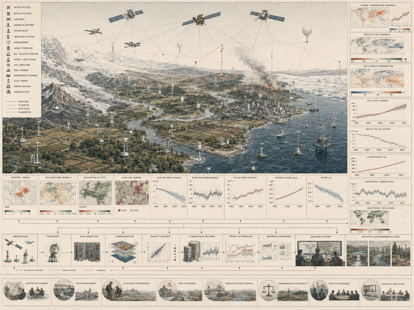
What Are Climate Monitoring Systems?
Climate monitoring systems are integrated observational systems designed to measure variables relevant to the state, variability, and long-term evolution of the climate system. They include surface observing stations, upper-air measurements, ocean observing systems, cryosphere monitoring networks, satellite missions, climate reference networks, data archives, and record-construction methods used to transform heterogeneous observations into comparable climate information.
These systems often include surface station networks measuring temperature, precipitation, humidity, pressure, radiation, wind, and related atmospheric conditions; upper-air observations such as radiosondes and atmospheric profiling systems; ocean observing systems including buoys, Argo floats, tide gauges, moorings, research vessels, and autonomous platforms; satellite systems for atmosphere, land, ocean, and cryosphere observation; reference networks designed for temporal stability and calibration continuity; and metadata, archives, and processing systems used to maintain climate data records across decades. The Global Climate Observing System’s Essential Climate Variables framework provides one major international structure for prioritizing sustained climate observation across atmosphere, ocean, and land domains.
The defining feature of climate monitoring is not simply what it measures, but how it preserves comparability over time. A system becomes climate-relevant when it allows change to be interpreted against baselines, historical context, known uncertainties, and documented observational limitations. Climate monitoring therefore differs from ordinary sensing in its commitment to long-duration interpretability. It is an infrastructure for continuity, not just for acquisition.
| Monitoring Form | Primary Question | Typical Evidence | Main Risk |
|---|---|---|---|
| Climate reference networks | How can stable, high-quality observations anchor long-term climate records? | Carefully sited stations, high-quality instruments, redundant sensors, stable protocols | Reference-quality design is confused with ordinary operational monitoring. |
| Atmospheric climate monitoring | How are temperature, precipitation, humidity, pressure, radiation, winds, aerosols, and greenhouse gases changing? | Surface stations, upper-air observations, atmospheric composition networks, satellites | Instrument, siting, and network changes distort long-term comparability. |
| Ocean climate monitoring | How are sea level, ocean heat, salinity, circulation, carbon, and marine conditions changing? | Argo floats, buoys, tide gauges, ships, satellites, moorings | Sparse historical ocean coverage weakens long-term baselines. |
| Cryosphere monitoring | How are glaciers, ice sheets, snow, sea ice, and permafrost changing? | Satellite products, field surveys, mass-balance records, snow networks, permafrost stations | Remote regions and harsh environments create gaps and measurement difficulty. |
| Land and biosphere monitoring | How are land surface, vegetation, soil moisture, fire, carbon, and hydrology responding? | Remote sensing, flux towers, soil networks, hydrological records, ecological monitoring | Climate signals are entangled with land use, management, disturbance, and ecological dynamics. |
| Reanalysis and integrated climate records | How can observations and models reconstruct coherent historical climate states? | Assimilated fields, gridded datasets, uncertainty estimates, climate reanalysis products | Model-assisted reconstructions are mistaken for direct observation. |
Climate monitoring systems are therefore more than environmental sensor networks. They are infrastructures for constructing trustworthy histories of Earth-system change.
Why Climate Monitoring Matters
Climate monitoring matters because climate change emerges through variability, lag, interaction, and cumulative transformation. Seasonal cycles, interannual oscillations, abrupt events, regional heterogeneity, instrument change, and processing revision can all obscure longer-term structural shifts unless observations are sustained, standardized, contextualized, and integrated. Climate monitoring provides the empirical discipline needed to distinguish signal from noise, persistent change from transient fluctuation, and local anomaly from Earth-system trend.
It matters scientifically because trend detection, model evaluation, reanalysis, and attribution all depend on reliable observational records. It matters operationally because climate services, water management, agricultural planning, disaster preparedness, infrastructure design, public health, insurance, energy planning, and adaptation strategy require grounded knowledge of how environmental baselines are already shifting. It matters politically because climate governance depends on shared evidence about the condition of the Earth system. Without sustained monitoring, planetary change becomes easier to underestimate, fragment, delay, or contest.
Climate monitoring also matters because many of the most consequential climate dynamics are cumulative rather than immediately perceptible. Ocean heat uptake, glacier mass loss, permafrost thaw, soil moisture shifts, sea-level rise, and changing extremes may unfold gradually relative to everyday perception, even when their long-run consequences are profound. Monitoring systems make these slow transformations observable, comparable, and historically accountable.
| Need | Monitoring Contribution | Risk Without Strong Monitoring |
|---|---|---|
| Trend detection | Builds long-duration records that distinguish persistent change from variability. | Climate signals remain uncertain or politically disputable. |
| Model evaluation | Provides empirical records used to test simulations and constrain projections. | Models cannot be adequately checked against observed reality. |
| Reanalysis | Supplies observations for physically consistent reconstruction of historical climate states. | Historical climate intelligence becomes weaker and less spatially coherent. |
| Adaptation planning | Reveals changing baselines for water, heat, agriculture, infrastructure, coasts, health, and ecosystems. | Planning relies on outdated assumptions about environmental stability. |
| Public accountability | Creates inspectable evidence for assessment, policy, public communication, and institutional responsibility. | Claims about planetary change become harder to verify or contest. |
| Equitable climate knowledge | Identifies under-observed places, communities, regions, oceans, and ecosystems. | Climate risk remains less visible where monitoring capacity is weakest. |
Climate monitoring matters because climate change is not simply experienced; it must be measured, stabilized as evidence, and made historically intelligible.
Climate Monitoring as Epistemic Infrastructure
A true synthesis of climate monitoring requires treating it as epistemic infrastructure rather than as passive data collection. Climate monitoring organizes the conditions under which the Earth system becomes knowable. It determines which variables are observed continuously, which temporal scales are preserved, what forms of uncertainty are tolerated, how changes in instrumentation are managed, how records are revised, and how disparate measurements are rendered commensurable across time and space.
This is why climate monitoring is inseparable from record construction. The climate system is not observed through a single stable apparatus. It is observed through changing generations of stations, satellites, ocean platforms, measurement protocols, processing pipelines, archives, and institutional arrangements. The work of climate monitoring is therefore not exhausted at the moment of measurement. It continues through metadata preservation, calibration, homogenization, cross-platform comparison, gap handling, dataset versioning, and archival stewardship. Climate knowledge depends on these practices because what scientists and institutions ultimately use are not raw observations alone, but climate records: curated, quality-controlled, historically interpretable representations of environmental change.
In this sense, climate monitoring is a knowledge infrastructure in the strongest sense. It does not merely gather information from the Earth system; it stabilizes observational meaning across time. Without that stabilization, climate change would remain partially visible but analytically fragile. With it, the planet becomes legible as a changing system.
| Monitoring Choice | What Becomes More Visible | What May Remain Less Visible |
|---|---|---|
| Long surface temperature records | Historical warming, regional baselines, heat anomalies, and long-term shifts. | Oceans, vertical structure, urbanization artifacts, sparse historical regions. |
| Satellite Earth observation | Planetary-scale land, ocean, atmosphere, cryosphere, cloud, vegetation, and sea-level patterns. | Long pre-satellite baselines, local ground truth, and retrieval uncertainty. |
| Ocean observing systems | Ocean heat uptake, salinity, sea-level dynamics, circulation, and marine climate change. | Deep-ocean gaps, historical sparsity, coastal complexity, biogeochemical detail. |
| Cryosphere monitoring | Glacier loss, sea ice change, snow cover, ice-sheet dynamics, and permafrost conditions. | Remote field conditions, subsurface processes, long historical continuity. |
| Climate reference networks | Stable, high-quality anchor records for detecting national or regional climate trends. | Global coverage if reference networks are limited to specific countries or regions. |
| Reanalysis systems | Continuous gridded reconstructions across space and time. | Observation gaps and model assumptions embedded inside reconstructed fields. |
Climate monitoring is powerful because it gives environmental change a history. It is risky when that history is treated as self-evident rather than carefully constructed.
Observing a Coupled Earth System
Climate monitoring must be understood in Earth-system terms because the climate system is coupled. Atmosphere, ocean, land, cryosphere, biosphere, and human systems interact through exchanges of energy, moisture, momentum, carbon, nutrients, land cover, and disturbance. Temperature trends alter snow and ice. Cryosphere loss affects albedo, hydrology, sea level, and regional circulation. Ocean heat uptake influences sea level, storm potential, stratification, marine ecosystems, and atmospheric processes. Soil moisture affects heat extremes, drought, vegetation stress, and fire risk. Vegetation shifts feed back into carbon dynamics, evapotranspiration, fire regimes, and surface properties.
No single domain can be monitored adequately in isolation if the goal is to understand climate change as a systemic process. Climate monitoring is not simply a portfolio of observational subfields. It is a coordinated attempt to observe coupled dynamics across domains with different time scales, spatial structures, and instrumental challenges. Atmospheric records may be dense but historically complex. Ocean observations are globally important yet logistically difficult. Cryosphere measurements often occur in remote and rapidly changing regions. Land and biosphere signals may be mediated by land use, fire, hydrology, ecological disturbance, and human intervention.
The problem is therefore not only to monitor individual variables, but to preserve enough integrative capacity to understand how change propagates through the Earth system. From this perspective, climate monitoring is closely aligned with systems modeling. Observations do not simply populate datasets; they provide the empirical scaffolding needed to understand interactions, feedbacks, thresholds, and emergent change across an evolving planetary system.
| Domain | Key Climate Signals | Monitoring Challenge | System Connection |
|---|---|---|---|
| Atmosphere | Temperature, precipitation, humidity, circulation, aerosols, greenhouse gases. | Separating climate trends from weather variability and instrument history. | Drives energy balance, hydrology, extremes, and atmospheric composition change. |
| Ocean | Heat content, salinity, sea level, currents, carbon uptake, stratification. | Deep, sparse, expensive, and historically uneven observation. | Stores heat, absorbs carbon, shapes weather, and drives sea-level change. |
| Cryosphere | Glacier mass balance, sea ice extent, ice sheets, snow cover, permafrost. | Remote locations, harsh field conditions, rapidly changing surfaces. | Affects albedo, hydrology, ecosystems, infrastructure, and sea level. |
| Land | Soil moisture, land temperature, water storage, fire, land cover, drought stress. | Separating climate signal from land use, management, and disturbance. | Connects climate to agriculture, ecosystems, water, fire, and human settlement. |
| Biosphere | Vegetation condition, carbon flux, phenology, ecosystem stress, biodiversity response. | Ecological signals are nonlinear, lagged, and mediated by disturbance. | Regulates carbon, water, energy exchange, habitat, and resilience. |
| Human systems | Emissions, land use, infrastructure exposure, vulnerability, adaptation response. | Social data are uneven, political, and institutionally fragmented. | Human activity drives climate change and experiences its impacts unequally. |
Climate monitoring must therefore preserve both domain-specific precision and cross-domain interpretability. Earth-system change is not the sum of isolated indicators. It is the pattern created by their interaction.
Essential Climate Variables and the Logic of Observation
Because the Earth system is vast and observational resources are finite, climate monitoring requires principles of prioritization. One of the most influential is the framework of Essential Climate Variables, developed through the Global Climate Observing System. The ECV concept identifies variables considered scientifically important and operationally feasible to observe on a sustained basis across atmosphere, ocean, land, and cryosphere domains.
| Domain | Representative Variables | Monitoring Role | Continuity Challenge |
|---|---|---|---|
| Atmospheric surface | Surface temperature, precipitation, pressure, radiation, wind, water vapor. | Tracks near-surface climate conditions and changing extremes. | Station relocation, urbanization, instrument changes, and uneven historical density. |
| Upper atmosphere | Upper-air temperature, water vapor, wind, clouds, radiation. | Constrains vertical climate structure, circulation, and model evaluation. | Radiosonde changes, satellite retrieval complexity, vertical-resolution differences. |
| Atmospheric composition | Carbon dioxide, methane, ozone, aerosols, other greenhouse gases and reactive species. | Tracks drivers of climate forcing and air-climate interactions. | Calibration, network representativeness, laboratory standards, and long-term traceability. |
| Ocean physical | Sea surface temperature, ocean heat content, salinity, sea level, currents, sea state. | Monitors heat uptake, circulation, stratification, and sea-level change. | Historical sparsity, deep-ocean coverage, platform transitions, and calibration consistency. |
| Ocean biogeochemical and ecosystem | Ocean carbon, oxygen, nutrients, acidity, phytoplankton, marine habitat indicators. | Connects climate change to ocean chemistry and marine ecosystem response. | Lower observational density and complex sampling requirements. |
| Land and hydrology | Soil moisture, snow, glaciers, permafrost, terrestrial water storage, land cover, fire. | Tracks climate effects on water, cryosphere, ecosystems, agriculture, and disturbance. | Remote access, land-use confounding, ecological lag, and measurement heterogeneity. |
The importance of the ECV framework lies in its systems logic. It recognizes that climate monitoring is not a neutral accumulation of all possible measurements, but a structured observational strategy oriented toward what must be known to characterize change in the Earth system. ECVs provide a conceptual bridge between scientific relevance, operational design, and international coordination.
Key Analytical Distinctions
Climate monitoring is not the same as weather observation. Weather systems emphasize short-term atmospheric states and forecast horizons from hours to days. Climate monitoring may rely on many of the same observational assets, but its core purpose is the construction of long-term records capable of revealing trends, variability, baseline shifts, and changing extremes over years to decades.
Observations are not the same as climate records. A raw measurement becomes part of a climate record only when issues of calibration, metadata, continuity, instrument change, siting, processing, and comparability are addressed. Records are constructed, not merely collected.
Monitoring is not the same as reanalysis. Monitoring provides observations and records. Reanalysis systems integrate observations with physically consistent models to reconstruct historical states of the atmosphere, ocean, or land surface. Reanalysis expands climate intelligence, but remains dependent on the quantity, quality, distribution, and assumptions of the underlying observations.
Monitoring is not the same as climate services. Monitoring supplies the empirical basis. Climate services translate observed and modeled knowledge into decision-relevant guidance for sectors such as agriculture, water, infrastructure, public health, insurance, energy, disaster management, and adaptation planning.
Detection is not the same as attribution. Detection asks whether a change exceeds expected variability; attribution asks which processes or forcings best explain it. Monitoring is necessary for both, but does not by itself resolve the full attribution problem.
Satellite observation does not replace in situ measurement. Satellite systems provide broad spatial coverage and continuity at planetary scale, but in situ observations remain indispensable for calibration, validation, vertical detail, local interpretation, and variables not directly recoverable from orbital sensing alone. Robust climate monitoring depends on integration, not substitution.
| Distinction | Why It Matters | Design Implication |
|---|---|---|
| Weather observation versus climate monitoring | Short-term operational data and long-term climate records have different evidence requirements. | Maintain separate valid-use statements for forecast use and climate-record use. |
| Observation versus record | Raw values require processing and context before supporting climate claims. | Preserve metadata, QC, calibration, homogenization, and version history. |
| Climate record versus indicator | Indicators summarize records but may hide uncertainty, coverage, and processing assumptions. | Link indicators to underlying datasets and public evidence packages. |
| Monitoring versus reanalysis | Reanalysis is model-assisted reconstruction, not direct observation. | Document assimilation method, model assumptions, and uncertainty. |
| Detection versus attribution | Observed change and causal explanation are related but distinct evidentiary steps. | Separate trend detection from attribution claims and cite supporting methods. |
| Global coverage versus observational equity | Global products can conceal regional weakness or sparse in situ validation. | Audit regional, ocean, polar, and lower-capacity observation gaps. |
These distinctions prevent climate monitoring from being reduced to dashboards or datasets. The system’s purpose is to sustain interpretable evidence about change through time.
System Architecture: From Observation to Climate Record
Climate monitoring systems operate as layered architectures that connect measurement to long-term interpretability. Observations are collected through stations, radiosondes, buoys, floats, ships, aircraft, satellite instruments, field campaigns, reference networks, and ecological or hydrological monitoring systems. Signals are sampled, time-stamped, georeferenced, encoded, and stored in structured forms. Calibration and metadata capture document instrument behavior, site history, procedural changes, retrieval algorithms, orbital conditions, data provenance, and observational context. Observations move into national and international data systems that preserve access and continuity. Quality-control and homogenization workflows check for errors, discontinuities, biases, missingness, and non-climatic artifacts. Record-construction processes integrate heterogeneous observations into internally consistent climate data records. Analysis workflows identify trends, anomalies, variability, extremes, and coupled-system patterns. Institutions then use this information for assessment, adaptation, infrastructure planning, climate services, and long-horizon governance.
| Stage | Transformation | Failure Risk |
|---|---|---|
| Earth-system process | Climate variables evolve across atmosphere, ocean, land, cryosphere, biosphere, and human systems. | Monitoring design fails to capture the relevant variable, scale, or coupling. |
| Observation | Stations, satellites, ocean platforms, cryosphere networks, and field systems collect measurements. | Platform limits are mistaken for climate reality. |
| Metadata capture | Location, instrument, method, calibration, platform, algorithm, and processing context are recorded. | Records become historically ambiguous. |
| Archiving | Observations and metadata are preserved in durable repositories. | Data are lost, orphaned, undocumented, or inaccessible. |
| Quality control | Errors, missingness, suspicious values, and internal inconsistencies are flagged. | Faulty observations distort climate records. |
| Homogenization | Non-climatic discontinuities are detected and documented, and adjusted where appropriate. | Station moves or platform changes are misread as climate change. |
| Record construction | Validated observations become versioned climate data records and indicators. | Records are published without transparent methods or uncertainty. |
| Assessment and decision use | Climate records support trends, attribution, model evaluation, adaptation, and governance. | Public claims exceed the evidence quality of the record. |
This architecture shows why continuity is a scientific achievement rather than a passive byproduct. Climate records must survive technological transition, shifting institutions, evolving processing methods, and uneven observational density. What makes climate monitoring powerful is the disciplined preservation of comparability through those changes.
Major Domains of Climate Observation
Climate monitoring spans multiple Earth-system domains, each contributing distinct but interdependent forms of evidence. Atmospheric monitoring includes surface and upper-air temperature, humidity, pressure, winds, clouds, aerosols, radiation, precipitation, and greenhouse gas concentrations. These observations are essential for documenting warming, circulation shifts, extremes, and atmospheric composition change.
Ocean monitoring includes sea surface temperature, subsurface temperature, salinity, sea level, circulation, ocean heat content, waves, oxygen, acidity, nutrients, and marine carbon variables. Because the ocean absorbs most of the excess heat added to the climate system, ocean observation is indispensable for understanding long-term planetary energy imbalance and sea-level change.
Cryosphere monitoring includes glaciers, snow cover, sea ice, permafrost, ice shelves, and ice sheets. These systems are both sensitive indicators of warming and active participants in climate dynamics through albedo, freshwater fluxes, hydrology, ecosystems, infrastructure risk, and sea-level effects.
Land monitoring includes soil moisture, land surface temperature, terrestrial water storage, vegetation state, fire, drought, land-cover change, and ecosystem stress. These variables connect climate dynamics to ecosystems, agriculture, hydrology, biodiversity, food systems, and regional resilience.
Integrated Earth observation links these domains through shared data infrastructures, comparative frameworks, analytical methods, and reanalysis systems. Its purpose is not merely to juxtapose variables, but to preserve the possibility of understanding climate as a coupled and evolving system.
| Domain | Representative Evidence | Core Use | Continuity Risk |
|---|---|---|---|
| Atmosphere | Temperature, precipitation, humidity, pressure, wind, clouds, radiation, aerosols, greenhouse gases. | Warming, extremes, atmospheric composition, circulation, and forcing assessment. | Instrument changes, station moves, sparse historical records, and urbanization effects. |
| Ocean | Sea surface temperature, ocean heat content, salinity, sea level, currents, carbon, oxygen, acidity. | Planetary energy imbalance, sea-level rise, circulation, and marine climate change. | Historical sparsity, deep-ocean gaps, platform transitions, and calibration complexity. |
| Cryosphere | Sea ice, glaciers, ice sheets, snow cover, permafrost, ice shelves. | Warming indicators, hydrology, albedo feedback, infrastructure risk, and sea-level contribution. | Remote field conditions, limited in situ coverage, and rapidly changing surfaces. |
| Land and hydrology | Soil moisture, river flow, terrestrial water storage, drought, fire, land cover, land temperature. | Water security, drought risk, ecosystems, agriculture, and regional adaptation. | Land-use confounding, hydrological modification, sparse monitoring, and non-climatic disturbance. |
| Biosphere and carbon | Vegetation condition, flux towers, biomass, phenology, fire emissions, carbon exchange. | Carbon-cycle dynamics, ecosystem stress, biodiversity, land-atmosphere feedbacks. | Ecological lag, disturbance, measurement heterogeneity, and attribution complexity. |
The domain structure matters because climate change is not one variable. It is an Earth-system transformation revealed through many interdependent records.
Calibration, Homogenization, and Data Stewardship
Climate monitoring places unusual weight on calibration, homogenization, and stewardship because long-term comparability is fragile. Measurements may be technically sound at the moment of collection yet still distort long-term interpretation if changes in instruments, siting, procedures, orbit, retrieval algorithms, processing pipelines, or sampling density are not adequately documented and addressed.
Major challenges include instrument replacement and evolving sensor characteristics; station relocation or altered surroundings; urbanization and land-use change near observation sites; orbital drift, sensor degradation, and cross-mission discontinuity in satellite systems; changing temporal frequency and spatial density of observations; gaps, missing records, rescued archives, and incomplete metadata; and integration of heterogeneous observational platforms into unified records.
Homogenization is therefore a methodological necessity, not a technical afterthought. It refers to the effort to identify and address non-climatic discontinuities so that long-term changes in the record reflect environmental change rather than artifacts of observing practice. Likewise, climate reference networks are valuable because they prioritize stability, calibration discipline, and continuity, providing anchor observations against which broader systems can be interpreted. The U.S. Climate Reference Network is one operational example of this principle.
Data stewardship also includes archival labor. Historical station notes, early instrument logs, ship records, field notebooks, analog archives, and legacy satellite documentation may become vital for reconstructing baselines or validating trends. Climate monitoring is therefore both a future-oriented scientific enterprise and a historical one. The past must be preserved in order for change to be known.
| Practice | Purpose | Evidence Artifact | Failure Risk |
|---|---|---|---|
| Calibration | Maintains measurement traceability and comparability. | Calibration log, reference standard, instrument record. | Sensor drift appears as environmental change. |
| Metadata preservation | Documents station, instrument, site, method, ownership, algorithm, and processing history. | Metadata registry, station history, provenance record. | Records lose interpretability across time. |
| Homogenization | Detects and documents non-climatic discontinuities. | Break-point log, adjustment record, uncertainty table. | Artificial changes distort trend estimates. |
| Intercalibration | Aligns platforms, sensors, missions, or observing generations. | Overlap-period comparison, cross-platform validation. | Platform transitions produce false shifts. |
| Version control | Makes dataset revisions visible and reproducible. | Dataset version, changelog, processing manifest. | Public claims become difficult to reproduce. |
| Archival stewardship | Preserves historical observations and documentation. | Archive inventory, rescue record, digitization log. | Baselines weaken or disappear. |
| Uncertainty documentation | Communicates record confidence, coverage gaps, and valid-use limits. | Uncertainty statement, coverage audit, public caveat. | Indicators appear more certain than the record supports. |
Climate monitoring is trustworthy when its record-construction practices are inspectable. The credibility of climate evidence depends not only on the observations, but on the stewardship that preserves their meaning.
Monitoring, Reanalysis, and Climate Intelligence
Climate monitoring becomes especially consequential when observations are integrated into reanalysis, model evaluation, and climate intelligence systems. Reanalysis products combine observations with physically consistent models to reconstruct past atmospheric, oceanic, or land-surface states across space and time. They do not replace observation; rather, they extend its interpretive value by providing continuous fields, dynamically coherent histories, and comparative frameworks for scientific analysis.
Observational records support trend detection in temperature, precipitation, cryosphere state, sea level, and ocean heat; analysis of anomalies, variability, and evolving extremes; evaluation and benchmarking of climate models; assimilation into reanalysis systems that reconstruct historical climate states; detection and attribution studies linking observed change to likely drivers; and climate services that translate observation and model evidence into planning guidance. Copernicus ERA5, for example, provides a major reanalysis record for global climate and weather from 1940 onward, but its value depends on both model structure and the observing systems assimilated into it.
This is where climate monitoring becomes climate intelligence. Observations are no longer treated merely as measurements of isolated variables, but as empirical constraints on explanation, scenario comparison, decision support, and institutional foresight. Monitoring anchors the interpretive chain that runs from observation to assessment to action.
| Workflow | Observation Role | Primary Output | Key Caveat |
|---|---|---|---|
| Climate data record construction | Transforms observations into comparable, versioned records. | Temperature, precipitation, sea-level, ocean, cryosphere, and land records. | Records depend on QC, metadata, and homogenization. |
| Climate indicators | Summarizes records into interpretable measures of change. | Anomalies, trends, indices, extremes, and status indicators. | Indicators can hide dataset assumptions and uncertainty. |
| Reanalysis | Assimilates observations into model-based reconstructions. | Continuous gridded Earth-system histories. | Reanalysis is not direct observation. |
| Model evaluation | Compares simulated climate behavior with observed records. | Model skill assessment, bias evaluation, scenario credibility. | Observational uncertainty affects model assessment. |
| Detection and attribution | Provides empirical records of change and variability. | Evidence about whether and why climate change is occurring. | Attribution requires additional modeling and statistical analysis. |
| Climate services | Translates records and projections into sector-relevant knowledge. | Decision guidance for water, agriculture, infrastructure, health, and risk planning. | Usefulness depends on local relevance and uncertainty communication. |
Reanalysis and climate intelligence expand the value of climate monitoring, but they do not remove the need for strong observation. They make the quality of observation even more consequential.
Governance, Observational Asymmetry, and Planetary Accountability
Climate monitoring is inherently international because the climate system is global and coupled. No single country can observe or understand it adequately in isolation. International coordination is required to align standards, support data exchange, maintain continuity, prioritize observing efforts, and reduce dangerous gaps across land, ocean, atmosphere, cryosphere, biosphere, and human-system domains.
Yet climate monitoring is also marked by observational asymmetry. Some regions have dense and historically rich records; others remain observationally sparse. Polar regions, open oceans, mountains, small islands, lower-capacity institutional environments, and conflict-affected places present distinctive challenges. Historical archives may be unevenly preserved. Satellite coverage can reduce some of these disparities, but not eliminate them. As a result, the geography of observation is never identical to the geography of climate risk.
This asymmetry matters scientifically and politically. What is weakly observed is often weakly modeled, weakly assessed, or more vulnerable to uncertainty-based dismissal. Observational inequality can shape whose climate realities become most legible in global assessments and whose adaptation needs are supported by robust evidence. Climate monitoring therefore has an ethical as well as scientific dimension. To strengthen observation is, in many cases, to strengthen inclusion within planetary knowledge.
Climate monitoring also underpins planetary accountability. Long-term records help define the evidentiary basis for international negotiations, adaptation plans, infrastructure standards, public understanding, environmental litigation, and institutional responsibility. They make planetary change empirically harder to deny, while also revealing the limits of current preparedness. In this sense, climate monitoring systems are not simply data systems; they are infrastructures through which claims about the changing Earth can be tested against history.
| Governance Responsibility | Question | Evidence |
|---|---|---|
| Standards governance | Are variables, methods, units, metadata, and exchange formats aligned across institutions? | Data dictionary, observation standard, exchange protocol, ECV mapping |
| Stewardship governance | Who preserves observations, metadata, archives, processing pipelines, and dataset versions? | Stewardship plan, archive record, dataset version log |
| Calibration governance | How are instrument changes, reference standards, and platform transitions documented? | Calibration log, overlap record, intercomparison file |
| Revision governance | How are record updates, corrections, and reprocessing events made transparent? | Changelog, revision policy, reproducible processing manifest |
| Coverage governance | Which regions, domains, variables, or communities remain under-observed? | Coverage audit, gap map, investment-priority record |
| Public evidence governance | Can climate claims be inspected, reproduced, and caveated? | Public evidence package, citation record, uncertainty statement |
| Equity governance | Does monitoring capacity support the climate realities of vulnerable and underrepresented regions? | Observational equity review, capacity-building plan, regional data partnership |
Climate monitoring becomes trustworthy when governance connects scientific continuity, public evidence, data stewardship, observational equity, and accountability.
Future Directions
The future of climate monitoring lies in deeper integration across in situ networks, satellite systems, cloud-based data infrastructures, reanalysis workflows, open data platforms, and decision-support systems. Greater interoperability, improved cross-platform calibration, near-real-time access, stronger data provenance, and better links between observations and decision systems are making climate information more usable across scales. At the same time, demands on the observing system are intensifying: finer spatial resolution, stronger continuity, improved polar and ocean coverage, richer biosphere observation, better urban and regional climate records, and more explicit support for adaptation and resilience planning.
The central strategic challenge, however, is not simply to gather more data. It is to preserve trustworthy records through technological transition and institutional change. Climate monitoring systems must remain historically interpretable even as instruments, missions, data architectures, algorithms, retrieval methods, and governance frameworks evolve. They must also become more inclusive, with stronger observational capacity in under-monitored regions and better integration of global, regional, local, and community-relevant climate knowledge.
Artificial intelligence and machine learning will increasingly affect climate record construction, anomaly detection, data rescue, gap filling, quality control, reanalysis, and indicator generation. These tools can improve pattern recognition and processing speed, but they also increase the need for provenance, validation, uncertainty communication, and governance. A climate record that becomes computationally sophisticated but less transparent is not automatically stronger. The future of climate monitoring must therefore combine advanced analytics with stronger stewardship.
Climate monitoring systems are evolving from specialist scientific infrastructures into core components of planetary governance. They allow societies to detect long-run change, evaluate claims about the Earth system, constrain models and scenarios, plan under accelerating instability, and hold public institutions accountable to observed reality. Where monitoring is strong, adaptation can be more realistic, assessment more credible, and public knowledge more grounded. Where monitoring is weak, both science and governance are more vulnerable to illusion. The ability to monitor climate well will increasingly determine not only what humanity knows about planetary change, but how intelligently it responds.
Deployment Readiness Gate
Before a climate monitoring system is used for trend detection, climate assessment, reanalysis, model evaluation, adaptation planning, infrastructure standards, public reporting, environmental accountability, or climate services, it should pass a deployment readiness gate. This gate should test whether records are continuous, calibrated, metadata-rich, quality-controlled, homogenization-ready, versioned, uncertainty-aware, spatially representative, and governance-aligned.
| Readiness Area | Required Question | Pass Evidence |
|---|---|---|
| Purpose readiness | Does the system define variable, domain, geography, baseline, temporal scale, decision use, and evidence standard? | Climate monitoring objective manifest, baseline definition, variable rationale |
| Platform readiness | Are stations, satellites, ocean platforms, cryosphere sites, flux towers, or specialty systems documented? | Platform registry, station history, instrument inventory |
| Metadata readiness | Are instrument, location, siting, method, algorithm, ownership, and processing histories preserved? | Metadata registry, provenance graph, data dictionary |
| Calibration readiness | Are reference standards, sensor transitions, satellite intercalibration, and overlap periods documented? | Calibration log, intercomparison dataset, reference record |
| Record readiness | Are observations quality-controlled, versioned, and transformed into comparable climate records? | Climate data record manifest, processing pipeline, dataset version |
| Homogenization readiness | Are break points, non-climatic artifacts, missingness, and adjustments documented? | Homogenization log, adjustment table, uncertainty estimate |
| Coverage readiness | Are spatial, temporal, vertical, ocean, polar, and lower-capacity-region gaps identified? | Coverage audit, gap map, continuity report |
| Uncertainty readiness | Are record limitations, processing assumptions, coverage constraints, and valid-use caveats exposed? | Uncertainty statement, public evidence package, citation record |
| Governance readiness | Are stewardship, revision, access, citation, archive, equity, and accountability responsibilities documented? | Governance log, stewardship plan, revision policy, public record |
This readiness gate prevents climate monitoring from being treated as complete merely because measurements exist. The stronger standard is whether the system can sustain trustworthy climate records through time.
Data and Configuration Artifacts
A reproducible climate-monitoring workflow should include explicit artifacts for objectives, platforms, metadata, calibration, observations, quality control, homogenization, records, indicators, reanalysis linkage, coverage, uncertainty, and governance. These artifacts make climate claims auditable rather than hidden inside processed datasets, figures, reports, dashboards, or institutional memory.
| Artifact | Purpose | Suggested Path |
|---|---|---|
| Climate monitoring objective manifest | Defines climate variable, domain, geography, baseline, temporal scale, and decision use. | config/climate_monitoring_objective.yml |
| Observation platform registry | Stores stations, satellites, ocean platforms, cryosphere sites, flux towers, and specialty networks. | data/climate_observation_platform_registry.csv |
| Metadata and provenance registry | Documents instruments, locations, methods, algorithms, station history, and processing lineage. | data/metadata_provenance_registry.csv |
| Calibration and intercomparison log | Tracks reference standards, overlap periods, instrument transitions, satellite cross-calibration, and method changes. | data/calibration_intercomparison_log.csv |
| Climate observation records | Stores raw and quality-controlled climate observations with time, units, platform, flags, and provenance. | data/climate_observation_records.csv |
| Homogenization and adjustment log | Records break points, non-climatic artifacts, adjustment methods, and uncertainty effects. | data/homogenization_adjustment_log.csv |
| Climate data record manifest | Defines record version, coverage, processing method, citation, uncertainty, and valid-use limits. | data/climate_data_record_manifest.csv |
| Indicator and anomaly table | Calculates baselines, anomalies, trends, and climate indicators. | data/climate_indicator_anomaly_table.csv |
| Coverage and continuity audit | Identifies temporal gaps, spatial gaps, platform transitions, domain gaps, and under-observed regions. | data/coverage_continuity_audit.csv |
| Governance and public evidence log | Tracks citations, caveats, stewardship decisions, record revisions, and public accountability. | data/climate_monitoring_governance_log.csv |
These artifacts turn climate monitoring into a reproducible record-stewardship system rather than a loose collection of measurements, indicators, and public claims.
Mathematical Lens: Baselines, Anomalies, Trends, Continuity, and Record Quality
Several simple metrics can help evaluate climate-monitoring readiness. These metrics are not substitutes for climate science, homogenization methods, attribution studies, or expert judgment, but they make climate-record quality more inspectable.
A_t = X_t – \bar{X}_{B}
\]
Interpretation: A climate anomaly compares a value at time \(t\) against a defined baseline period. Baseline choice must be transparent.
X_t = \alpha + \beta t + \varepsilon_t
\]
Interpretation: A simple trend model estimates systematic change through time. Real climate analysis should handle variability, autocorrelation, missingness, and uncertainty.
C_{\mathrm{record}} =
\frac{N_{\mathrm{valid\ time\ steps}}}{N_{\mathrm{expected\ time\ steps}}}
\]
Interpretation: Record continuity measures the share of expected time steps with valid observations or accepted climate-record values.
G_{\mathrm{coverage}} =
\frac{A_{\mathrm{observed}}}{A_{\mathrm{target}}}
\]
Interpretation: Geographic coverage compares the observed area or target domain against the intended monitoring domain.
Q_{\mathrm{climate\ record}} =
w_1C_r +
w_2M_c +
w_3K_c +
w_4H_r +
w_5S_c +
w_6V_c +
w_7U_c +
w_8G_r
\]
Interpretation: Climate-record evidence quality depends on continuity, metadata completeness, calibration quality, homogenization readiness, spatial coverage, version control, uncertainty communication, and governance readiness.
These measures evaluate climate monitoring as a record-stewardship system. They ask whether the record is continuous, documented, calibrated, comparable, versioned, spatially adequate, uncertainty-aware, and accountable enough to support the claim being made.
Python Workflow: Climate Monitoring Readiness and Record-Quality Scoring
A Python workflow can demonstrate how climate monitoring programs might be evaluated for record continuity, metadata completeness, calibration quality, homogenization readiness, spatial coverage, version control, uncertainty communication, and governance readiness. The purpose is not to create a universal climate score, but to make record-quality dimensions visible.
from dataclasses import dataclass
from typing import List
import pandas as pd

@dataclass
class ClimateMonitoringProgram:
    program_id: str
    domain: str
    climate_variable: str
    record_continuity: float
    metadata_completeness: float
    calibration_quality: float
    homogenization_readiness: float
    spatial_coverage: float
    version_control: float
    uncertainty_communication: float
    governance_readiness: float
    high_stakes_use: bool

def climate_record_quality(program: ClimateMonitoringProgram) -> float:
    return (
        0.15 * program.record_continuity +
        0.13 * program.metadata_completeness +
        0.14 * program.calibration_quality +
        0.13 * program.homogenization_readiness +
        0.13 * program.spatial_coverage +
        0.11 * program.version_control +
        0.10 * program.uncertainty_communication +
        0.11 * program.governance_readiness
    )

def classify_review_priority(program: ClimateMonitoringProgram, score: float) -> str:
    if program.high_stakes_use and program.record_continuity < 0.75:
        return "high_stakes_record_continuity_review"
    if program.metadata_completeness < 0.75:
        return "metadata_completeness_review"
    if program.calibration_quality < 0.75:
        return "calibration_quality_review"
    if program.homogenization_readiness < 0.75:
        return "homogenization_readiness_review"
    if program.spatial_coverage < 0.70:
        return "spatial_coverage_review"
    if program.version_control < 0.75:
        return "version_control_review"
    if program.uncertainty_communication < 0.75:
        return "uncertainty_communication_review"
    if program.governance_readiness < 0.75:
        return "governance_readiness_review"
    if score < 0.75:
        return "climate_record_quality_review"
    return "routine_monitoring"

programs: List[ClimateMonitoringProgram] = [
    ClimateMonitoringProgram(
        "surface-temperature-reference-network",
        "atmosphere",
        "surface_temperature",
        0.92,
        0.88,
        0.90,
        0.86,
        0.78,
        0.84,
        0.82,
        0.86,
        True,
    ),
    ClimateMonitoringProgram(
        "ocean-heat-content-network",
        "ocean",
        "ocean_heat_content",
        0.78,
        0.80,
        0.84,
        0.76,
        0.68,
        0.82,
        0.78,
        0.80,
        True,
    ),
    ClimateMonitoringProgram(
        "cryosphere-mass-balance-program",
        "cryosphere",
        "glacier_mass_balance",
        0.72,
        0.76,
        0.78,
        0.74,
        0.62,
        0.76,
        0.74,
        0.78,
        True,
    ),
    ClimateMonitoringProgram(
        "land-biosphere-carbon-observation",
        "land_biosphere",
        "vegetation_carbon_flux",
        0.70,
        0.72,
        0.74,
        0.70,
        0.66,
        0.72,
        0.70,
        0.74,
        True,
    ),
]

records = []
for program in programs:
    score = climate_record_quality(program)
    records.append({
        "program_id": program.program_id,
        "domain": program.domain,
        "climate_variable": program.climate_variable,
        "record_continuity": program.record_continuity,
        "metadata_completeness": program.metadata_completeness,
        "calibration_quality": program.calibration_quality,
        "homogenization_readiness": program.homogenization_readiness,
        "spatial_coverage": program.spatial_coverage,
        "version_control": program.version_control,
        "uncertainty_communication": program.uncertainty_communication,
        "governance_readiness": program.governance_readiness,
        "climate_record_quality": round(score, 3),
        "review_priority": classify_review_priority(program, score),
    })

df = pd.DataFrame(records)
print(df.sort_values(["review_priority", "climate_record_quality"]))
This workflow treats climate monitoring programs as record-quality systems. A program is not ready merely because it measures climate-relevant variables. It must preserve enough evidence about continuity, metadata, calibration, homogenization, coverage, versioning, uncertainty, and governance to support the intended climate claim.
R Workflow: Climate Record Continuity, Trend Readiness, and Stewardship Review
An R workflow can support climate-monitoring governance by summarizing record readiness across atmospheric, oceanic, cryosphere, land, biosphere, and reanalysis-linked monitoring programs. This is useful for climate-record audits, public evidence packages, adaptation planning, and data-stewardship review.
library(dplyr)
library(readr)

climate_programs <- tribble(
  ~program_id, ~domain, ~climate_variable, ~record_continuity, ~metadata_completeness, ~calibration_quality, ~homogenization_readiness, ~spatial_coverage, ~version_control, ~uncertainty_communication, ~governance_readiness, ~high_stakes_use,
  "surface-temperature-reference-network", "atmosphere", "surface_temperature", 0.92, 0.88, 0.90, 0.86, 0.78, 0.84, 0.82, 0.86, TRUE,
  "ocean-heat-content-network", "ocean", "ocean_heat_content", 0.78, 0.80, 0.84, 0.76, 0.68, 0.82, 0.78, 0.80, TRUE,
  "cryosphere-mass-balance-program", "cryosphere", "glacier_mass_balance", 0.72, 0.76, 0.78, 0.74, 0.62, 0.76, 0.74, 0.78, TRUE,
  "land-biosphere-carbon-observation", "land_biosphere", "vegetation_carbon_flux", 0.70, 0.72, 0.74, 0.70, 0.66, 0.72, 0.70, 0.74, TRUE
)

climate_summary <- climate_programs %>%
  mutate(
    climate_record_quality = round(
      0.15 * record_continuity +
      0.13 * metadata_completeness +
      0.14 * calibration_quality +
      0.13 * homogenization_readiness +
      0.13 * spatial_coverage +
      0.11 * version_control +
      0.10 * uncertainty_communication +
      0.11 * governance_readiness,
      3
    ),
    review_priority = case_when(
      high_stakes_use & record_continuity < 0.75 ~ "high_stakes_record_continuity_review",
      metadata_completeness < 0.75 ~ "metadata_completeness_review",
      calibration_quality < 0.75 ~ "calibration_quality_review",
      homogenization_readiness < 0.75 ~ "homogenization_readiness_review",
      spatial_coverage < 0.70 ~ "spatial_coverage_review",
      version_control < 0.75 ~ "version_control_review",
      uncertainty_communication < 0.75 ~ "uncertainty_communication_review",
      governance_readiness < 0.75 ~ "governance_readiness_review",
      climate_record_quality < 0.75 ~ "climate_record_quality_review", TRUE ~ "routine_monitoring" ) ) %>%
  arrange(review_priority, climate_record_quality)

print(climate_summary)

write_csv(
  climate_summary,
  "outputs/climate_monitoring_readiness_summary.csv"
)
The R workflow emphasizes that climate-monitoring review should account for record continuity, metadata completeness, calibration quality, homogenization readiness, spatial coverage, version control, uncertainty communication, and governance. These dimensions help prevent climate records from being judged by observation availability alone.
Systems Code: Observations, Records, Metadata, Homogenization, Reanalysis, and Governance Logs
Climate monitoring depends on full-stack Earth-system data infrastructure. The stack includes observation platform registries, metadata repositories, calibration logs, raw observations, QC flags, homogenization workflows, adjustment records, record manifests, indicator tables, anomaly calculations, reanalysis links, coverage audits, archive inventories, public evidence packages, and governance logs. A serious companion repository should therefore include both analytical workflows and systems-code scaffolding.
| Language / Tool | Role in Companion Repository | Example Use |
|---|---|---|
| Python | Readiness scoring, anomaly calculation, record-quality review, metadata checks, and trend-readiness triage | Climate-record audit and review prioritization |
| R | Climate summaries, trend-ready tables, record continuity reporting, and stewardship outputs | Reporting-ready climate monitoring summaries |
| SQL | Platform registries, observations, metadata, calibration logs, homogenization records, indicators, and governance logs | Auditable climate-monitoring database schema |
| GeoJSON | Stations, reference networks, ocean platforms, cryosphere sites, and coverage gaps | Spatial registry for climate monitoring coverage |
| TypeScript | Dashboard and platform data models | Record cards, station status, anomaly panels, uncertainty and version views |
| Go | Lightweight climate-record status endpoint | Expose record continuity, metadata, calibration, and governance readiness |
| Rust | Safe validation CLI for climate records and metadata | Validate timestamps, variables, units, platform IDs, QC flags, and version fields |
| C / C++ | Low-level observation-record and bounded event-queue examples | Demonstrate embedded climate station records and data-quality event buffers |
| Shell scripts | Reproducible directory, validation, and export workflows | One-command scaffold validation and output generation |
This breadth is appropriate because climate monitoring is not only Earth observation. It is evidence infrastructure spanning measurement, metadata, calibration, archiving, record construction, reanalysis, public communication, and planetary accountability.
GitHub Repository
A companion repository for this article should translate the climate-monitoring framework into reproducible technical scaffolding. The repository should include climate monitoring objective manifests, observation platform registries, metadata and provenance tables, calibration and intercomparison logs, climate observation records, homogenization and adjustment records, climate data record manifests, anomaly and indicator workflows, coverage audits, SQL schemas, dashboard data types, and governance records.
Testing and Validation
Testing climate monitoring systems requires more than confirming that observations exist. It requires validating platform metadata, station history, instrument records, calibration logs, observation continuity, unit consistency, QC status, homogenization methods, dataset versioning, uncertainty statements, coverage gaps, archive integrity, and governance records. A system can appear data-rich while producing weak climate evidence if its records are discontinuous, poorly documented, spatially biased, uncalibrated, or unreproducible.
| Test Type | Purpose | Example Test |
|---|---|---|
| Platform metadata test | Ensure platform type, owner, location, variable, instrument, method, and status are documented. | Validate platform registry and station-history fields. |
| Record continuity test | Ensure expected observations exist across the monitoring period. | Calculate valid time steps versus expected time steps. |
| Calibration test | Ensure instruments, sensors, missions, and methods are traceable to calibration records. | Review calibration and intercomparison log. |
| Metadata completeness test | Ensure observations can be interpreted historically. | Check site history, instrument changes, processing lineage, and ownership fields. |
| Homogenization test | Ensure non-climatic discontinuities are detected, documented, and caveated. | Review break-point, adjustment, and uncertainty records. |
| Baseline and anomaly test | Ensure anomalies are calculated against a clearly defined baseline. | Validate baseline period and anomaly table. |
| Version-control test | Ensure record updates and processing revisions are reproducible. | Review dataset version, changelog, and processing manifest. |
| Coverage test | Ensure spatial, temporal, vertical, ocean, polar, and lower-capacity-region gaps are identified. | Review coverage and continuity audit. |
| Uncertainty test | Ensure caveats are attached to records, indicators, and public claims. | Check uncertainty statements and valid-use notes. |
| Governance test | Ensure stewardship, archive, citation, revision, and public evidence responsibilities are documented. | Review governance log and public evidence package. |
Validation should test the climate monitoring system as a record-construction chain. The decisive question is not whether an observation exists, but whether the record can support a claim about change through time.
Operational Signals and Climate-Monitoring Observability
Climate monitoring systems must observe themselves. A system that monitors Earth-system change but cannot report record continuity, metadata completeness, calibration status, homogenization status, dataset version, coverage gaps, uncertainty, archive integrity, and governance ownership is operationally fragile. Monitoring-system observability should track both environmental evidence and record-stewardship health.
| Signal | Why It Matters | Failure Indicator |
|---|---|---|
| Record continuity | Determines whether a time series can support trend, anomaly, or baseline analysis. | Missing periods, unexplained gaps, uneven sampling, short record length. |
| Metadata completeness | Determines whether observations remain historically interpretable. | Missing station history, instrument record, siting notes, or processing lineage. |
| Calibration status | Determines whether measurements remain traceable and comparable. | Missing calibration, unverified sensor transition, undocumented satellite drift. |
| Homogenization status | Determines whether non-climatic artifacts are identified and documented. | Unexplained break points or adjustment-free records despite known platform changes. |
| Version status | Determines whether published records are reproducible and citable. | No changelog, ambiguous dataset version, undocumented processing revision. |
| Coverage equity | Determines whether climate knowledge is spatially and institutionally uneven. | Under-observed oceans, poles, islands, mountains, or lower-capacity regions. |
| Uncertainty communication | Determines whether users understand record confidence and valid-use limits. | Indicators published without uncertainty, caveats, or coverage context. |
| Archive integrity | Determines whether historical evidence remains accessible and preserved. | Lost metadata, inaccessible archives, unrescued analog records. |
| Governance closure | Determines whether record problems lead to corrective action. | Audit findings lack owner, deadline, revision, or public notice. |
Operational observability protects climate monitoring from silent record degradation. It helps ensure that the appearance of climate evidence does not outlast the quality and accountability of the monitoring system beneath it.
Engineer and Researcher Checklist
- Define the climate variable, domain, geography, baseline period, temporal scale, decision use, and evidence standard before designing the record.
- Distinguish weather observation, climate monitoring, climate records, reanalysis, climate services, detection, and attribution.
- Document platform type, instrument, owner, location, siting, method, algorithm, processing lineage, update frequency, and operational status.
- Preserve calibration records, overlap periods, satellite intercalibration, instrument transitions, and reference-network context.
- Track raw observations, quality-controlled observations, adjusted records, dataset versions, and public indicators separately.
- Maintain metadata sufficient for future researchers to interpret the record decades later.
- Document baseline periods, anomaly calculations, trend methods, missingness, uncertainty, and valid-use limits.
- Use homogenization carefully, transparently, and reproducibly; never hide adjustment logic.
- Audit spatial, temporal, vertical, ocean, polar, mountain, island, and lower-capacity-region gaps.
- Distinguish satellite retrievals, in situ measurements, and reanalysis outputs in public claims.
- Expose uncertainty and coverage limits in climate indicators and public evidence packages.
- Use governance logs to track stewardship decisions, dataset revisions, archive responsibilities, and public-accountability commitments.
Where This Fits in the Series
This article connects Environmental Monitoring Systems to weather sensing, climate early warning, remote sensing, satellite observation, environmental data platforms, risk and resilience, Earth-system science, and long-term environmental governance. It sits at the historical-record layer of the series: the point where environmental observation becomes comparable evidence of change through time.
Within the broader series, this article provides the climate-record framework that supports weather sensing and atmospheric data systems, climate early warning systems, remote sensing systems in environmental monitoring, satellite observation and Earth-system monitoring, environmental data platforms and decision support systems, monitoring environmental risk and resilience, air quality monitoring systems, environmental sensor networks, and the future of environmental monitoring systems. Its role is to show that climate intelligence does not emerge from measurement alone. It emerges from continuity, metadata, calibration, stewardship, uncertainty, and governance.
Related articles
- Environmental Monitoring Systems
- Air Quality Monitoring Systems
- Weather Sensing and Atmospheric Data Systems
- Climate Early Warning Systems
- Remote Sensing Systems in Environmental Monitoring
- Satellite Observation and Earth System Monitoring
- Environmental Data Platforms and Decision Support Systems
- Monitoring Environmental Risk and Resilience
- Environmental Sensor Networks
- The Future of Environmental Monitoring Systems
Further reading
- Global Climate Observing System (2026) Global Climate Observing System. Available at: https://gcos.wmo.int/site/global-climate-observing-system-gcos
- Global Climate Observing System (2026) Essential Climate Variables. Available at: https://gcos.wmo.int/site/global-climate-observing-system-gcos/essential-climate-variables
- Global Climate Observing System (2026) About Essential Climate Variables. Available at: https://gcos.wmo.int/site/global-climate-observing-system-gcos/essential-climate-variables/about-essential-climate-variables
- NASA Earthdata (2026) Your Gateway to NASA Earth Observation Data. Available at: https://www.earthdata.nasa.gov/
- NASA Earthdata (2026) Climate Indicators. Available at: https://www.earthdata.nasa.gov/topics/climate-indicators
- NASA Earthdata (2026) Climate Indicators Data Access and Tools. Available at: https://www.earthdata.nasa.gov/topics/climate-indicators/data-access-tools
- National Centers for Environmental Information (2026) U.S. Climate Reference Network. Available at: https://www.ncei.noaa.gov/products/land-based-station/us-climate-reference-network
- National Centers for Environmental Information (2026) U.S. Climate Reference Network Data Access. Available at: https://www.ncei.noaa.gov/access/crn/
- National Oceanic and Atmospheric Administration (2026) Climate Monitoring Data Products. Available at: https://www.noaa.gov/ncei-climate-monitoring-data-products
- Copernicus Climate Change Service (2026) Climate Reanalysis. Available at: https://climate.copernicus.eu/climate-reanalysis
- Copernicus Climate Data Store (2026) ERA5 hourly data on single levels from 1940 to present. Available at: https://cds.climate.copernicus.eu/datasets/reanalysis-era5-single-levels
- Intergovernmental Panel on Climate Change (2023) AR6 Synthesis Report: Climate Change 2023. Available at: https://www.ipcc.ch/report/ar6/syr/
- Intergovernmental Panel on Climate Change (2026) Sixth Assessment Report. Available at: https://www.ipcc.ch/assessment-report/ar6/
References
- Copernicus Climate Change Service (2026) Climate Reanalysis. Available at: https://climate.copernicus.eu/climate-reanalysis (Accessed: 14 May 2026).
- Copernicus Climate Data Store (2026) ERA5 hourly data on single levels from 1940 to present. Available at: https://cds.climate.copernicus.eu/datasets/reanalysis-era5-single-levels (Accessed: 14 May 2026).
- Global Climate Observing System (2026) About Essential Climate Variables. Available at: https://gcos.wmo.int/site/global-climate-observing-system-gcos/essential-climate-variables/about-essential-climate-variables (Accessed: 14 May 2026).
- Global Climate Observing System (2026) Essential Climate Variables. Available at: https://gcos.wmo.int/site/global-climate-observing-system-gcos/essential-climate-variables (Accessed: 14 May 2026).
- Global Climate Observing System (2026) Global Climate Observing System. Available at: https://gcos.wmo.int/site/global-climate-observing-system-gcos (Accessed: 14 May 2026).
- Intergovernmental Panel on Climate Change (2023) AR6 Synthesis Report: Climate Change 2023. Available at: https://www.ipcc.ch/report/ar6/syr/ (Accessed: 14 May 2026).
- Intergovernmental Panel on Climate Change (2026) Sixth Assessment Report. Available at: https://www.ipcc.ch/assessment-report/ar6/ (Accessed: 14 May 2026).
- NASA Earthdata (2026) Climate Indicators. Available at: https://www.earthdata.nasa.gov/topics/climate-indicators (Accessed: 14 May 2026).
- NASA Earthdata (2026) Climate Indicators Data Access and Tools. Available at: https://www.earthdata.nasa.gov/topics/climate-indicators/data-access-tools (Accessed: 14 May 2026).
- NASA Earthdata (2026) Your Gateway to NASA Earth Observation Data. Available at: https://www.earthdata.nasa.gov/ (Accessed: 14 May 2026).
- National Centers for Environmental Information (2026) U.S. Climate Reference Network. Available at: https://www.ncei.noaa.gov/products/land-based-station/us-climate-reference-network (Accessed: 14 May 2026).
- National Centers for Environmental Information (2026) U.S. Climate Reference Network Data Access. Available at: https://www.ncei.noaa.gov/access/crn/ (Accessed: 14 May 2026).
- National Oceanic and Atmospheric Administration (2026) Climate Monitoring Data Products. Available at: https://www.noaa.gov/ncei-climate-monitoring-data-products (Accessed: 14 May 2026).