
Last Updated May 9, 2026
Urbanization, informality, and risk exposure belong together because urban growth does not distribute safety evenly. Cities concentrate people, assets, infrastructure, opportunity, services, and cultural life, but they also concentrate hazard, exclusion, infrastructure dependence, land pressure, housing precarity, and unequal access to protection. The central resilience question is not simply whether cities are growing. It is how they are growing, who gains access to serviced and secure urban space, who is pushed into hazard-prone land, and whether urban development expands protection or concentrates exposure.
Informality is often treated as a problem of incomplete modernization, weak enforcement, illegal settlement, or poor household choice. That framing is misleading. In many cities, informality is the spatial expression of exclusionary urbanization: formal land and housing markets that large populations cannot access, infrastructure that arrives late or unevenly, tenure systems that leave residents insecure, labor markets that provide income without protection, and public systems that recognize people only partially. Informality does not create risk by itself. Risk emerges when informal residents are forced to live, work, build, move, and recover under conditions where hazards are high and institutional protection is thin.
Main Library
Publications
Article Map
Risk & Resilience
Related Topic
Inequality
Related Topic
Climate Risk
Related Topic
Just Resilience
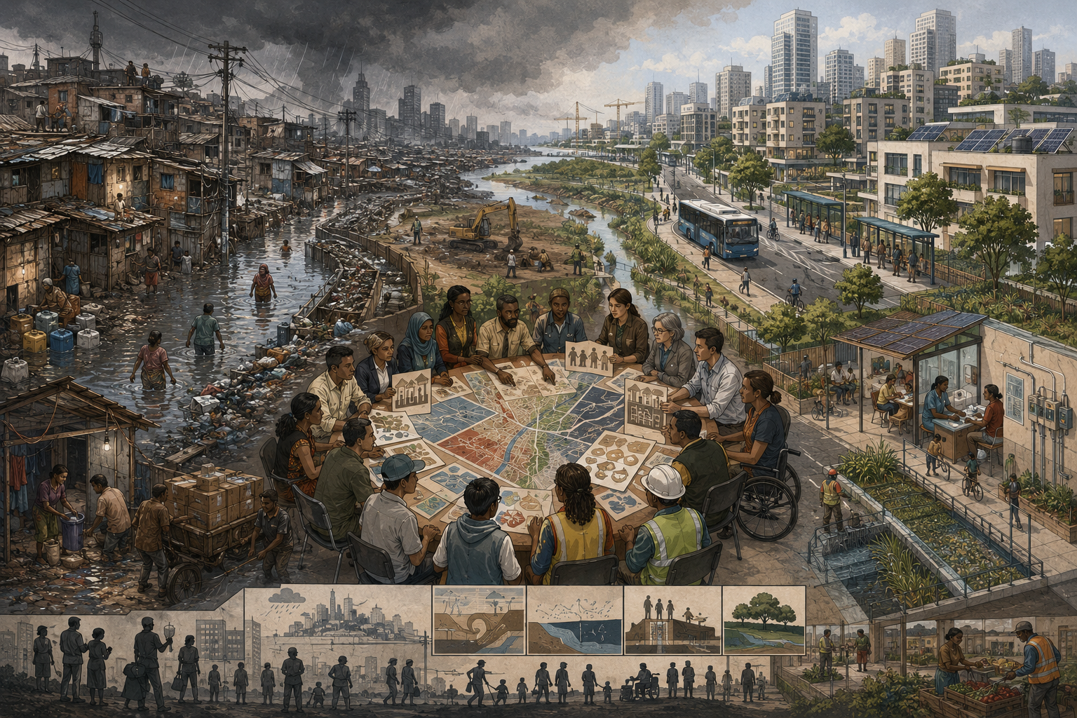
The stakes are large because the geography of future urban risk is being produced now. Rapid urbanization can expand opportunity, improve access to services, reduce per-capita infrastructure costs, support innovation, and strengthen public life. But when urban growth is exclusionary, it can also place low-income residents, migrants, informal workers, renters, and marginalized communities in the most exposed locations with the fewest buffers. Urban resilience therefore depends on land, services, housing, tenure, infrastructure, livelihoods, finance, participation, and public legitimacy together.
Why This Topic Matters
Urbanization matters to resilience because cities are where exposure, infrastructure dependence, economic opportunity, social inequality, and public governance increasingly intersect. Urban areas concentrate the systems people rely on every day: housing, transport, water, drainage, sanitation, electricity, waste management, public health, emergency response, schools, markets, finance, communications, and employment. When these systems work, cities can expand opportunity and adaptive capacity. When they fail or exclude, cities can concentrate risk at extraordinary density.
This topic matters because urban risk is not only produced by hazards. It is produced by the relationship between hazards and the urban systems that shape exposure. A heavy rainfall event becomes a disaster when drainage is weak, housing is unsafe, floodplains are occupied without protection, emergency routes are blocked, residents lack savings, and public agencies cannot respond effectively. A heatwave becomes more deadly where housing is poorly ventilated, tree canopy is scarce, outdoor work is common, electricity is unreliable, water is limited, and public-health outreach is weak. A fire, landslide, storm, disease outbreak, or infrastructure outage becomes more damaging when services and protections are unequally distributed.
Urban informality is central because it often marks where formal protection is weakest. Informal settlements may have insecure tenure, limited drainage, unsafe electrical connections, overcrowded housing, weak road access, poor sanitation, unreliable water, limited waste management, and precarious access to health and emergency services. Informal livelihoods may provide income but little insurance, paid leave, social protection, legal security, or capacity to absorb shocks.
The danger is not simply that informal settlements exist. The danger is that cities often treat informal residents as peripheral to formal urban planning while depending on their labor, service work, informal economies, social networks, and survival strategies. Residents may build the city’s economy while being denied the city’s protections.
A resilience framework that treats informality as disorder will likely produce punitive policy: eviction, clearance, exclusion, surveillance, or relocation without rights. A better resilience framework asks how exclusionary land, housing, infrastructure, and labor systems produce informality, and how inclusive upgrading can reduce risk while protecting dignity.
Urbanization will shape the future of climate adaptation, disaster risk reduction, public health, migration, infrastructure investment, and social stability. The question is whether cities will grow by distributing safety—or by concentrating danger where people have the least power to refuse it.
Urbanization as Risk Production
Urbanization is often described as demographic change: more people living in cities. In resilience terms, it is more than that. Urbanization is the production of built environments, infrastructure networks, land values, service systems, commuting patterns, housing markets, labor markets, ecological changes, and political jurisdictions. It creates the geography through which people encounter risk.
Urban growth can reduce vulnerability when it is inclusive, planned, serviced, and accountable. Dense settlement can make public transport, water systems, sanitation, schools, clinics, energy systems, and emergency services more efficient to provide. Urban economies can create jobs and social mobility. Public institutions can reach many people in concentrated space. Well-governed urbanization can increase adaptive capacity.
But urban growth can also produce exposure. If housing supply is inadequate, low-income residents may settle in floodplains, steep slopes, polluted corridors, drainage channels, under-serviced peripheries, or insecure rental markets. If transport systems are weak, people may live far from work and services. If planning excludes informal communities, infrastructure investment may bypass areas of greatest need. If land values rise without protection, adaptation projects can trigger displacement. If urban expansion consumes wetlands, floodplains, forests, and agricultural land, ecological buffers are lost.
Urban risk is therefore not accidental. It is built into land-use decisions, infrastructure priorities, tenure arrangements, zoning, finance, speculation, service delivery, and political recognition. The geography of risk often follows the geography of power.
This is why resilience planning should not begin only after hazards appear. It should be built into how cities expand. Where are new settlements forming? Are they in hazard-prone zones? Are services arriving before risk accumulates? Are renters protected? Are informal residents recognized? Are drainage, sanitation, transport, and health systems expanding with population? Are climate projections being used in land decisions? Are ecological buffers protected?
The future risk of a city is not only determined by climate scenarios. It is also determined by today’s permits, roads, settlements, informal subdivisions, drainage investments, service upgrades, rental markets, and political choices. Urbanization is risk production when it creates exposure faster than it creates protection.
Resilient urbanization must therefore be anticipatory. It should prevent future informalization of risk rather than merely respond to it after communities have already been placed in danger.
What Informality Means
Informality refers to urban arrangements that operate outside, beside, or only partially within formal systems of planning, land tenure, building regulation, labor protection, service delivery, taxation, finance, and legal recognition. It includes informal settlements, informal rental markets, informal subdivisions, informal livelihoods, informal service connections, informal transport, informal waste work, informal commerce, and informal systems of mutual aid.
Informality should not be reduced to illegality. Many informal residents are not outside the city; they are essential to the city. They work, commute, care, build, sell, repair, clean, cook, transport, recycle, and support urban economies. Their housing and livelihoods may be informal because formal systems have failed to provide affordable, serviced, secure, and accessible alternatives.
Informality also differs across contexts. Some informal settlements have long histories, strong social organization, substantial housing investment, local institutions, and community infrastructure. Others are newly formed, highly precarious, exposed to eviction, and located in dangerous environments. Some residents have partial tenure recognition. Others face constant threat of removal. Some areas have community-managed water, drainage, sanitation, and savings groups. Others have very limited services. Informality is not one condition.
From a resilience perspective, informality often means that formal buffers are thin. Residents may lack secure tenure, making it risky to invest in housing improvements. They may lack formal addresses, making it harder to access services, emergency response, voting systems, insurance, bank accounts, or public benefits. They may rely on informal work, making income unstable after shocks. They may be missing from official maps, making their needs invisible in planning.
Yet informality can also contain resilience capacities. Communities often develop mutual aid, savings groups, local leadership, informal warning systems, construction knowledge, small-scale infrastructure, social networks, and collective upgrading strategies. These capacities should not be romanticized; they often arise because formal systems fail. But they should be recognized because effective resilience policy must build with community capacity rather than erase it.
The key point is analytical: informality is not simply a risk factor located inside communities. It is a relationship between communities and formal systems. Risk grows when residents remain outside the protections of land, services, infrastructure, finance, public information, and accountable institutions.
Resilience policy should therefore ask not only how to reduce informality, but how to reduce the exclusion that makes informality dangerous.
Land, Housing, and Tenure Insecurity
Land and housing are at the center of urban risk exposure. People do not settle in hazard-prone areas because danger is attractive. They settle there because safer land is unaffordable, inaccessible, unavailable, politically controlled, legally restricted, or captured by more powerful actors. The geography of informal risk is often the geography of exclusion from secure urban land.
Tenure insecurity weakens resilience in several ways. Residents may hesitate to invest in stronger housing if eviction is possible. Public agencies may hesitate to provide infrastructure if settlements lack formal recognition. Utilities may deny official connections. Banks and insurers may not serve households without formal title. Emergency systems may lack accurate address data. Recovery programs may exclude people who cannot prove ownership or formal residence.
Housing quality also shapes risk. Poorly built homes may be more vulnerable to flood, wind, landslide, fire, heat, and disease exposure. Overcrowding can intensify health risks. Lack of ventilation can worsen heat stress and indoor air pollution. Limited access to safe electricity can increase fire risk. Weak foundations and poor drainage can make repeated flooding more damaging.
Yet housing risk should not be blamed on residents. Informal residents often build incrementally with limited resources under legal uncertainty. Many invest heavily in improving homes despite insecurity. The problem is not lack of effort. The problem is that formal systems deny secure, serviced, affordable pathways to safe urban housing.
Resilient housing policy must therefore include tenure security, anti-displacement protections, service upgrading, finance for home improvement, climate-sensitive building support, drainage, access roads, sanitation, and participatory planning. Formalization must be handled carefully. It should not become a pathway for speculation, eviction, rent increases, or loss of community control.
Land policy is also climate policy. If low-income residents are pushed to floodplains, unstable slopes, coastal edges, polluted zones, or heat-exposed peripheries, climate risk rises. If safer land is reserved only for formal markets and high-value development, adaptation becomes unequal. If public land is not used strategically for affordable housing, services, and relocation with rights, risk exposure grows.
The right to safe urbanization begins with land. Without secure and serviced places to live, resilience remains stratified.
Informal Settlements and Unequal Exposure
Informal settlements often face unequal exposure because they are more likely to be located in environmentally degraded, under-serviced, or hazard-prone locations. These may include floodplains, riverbanks, drainage corridors, steep slopes, unstable hillsides, low-lying coastal zones, industrial edges, waste sites, rail and road margins, fire-prone peripheries, or zones without adequate public infrastructure.
Exposure is not just physical location. It is the combination of hazard, vulnerability, and limited adaptive capacity. Two neighborhoods may face the same rainfall, but the one with weak drainage, insecure housing, limited road access, poor sanitation, low savings, and little political voice faces much greater risk. Two districts may experience the same heatwave, but the one with fewer trees, worse housing, unreliable electricity, outdoor labor, poor health access, and limited public cooling options faces greater danger.
Unequal exposure is also cumulative. Informal settlements may face flood risk, heat stress, sanitation risk, fire risk, eviction risk, disease exposure, and livelihood insecurity at the same time. This compounding matters because households have limited capacity to recover repeatedly. A flood may destroy work equipment. A heatwave may reduce income. An eviction threat may prevent home improvement. A disease outbreak may increase debt. Risk becomes a cycle rather than a single event.
Urban vulnerability is also shaped by scale. Smaller and medium-sized cities may have rapid growth but weaker fiscal capacity, fewer technical staff, limited planning systems, and less access to climate finance. Large cities may have more resources but deeper inequality and complex governance. Peripheral settlements may be politically invisible. Dense inner-city informal rental systems may hide risk inside buildings rather than on maps.
Informal settlements are often described as “high-risk areas,” but this phrase can be dangerous if it implies that residents are the source of risk. A more accurate phrase is “under-protected areas of concentrated exposure.” That framing keeps responsibility visible. It directs attention to land systems, infrastructure gaps, planning failures, service exclusion, and historical neglect.
The goal should not be to erase informal settlements from the city. It should be to erase the unequal exposure that makes informality dangerous.
Services, Infrastructure, and Everyday Risk
Urban risk is not only produced by rare disasters. It is produced every day through service deficits: intermittent water, poor sanitation, weak drainage, unsafe electricity, inadequate waste management, limited road access, insufficient public transport, poor health access, overcrowding, and insecure housing. These conditions turn ordinary stress into chronic vulnerability.
Drainage is a clear example. A city may experience a rainfall event that formal neighborhoods absorb with limited disruption, while under-serviced settlements face flooding, contaminated water, property loss, disease exposure, and road blockage. The difference is not only the rain. It is the drainage system, road network, housing quality, solid waste collection, land elevation, and maintenance regime.
Water and sanitation are equally central. Limited water access can worsen health risks, heat stress, caregiving burdens, and household labor. Poor sanitation can increase disease exposure, especially during flooding. Waste accumulation can block drains, attract pests, and worsen pollution. These are not secondary concerns. They are core resilience systems.
Electricity shapes risk as well. Unsafe connections increase fire danger. Unreliable power limits cooling, lighting, communication, refrigeration, medical devices, remote work, schooling, and emergency alerts. Energy insecurity can turn heatwaves into health crises and outages into livelihood crises.
Roads and transport affect emergency response and daily resilience. Narrow or unpaved access routes may delay ambulances, fire services, evacuation, waste collection, and infrastructure repair. Poor transport access can isolate residents from work, clinics, schools, cooling centers, shelters, and public offices.
Everyday risk matters because disasters often expose conditions that already existed. A flood reveals drainage inequality. A heatwave reveals housing inequality. A pandemic reveals overcrowding, insecure work, and weak services. A fire reveals unsafe electricity and limited emergency access. Resilience cannot be built only through emergency response if everyday infrastructure remains fragile.
Inclusive service upgrading is therefore resilience infrastructure. Water, sanitation, drainage, electricity, roads, waste systems, health access, public spaces, and safe housing are not merely development amenities. They are buffers that reduce the damage caused by shocks.
A city is not resilient because its central business district functions. It is resilient when essential services protect residents across the whole urban fabric.
Climate Risk, Heat, Flooding, and Urban Vulnerability
Climate change intensifies risks already produced by unequal urbanization. Heat, flooding, storms, drought, sea-level rise, water stress, disease dynamics, and infrastructure strain all interact with land use, housing, service access, ecology, and inequality. Climate risk does not arrive evenly across the city. It follows the pathways created by urban form.
Heat is especially dangerous in dense, under-serviced settlements. Poor ventilation, heat-retaining materials, overcrowding, limited tree canopy, lack of public shade, unreliable electricity, outdoor work, limited water, and poor health access can make extreme heat deadly. Heat also affects livelihoods. Outdoor workers, street vendors, transport workers, construction workers, waste pickers, and informal laborers may lose income or face health risks during heat events.
Flooding is equally significant. Urban flood risk rises when settlement expands into flood-prone zones, drainage is inadequate, wetlands are lost, surfaces become impermeable, rivers are constrained, solid waste blocks channels, and climate change increases rainfall intensity or sea-level stress. Informal settlements may experience repeated small floods that never become major headlines but steadily erode assets, health, schooling, work, and household stability.
Climate risk is also compound. Heat can coincide with power outages. Floods can contaminate water. Storms can destroy housing and interrupt income. Drought can increase water prices. Disease outbreaks can follow flooding. Infrastructure failures can cascade across electricity, water, transport, health, and communication systems. Informal settlements often have fewer buffers against these compound stresses.
Urban climate adaptation must therefore be spatially just. It should prioritize the places where hazard, exposure, vulnerability, and limited adaptive capacity overlap. This means upgrading drainage, water, sanitation, housing, public health, shade, cooling, early warning, transport access, and emergency response in informal and under-serviced settlements. It also means protecting residents from displacement caused by climate adaptation itself.
Nature-based and hybrid solutions can help when designed well. Restored wetlands, urban trees, permeable surfaces, drainage corridors, parks, green roofs, and river restoration can reduce heat and flood risk. But green investments must be paired with housing protection, maintenance, and community governance so they do not become engines of exclusion.
Climate-resilient cities are not simply cities with better infrastructure. They are cities where climate protection reaches those most exposed.
Livelihoods, Informal Economies, and Thin Buffers
Urban informality is not only residential. It is also economic. Many residents of informal settlements work in informal employment: street vending, construction, transport, domestic work, waste picking, repair, day labor, home-based production, market work, caregiving, food preparation, and small-scale services. These livelihoods are essential to urban economies, but they often lack formal protections.
Informal workers may have no paid leave, unemployment insurance, health insurance, disability protection, pensions, stable contracts, legal bargaining power, or access to affordable credit. A shock can therefore become immediate income loss. A flood can destroy goods, tools, stock, or workspaces. A heatwave can reduce working hours and health. A public-health emergency can close markets. A storm can interrupt transport. An eviction can disrupt both housing and livelihood.
Thin buffers turn short disruptions into long-term harm. A household without savings may borrow at high cost after a flood. Lost income may lead to food insecurity, school interruption, asset sales, debt, delayed medical care, or unsafe work. Repeated shocks can create a downward spiral.
This is why resilience cannot be measured only through infrastructure continuity. A city may restore roads quickly while informal workers lose livelihoods. It may reopen markets while vendors lack capital to restart. It may issue warnings while residents cannot afford to stop working. It may build shelters while people fear leaving homes or goods unattended.
Livelihood resilience requires social protection, worker protection, secure vending spaces, market infrastructure, accessible finance, disaster recovery support, public health protections, heat-safety measures, and recognition of informal workers as part of the city. It also requires involving workers in planning because they understand daily exposure patterns.
Informal economies are often described as vulnerable, but they are also adaptive. Workers improvise, diversify income, rely on networks, and build systems of mutual aid. Yet adaptation under insecurity should not be romanticized. Resilience policy should not depend on people’s forced capacity to survive without protection.
A just urban resilience strategy strengthens livelihoods, not only buildings. It recognizes that income security is one of the most important buffers against urban risk.
Why Informality Should Not Be Blamed for Risk
It is important not to blame informal residents for the risks they face. Informality is often the result of exclusionary land markets, inadequate affordable housing, weak public investment, restrictive planning, migration pressure, poverty, displacement, unequal development, and state neglect. People build informal settlements because formal systems do not provide enough safe, serviced, affordable, and accessible places to live.
Blaming informality leads to bad policy. If informal residents are seen as the cause of risk, authorities may respond with eviction, demolition, forced relocation, service denial, policing, or exclusion from planning. These responses can deepen vulnerability. They may move people farther from work, schools, health services, social networks, and transport. They may destroy savings embedded in homes. They may reproduce informality elsewhere.
A resilience lens should instead reveal the structures that produce exposure. Why is safe land unaffordable? Why are services withheld? Why are settlements missing from maps? Why are residents denied formal addresses? Why are climate investments concentrated elsewhere? Why does upgrading lag behind population growth? Why are informal workers excluded from social protection? Why are communities consulted only after decisions are made?
This does not mean every settlement can or should remain exactly where it is. Some locations may be too dangerous for long-term habitation. But relocation, where necessary, must be rights-based, participatory, adequately funded, livelihood-sensitive, culturally aware, and voluntary wherever possible. It must offer better security, services, and opportunity—not merely remove visible risk from valuable land.
The language used matters. “Illegal settlement” can obscure the failure of urban systems to provide legal pathways. “Encroachment” can hide unequal land allocation. “Slum clearance” can erase community life and investment. “Risk reduction” can become displacement if not governed carefully.
Informal residents are not the obstacle to urban resilience. They are often the people most invested in making the city safer because they live with risk daily. The task is not to punish informality, but to transform the conditions that make informality dangerous.
Community-Led Adaptation and Settlement Upgrading
Community-led adaptation is central to inclusive urban resilience because residents know the risks, routes, assets, histories, and constraints of their settlements. They know where water collects, which homes flood first, which households need assistance, which paths remain passable, where fires start, which services are unreliable, and which official plans are unrealistic. Resilience improves when this knowledge shapes decisions.
Community-led upgrading can include drainage improvements, sanitation systems, water access, road pathways, household strengthening, fire safety, waste management, savings groups, mapping, early warning, local emergency committees, heat-safety measures, public-space improvements, and negotiated tenure. These efforts are often most effective when supported by public agencies, technical partners, and finance rather than left to residents alone.
Participation must be meaningful. Residents should not be consulted only after project design is complete. They should help identify priorities, collect data, map risk, design interventions, monitor work, evaluate outcomes, and govern maintenance. Women, renters, migrants, disabled residents, youth, older people, informal workers, and minority groups should have real voice, not only settlement elites or formal leaders.
Settlement upgrading is often preferable to displacement when risks can be reduced in place. Upgrading protects social networks, livelihoods, local knowledge, and household investment. It can improve safety while preserving community continuity. However, upgrading must be climate-informed. If a location faces severe future risk that cannot be managed safely, relocation may be necessary—but it must be designed as a justice process, not a clearance operation.
Community-led adaptation also strengthens legitimacy. When residents see that institutions recognize their knowledge and rights, trust can grow. Trust matters during emergencies, warnings, evacuation, service disruptions, and recovery. A city cannot build resilience only through infrastructure if residents distrust the institutions managing risk.
Financing is a major challenge. Community-led adaptation often lacks access to large climate-finance flows, municipal budgets, or formal credit. Better systems are needed to direct funding to local organizations, savings groups, community federations, and municipal partnerships that can implement upgrading at scale.
The central principle is straightforward: people living with risk must not be treated as passive beneficiaries of expert resilience. They are co-producers of urban safety.
Infrastructure Finance and Protection Gaps
Urban resilience depends on infrastructure, but infrastructure is often distributed unequally. Formal districts may receive drainage, roads, water, electricity, public transport, flood protection, waste systems, and emergency access, while informal settlements remain under-served. This creates protection gaps: places where exposure is high but investment is low.
Protection gaps can widen as cities expand. New development may occur in flood-prone zones before protection systems are built. Informal settlements may grow in areas where drainage and roads were never designed for dense population. Climate change may alter hazard levels faster than infrastructure is upgraded. Municipal governments may lack revenue, borrowing capacity, technical staff, or authority to invest at the scale required.
Finance shapes who is protected. High-value assets often attract investment because cost-benefit models prioritize property values and economic output. Low-income settlements may appear less valuable in monetary terms even when human need is greater. This can reproduce inequality. A narrow economic valuation of protection may direct infrastructure toward wealthier districts and leave vulnerable communities exposed.
Resilient infrastructure finance should incorporate justice, not only asset value. It should consider human safety, service access, livelihood protection, avoided displacement, public health, dignity, and historical underinvestment. It should prioritize areas where vulnerability and exposure overlap, even when property values are low.
Infrastructure should also be integrated. Drainage without solid waste management may fail. Roads without flood planning may increase runoff. Housing upgrading without tenure security may trigger displacement. Green infrastructure without maintenance may decline. Flood barriers without community access planning may isolate settlements. Effective resilience requires systems thinking.
Hybrid infrastructure is often important. Engineered systems such as drainage, embankments, roads, pumps, water networks, and electrical grids may need to work with living systems such as wetlands, trees, floodplains, permeable soils, river corridors, and coastal buffers. The right mix depends on place, risk, governance, and maintenance capacity.
Protection gaps are not only technical deficits. They are political and fiscal expressions of whose safety has been funded. Closing them requires inclusive budgeting, climate finance access, local government capacity, community participation, and accountability for service equity.
Urban resilience is built where protection reaches the places historically left exposed.
Data, Mapping, and the Politics of Visibility
Urban risk governance depends on data, but informal settlements are often undercounted, misclassified, outdated, or missing from official systems. If a community does not appear on official maps, it may not receive infrastructure, emergency response, sanitation, addresses, public-health outreach, climate adaptation funding, or recovery assistance. Invisibility becomes risk.
Mapping can strengthen resilience when it makes exposure visible. Community mapping, participatory enumeration, satellite analysis, service inventories, drainage maps, heat maps, flood models, tenure records, infrastructure audits, and household surveys can reveal risk patterns that formal planning misses. But mapping can also be dangerous if it is used for eviction, surveillance, speculation, or punitive enforcement.
The politics of visibility therefore matters. Who collects the data? Who owns it? Who can access it? What categories are used? Are renters counted? Are informal workers counted? Are women’s safety concerns counted? Are disabled residents counted? Are undocumented people protected? Are community organizations involved? Is data used to secure services or to justify removal?
Risk models also have limits. A flood model may show water depth but miss social networks. A heat map may show surface temperature but miss household ventilation, work exposure, disability, or access to cooling. A settlement map may show structures but miss tenure insecurity. A service map may show infrastructure but miss reliability, affordability, and safety. Data must be interpreted with community knowledge.
Data should also be disaggregated. Citywide averages can hide inequality. A city may report high water access while informal settlements rely on expensive vendors. It may report drainage coverage while under-served areas flood repeatedly. It may report reduced disaster losses while renters, migrants, or informal workers remain excluded from recovery.
Resilience data should therefore be auditable, participatory, and protective. It should support claims to services, not only risk classification. It should help communities negotiate upgrading, not expose them to harm. It should reveal protection gaps and track whether they are being closed.
A city cannot protect what it refuses to see. But visibility must be governed ethically, because data without rights can become another form of risk.
Toward Inclusive Urban Resilience
Inclusive urban resilience means that as cities grow, access to safety grows too. It means that urban expansion does not push low-income residents into the most hazardous locations while formal systems protect only those who can afford secure land, formal housing, and private buffers. It means that informal settlements are treated as communities with rights, knowledge, investment, and claims—not as urban errors to be erased.
The first priority is secure and serviced land. Cities need affordable housing, tenure security, land-use planning, anti-displacement protections, and public land strategies that reduce exposure rather than forcing people into danger. Safe urbanization begins before settlements form.
The second priority is upgrading. Water, sanitation, drainage, roads, waste management, electricity, housing improvement, public health, emergency access, and public spaces should be expanded through participatory processes. Upgrading should be climate-informed and designed to preserve community networks where possible.
The third priority is livelihood protection. Informal workers need social protection, safer work environments, climate protections, recovery support, market infrastructure, and recognition in urban planning. Resilience cannot stop at the doorstep if income systems remain fragile.
The fourth priority is community-led adaptation. Residents should help map risks, set priorities, design interventions, monitor implementation, and govern maintenance. Community knowledge is not a substitute for public responsibility; it is a foundation for better public action.
The fifth priority is climate justice. Heat, flooding, water stress, and other climate risks should be addressed first where exposure and vulnerability are greatest. Adaptation investments should not produce green displacement or unequal protection.
The sixth priority is accountable data and finance. Cities need risk data that make informal settlements visible without endangering residents. They need finance systems that direct resources to under-protected communities, not only high-value assets.
The seventh priority is institutional legitimacy. Residents must be able to trust that public agencies will not use resilience language to remove them, ignore them, or impose decisions without participation.
Urbanization is one of the major resilience challenges of the twenty-first century. But it is also one of the major opportunities. Cities can become places where density supports solidarity, infrastructure supports dignity, and adaptation reduces inequality. That will not happen automatically. It requires political choice.
Inclusive urban resilience begins when cities stop treating informality as a failure of residents and start treating unequal protection as a failure of urban systems.
Mathematical Lens
Urban risk exposure can be represented as a function of hazard intensity, spatial exposure, vulnerability, infrastructure deficit, tenure insecurity, and livelihood precarity, reduced by service access, adaptive capacity, community organization, and institutional protection. Let \(U_r\) represent urban risk exposure:
U_r = \alpha H_i + \beta E_s + \gamma V_h + \delta I_d + \epsilon T_i + \zeta L_p – \lambda S_a – \mu A_c – \nu C_o – \xi P_i
\]
Interpretation: Urban risk exposure rises when hazard intensity, spatial exposure, household vulnerability, infrastructure deficits, tenure insecurity, and livelihood precarity are high. It falls when service access, adaptive capacity, community organization, and institutional protection are strong.
An informal-settlement protection gap can be represented as:
G_p = E_r – P_r
\]
Interpretation: The protection gap grows when risk exposure \(E_r\) exceeds actual protection \(P_r\). A large positive gap suggests that residents face more hazard and vulnerability than public systems are currently prepared to reduce.
An inclusive urban resilience score can be represented as:
R_i = \frac{S_u + T_s + I_q + C_a + L_s + D_j}{6}
\]
Interpretation: Inclusive urban resilience improves when service upgrading, tenure security, infrastructure quality, community adaptation, livelihood security, and distributive justice improve together.
| Term | Meaning | Interpretive role |
|---|---|---|
| \(U_r\) | Urban risk exposure | Represents the combined urban risk produced by hazard, exposure, vulnerability, weak services, tenure insecurity, and thin buffers. |
| \(H_i\) | Hazard intensity | Represents climate, flood, heat, fire, landslide, disease, or other hazard pressure. |
| \(E_s\) | Spatial exposure | Represents settlement in hazard-prone or under-protected locations. |
| \(V_h\) | Household vulnerability | Represents poverty, poor housing, health risk, disability, age, migration status, or other vulnerability factors. |
| \(I_d\) | Infrastructure deficit | Represents gaps in drainage, water, sanitation, roads, electricity, waste, health, and emergency access. |
| \(T_i\) | Tenure insecurity | Represents risk from eviction, lack of recognition, or insecure occupancy. |
| \(L_p\) | Livelihood precarity | Represents unstable income, informal work, lack of savings, and limited social protection. |
| \(S_a\) | Service access | Represents practical access to water, sanitation, drainage, electricity, health, transport, and emergency systems. |
| \(A_c\) | Adaptive capacity | Represents capacity to prepare, respond, recover, and adjust under changing risk. |
| \(C_o\) | Community organization | Represents local networks, savings groups, leadership, mutual aid, mapping, and community-led adaptation. |
| \(P_i\) | Institutional protection | Represents public recognition, rights, investment, upgrading, emergency support, and accountability. |
| \(G_p\) | Protection gap | Represents the difference between exposure and actual protection. |
| \(R_i\) | Inclusive urban resilience | Represents resilience that improves services, tenure, infrastructure, adaptation, livelihoods, and justice together. |
The equations are conceptual rather than predictive. Their purpose is to make the systems logic explicit: urban risk is not produced by hazard alone. It is produced by the interaction of land, housing, services, infrastructure, livelihoods, governance, and unequal protection.
Advanced Python Workflow: Urban Informality and Risk Exposure Scoring
This Python workflow evaluates urban risk exposure and protection gaps by combining hazard exposure, infrastructure deficit, housing vulnerability, tenure insecurity, service access, livelihood precarity, climate stress, community organization, adaptive capacity, and institutional protection.
from __future__ import annotations

import pandas as pd
import numpy as np

INPUT_FILE = "urban_informality_risk_exposure_panel.csv"
OUTPUT_FILE = "urban_informality_risk_exposure_scores.csv"


def load_data(path: str) -> pd.DataFrame:
    """
    Load an urban informality and risk exposure dataset.

    All *_index columns should be normalized to [0, 1].
    Higher values should mean more of the named property.

    Examples:
      - flood_exposure_index: higher = greater flood exposure
      - infrastructure_deficit_index: higher = larger service/infrastructure gap
      - tenure_security_index: higher = stronger tenure protection
      - community_adaptation_index: higher = stronger community-led adaptation capacity
    """
    df = pd.read_csv(path)

    required_columns = [
        "settlement_name",
        "city",
        "country_or_region",
        "settlement_type",
        "flood_exposure_index",
        "heat_exposure_index",
        "landslide_or_fire_exposure_index",
        "housing_vulnerability_index",
        "infrastructure_deficit_index",
        "service_access_index",
        "tenure_security_index",
        "livelihood_precarity_index",
        "social_protection_access_index",
        "community_adaptation_index",
        "institutional_protection_index",
        "climate_stress_index",
        "displacement_pressure_index",
        "data_visibility_index",
    ]

    missing = [col for col in required_columns if col not in df.columns]

    if missing:
        raise ValueError(f"Missing required columns: {missing}")

    return df


def validate_indices(df: pd.DataFrame) -> pd.DataFrame:
    """Validate that all *_index fields are complete and normalized to [0, 1]."""
    index_columns = [col for col in df.columns if col.endswith("_index")]

    for col in index_columns:
        if df[col].isna().any():
            raise ValueError(f"Column '{col}' contains missing values.")

        if ((df[col] < 0) | (df[col] > 1)).any():
            raise ValueError(f"Column '{col}' contains values outside [0, 1].")

    return df


def compute_scores(df: pd.DataFrame) -> pd.DataFrame:
    """
    Compute urban risk exposure, inclusive protection capacity,
    and the informal-settlement protection gap.
    """
    df = df.copy()

    df["hazard_exposure_score"] = (
        0.38 * df["flood_exposure_index"] +
        0.34 * df["heat_exposure_index"] +
        0.28 * df["landslide_or_fire_exposure_index"]
    ).clip(lower=0, upper=1)

    df["urban_vulnerability_score"] = (
        0.24 * df["housing_vulnerability_index"] +
        0.22 * df["infrastructure_deficit_index"] +
        0.18 * df["livelihood_precarity_index"] +
        0.14 * (1 - df["tenure_security_index"]) +
        0.12 * df["displacement_pressure_index"] +
        0.10 * (1 - df["social_protection_access_index"])
    ).clip(lower=0, upper=1)

    df["risk_exposure_score"] = (
        0.34 * df["hazard_exposure_score"] +
        0.30 * df["urban_vulnerability_score"] +
        0.16 * df["climate_stress_index"] +
        0.12 * df["infrastructure_deficit_index"] +
        0.08 * df["displacement_pressure_index"]
    ).clip(lower=0, upper=1)

    df["inclusive_protection_capacity_score"] = (
        0.18 * df["service_access_index"] +
        0.16 * df["tenure_security_index"] +
        0.16 * df["community_adaptation_index"] +
        0.15 * df["institutional_protection_index"] +
        0.13 * df["social_protection_access_index"] +
        0.12 * df["data_visibility_index"] +
        0.10 * (1 - df["infrastructure_deficit_index"])
    ).clip(lower=0, upper=1)

    df["urban_protection_gap"] = (
        df["inclusive_protection_capacity_score"] -
        df["risk_exposure_score"]
    )

    df["risk_band"] = np.select(
        [
            df["risk_exposure_score"] >= 0.80,
            df["risk_exposure_score"] >= 0.60,
            df["risk_exposure_score"] >= 0.40,
        ],
        [
            "Severe urban risk exposure",
            "High urban risk exposure",
            "Moderate urban risk exposure",
        ],
        default="Lower urban risk exposure",
    )

    df["protection_warning"] = np.select(
        [
            df["risk_exposure_score"] - df["inclusive_protection_capacity_score"] >= 0.35,
            df["risk_exposure_score"] - df["inclusive_protection_capacity_score"] >= 0.20,
            df["risk_exposure_score"] - df["inclusive_protection_capacity_score"] >= 0.05,
        ],
        [
            "Severe urban protection gap",
            "High urban protection gap",
            "Moderate urban protection gap",
        ],
        default="Lower protection gap or stronger inclusive protection",
    )

    return df


def build_summary(df: pd.DataFrame) -> pd.DataFrame:
    """Return a ranked summary table for urban resilience review."""
    columns = [
        "settlement_name",
        "city",
        "country_or_region",
        "settlement_type",
        "hazard_exposure_score",
        "urban_vulnerability_score",
        "risk_exposure_score",
        "inclusive_protection_capacity_score",
        "urban_protection_gap",
        "risk_band",
        "protection_warning",
    ]

    summary = df[columns].copy()

    summary = summary.sort_values(
        by=[
            "urban_protection_gap",
            "inclusive_protection_capacity_score",
            "risk_exposure_score",
        ],
        ascending=[True, True, False],
    ).reset_index(drop=True)

    return summary


def main() -> None:
    df = load_data(INPUT_FILE)
    df = validate_indices(df)
    scored = compute_scores(df)
    summary = build_summary(scored)

    summary.to_csv(OUTPUT_FILE, index=False)

    print("Urban informality and risk exposure scoring complete.")
    print(summary.to_string(index=False))


if __name__ == "__main__":
    main()
This workflow is diagnostic rather than definitive. It does not claim that informal-settlement risk can be reduced to one universal score. It helps reviewers identify places where climate exposure, infrastructure deficits, tenure insecurity, housing vulnerability, livelihood precarity, and weak institutional protection overlap.
Advanced R Workflow: Informal-Settlement Risk Diagnostics
This R workflow summarizes risk exposure and protection capacity by city and settlement type. It is useful for comparing informal settlements, under-serviced neighborhoods, peripheral growth areas, floodplain settlements, heat-exposed districts, and community-upgrading priorities.
library(readr)
library(dplyr)

input_file <- "urban_informality_risk_exposure_panel.csv"
city_output_file <- "urban_informality_city_summary.csv"
settlement_output_file <- "urban_informality_settlement_type_summary.csv"

urban_df <- read_csv(input_file, show_col_types = FALSE)

required_cols <- c(
  "settlement_name",
  "city",
  "country_or_region",
  "settlement_type",
  "flood_exposure_index",
  "heat_exposure_index",
  "landslide_or_fire_exposure_index",
  "housing_vulnerability_index",
  "infrastructure_deficit_index",
  "service_access_index",
  "tenure_security_index",
  "livelihood_precarity_index",
  "social_protection_access_index",
  "community_adaptation_index",
  "institutional_protection_index",
  "climate_stress_index",
  "displacement_pressure_index",
  "data_visibility_index"
)

missing_cols <- setdiff(required_cols, names(urban_df))

if (length(missing_cols) > 0) {
  stop(paste("Missing required columns:", paste(missing_cols, collapse = ", ")))
}

index_cols <- names(urban_df)[grepl("_index$", names(urban_df))]

invalid_index_cols <- index_cols[
  vapply(
    urban_df[index_cols],
    function(x) any(is.na(x) | x < 0 | x > 1),
    logical(1)
  )
]

if (length(invalid_index_cols) > 0) {
  stop(
    paste(
      "Index columns must be complete and normalized to [0, 1]:",
      paste(invalid_index_cols, collapse = ", ")
    )
  )
}

urban_df <- urban_df %>%
  mutate(
    hazard_exposure_proxy = (
      flood_exposure_index +
        heat_exposure_index +
        landslide_or_fire_exposure_index
    ) / 3,
    urban_vulnerability_proxy = (
      housing_vulnerability_index +
        infrastructure_deficit_index +
        livelihood_precarity_index +
        (1 - tenure_security_index) +
        displacement_pressure_index +
        (1 - social_protection_access_index)
    ) / 6,
    risk_exposure_proxy = (
      hazard_exposure_proxy +
        urban_vulnerability_proxy +
        climate_stress_index +
        infrastructure_deficit_index +
        displacement_pressure_index
    ) / 5,
    inclusive_protection_capacity_proxy = (
      service_access_index +
        tenure_security_index +
        community_adaptation_index +
        institutional_protection_index +
        social_protection_access_index +
        data_visibility_index +
        (1 - infrastructure_deficit_index)
    ) / 7,
    urban_protection_gap = inclusive_protection_capacity_proxy -
      risk_exposure_proxy,
    risk_band = case_when(
      risk_exposure_proxy >= 0.75 ~ "Severe urban risk exposure",
      risk_exposure_proxy >= 0.55 ~ "High urban risk exposure",
      risk_exposure_proxy >= 0.35 ~ "Moderate urban risk exposure",
      TRUE ~ "Lower urban risk exposure"
    )
  )

city_summary <- urban_df %>%
  group_by(city, country_or_region) %>%
  summarise(
    avg_risk_exposure = mean(risk_exposure_proxy, na.rm = TRUE),
    avg_inclusive_protection_capacity = mean(inclusive_protection_capacity_proxy, na.rm = TRUE),
    avg_urban_protection_gap = mean(urban_protection_gap, na.rm = TRUE),
    avg_hazard_exposure = mean(hazard_exposure_proxy, na.rm = TRUE),
    avg_urban_vulnerability = mean(urban_vulnerability_proxy, na.rm = TRUE),
    avg_flood_exposure = mean(flood_exposure_index, na.rm = TRUE),
    avg_heat_exposure = mean(heat_exposure_index, na.rm = TRUE),
    avg_housing_vulnerability = mean(housing_vulnerability_index, na.rm = TRUE),
    avg_infrastructure_deficit = mean(infrastructure_deficit_index, na.rm = TRUE),
    avg_service_access = mean(service_access_index, na.rm = TRUE),
    avg_tenure_security = mean(tenure_security_index, na.rm = TRUE),
    avg_livelihood_precarity = mean(livelihood_precarity_index, na.rm = TRUE),
    avg_social_protection_access = mean(social_protection_access_index, na.rm = TRUE),
    avg_community_adaptation = mean(community_adaptation_index, na.rm = TRUE),
    avg_institutional_protection = mean(institutional_protection_index, na.rm = TRUE),
    settlements = n(),
    .groups = "drop"
  ) %>%
  arrange(avg_urban_protection_gap)

settlement_summary <- urban_df %>%
  group_by(settlement_type) %>%
  summarise(
    avg_risk_exposure = mean(risk_exposure_proxy, na.rm = TRUE),
    avg_inclusive_protection_capacity = mean(inclusive_protection_capacity_proxy, na.rm = TRUE),
    avg_urban_protection_gap = mean(urban_protection_gap, na.rm = TRUE),
    avg_hazard_exposure = mean(hazard_exposure_proxy, na.rm = TRUE),
    avg_urban_vulnerability = mean(urban_vulnerability_proxy, na.rm = TRUE),
    avg_flood_exposure = mean(flood_exposure_index, na.rm = TRUE),
    avg_heat_exposure = mean(heat_exposure_index, na.rm = TRUE),
    avg_housing_vulnerability = mean(housing_vulnerability_index, na.rm = TRUE),
    avg_infrastructure_deficit = mean(infrastructure_deficit_index, na.rm = TRUE),
    avg_service_access = mean(service_access_index, na.rm = TRUE),
    avg_tenure_security = mean(tenure_security_index, na.rm = TRUE),
    avg_livelihood_precarity = mean(livelihood_precarity_index, na.rm = TRUE),
    avg_social_protection_access = mean(social_protection_access_index, na.rm = TRUE),
    avg_community_adaptation = mean(community_adaptation_index, na.rm = TRUE),
    avg_institutional_protection = mean(institutional_protection_index, na.rm = TRUE),
    settlements = n(),
    .groups = "drop"
  ) %>%
  arrange(desc(avg_risk_exposure))

write_csv(city_summary, city_output_file)
write_csv(settlement_summary, settlement_output_file)

cat("Urban informality city summary exported to:", city_output_file, "\n")
print(city_summary)

cat("\nUrban informality settlement-type summary exported to:", settlement_output_file, "\n")
print(settlement_summary)
This workflow helps distinguish settlements where exposure is high but protection capacity is low. It can support community-led adaptation, settlement upgrading, infrastructure prioritization, tenure-security planning, service-delivery targeting, urban heat planning, flood-risk reduction, and inclusive climate adaptation.
GitHub Repository
Complete Code Repository
The full code distribution for this article, including urban informality risk-exposure scoring, protection-gap diagnostics, SQL materials, optional governance-support tools, and supporting documentation, is available on GitHub.
Related Articles
- Why Inequality Weakens Resilience
- Risk, Poverty, and Development Fragility
- Community Resilience, Trust, and Local Capacity
- Resilience, Justice, and the Ethics of Transformation
- Climate Risk and Systemic Vulnerability
- Water Security, Drought, Flood, and Resilience
- Migration, Displacement, and Resilience
- Polycrisis, Systemic Risk, and the Future of Resilience Thinking
Further Reading
- Intergovernmental Panel on Climate Change (IPCC) (2022) Chapter 6: Cities, Settlements and Key Infrastructure. In: Climate Change 2022: Impacts, Adaptation and Vulnerability. Available at: https://www.ipcc.ch/report/ar6/wg2/chapter/chapter-6/
- United Nations Human Settlements Programme (UN-Habitat) (2024) World Cities Report 2024: Cities and Climate Action. Available at: https://unhabitat.org/world-cities-report-2024-cities-and-climate-action
- United Nations Human Settlements Programme (UN-Habitat) (2024) World Cities Report 2024. Available at: https://unhabitat.org/sites/default/files/2024/11/wcr2024_-_full_report.pdf
- United Nations Office for Disaster Risk Reduction (UNDRR) (n.d.) Hazards and Drivers of Urban Risk. Available at: https://www.undrr.org/words-action-implementation-guide-land-use-and-urban-planning/hazards-and-drivers-urban-risk
- World Bank (2025) Community-Led Climate Adaptation in Informal Settlements. Available at: https://openknowledge.worldbank.org/entities/publication/901fdf52-0763-4d1b-8605-d9b6936c4f0a
- World Bank (2025) Climate Adaptation in Informal Settlements: Why Community-Led Approaches Matter. Available at: https://blogs.worldbank.org/en/sustainablecities/climate-adaptation-in-informal-settlements-why-community-led-app
- World Bank (2026) Urban Expansion and Protection Gaps amid Evolving Flood Risk. Available at: https://openknowledge.worldbank.org/entities/publication/592c58c4-6e07-4733-92be-491abbcf7357
- World Resources Institute (WRI) (n.d.) Multilevel Action for Community-Led Climate Resilience in Informal Settlements. Available at: https://www.wri.org/research/multilevel-action-community-led-climate-resilience-informal-settlements
References
- Intergovernmental Panel on Climate Change (IPCC) (2022) Chapter 6: Cities, Settlements and Key Infrastructure. In: Climate Change 2022: Impacts, Adaptation and Vulnerability. Available at: https://www.ipcc.ch/report/ar6/wg2/chapter/chapter-6/
- United Nations Human Settlements Programme (UN-Habitat) (2024) World Cities Report 2024: Cities and Climate Action. Available at: https://unhabitat.org/world-cities-report-2024-cities-and-climate-action
- United Nations Human Settlements Programme (UN-Habitat) (2024) World Cities Report 2024. Available at: https://unhabitat.org/sites/default/files/2024/11/wcr2024_-_full_report.pdf
- United Nations Office for Disaster Risk Reduction (UNDRR) (n.d.) Hazards and Drivers of Urban Risk. Available at: https://www.undrr.org/words-action-implementation-guide-land-use-and-urban-planning/hazards-and-drivers-urban-risk
- United Nations Office for Disaster Risk Reduction (UNDRR) (2025) Global Assessment Report on Disaster Risk Reduction 2025: Resilience Pays. Available at: https://www.undrr.org/gar/gar2025
- World Bank (2025) Community-Led Climate Adaptation in Informal Settlements. Available at: https://openknowledge.worldbank.org/entities/publication/901fdf52-0763-4d1b-8605-d9b6936c4f0a
- World Bank (2025) Climate Adaptation in Informal Settlements: Why Community-Led Approaches Matter. Available at: https://blogs.worldbank.org/en/sustainablecities/climate-adaptation-in-informal-settlements-why-community-led-app
- World Bank (2026) Urban Expansion and Protection Gaps amid Evolving Flood Risk. Available at: https://openknowledge.worldbank.org/entities/publication/592c58c4-6e07-4733-92be-491abbcf7357
- World Bank (2026) Cities Under Water: Charting a Resilient Future in an Urbanizing World. Available at: https://www.worldbank.org/en/news/immersive-story/2026/04/03/cities-under-water-charting-a-resilient-future-in-an-urbanizing-world
- World Resources Institute (WRI) (n.d.) Multilevel Action for Community-Led Climate Resilience in Informal Settlements. Available at: https://www.wri.org/research/multilevel-action-community-led-climate-resilience-informal-settlements